


Andrew Griffiths
@andrewgriffithswx.bsky.social
Iowa State Met Student| Midwest Storm/Aurora Chaser| Avid Basketball/Football Watcher (Illinois/Bears/Bulls) | Christ Follower
Spooky nighttime shelf cloud observed from Germantown Hills, Illinois tonight! #ilwx #illinoisweather #shelfcloud #photography #photo #WXsky


July 25, 2025 at 6:50 AM
Spooky nighttime shelf cloud observed from Germantown Hills, Illinois tonight! #ilwx #illinoisweather #shelfcloud #photography #photo #WXsky
A beautiful Summer Shelf Cloud in Illinois #illinoisweather #ilwx #shelfcloud #photography #wxsky #photo #stormphoto (July 20th 2025)

July 24, 2025 at 8:07 PM
A beautiful Summer Shelf Cloud in Illinois #illinoisweather #ilwx #shelfcloud #photography #wxsky #photo #stormphoto (July 20th 2025)
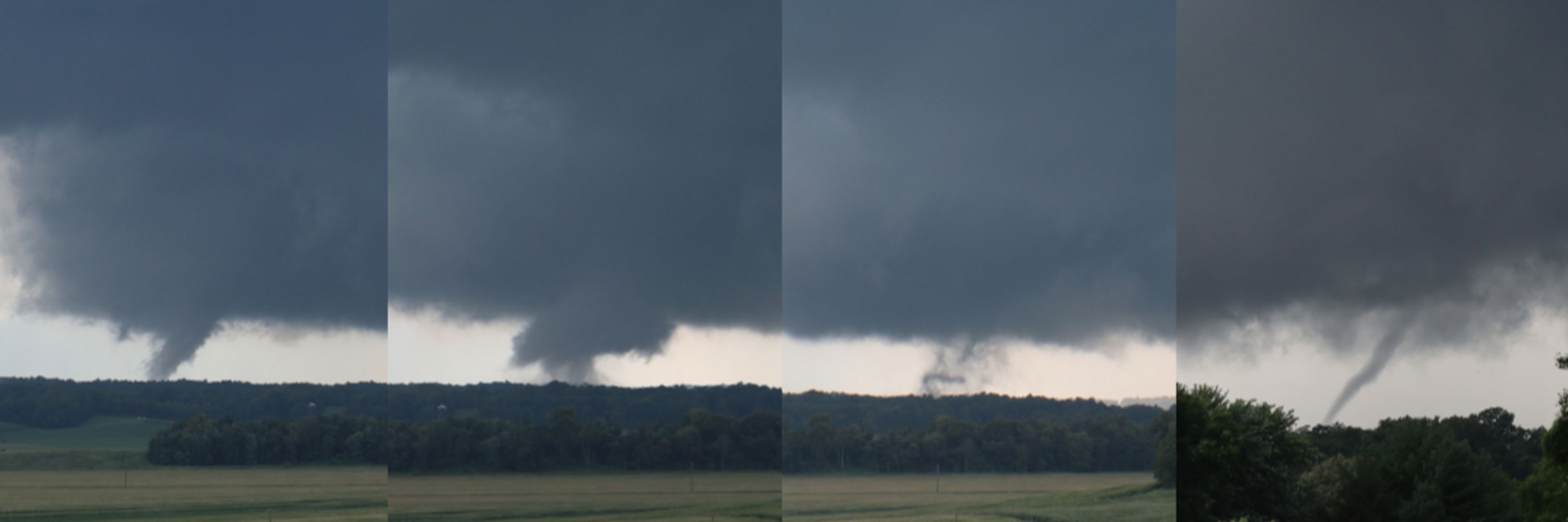
Saw a powerful tornado near Villa Ridge, MO last Friday with that historic tornado outbreak over the Mississippi River Valley.

March 17, 2025 at 5:14 PM
Saw a powerful tornado near Villa Ridge, MO last Friday with that historic tornado outbreak over the Mississippi River Valley.
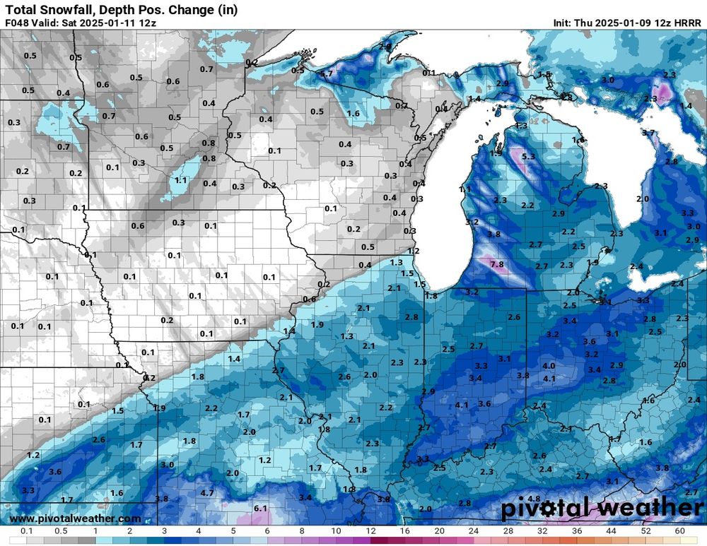
1-3” of snow possible across Central Illinois tomorrow. Winter weather advisories are up for many, but more may be placed soon areas further NW
January 9, 2025 at 4:48 PM
1-3” of snow possible across Central Illinois tomorrow. Winter weather advisories are up for many, but more may be placed soon areas further NW
merry christmas got a new coffee mug!!


December 25, 2024 at 7:19 PM
merry christmas got a new coffee mug!!
Job Shadowed at the National Weather Service in Lincoln, IL again today


December 11, 2024 at 10:21 PM
Job Shadowed at the National Weather Service in Lincoln, IL again today
Awesome sunset in Illinois tonight!!


December 8, 2024 at 1:32 AM
Awesome sunset in Illinois tonight!!


Illinois win and an awesome
sunset!
sunset!


November 16, 2024 at 11:39 PM
Illinois win and an awesome
sunset!
sunset!
framed a photo!

November 12, 2024 at 3:04 PM
framed a photo!
Tornado threat rapidly increasing in the vicinity of San Angelo, TX as the LLJ increases this evening. Solid thermodynamics will carve an environment favorable for large hail and tornado production now and Tonight over Central Texas! #WxSky


November 7, 2024 at 11:30 PM
Tornado threat rapidly increasing in the vicinity of San Angelo, TX as the LLJ increases this evening. Solid thermodynamics will carve an environment favorable for large hail and tornado production now and Tonight over Central Texas! #WxSky
Current view of #HurricaneRafael at 105 mph/959mb after exiting Cuba and now the ongoing EWRC cycle!

November 7, 2024 at 2:54 AM
Current view of #HurricaneRafael at 105 mph/959mb after exiting Cuba and now the ongoing EWRC cycle!
Well, the 500 mb pattern next weekend is quite intriguing due to the tropical systems in the gulf, it casts uncertainty on moisture. Also mid-level temps in the warm sector appear to be warmer than what would be ideal for severe storms. #WxSky


November 5, 2024 at 6:07 PM
Well, the 500 mb pattern next weekend is quite intriguing due to the tropical systems in the gulf, it casts uncertainty on moisture. Also mid-level temps in the warm sector appear to be warmer than what would be ideal for severe storms. #WxSky
NAM 3k has a very robust QLCS/embedded supercell threat from Central Texas into Central Missouri Monday. Solid instability w/good low level thermos combined with favorable QLCS wind vectors are strong 0-3 km shear are powering a threat for a few tornadoes (maybe a strong one).


November 2, 2024 at 7:00 PM
NAM 3k has a very robust QLCS/embedded supercell threat from Central Texas into Central Missouri Monday. Solid instability w/good low level thermos combined with favorable QLCS wind vectors are strong 0-3 km shear are powering a threat for a few tornadoes (maybe a strong one).
Well these showers aren't much right now, I would watch these closely. If a matured supercell can develop from this cluster of showers a strong tornado will take shape given the current wind profiles. #wxsky


October 30, 2024 at 11:37 PM
Well these showers aren't much right now, I would watch these closely. If a matured supercell can develop from this cluster of showers a strong tornado will take shape given the current wind profiles. #wxsky
Synoptically evident severe weather event over the Southern and Central Plains Wednesday with potential for all severe hazards. The greatest tornado threat exists in OK/S KS where the cold is likely to hold back leading to a traditional dry line setup. #WxSky


October 28, 2024 at 11:29 PM
Synoptically evident severe weather event over the Southern and Central Plains Wednesday with potential for all severe hazards. The greatest tornado threat exists in OK/S KS where the cold is likely to hold back leading to a traditional dry line setup. #WxSky


October 26, 2024 at 4:55 PM


October 25, 2024 at 3:29 AM
Storms are approaching the area for the first time in a long while!

October 24, 2024 at 11:22 PM
Storms are approaching the area for the first time in a long while!

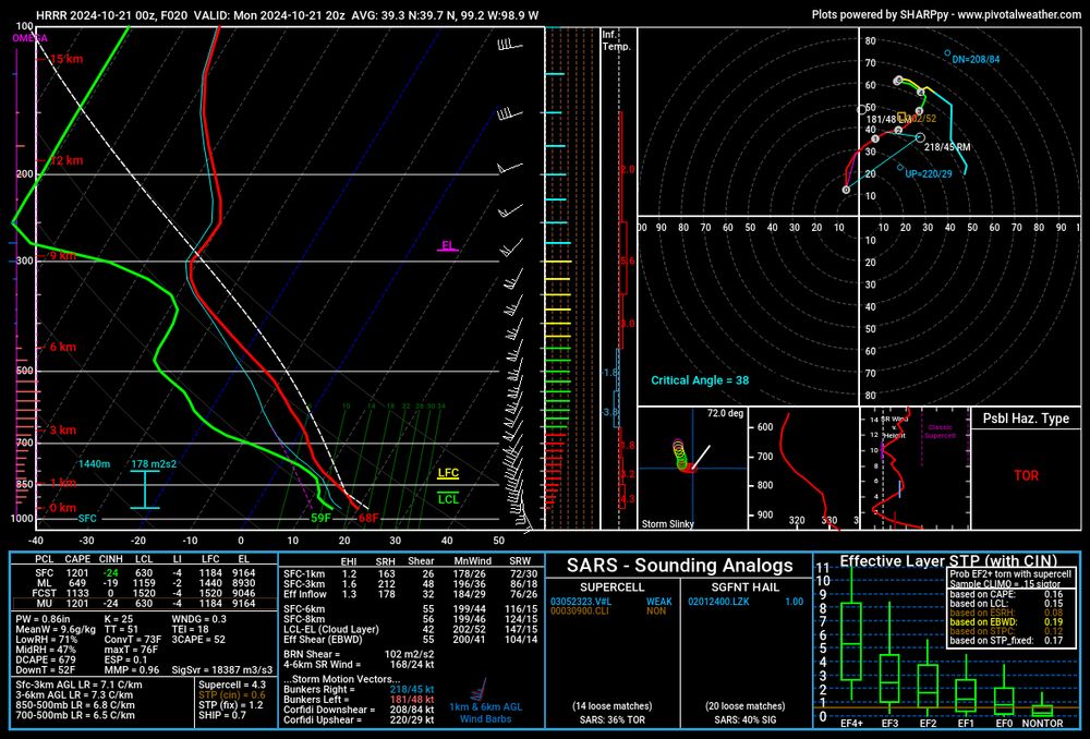
A classic cold core setup on tap tomorrow afternoon across Kansas, and perhaps Southern Nebraska. With strong wind fields in place, and modest instability in place a marginal tornado event could take place. This is pending how much sunshine occurs, and if storms outrun the small warm sector. #WxSky


October 21, 2024 at 1:50 AM
A classic cold core setup on tap tomorrow afternoon across Kansas, and perhaps Southern Nebraska. With strong wind fields in place, and modest instability in place a marginal tornado event could take place. This is pending how much sunshine occurs, and if storms outrun the small warm sector. #WxSky
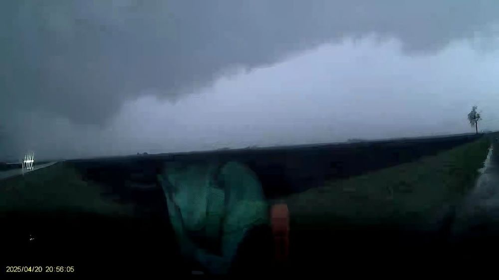
If you see this, it’s supercell Sunday!

October 20, 2024 at 10:00 PM
If you see this, it’s supercell Sunday!