


Jacob Feuerstein
@agnes1972.bsky.social
Private sector meteorologist. Flooding/weather history enthusiast. From the Northeast, currently living in the Midwest. Thoughts are mine alone.
And, of course, 1937- one of America's worst floods. Regionally similar but a degree more severe.

March 31, 2025 at 10:30 PM
And, of course, 1937- one of America's worst floods. Regionally similar but a degree more severe.
Comparing WPC's seven-day rain forecast to some significant regional flood events of the last thirty years. A major flood outbreak seems likely by mid-weekend from ArkLaTex to the OH Valley.


March 31, 2025 at 10:30 PM
Comparing WPC's seven-day rain forecast to some significant regional flood events of the last thirty years. A major flood outbreak seems likely by mid-weekend from ArkLaTex to the OH Valley.
Decreased visibility here in Madison with what I suspect is dust, lofted in west Texas and advected northeast. Very cool. Definitely doesn't have the typical wildfire smoke smell.

March 15, 2025 at 2:22 PM
Decreased visibility here in Madison with what I suspect is dust, lofted in west Texas and advected northeast. Very cool. Definitely doesn't have the typical wildfire smoke smell.
Top 20 tornado days, post-1950, by breadth of F3 tornado reports. This is defined as the size of a box drawn from the northwest to southeast that encompasses all intense tornadoes. This does not adjust for differences in longitude miles with latitude, sorry. Days with >3 F3 tornado reports included.


March 1, 2025 at 3:53 PM
Top 20 tornado days, post-1950, by breadth of F3 tornado reports. This is defined as the size of a box drawn from the northwest to southeast that encompasses all intense tornadoes. This does not adjust for differences in longitude miles with latitude, sorry. Days with >3 F3 tornado reports included.
Seeing a couple flash flood emergencies already for the corner of WV/VA. Conditions should continue to worsen into the overnight, especially as convection strengthens and moves through hard-hit areas. This is a major ongoing cold-season flood event.

February 15, 2025 at 10:31 PM
Seeing a couple flash flood emergencies already for the corner of WV/VA. Conditions should continue to worsen into the overnight, especially as convection strengthens and moves through hard-hit areas. This is a major ongoing cold-season flood event.
One of the largest D3 moderate risks I've ever seen now up for this threat. Suspect we could be seeing a high risk in E KY/WV tomorrow, we'll see.

February 14, 2025 at 2:17 AM
One of the largest D3 moderate risks I've ever seen now up for this threat. Suspect we could be seeing a high risk in E KY/WV tomorrow, we'll see.
It's rained up to 6+ inches in KY/WV over the last 14 days. Another 1-3 inches of rain and snow QPF expected over the work week. On Saturday, all of the snow melts, and 5-8+" of rain could fall locally with training storms somewhere in this region. Could be a good setup for substantial flooding.


February 11, 2025 at 12:11 AM
It's rained up to 6+ inches in KY/WV over the last 14 days. Another 1-3 inches of rain and snow QPF expected over the work week. On Saturday, all of the snow melts, and 5-8+" of rain could fall locally with training storms somewhere in this region. Could be a good setup for substantial flooding.
Twelve years ago tonight, southern New England's worst snowstorm since 1888. I measured 38" in my backyard in south-central Connecticut. It isn't the whole story, but I blame this storm for really igniting my interest in weather.


February 9, 2025 at 3:08 AM
Twelve years ago tonight, southern New England's worst snowstorm since 1888. I measured 38" in my backyard in south-central Connecticut. It isn't the whole story, but I blame this storm for really igniting my interest in weather.
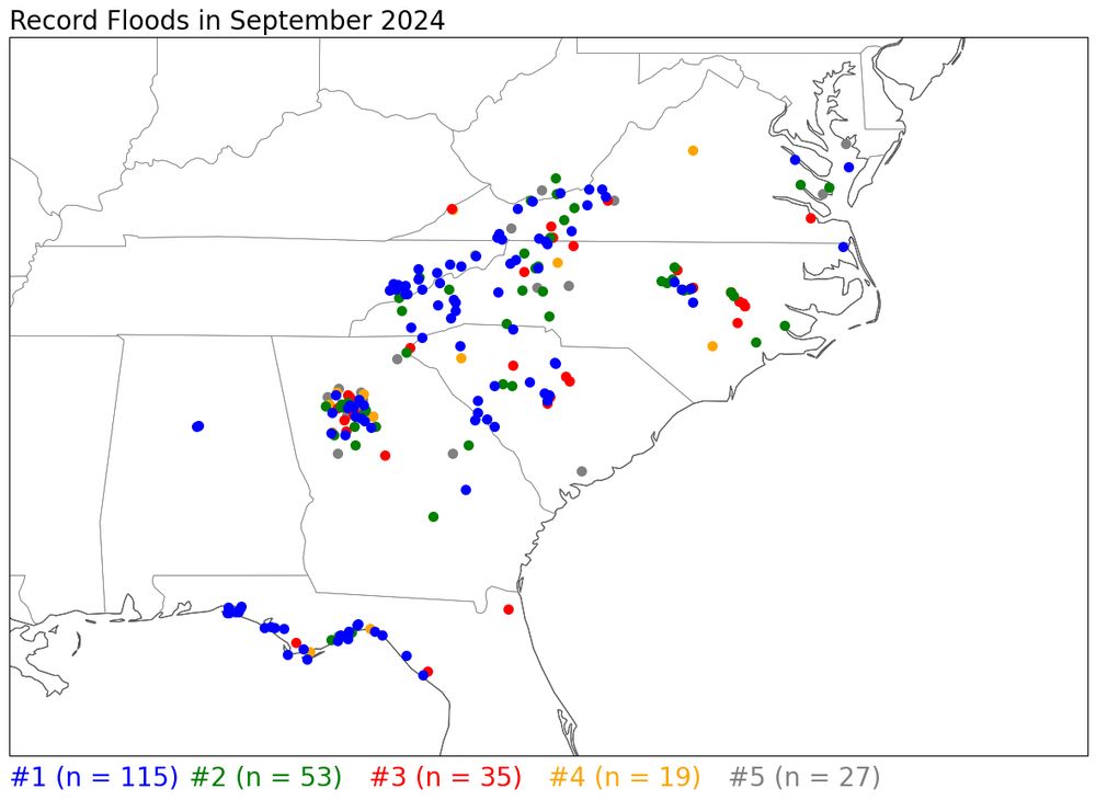
This is what 2024 looks like overall. Clearly records were driven by Helene, and by summer flooding in the western midwest.

January 26, 2025 at 6:49 PM
This is what 2024 looks like overall. Clearly records were driven by Helene, and by summer flooding in the western midwest.
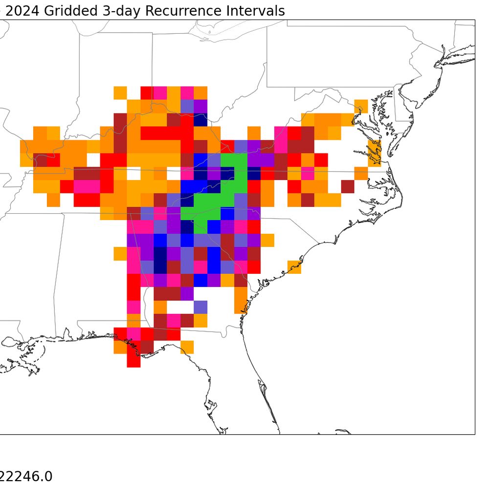
Thanks to Helene, September 2024 has become the month with the third most record crests in the national AHPS database.

January 26, 2025 at 6:48 PM
Thanks to Helene, September 2024 has become the month with the third most record crests in the national AHPS database.
Map of observed snowfall from the great Gulf Coast snow storm of 1895

January 21, 2025 at 9:04 PM
Map of observed snowfall from the great Gulf Coast snow storm of 1895
Woke up to a decent amount of snow in northern Allegheny County, which was a pretty big surprise- apparently, some Erie bands targeted my location with extreme precision

December 21, 2024 at 5:02 PM
Woke up to a decent amount of snow in northern Allegheny County, which was a pretty big surprise- apparently, some Erie bands targeted my location with extreme precision
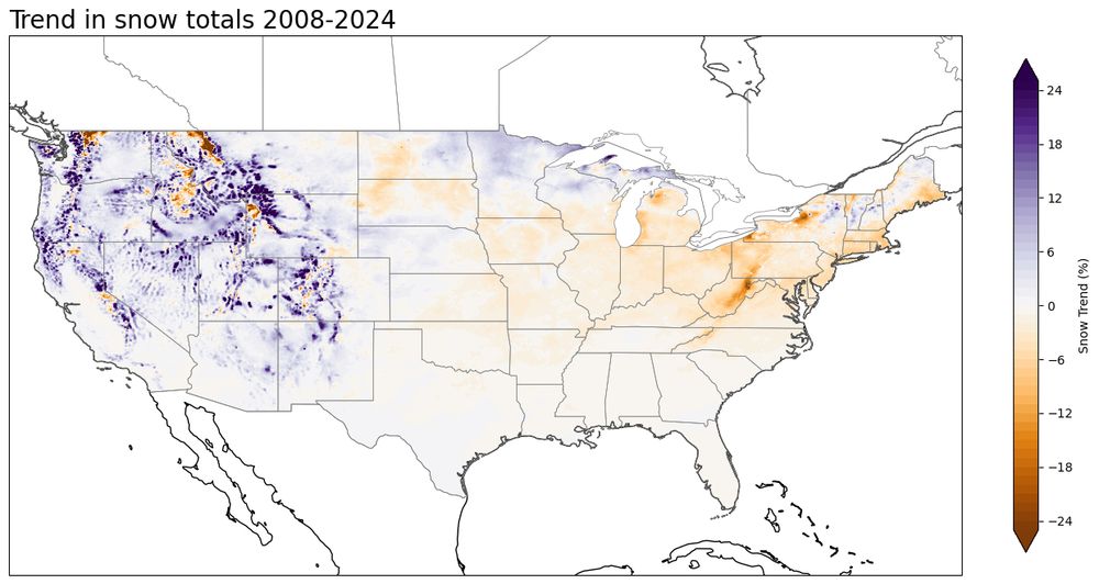
Trend in seasonal snow totals (via gridded NOHRSC snow data) over the last 16 years. Sad!
December 14, 2024 at 4:29 PM
Trend in seasonal snow totals (via gridded NOHRSC snow data) over the last 16 years. Sad!
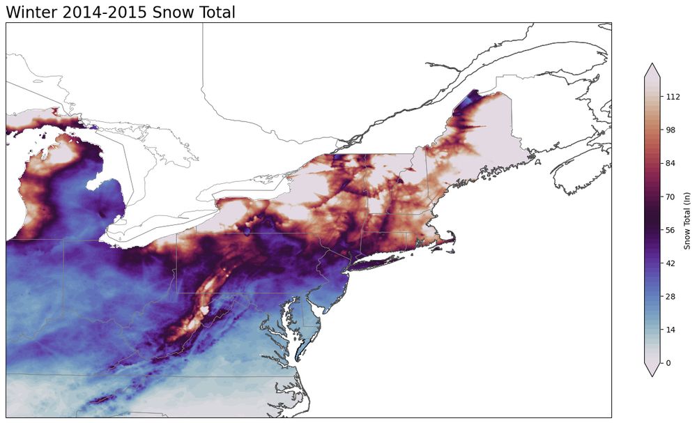
Having some fun with NOHRSC gridded data


December 14, 2024 at 4:10 PM
Having some fun with NOHRSC gridded data
30.78 inches makes Helene one of the most prolific rain events ever recorded from a TC in the interior US. The only other hurricane to drop comparable rain in Appalachia- Camille- killed 150+ in Nelson County, VA. Helene dropped such rain over a considerably larger area.

December 12, 2024 at 11:33 PM
30.78 inches makes Helene one of the most prolific rain events ever recorded from a TC in the interior US. The only other hurricane to drop comparable rain in Appalachia- Camille- killed 150+ in Nelson County, VA. Helene dropped such rain over a considerably larger area.
Three years ago today, a defining and unforgettable weather event.


December 11, 2024 at 12:43 AM
Three years ago today, a defining and unforgettable weather event.
A flooding event seems increasingly probable in the interior Northeast on Wednesday as a strong inland cutter drags a strong atmospheric river over a snowpack containing 1-4" of liquid. Stratiform rain and snowmelt followed by a convective line is a classic recipe for a cold season flood.


December 9, 2024 at 11:32 PM
A flooding event seems increasingly probable in the interior Northeast on Wednesday as a strong inland cutter drags a strong atmospheric river over a snowpack containing 1-4" of liquid. Stratiform rain and snowmelt followed by a convective line is a classic recipe for a cold season flood.


Roaring winds off Lake Mendota, in Madison, propelling frigid waves that are coating James Madison Park with ice. Midwest cold fronts are next level.
December 5, 2024 at 12:06 AM
Roaring winds off Lake Mendota, in Madison, propelling frigid waves that are coating James Madison Park with ice. Midwest cold fronts are next level.
exceptional amount of fire activity in the southeast amid today's dry, windy, mild conditions


December 3, 2024 at 11:31 PM
exceptional amount of fire activity in the southeast amid today's dry, windy, mild conditions
the most disappointing thing finally happened to me #WinDohSeat


December 3, 2024 at 12:57 AM
the most disappointing thing finally happened to me #WinDohSeat
In honor of the last day of 2024's hurricane season, a plot of what's probably the year's most important data: totals and recurrence intervals of rainfall from Helene.


December 1, 2024 at 1:42 AM
In honor of the last day of 2024's hurricane season, a plot of what's probably the year's most important data: totals and recurrence intervals of rainfall from Helene.
Wondering what this band of lake-effect-esque snow near Portage, WI is driven by? Perhaps a power plant/factory, or the Wisconsin River? Interesting either way


November 28, 2024 at 5:25 PM
Wondering what this band of lake-effect-esque snow near Portage, WI is driven by? Perhaps a power plant/factory, or the Wisconsin River? Interesting either way
Saratoga, NY solidly overperforming under persistent banding and temps hanging around 32 all morning. Handful of cars off the road on roads largely unsalted and poorly plowed. Also, already seeing some large branches down from the weight of the snow.


November 28, 2024 at 4:40 PM
Saratoga, NY solidly overperforming under persistent banding and temps hanging around 32 all morning. Handful of cars off the road on roads largely unsalted and poorly plowed. Also, already seeing some large branches down from the weight of the snow.
Almost forgot- I actually have plotted snow totals from the 1950 blizzard, via SC ACIS data. Really incomprehensible breadth and magnitude of snow with this unusual, intense cyclone

November 26, 2024 at 1:18 PM
Almost forgot- I actually have plotted snow totals from the 1950 blizzard, via SC ACIS data. Really incomprehensible breadth and magnitude of snow with this unusual, intense cyclone