


Aaron Koelker
@aaronkoelker.bsky.social
Shockingly, nobody took me up on running the #BostonMarathon with this thing strapped to their wrist
April 21, 2025 at 2:10 PM
Shockingly, nobody took me up on running the #BostonMarathon with this thing strapped to their wrist
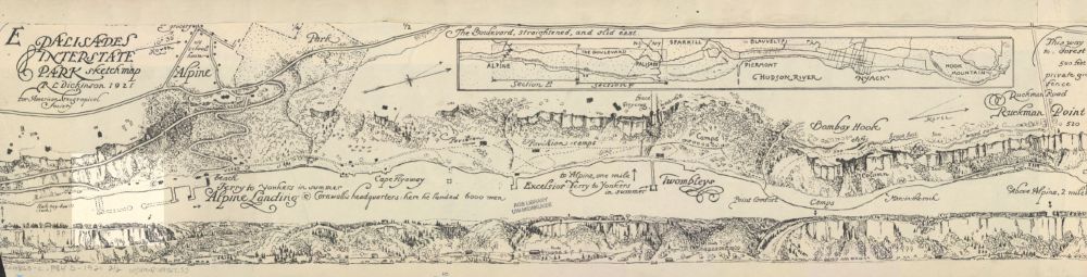
Currently obsessing over this 12 ft wide, 1921 strip #map of Palisades Interstate Park in NJ/NY. An amazingly detailed birds-eye view paired with a profile sketch of the park's cliffs, as seen from the Hudson River. collections.lib.uwm.edu/digital/coll...
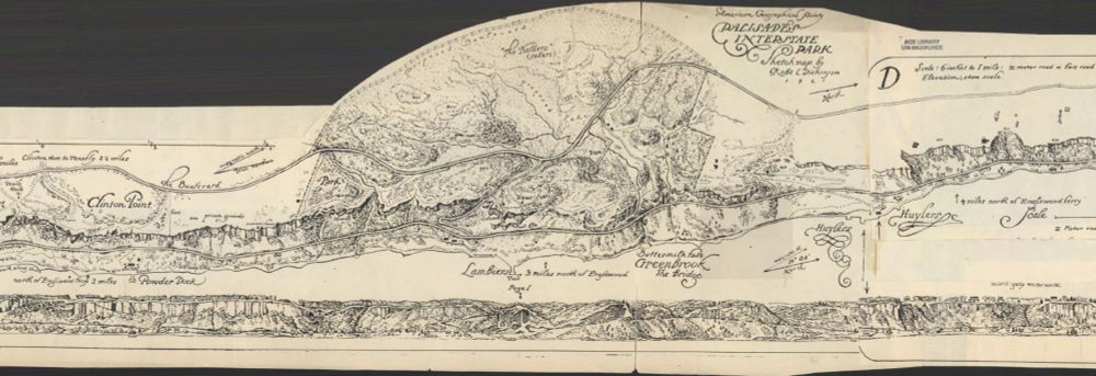
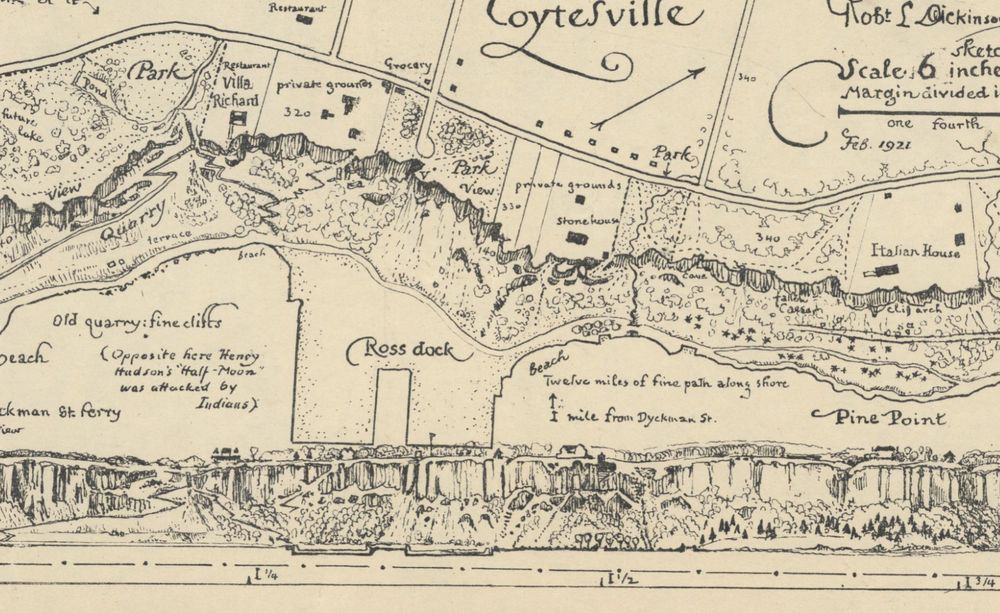
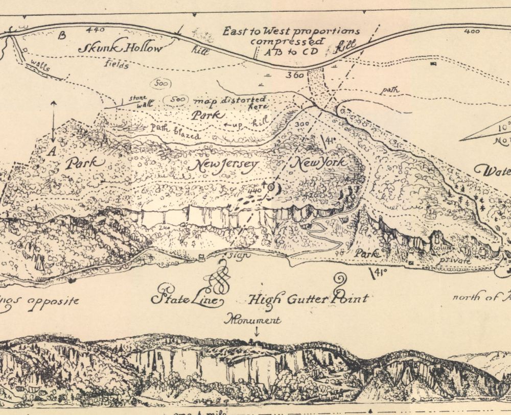
April 8, 2025 at 9:35 PM
Currently obsessing over this 12 ft wide, 1921 strip #map of Palisades Interstate Park in NJ/NY. An amazingly detailed birds-eye view paired with a profile sketch of the park's cliffs, as seen from the Hudson River. collections.lib.uwm.edu/digital/coll...
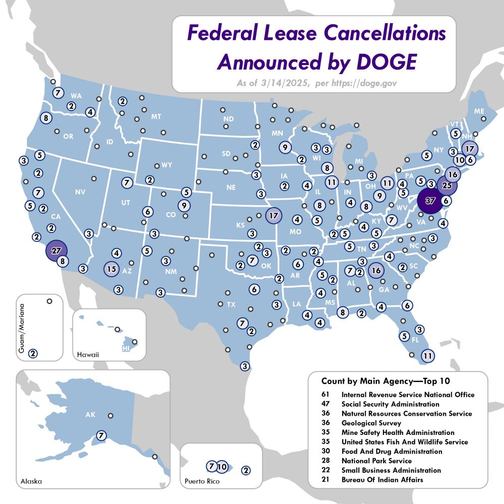
A quick and dirty map I made of the federal lease cancellations announced by DOGE so far. Data from DOGE's website on 3/14/25.
March 17, 2025 at 2:09 AM
A quick and dirty map I made of the federal lease cancellations announced by DOGE so far. Data from DOGE's website on 3/14/25.
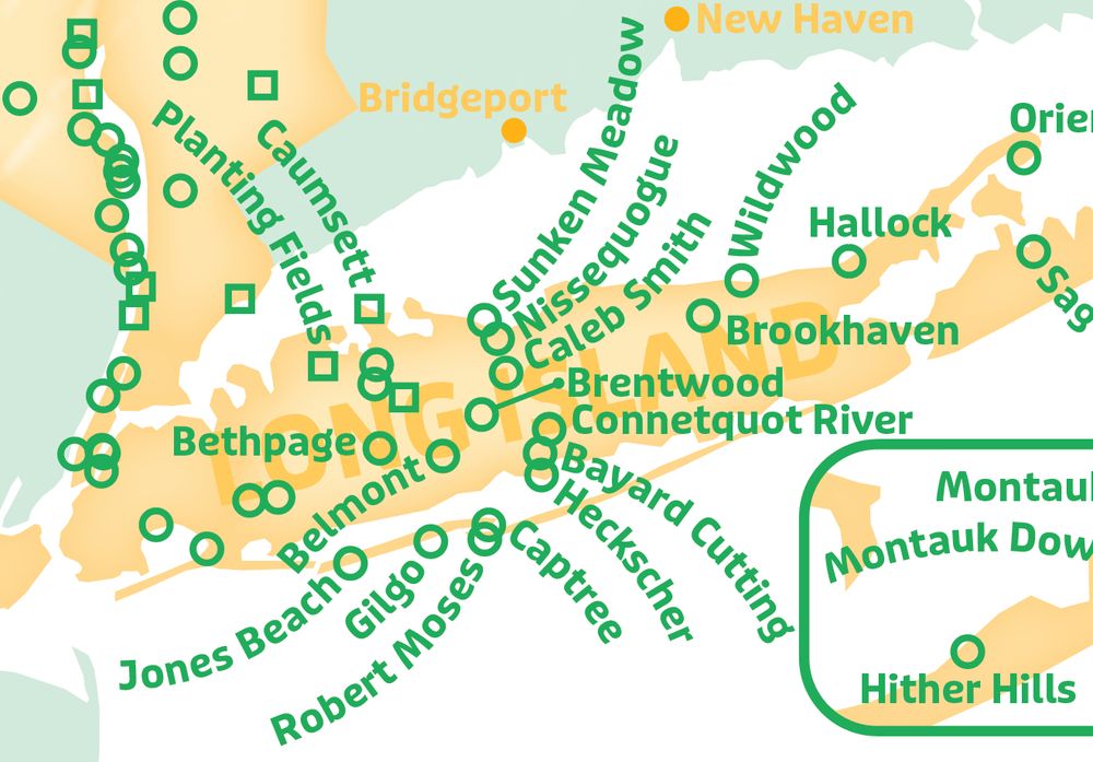
A particularly tricky round of Cartographer's Tetris
February 17, 2025 at 8:03 PM
A particularly tricky round of Cartographer's Tetris
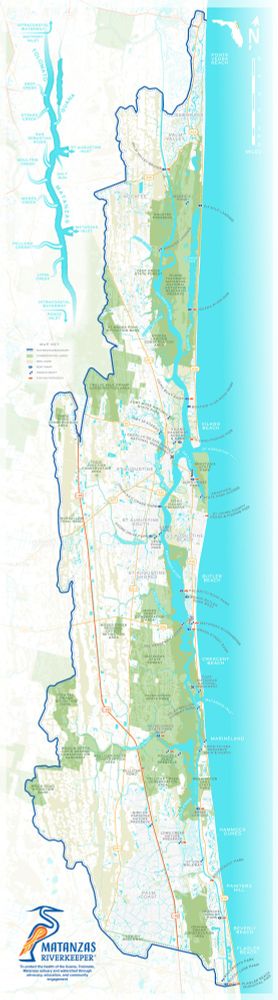
Recently updated this map for a watershed non-profit group to be vertical instead of horizontal. The original use-case was for tabling events, so we'd made it wide to get more of the map closer to the reader and save them from having to lean forward. The new layout is for signboards at boat ramps.
December 20, 2024 at 10:17 PM
Recently updated this map for a watershed non-profit group to be vertical instead of horizontal. The original use-case was for tabling events, so we'd made it wide to get more of the map closer to the reader and save them from having to lean forward. The new layout is for signboards at boat ramps.
This animation I made for a recent project shows the changes in ice extent over North America since the last glacial maximum (roughly 18k years). Each frame was hand drawn using Procreate.
December 11, 2024 at 9:28 PM
This animation I made for a recent project shows the changes in ice extent over North America since the last glacial maximum (roughly 18k years). Each frame was hand drawn using Procreate.
Happy Halloween. Here's a map I did several years ago of cemeteries and graveyards within Great Smoky Mountain National Park. Fun fact: the difference between a cemetery and a graveyard is that the latter is typically associated with a church.


October 31, 2024 at 11:21 PM
Happy Halloween. Here's a map I did several years ago of cemeteries and graveyards within Great Smoky Mountain National Park. Fun fact: the difference between a cemetery and a graveyard is that the latter is typically associated with a church.
This is a #map (?) I drew of Taughannock Gorge in upstate NY. I designed it specifically with a #risograph machine in mind, and printed it out at a community print space here in town. Excited to try out some other ideas there.


October 18, 2024 at 4:30 PM
This is a #map (?) I drew of Taughannock Gorge in upstate NY. I designed it specifically with a #risograph machine in mind, and printed it out at a community print space here in town. Excited to try out some other ideas there.
Working out another receipt map project idea

June 23, 2024 at 4:11 AM
Working out another receipt map project idea
Experimenting with a hand-drawn approach

May 30, 2024 at 7:36 PM
Experimenting with a hand-drawn approach
I recently moved to Ithaca, NY—so I made this #map of waterfalls to help get familiar with the area. I look forward to finding a typo immediately after posting.


May 23, 2024 at 9:02 PM
I recently moved to Ithaca, NY—so I made this #map of waterfalls to help get familiar with the area. I look forward to finding a typo immediately after posting.
Here's another ribbon map of a river; this time designed specifically for a receipt printer. Perhaps the most unnecessary thing I've ever made.


December 21, 2023 at 12:22 PM
Here's another ribbon map of a river; this time designed specifically for a receipt printer. Perhaps the most unnecessary thing I've ever made.
For the multiple people that suggested using a receipt printer. Not perfect, but readable! Will be a fun challenge designing a new map that works within the limitations.

November 7, 2023 at 1:28 PM
For the multiple people that suggested using a receipt printer. Not perfect, but readable! Will be a fun challenge designing a new map that works within the limitations.
More reposts, this 12ft long ribbon map of the Suwannee River with a 3D printed wind-up container. I'm now looking into buying a receipt printer... for reasons.


October 24, 2023 at 3:01 AM
More reposts, this 12ft long ribbon map of the Suwannee River with a 3D printed wind-up container. I'm now looking into buying a receipt printer... for reasons.
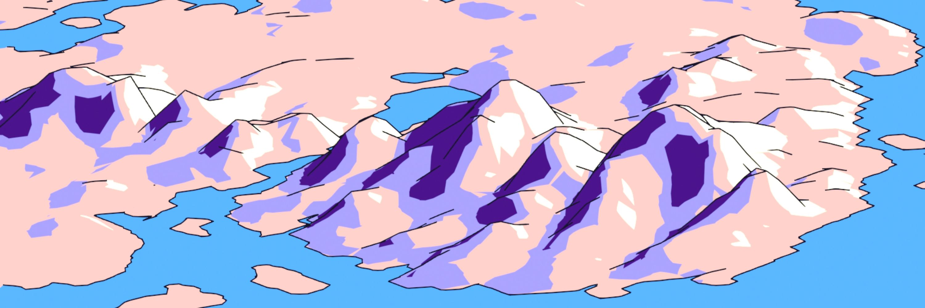
I'm going to repost some things from that old bird app for some semblance of continuity here, starting with this experimental Blender map of the St Kilda Archipelago I made a few months back.

October 23, 2023 at 1:16 PM
I'm going to repost some things from that old bird app for some semblance of continuity here, starting with this experimental Blender map of the St Kilda Archipelago I made a few months back.