


Aaron Koelker
@aaronkoelker.bsky.social
Pinned
Where curiosity leads: Crafting stories with Aaron Koelker
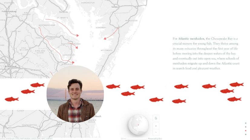
The ArcGIS StoryMaps team sits down with Aaron Koelker to discuss his approach to creating delightful and informative stories.
ow.ly
Excited I could chat with some of the StoryMaps team about, well, stories and maps. You can read some of the conversation here: ow.ly/cL1n50WzKHG
Excited I could chat with some of the StoryMaps team about, well, stories and maps. You can read some of the conversation here: ow.ly/cL1n50WzKHG
Where curiosity leads: Crafting stories with Aaron Koelker
The ArcGIS StoryMaps team sits down with Aaron Koelker to discuss his approach to creating delightful and informative stories.
ow.ly
August 7, 2025 at 11:56 PM
Excited I could chat with some of the StoryMaps team about, well, stories and maps. You can read some of the conversation here: ow.ly/cL1n50WzKHG
Shockingly, nobody took me up on running the #BostonMarathon with this thing strapped to their wrist
April 21, 2025 at 2:10 PM
Shockingly, nobody took me up on running the #BostonMarathon with this thing strapped to their wrist
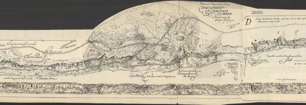
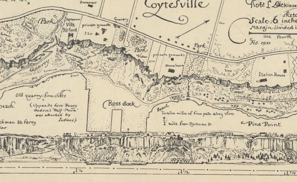
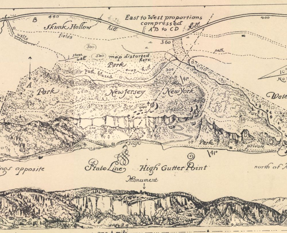
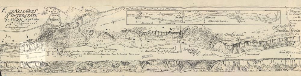
Currently obsessing over this 12 ft wide, 1921 strip #map of Palisades Interstate Park in NJ/NY. An amazingly detailed birds-eye view paired with a profile sketch of the park's cliffs, as seen from the Hudson River. collections.lib.uwm.edu/digital/coll...
April 8, 2025 at 9:35 PM
Currently obsessing over this 12 ft wide, 1921 strip #map of Palisades Interstate Park in NJ/NY. An amazingly detailed birds-eye view paired with a profile sketch of the park's cliffs, as seen from the Hudson River. collections.lib.uwm.edu/digital/coll...
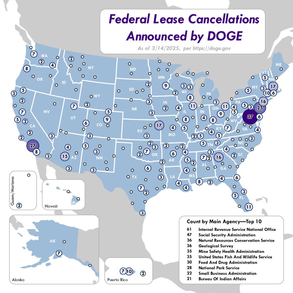
A quick and dirty map I made of the federal lease cancellations announced by DOGE so far. Data from DOGE's website on 3/14/25.
March 17, 2025 at 2:09 AM
A quick and dirty map I made of the federal lease cancellations announced by DOGE so far. Data from DOGE's website on 3/14/25.
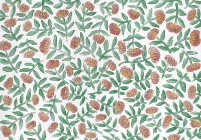
A few months ago, I made this #StoryMap about glacial relicts and refugia, with a look inspired by botanical field journals. It was a fun side-project to reseach and create. storymaps.arcgis.com/stories/9b04...
Glacial Gardens
Relicts, Refugia, and Preserving Biodiversity
storymaps.arcgis.com
March 3, 2025 at 2:42 PM
A few months ago, I made this #StoryMap about glacial relicts and refugia, with a look inspired by botanical field journals. It was a fun side-project to reseach and create. storymaps.arcgis.com/stories/9b04...
A particularly tricky round of Cartographer's Tetris
February 17, 2025 at 8:03 PM
A particularly tricky round of Cartographer's Tetris
Maps.com is doing a new series on the mapmaking process and asked me to talk about my map of map turtles. I also recommend the first entry with @peterincan.bsky.social and his awesome wildfire map. www.maps.com/behind-the-m...
Behind the Map | Maps.com
Get insights into the mapmaking process and hear directly from cartographers and creators who share the how and why behind some of our favorite maps.
www.maps.com
January 16, 2025 at 5:08 PM
Maps.com is doing a new series on the mapmaking process and asked me to talk about my map of map turtles. I also recommend the first entry with @peterincan.bsky.social and his awesome wildfire map. www.maps.com/behind-the-m...
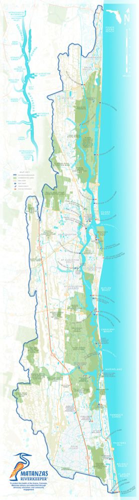
Recently updated this map for a watershed non-profit group to be vertical instead of horizontal. The original use-case was for tabling events, so we'd made it wide to get more of the map closer to the reader and save them from having to lean forward. The new layout is for signboards at boat ramps.
December 20, 2024 at 10:17 PM
Recently updated this map for a watershed non-profit group to be vertical instead of horizontal. The original use-case was for tabling events, so we'd made it wide to get more of the map closer to the reader and save them from having to lean forward. The new layout is for signboards at boat ramps.
This animation I made for a recent project shows the changes in ice extent over North America since the last glacial maximum (roughly 18k years). Each frame was hand drawn using Procreate.
December 11, 2024 at 9:28 PM
This animation I made for a recent project shows the changes in ice extent over North America since the last glacial maximum (roughly 18k years). Each frame was hand drawn using Procreate.
Reposted by Aaron Koelker

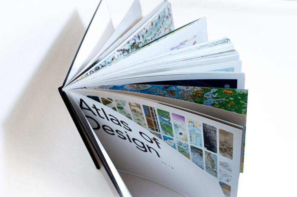
Share the joy of maps with a gift of the Atlas of Design! And why not donate a copy to your local library, school, or book drive? All volumes of the Atlas are now available to ship, including the recently released Volume 7.
atlasofdesign.org/order/
atlasofdesign.org/order/
December 10, 2024 at 6:07 PM
Share the joy of maps with a gift of the Atlas of Design! And why not donate a copy to your local library, school, or book drive? All volumes of the Atlas are now available to ship, including the recently released Volume 7.
atlasofdesign.org/order/
atlasofdesign.org/order/
Happy Halloween. Here's a map I did several years ago of cemeteries and graveyards within Great Smoky Mountain National Park. Fun fact: the difference between a cemetery and a graveyard is that the latter is typically associated with a church.


October 31, 2024 at 11:21 PM
Happy Halloween. Here's a map I did several years ago of cemeteries and graveyards within Great Smoky Mountain National Park. Fun fact: the difference between a cemetery and a graveyard is that the latter is typically associated with a church.
This is a #map (?) I drew of Taughannock Gorge in upstate NY. I designed it specifically with a #risograph machine in mind, and printed it out at a community print space here in town. Excited to try out some other ideas there.


October 18, 2024 at 4:30 PM
This is a #map (?) I drew of Taughannock Gorge in upstate NY. I designed it specifically with a #risograph machine in mind, and printed it out at a community print space here in town. Excited to try out some other ideas there.
Since videos don't work here yet: Here's a link to another 10ft receipt map I made of the Boston Marathon. It's contained in an enduro route sheet holder so that, theoretically, someone could awkwardly reference this on their wrist while as race. aaronkoelker.com/boston-marat...
BOSTON MARATHON – Aaron Koelker
aaronkoelker.com
July 16, 2024 at 3:50 AM
Since videos don't work here yet: Here's a link to another 10ft receipt map I made of the Boston Marathon. It's contained in an enduro route sheet holder so that, theoretically, someone could awkwardly reference this on their wrist while as race. aaronkoelker.com/boston-marat...
Working out another receipt map project idea

June 23, 2024 at 4:11 AM
Working out another receipt map project idea
Experimenting with a hand-drawn approach

May 30, 2024 at 7:36 PM
Experimenting with a hand-drawn approach
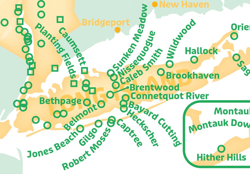
I recently moved to Ithaca, NY—so I made this #map of waterfalls to help get familiar with the area. I look forward to finding a typo immediately after posting.


May 23, 2024 at 9:02 PM
I recently moved to Ithaca, NY—so I made this #map of waterfalls to help get familiar with the area. I look forward to finding a typo immediately after posting.
Here's a technique I've been using to create dynamic highlights on my data in ArcGIS Online—handy for a bit of extra visual flair or filtering out data when you don't have the right attributes. I've been using it with shifting hurricane forecast cones. youtu.be/M7e2N3c_WvI?...

Creating Dynamic Highlights and Masks in ArcGIS Online with Blend Modes
Using groups and blend modes, we can create on-the-fly highlights and masks for feature layers in the ArcGIS Online Map Viewer. This can give us some nifty v...
youtu.be
February 2, 2024 at 4:08 AM
Here's a technique I've been using to create dynamic highlights on my data in ArcGIS Online—handy for a bit of extra visual flair or filtering out data when you don't have the right attributes. I've been using it with shifting hurricane forecast cones. youtu.be/M7e2N3c_WvI?...
Here's another ribbon map of a river; this time designed specifically for a receipt printer. Perhaps the most unnecessary thing I've ever made.


December 21, 2023 at 12:22 PM
Here's another ribbon map of a river; this time designed specifically for a receipt printer. Perhaps the most unnecessary thing I've ever made.
For the multiple people that suggested using a receipt printer. Not perfect, but readable! Will be a fun challenge designing a new map that works within the limitations.

November 7, 2023 at 1:28 PM
For the multiple people that suggested using a receipt printer. Not perfect, but readable! Will be a fun challenge designing a new map that works within the limitations.
Florida citrus isn't doing so well. Here's a #StoryMap I'd been working on that takes a closer look at the different challenges facing the industry. arcg.is/5rHLa0

Green Oranges & Land
Challenges and Change in Florida Citrus
arcg.is
October 24, 2023 at 8:21 PM
Florida citrus isn't doing so well. Here's a #StoryMap I'd been working on that takes a closer look at the different challenges facing the industry. arcg.is/5rHLa0
More reposts, this 12ft long ribbon map of the Suwannee River with a 3D printed wind-up container. I'm now looking into buying a receipt printer... for reasons.


October 24, 2023 at 3:01 AM
More reposts, this 12ft long ribbon map of the Suwannee River with a 3D printed wind-up container. I'm now looking into buying a receipt printer... for reasons.
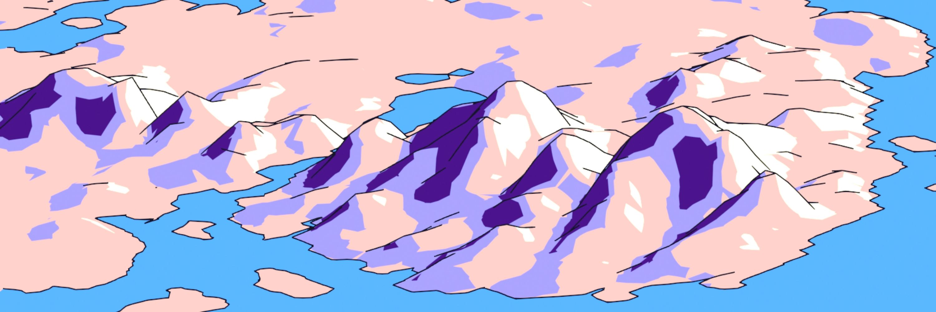
I'm going to repost some things from that old bird app for some semblance of continuity here, starting with this experimental Blender map of the St Kilda Archipelago I made a few months back.

October 23, 2023 at 1:16 PM
I'm going to repost some things from that old bird app for some semblance of continuity here, starting with this experimental Blender map of the St Kilda Archipelago I made a few months back.