


Youwei Wang
@youweiwang.bsky.social
Fluvial geomorphologist, sedimentologist, and stratigrapher at University of Virginia. PhD. from TU Delft.
Pinned
Youwei Wang
@youweiwang.bsky.social
· May 7

🐱New Paper Alert: Some Work on Cat and Geomorphology🐱
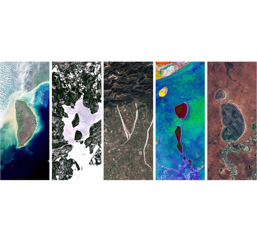
Bridging Gaps in Satellite Observations of River and Delta Landscapes Using Image Warping, by Youwei Wang, Yuan Li, and Ajay Limaye (Water Resources Research, 2025).
OA paper: doi.org/10.1029/2024...
Quick overview: AGU 2024 poster attached.
Bridging Gaps in Satellite Observations of River and Delta Landscapes Using Image Warping, by Youwei Wang, Yuan Li, and Ajay Limaye (Water Resources Research, 2025).
OA paper: doi.org/10.1029/2024...
Quick overview: AGU 2024 poster attached.
Reposted by Youwei Wang
What if you laid out all the meanders of a river along a straight line, so that you can break the river into straight-ish segments and fill arbitrary spaces? This is the Purus River in Brazil; you can see how it is getting wider and the meanders are getting larger in the downstream direction

May 23, 2025 at 1:29 AM
What if you laid out all the meanders of a river along a straight line, so that you can break the river into straight-ish segments and fill arbitrary spaces? This is the Purus River in Brazil; you can see how it is getting wider and the meanders are getting larger in the downstream direction
Reposted by Youwei Wang
Join us tomorrow Thu. May 8 at 16:00 CEST for a talk by Jaap Nienhuis @changing-shores.bsky.social :
Global Delta Morphodynamics: why and how?
🌎🌍🌏
🔺❓🚩
📐🔻🔼
www.landscapeslive.org
Global Delta Morphodynamics: why and how?
🌎🌍🌏
🔺❓🚩
📐🔻🔼
www.landscapeslive.org
Landscapes Live
Landscapes Live is a weekly online seminar series freely accessible to the international scientific community interested in various aspects of geomorphology. Our talks take place on Zoom every Thursda...
www.landscapeslive.org
May 7, 2025 at 9:03 PM
Join us tomorrow Thu. May 8 at 16:00 CEST for a talk by Jaap Nienhuis @changing-shores.bsky.social :
Global Delta Morphodynamics: why and how?
🌎🌍🌏
🔺❓🚩
📐🔻🔼
www.landscapeslive.org
Global Delta Morphodynamics: why and how?
🌎🌍🌏
🔺❓🚩
📐🔻🔼
www.landscapeslive.org
🐱New Paper Alert: Some Work on Cat and Geomorphology🐱
Bridging Gaps in Satellite Observations of River and Delta Landscapes Using Image Warping, by Youwei Wang, Yuan Li, and Ajay Limaye (Water Resources Research, 2025).
OA paper: doi.org/10.1029/2024...
Quick overview: AGU 2024 poster attached.
Bridging Gaps in Satellite Observations of River and Delta Landscapes Using Image Warping, by Youwei Wang, Yuan Li, and Ajay Limaye (Water Resources Research, 2025).
OA paper: doi.org/10.1029/2024...
Quick overview: AGU 2024 poster attached.
May 7, 2025 at 11:11 PM
🐱New Paper Alert: Some Work on Cat and Geomorphology🐱
Bridging Gaps in Satellite Observations of River and Delta Landscapes Using Image Warping, by Youwei Wang, Yuan Li, and Ajay Limaye (Water Resources Research, 2025).
OA paper: doi.org/10.1029/2024...
Quick overview: AGU 2024 poster attached.
Bridging Gaps in Satellite Observations of River and Delta Landscapes Using Image Warping, by Youwei Wang, Yuan Li, and Ajay Limaye (Water Resources Research, 2025).
OA paper: doi.org/10.1029/2024...
Quick overview: AGU 2024 poster attached.
Reposted by Youwei Wang
The talk by @sineadlyster.bsky.social is uploaded to youtube!
The impact of vegetation on delta landscapes and stratigraphy: Insights from physical experiments
🌱🌱🌱
🟨🟨🟨🟦🟦
🟨🟨🟨🟨🟦
youtu.be/1xGKVL-2HMc
The impact of vegetation on delta landscapes and stratigraphy: Insights from physical experiments
🌱🌱🌱
🟨🟨🟨🟦🟦
🟨🟨🟨🟨🟦
youtu.be/1xGKVL-2HMc

Sinead Lyster: LL 24.04.25
YouTube video by Landscapes Live
youtu.be
April 24, 2025 at 5:31 PM
The talk by @sineadlyster.bsky.social is uploaded to youtube!
The impact of vegetation on delta landscapes and stratigraphy: Insights from physical experiments
🌱🌱🌱
🟨🟨🟨🟦🟦
🟨🟨🟨🟨🟦
youtu.be/1xGKVL-2HMc
The impact of vegetation on delta landscapes and stratigraphy: Insights from physical experiments
🌱🌱🌱
🟨🟨🟨🟦🟦
🟨🟨🟨🟨🟦
youtu.be/1xGKVL-2HMc
Reposted by Youwei Wang

Psst…You want to know about the NASA website that spells out your name in Landsat imagery. 🧪
landsat.gsfc.nasa.gov/apps/YourNam...
landsat.gsfc.nasa.gov/apps/YourNam...
August 31, 2024 at 2:00 AM
Psst…You want to know about the NASA website that spells out your name in Landsat imagery. 🧪
landsat.gsfc.nasa.gov/apps/YourNam...
landsat.gsfc.nasa.gov/apps/YourNam...
Reposted by Youwei Wang
This week's LL seminar will be by @jakegearon.bsky.social :
"How River Avulsions Work"
💧
💧⤵️
❌💧
Thursday March 20th, Berlin@16, London@15, Rio@12, NYC@11, LA@8
www.landscapeslive.org
"How River Avulsions Work"
💧
💧⤵️
❌💧
Thursday March 20th, Berlin@16, London@15, Rio@12, NYC@11, LA@8
www.landscapeslive.org

Landscapes Live
Landscapes Live is a weekly online seminar series freely accessible to the international scientific community interested in various aspects of geomorphology. Our talks take place on Zoom every Thursda...
www.landscapeslive.org
March 17, 2025 at 10:19 AM
This week's LL seminar will be by @jakegearon.bsky.social :
"How River Avulsions Work"
💧
💧⤵️
❌💧
Thursday March 20th, Berlin@16, London@15, Rio@12, NYC@11, LA@8
www.landscapeslive.org
"How River Avulsions Work"
💧
💧⤵️
❌💧
Thursday March 20th, Berlin@16, London@15, Rio@12, NYC@11, LA@8
www.landscapeslive.org
Reposted by Youwei Wang
LL Season opener with @paul-bierman.bsky.social this Thursday March 13th!
"A landscape under the ice: Camp Century, Greenland"
🧊🧊🧊
🏞️🏞️🏞️
ℹ️🔗 www.landscapeslive.org
20:30 Mumbai
16:00 Paris
15:00 London
12:00 Rio
11:00 NYC
08:00 LA
"A landscape under the ice: Camp Century, Greenland"
🧊🧊🧊
🏞️🏞️🏞️
ℹ️🔗 www.landscapeslive.org
20:30 Mumbai
16:00 Paris
15:00 London
12:00 Rio
11:00 NYC
08:00 LA
Landscapes Live
Landscapes Live is a weekly online seminar series freely accessible to the international scientific community interested in various aspects of geomorphology. Our talks take place on Zoom every Thursda...
www.landscapeslive.org
March 10, 2025 at 2:14 PM
LL Season opener with @paul-bierman.bsky.social this Thursday March 13th!
"A landscape under the ice: Camp Century, Greenland"
🧊🧊🧊
🏞️🏞️🏞️
ℹ️🔗 www.landscapeslive.org
20:30 Mumbai
16:00 Paris
15:00 London
12:00 Rio
11:00 NYC
08:00 LA
"A landscape under the ice: Camp Century, Greenland"
🧊🧊🧊
🏞️🏞️🏞️
ℹ️🔗 www.landscapeslive.org
20:30 Mumbai
16:00 Paris
15:00 London
12:00 Rio
11:00 NYC
08:00 LA
Reposted by Youwei Wang
Hello Bluesky! 🦋🏞️
We are organizing weekly seminars for scientists to present their research in and around geomorphology.
Affiliated with @eurogeosciences.bsky.social GM
More information on our website: www.landscapeslive.org
We are organizing weekly seminars for scientists to present their research in and around geomorphology.
Affiliated with @eurogeosciences.bsky.social GM
More information on our website: www.landscapeslive.org
Landscapes Live
Landscapes Live is a weekly online seminar series freely accessible to the international scientific community interested in various aspects of geomorphology. Our talks take place on Zoom every Thursda...
www.landscapeslive.org
February 23, 2025 at 4:06 PM
Hello Bluesky! 🦋🏞️
We are organizing weekly seminars for scientists to present their research in and around geomorphology.
Affiliated with @eurogeosciences.bsky.social GM
More information on our website: www.landscapeslive.org
We are organizing weekly seminars for scientists to present their research in and around geomorphology.
Affiliated with @eurogeosciences.bsky.social GM
More information on our website: www.landscapeslive.org
Reposted by Youwei Wang
Landscape evolution modeling with Landlab in my 300-level geomorph class this week. I like to add a heavy dose of fluvial erosion at the end so it turns into a Loess Plateau/Loess Canyons of Nebraska kind of landscape. I can't say enough good things about Landlab and the people who developed it


February 12, 2025 at 10:23 PM
Landscape evolution modeling with Landlab in my 300-level geomorph class this week. I like to add a heavy dose of fluvial erosion at the end so it turns into a Loess Plateau/Loess Canyons of Nebraska kind of landscape. I can't say enough good things about Landlab and the people who developed it
Reposted by Youwei Wang
A couple of meanders on the Ural River, Kazakhstan and similar geometries + age distribution on the point bars in a simple model of #meandering 🧪⚒️


January 11, 2025 at 10:19 PM
A couple of meanders on the Ural River, Kazakhstan and similar geometries + age distribution on the point bars in a simple model of #meandering 🧪⚒️
Reposted by Youwei Wang
Meanders as wrinkles in time. Every time step in the animation is a 3D-printable object 🧪⚒️
December 21, 2024 at 6:55 PM
Meanders as wrinkles in time. Every time step in the animation is a 3D-printable object 🧪⚒️
Reposted by Youwei Wang

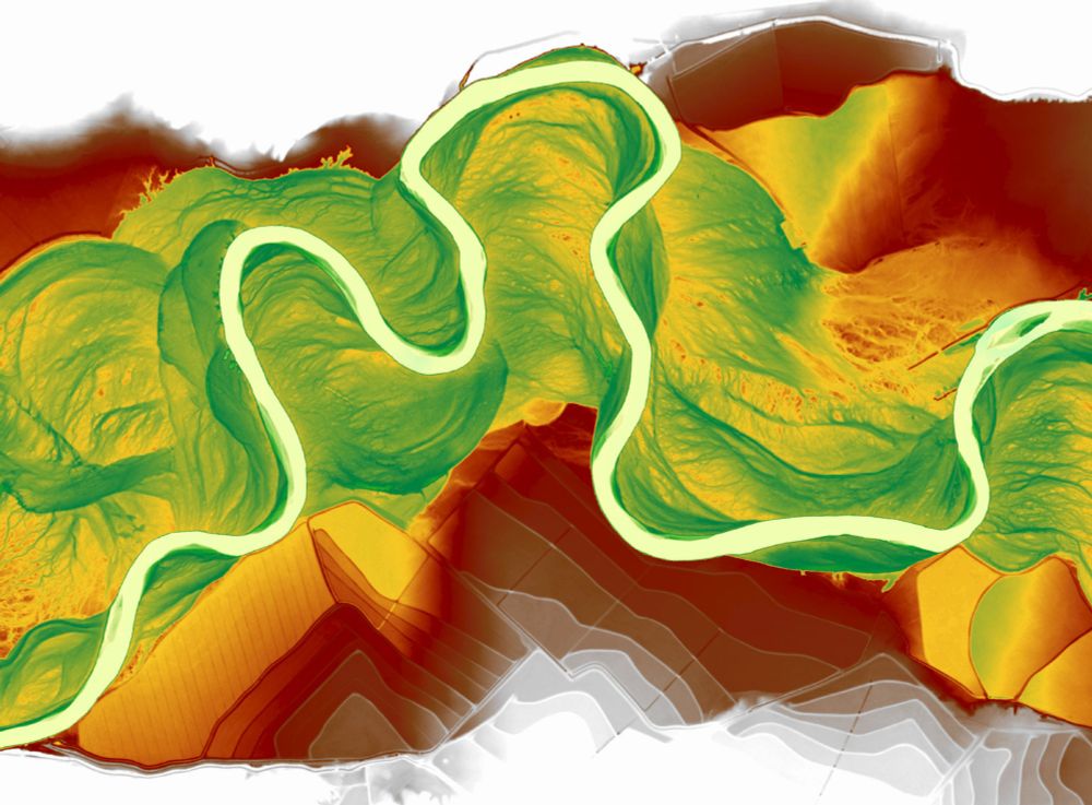
Relative elevation model of Powder River near Broadus, Montana. So fun to see the floodplain features pop with a bit of color!
November 19, 2024 at 10:50 PM
Relative elevation model of Powder River near Broadus, Montana. So fun to see the floodplain features pop with a bit of color!
Using reconstructed images, we create synthetic stratigraphy for the Ucayali River based on estimated aggradation and channel preservation rates. Though not fully realistic, it might be helpful for comparing with field data. Spot the two 5m-tall (unrealistic for sure) geologists for scale? :)

November 12, 2024 at 2:49 PM
Using reconstructed images, we create synthetic stratigraphy for the Ucayali River based on estimated aggradation and channel preservation rates. Though not fully realistic, it might be helpful for comparing with field data. Spot the two 5m-tall (unrealistic for sure) geologists for scale? :)
Image warping offers powerful solutions for reconstructing landscape evolution, even with incomplete satellite data. Check out these examples: from simple head-turning motions in cats to detailed reconstructions of the Ucayali River and Wax Lake Delta, all using just two input images!
November 12, 2024 at 2:42 PM
Image warping offers powerful solutions for reconstructing landscape evolution, even with incomplete satellite data. Check out these examples: from simple head-turning motions in cats to detailed reconstructions of the Ucayali River and Wax Lake Delta, all using just two input images!