


wedery
@wedery.bsky.social
Pinned
wedery
@wedery.bsky.social
· Jul 9

Some unrelated news. Probably.
We did actually move our website's framework to Next.js as well as some other improvements. Check it out here:
wedery.pages.dev
We did actually move our website's framework to Next.js as well as some other improvements. Check it out here:
wedery.pages.dev
Reposted by wedery


November 2, 2025 at 3:18 AM
Reposted by wedery

Photographs of Super Typhoon #Ragasa shared by JAXA astronaut YUI Kamiya aboard the ISS.
Original post: xcancel.com/Astro_Kimiya...
#NandoPH #台風18号
Original post: xcancel.com/Astro_Kimiya...
#NandoPH #台風18号


September 22, 2025 at 8:17 AM
Photographs of Super Typhoon #Ragasa shared by JAXA astronaut YUI Kamiya aboard the ISS.
Original post: xcancel.com/Astro_Kimiya...
#NandoPH #台風18号
Original post: xcancel.com/Astro_Kimiya...
#NandoPH #台風18号
Chances are, Ragasa (#NandoPH) will go nuclear. For anyone in Batanes and the Babuyan Islands in the Philippines, please prepare accordingly!
📸 Tropical Tidbits
(P.S. we're not fully back yet, just wanted to get the word out about this storm!)
📸 Tropical Tidbits
(P.S. we're not fully back yet, just wanted to get the word out about this storm!)

September 19, 2025 at 10:26 AM
Chances are, Ragasa (#NandoPH) will go nuclear. For anyone in Batanes and the Babuyan Islands in the Philippines, please prepare accordingly!
📸 Tropical Tidbits
(P.S. we're not fully back yet, just wanted to get the word out about this storm!)
📸 Tropical Tidbits
(P.S. we're not fully back yet, just wanted to get the word out about this storm!)
Again, due to health reasons, all operations from wedery will completely cease indefinitely until further notice. No guarantee on when things will resume, but there's still a good chance that they will, sooner or later. Thanks for your patience!
July 27, 2025 at 2:08 PM
Again, due to health reasons, all operations from wedery will completely cease indefinitely until further notice. No guarantee on when things will resume, but there's still a good chance that they will, sooner or later. Thanks for your patience!
Reposted by wedery

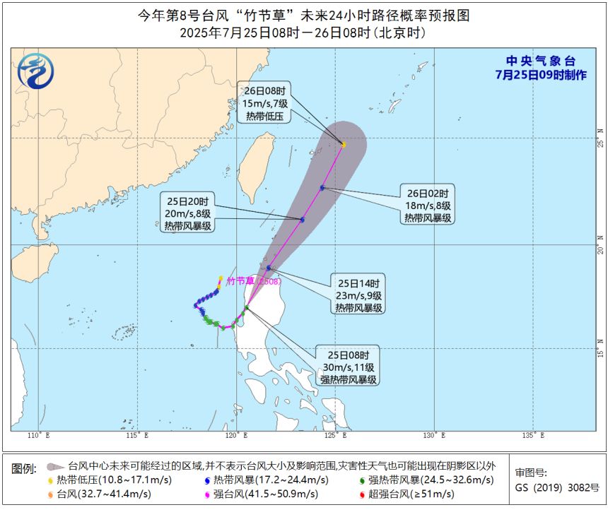
#Comay could merge with #Invest91W impacting #Japan 's #Okinawa #Amami #Kagoshima then to N #Zhejiang #Shanghai S #Jiangsu
interests should finish preps now!
#Wxx #Wxtwitter #Tropicswx #BlueSkyWx #台風8号 #EmongPh #Naha #Tropicalstormcomay #TropicalStorm #China #91W #Ningbo #Shanghai #Hangzhou #Suzhou
interests should finish preps now!
#Wxx #Wxtwitter #Tropicswx #BlueSkyWx #台風8号 #EmongPh #Naha #Tropicalstormcomay #TropicalStorm #China #91W #Ningbo #Shanghai #Hangzhou #Suzhou
July 27, 2025 at 3:12 AM
#Comay could merge with #Invest91W impacting #Japan 's #Okinawa #Amami #Kagoshima then to N #Zhejiang #Shanghai S #Jiangsu
interests should finish preps now!
#Wxx #Wxtwitter #Tropicswx #BlueSkyWx #台風8号 #EmongPh #Naha #Tropicalstormcomay #TropicalStorm #China #91W #Ningbo #Shanghai #Hangzhou #Suzhou
interests should finish preps now!
#Wxx #Wxtwitter #Tropicswx #BlueSkyWx #台風8号 #EmongPh #Naha #Tropicalstormcomay #TropicalStorm #China #91W #Ningbo #Shanghai #Hangzhou #Suzhou
Reposted by wedery
60mph #Krosa NW of #NorthernMarianaIslands #Guam to head N impacting #OgasawaraIslands of #Tokyo #Japan to peak at 80mph C1 #Typhoon
All interests in the latter to begin preparations now!
#Wxx #Wxtwitter #BlueSkyWx #TropicsWx #GUwx #CNMIwx #台風9号 #TropicalstormKrosa #TyphoonKrosa #TropicalStorm
All interests in the latter to begin preparations now!
#Wxx #Wxtwitter #BlueSkyWx #TropicsWx #GUwx #CNMIwx #台風9号 #TropicalstormKrosa #TyphoonKrosa #TropicalStorm


July 26, 2025 at 2:53 PM
60mph #Krosa NW of #NorthernMarianaIslands #Guam to head N impacting #OgasawaraIslands of #Tokyo #Japan to peak at 80mph C1 #Typhoon
All interests in the latter to begin preparations now!
#Wxx #Wxtwitter #BlueSkyWx #TropicsWx #GUwx #CNMIwx #台風9号 #TropicalstormKrosa #TyphoonKrosa #TropicalStorm
All interests in the latter to begin preparations now!
#Wxx #Wxtwitter #BlueSkyWx #TropicsWx #GUwx #CNMIwx #台風9号 #TropicalstormKrosa #TyphoonKrosa #TropicalStorm
Reposted by wedery
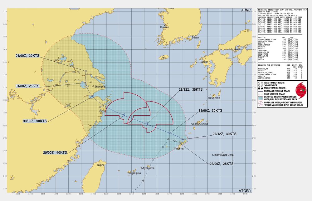
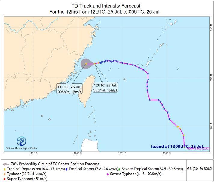
TD #Comay impacting the S #RyukyuIslands #Japan esp #Okinawa and later #Amami Islands #Kagoshima
ALL interests should finish preps now!
#Wxx #Wxtwitter #Tropicswx #BlueSkyWx #台風8号 #TyphoonComay #EmongPh #Naha #Tropicalstormcomay #TropicalStorm
ALL interests should finish preps now!
#Wxx #Wxtwitter #Tropicswx #BlueSkyWx #台風8号 #TyphoonComay #EmongPh #Naha #Tropicalstormcomay #TropicalStorm

July 26, 2025 at 3:06 PM
TD #Comay impacting the S #RyukyuIslands #Japan esp #Okinawa and later #Amami Islands #Kagoshima
ALL interests should finish preps now!
#Wxx #Wxtwitter #Tropicswx #BlueSkyWx #台風8号 #TyphoonComay #EmongPh #Naha #Tropicalstormcomay #TropicalStorm
ALL interests should finish preps now!
#Wxx #Wxtwitter #Tropicswx #BlueSkyWx #台風8号 #TyphoonComay #EmongPh #Naha #Tropicalstormcomay #TropicalStorm
Reposted by wedery
#Invest91W E of #AmamiOshima #Amami #Kagoshima #Japan forecast to move W towards E #China before recurving to #SouthKorea
All interests to monitor closely!
#Wxx #Wxtwitter #tropicswx #BlueSkywx #Bailu #91W #台風10号 #13W #Zhejiang #Shanghai #Jiangsu #Ningbo #Zhoushan #Hangzhou #Suzhou #Seoul #Incheon
All interests to monitor closely!
#Wxx #Wxtwitter #tropicswx #BlueSkywx #Bailu #91W #台風10号 #13W #Zhejiang #Shanghai #Jiangsu #Ningbo #Zhoushan #Hangzhou #Suzhou #Seoul #Incheon


July 26, 2025 at 4:04 PM
#Invest91W E of #AmamiOshima #Amami #Kagoshima #Japan forecast to move W towards E #China before recurving to #SouthKorea
All interests to monitor closely!
#Wxx #Wxtwitter #tropicswx #BlueSkywx #Bailu #91W #台風10号 #13W #Zhejiang #Shanghai #Jiangsu #Ningbo #Zhoushan #Hangzhou #Suzhou #Seoul #Incheon
All interests to monitor closely!
#Wxx #Wxtwitter #tropicswx #BlueSkywx #Bailu #91W #台風10号 #13W #Zhejiang #Shanghai #Jiangsu #Ningbo #Zhoushan #Hangzhou #Suzhou #Seoul #Incheon
Reposted by wedery
60mph #Krosa NW of #NorthernMarianaIslands #Guam to head N impacting #OgasawaraIslands of #Tokyo #Japan to peak at 80mph C1 #Typhoon
All interests in the latter to begin preparations now!
#Wxx #Wxtwitter #BlueSkyWx #TropicsWx #GUwx #CNMIwx #台風9号 #TropicalstormKrosa #TyphoonKrosa #TropicalStorm
All interests in the latter to begin preparations now!
#Wxx #Wxtwitter #BlueSkyWx #TropicsWx #GUwx #CNMIwx #台風9号 #TropicalstormKrosa #TyphoonKrosa #TropicalStorm

July 26, 2025 at 3:49 AM
60mph #Krosa NW of #NorthernMarianaIslands #Guam to head N impacting #OgasawaraIslands of #Tokyo #Japan to peak at 80mph C1 #Typhoon
All interests in the latter to begin preparations now!
#Wxx #Wxtwitter #BlueSkyWx #TropicsWx #GUwx #CNMIwx #台風9号 #TropicalstormKrosa #TyphoonKrosa #TropicalStorm
All interests in the latter to begin preparations now!
#Wxx #Wxtwitter #BlueSkyWx #TropicsWx #GUwx #CNMIwx #台風9号 #TropicalstormKrosa #TyphoonKrosa #TropicalStorm
Reposted by wedery
TD #Comay impacting the S #RyukyuIslands #Japan esp #Ishigaki #Miyakojima #iriomote #Okinawa
ALL interests should finish preps now!
#Wxx #Wxtwitter #Tropicswx #BlueSkyWx #台風8号 #TyphoonComay #EmongPh #Naha #Tropicalstormcomay #TropicalStorm
ALL interests should finish preps now!
#Wxx #Wxtwitter #Tropicswx #BlueSkyWx #台風8号 #TyphoonComay #EmongPh #Naha #Tropicalstormcomay #TropicalStorm

July 26, 2025 at 3:49 AM
TD #Comay impacting the S #RyukyuIslands #Japan esp #Ishigaki #Miyakojima #iriomote #Okinawa
ALL interests should finish preps now!
#Wxx #Wxtwitter #Tropicswx #BlueSkyWx #台風8号 #TyphoonComay #EmongPh #Naha #Tropicalstormcomay #TropicalStorm
ALL interests should finish preps now!
#Wxx #Wxtwitter #Tropicswx #BlueSkyWx #台風8号 #TyphoonComay #EmongPh #Naha #Tropicalstormcomay #TropicalStorm
We’ve also revised Man-yi / Pepito’s peak from 205 km/h & 920 hPa to 215 km/h & 915 hPa, putting it in Extreme Typhoon (Category 5 High) territory on our scale.
You can find this in the Cyclone Archive, with even more details coming with v2.2. Thanks for waiting!
You can find this in the Cyclone Archive, with even more details coming with v2.2. Thanks for waiting!
We've started publishing our estimates for 2024 WNP storms that weren't recorded in our Cyclone Archive. Some of these include:
- Ewiniar / Aghon
- Carina / Gaemi
- Krathon / Julian
...among others.
More info here: wedery.pages.dev/tools/cyclon...
- Ewiniar / Aghon
- Carina / Gaemi
- Krathon / Julian
...among others.
More info here: wedery.pages.dev/tools/cyclon...
wedery.pages.dev
July 25, 2025 at 5:59 PM
We’ve also revised Man-yi / Pepito’s peak from 205 km/h & 920 hPa to 215 km/h & 915 hPa, putting it in Extreme Typhoon (Category 5 High) territory on our scale.
You can find this in the Cyclone Archive, with even more details coming with v2.2. Thanks for waiting!
You can find this in the Cyclone Archive, with even more details coming with v2.2. Thanks for waiting!
We've started publishing our estimates for 2024 WNP storms that weren't recorded in our Cyclone Archive. Some of these include:
- Ewiniar / Aghon
- Carina / Gaemi
- Krathon / Julian
...among others.
More info here: wedery.pages.dev/tools/cyclon...
- Ewiniar / Aghon
- Carina / Gaemi
- Krathon / Julian
...among others.
More info here: wedery.pages.dev/tools/cyclon...
wedery.pages.dev
July 25, 2025 at 5:56 PM
We've started publishing our estimates for 2024 WNP storms that weren't recorded in our Cyclone Archive. Some of these include:
- Ewiniar / Aghon
- Carina / Gaemi
- Krathon / Julian
...among others.
More info here: wedery.pages.dev/tools/cyclon...
- Ewiniar / Aghon
- Carina / Gaemi
- Krathon / Julian
...among others.
More info here: wedery.pages.dev/tools/cyclon...
Reposted by wedery
45mph #Krosa NW of #NorthernMarianaIslands #Guam to head N impacting #OgasawaraIslands of #Tokyo #Japan to peak at 75mph C1 #Typhoon
All interests in the latter to begin preparations now!
#Wxx #Wxtwitter #BlueSkyWx #TropicsWx #GUwx #CNMIwx #台風9号 #TropicalstormKrosa #TyphoonKrosa #TropicalStorm
All interests in the latter to begin preparations now!
#Wxx #Wxtwitter #BlueSkyWx #TropicsWx #GUwx #CNMIwx #台風9号 #TropicalstormKrosa #TyphoonKrosa #TropicalStorm


July 25, 2025 at 1:52 PM
45mph #Krosa NW of #NorthernMarianaIslands #Guam to head N impacting #OgasawaraIslands of #Tokyo #Japan to peak at 75mph C1 #Typhoon
All interests in the latter to begin preparations now!
#Wxx #Wxtwitter #BlueSkyWx #TropicsWx #GUwx #CNMIwx #台風9号 #TropicalstormKrosa #TyphoonKrosa #TropicalStorm
All interests in the latter to begin preparations now!
#Wxx #Wxtwitter #BlueSkyWx #TropicsWx #GUwx #CNMIwx #台風9号 #TropicalstormKrosa #TyphoonKrosa #TropicalStorm
Reposted by wedery
#Francisco a TD nearing E #China esp S #zhejiang N #Fujian
ALL Interests there to prepare for possible life threatening heavy #Flooding Rains and #Mudslides!
#Wxx #Wxtwitter #TropicsWx #BlueSkyWx #TropicalStormFrancisco #台風7号 #Wenzhou #Ningde #DantePH #TropicalStorm
ALL Interests there to prepare for possible life threatening heavy #Flooding Rains and #Mudslides!
#Wxx #Wxtwitter #TropicsWx #BlueSkyWx #TropicalStormFrancisco #台風7号 #Wenzhou #Ningde #DantePH #TropicalStorm

July 25, 2025 at 2:42 PM
#Francisco a TD nearing E #China esp S #zhejiang N #Fujian
ALL Interests there to prepare for possible life threatening heavy #Flooding Rains and #Mudslides!
#Wxx #Wxtwitter #TropicsWx #BlueSkyWx #TropicalStormFrancisco #台風7号 #Wenzhou #Ningde #DantePH #TropicalStorm
ALL Interests there to prepare for possible life threatening heavy #Flooding Rains and #Mudslides!
#Wxx #Wxtwitter #TropicsWx #BlueSkyWx #TropicalStormFrancisco #台風7号 #Wenzhou #Ningde #DantePH #TropicalStorm
Reposted by wedery
#Comay E of #Batanes #Philippines now a 40mph #TropicalStorm forecast to weaken approaching #RyukyuIslands #Japan esp #Ishigaki #Miyakojima #iriomote #Okinawa
ALL interests should finish preps now!
#Wxx #Wxtwitter #Tropicswx #BlueSkyWx #台風8号 #TyphoonComay #EmongPh #Naha #Tropicalstormcomay
ALL interests should finish preps now!
#Wxx #Wxtwitter #Tropicswx #BlueSkyWx #台風8号 #TyphoonComay #EmongPh #Naha #Tropicalstormcomay


July 25, 2025 at 2:44 PM
#Comay E of #Batanes #Philippines now a 40mph #TropicalStorm forecast to weaken approaching #RyukyuIslands #Japan esp #Ishigaki #Miyakojima #iriomote #Okinawa
ALL interests should finish preps now!
#Wxx #Wxtwitter #Tropicswx #BlueSkyWx #台風8号 #TyphoonComay #EmongPh #Naha #Tropicalstormcomay
ALL interests should finish preps now!
#Wxx #Wxtwitter #Tropicswx #BlueSkyWx #台風8号 #TyphoonComay #EmongPh #Naha #Tropicalstormcomay
Reposted by wedery
#Comay off NW #Luzon 's #IlocosNorte as a 50mph #TropicalStorm forecast to weaken approaching #RyukyuIslands #Japan esp #Ishigaki #Miyakojima #iriomote #Okinawa
ALL interests should finish preps now!
#Wxx #Wxtwitter #Tropicswx #BlueSkyWx #台風8号 #TyphoonComay #EmongPh #Naha #Tropicalstormcomay
ALL interests should finish preps now!
#Wxx #Wxtwitter #Tropicswx #BlueSkyWx #台風8号 #TyphoonComay #EmongPh #Naha #Tropicalstormcomay


July 25, 2025 at 8:09 AM
#Comay off NW #Luzon 's #IlocosNorte as a 50mph #TropicalStorm forecast to weaken approaching #RyukyuIslands #Japan esp #Ishigaki #Miyakojima #iriomote #Okinawa
ALL interests should finish preps now!
#Wxx #Wxtwitter #Tropicswx #BlueSkyWx #台風8号 #TyphoonComay #EmongPh #Naha #Tropicalstormcomay
ALL interests should finish preps now!
#Wxx #Wxtwitter #Tropicswx #BlueSkyWx #台風8号 #TyphoonComay #EmongPh #Naha #Tropicalstormcomay
Reposted by wedery
45mph #Krosa NW of #NorthernMarianaIslands #Guam to head N impacting #OgasawaraIslands of #Tokyo #Japan to peak at 75mph C1 #Typhoon
All interests in the latter to begin preparations now!
#Wxx #Wxtwitter #BlueSkyWx #TropicsWx #GUwx #CNMIwx #台風9号 #TropicalstormKrosa #TyphoonKrosa #TropicalStorm
All interests in the latter to begin preparations now!
#Wxx #Wxtwitter #BlueSkyWx #TropicsWx #GUwx #CNMIwx #台風9号 #TropicalstormKrosa #TyphoonKrosa #TropicalStorm


July 25, 2025 at 8:17 AM
45mph #Krosa NW of #NorthernMarianaIslands #Guam to head N impacting #OgasawaraIslands of #Tokyo #Japan to peak at 75mph C1 #Typhoon
All interests in the latter to begin preparations now!
#Wxx #Wxtwitter #BlueSkyWx #TropicsWx #GUwx #CNMIwx #台風9号 #TropicalstormKrosa #TyphoonKrosa #TropicalStorm
All interests in the latter to begin preparations now!
#Wxx #Wxtwitter #BlueSkyWx #TropicsWx #GUwx #CNMIwx #台風9号 #TropicalstormKrosa #TyphoonKrosa #TropicalStorm
Reposted by wedery
#Francisco after S #RyukyuIslands #Japan no longer #tropicalstorm nearing E #China esp S #zhejiang N #Fujian
ALL Interests in the latter and N #Taiwan to watch closely
#Wxx #Wxtwitter #TropicsWx #BlueSkyWx #TropicalStormFrancisco #台風7号 #Wenzhou #Ningde #DantePH #Taipei #Keelung
ALL Interests in the latter and N #Taiwan to watch closely
#Wxx #Wxtwitter #TropicsWx #BlueSkyWx #TropicalStormFrancisco #台風7号 #Wenzhou #Ningde #DantePH #Taipei #Keelung


July 25, 2025 at 8:58 AM
#Francisco after S #RyukyuIslands #Japan no longer #tropicalstorm nearing E #China esp S #zhejiang N #Fujian
ALL Interests in the latter and N #Taiwan to watch closely
#Wxx #Wxtwitter #TropicsWx #BlueSkyWx #TropicalStormFrancisco #台風7号 #Wenzhou #Ningde #DantePH #Taipei #Keelung
ALL Interests in the latter and N #Taiwan to watch closely
#Wxx #Wxtwitter #TropicsWx #BlueSkyWx #TropicalStormFrancisco #台風7号 #Wenzhou #Ningde #DantePH #Taipei #Keelung
Reposted by wedery
#Comay landfalls near #Vigan #IlocosSur N #Luzon at 70mph #TropicalStorm now down to 50mph on land while weakening to #RyukyuIslands #Japan esp #Ishigaki #Miyakojima #Okinawa
ALL interests should finish preps now!
#Wxx #Wxtwitter #Tropicswx #BlueSkyWx #台風8号 #TyphoonComay #EmongPh #Naha #Vigan
ALL interests should finish preps now!
#Wxx #Wxtwitter #Tropicswx #BlueSkyWx #台風8号 #TyphoonComay #EmongPh #Naha #Vigan


July 25, 2025 at 2:27 AM
#Comay landfalls near #Vigan #IlocosSur N #Luzon at 70mph #TropicalStorm now down to 50mph on land while weakening to #RyukyuIslands #Japan esp #Ishigaki #Miyakojima #Okinawa
ALL interests should finish preps now!
#Wxx #Wxtwitter #Tropicswx #BlueSkyWx #台風8号 #TyphoonComay #EmongPh #Naha #Vigan
ALL interests should finish preps now!
#Wxx #Wxtwitter #Tropicswx #BlueSkyWx #台風8号 #TyphoonComay #EmongPh #Naha #Vigan
Reposted by wedery
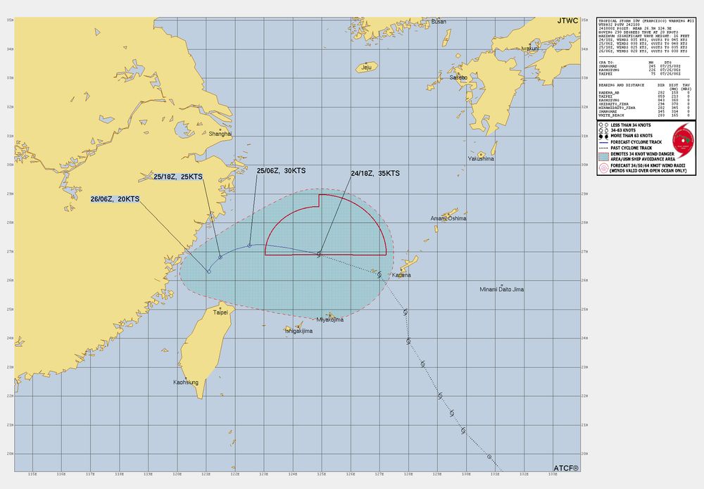
40mph #TropicalStorm #Francisco after impacting S #RyukyuIslands #Japan to head to E #China esp S #zhejiang N #Fujian
ALL Interests there N #Taiwan to watch closely
#Wxx #Wxtwitter #TropicsWx #BlueSkyWx #TropicalStormFrancisco #台風7号 #Wenzhou #Ningde #DantePH #Taipei #Keelung
ALL Interests there N #Taiwan to watch closely
#Wxx #Wxtwitter #TropicsWx #BlueSkyWx #TropicalStormFrancisco #台風7号 #Wenzhou #Ningde #DantePH #Taipei #Keelung


July 25, 2025 at 2:36 AM
40mph #TropicalStorm #Francisco after impacting S #RyukyuIslands #Japan to head to E #China esp S #zhejiang N #Fujian
ALL Interests there N #Taiwan to watch closely
#Wxx #Wxtwitter #TropicsWx #BlueSkyWx #TropicalStormFrancisco #台風7号 #Wenzhou #Ningde #DantePH #Taipei #Keelung
ALL Interests there N #Taiwan to watch closely
#Wxx #Wxtwitter #TropicsWx #BlueSkyWx #TropicalStormFrancisco #台風7号 #Wenzhou #Ningde #DantePH #Taipei #Keelung
Reposted by wedery
45mph #Krosa NW of #NorthernMarianaIslands #Guam to head N impacting #OgasawaraIslands of #Tokyo #Japan to peak at 75mph C1 #Typhoon
All interests in the latter to begin preparations now!
#Wxx #Wxtwitter #BlueSkyWx #TropicsWx #GUwx #CNMIwx #台風9号 #TropicalstormKrosa #TyphoonKrosa #TropicalStorm
All interests in the latter to begin preparations now!
#Wxx #Wxtwitter #BlueSkyWx #TropicsWx #GUwx #CNMIwx #台風9号 #TropicalstormKrosa #TyphoonKrosa #TropicalStorm


July 25, 2025 at 3:04 AM
45mph #Krosa NW of #NorthernMarianaIslands #Guam to head N impacting #OgasawaraIslands of #Tokyo #Japan to peak at 75mph C1 #Typhoon
All interests in the latter to begin preparations now!
#Wxx #Wxtwitter #BlueSkyWx #TropicsWx #GUwx #CNMIwx #台風9号 #TropicalstormKrosa #TyphoonKrosa #TropicalStorm
All interests in the latter to begin preparations now!
#Wxx #Wxtwitter #BlueSkyWx #TropicsWx #GUwx #CNMIwx #台風9号 #TropicalstormKrosa #TyphoonKrosa #TropicalStorm
Reposted by wedery
#Comay near N #Philippines now 75mph C1 #Typhoon to hit #IlocosSur N #Luzon at this intensity heading NE while weakening to #RyukyuIslands #Japan esp #Ishigaki #Miyakojima #Okinawa
ALL interests should finish preps now!
#Wxx #Wxtwitter #Tropicswx #BlueSkyWx #台風8号 #TyphoonComay #EmongPh #Naha #Vigan
ALL interests should finish preps now!
#Wxx #Wxtwitter #Tropicswx #BlueSkyWx #台風8号 #TyphoonComay #EmongPh #Naha #Vigan


July 24, 2025 at 3:07 PM
#Comay near N #Philippines now 75mph C1 #Typhoon to hit #IlocosSur N #Luzon at this intensity heading NE while weakening to #RyukyuIslands #Japan esp #Ishigaki #Miyakojima #Okinawa
ALL interests should finish preps now!
#Wxx #Wxtwitter #Tropicswx #BlueSkyWx #台風8号 #TyphoonComay #EmongPh #Naha #Vigan
ALL interests should finish preps now!
#Wxx #Wxtwitter #Tropicswx #BlueSkyWx #台風8号 #TyphoonComay #EmongPh #Naha #Vigan
Reposted by wedery
#Krosa NW of #NorthernMarianaIslands #Guam to head N impacting #OgasawaraIslands of #Tokyo #Japan to peak at 70mph #Tropicalstorm or even #Typhoon
All interests in the latter to begin preparations now!
#Wxx #Wxtwitter #BlueSkyWx #TropicsWx #GUwx #CNMIwx #台風9号 #TropicalstormKrosa #TyphoonKrosa
All interests in the latter to begin preparations now!
#Wxx #Wxtwitter #BlueSkyWx #TropicsWx #GUwx #CNMIwx #台風9号 #TropicalstormKrosa #TyphoonKrosa


July 24, 2025 at 3:10 PM
#Krosa NW of #NorthernMarianaIslands #Guam to head N impacting #OgasawaraIslands of #Tokyo #Japan to peak at 70mph #Tropicalstorm or even #Typhoon
All interests in the latter to begin preparations now!
#Wxx #Wxtwitter #BlueSkyWx #TropicsWx #GUwx #CNMIwx #台風9号 #TropicalstormKrosa #TyphoonKrosa
All interests in the latter to begin preparations now!
#Wxx #Wxtwitter #BlueSkyWx #TropicsWx #GUwx #CNMIwx #台風9号 #TropicalstormKrosa #TyphoonKrosa
Reposted by wedery
40mph #TropicalStorm #Francisco to peak now and head NW to S #RyukyuIslands #Japan and E #China esp #zhejiang N #Fujian
ALL Interests there N #Taiwan to watch closely
#Wxx #Wxtwitter #TropicsWx #BlueSkyWx #TropicalStormFrancisco #台風7号 #Wenzhou #Naha #Okinawa #Ningde #DantePH #Taipei #Keelung
ALL Interests there N #Taiwan to watch closely
#Wxx #Wxtwitter #TropicsWx #BlueSkyWx #TropicalStormFrancisco #台風7号 #Wenzhou #Naha #Okinawa #Ningde #DantePH #Taipei #Keelung


July 24, 2025 at 3:11 PM
40mph #TropicalStorm #Francisco to peak now and head NW to S #RyukyuIslands #Japan and E #China esp #zhejiang N #Fujian
ALL Interests there N #Taiwan to watch closely
#Wxx #Wxtwitter #TropicsWx #BlueSkyWx #TropicalStormFrancisco #台風7号 #Wenzhou #Naha #Okinawa #Ningde #DantePH #Taipei #Keelung
ALL Interests there N #Taiwan to watch closely
#Wxx #Wxtwitter #TropicsWx #BlueSkyWx #TropicalStormFrancisco #台風7号 #Wenzhou #Naha #Okinawa #Ningde #DantePH #Taipei #Keelung
Reposted by wedery
Signal 4: SW #IlocosSur W #Pangasinan W #LaUnion
1/2/3: rest of N #Luzon incl #BabuyanIslands #Batanes #Isabela #Cagayan #Abra #Ifugao #Apayao #MountainProvince
#Wxx #Wxtwitter #Tropicswx #BlueSkyWx #台風8号 #Comay #TropicalStorm #TropicalStormComay #EmongPH #Philippines #TyphoonComay #Typhoon
1/2/3: rest of N #Luzon incl #BabuyanIslands #Batanes #Isabela #Cagayan #Abra #Ifugao #Apayao #MountainProvince
#Wxx #Wxtwitter #Tropicswx #BlueSkyWx #台風8号 #Comay #TropicalStorm #TropicalStormComay #EmongPH #Philippines #TyphoonComay #Typhoon

July 24, 2025 at 3:35 PM
Signal 4: SW #IlocosSur W #Pangasinan W #LaUnion
1/2/3: rest of N #Luzon incl #BabuyanIslands #Batanes #Isabela #Cagayan #Abra #Ifugao #Apayao #MountainProvince
#Wxx #Wxtwitter #Tropicswx #BlueSkyWx #台風8号 #Comay #TropicalStorm #TropicalStormComay #EmongPH #Philippines #TyphoonComay #Typhoon
1/2/3: rest of N #Luzon incl #BabuyanIslands #Batanes #Isabela #Cagayan #Abra #Ifugao #Apayao #MountainProvince
#Wxx #Wxtwitter #Tropicswx #BlueSkyWx #台風8号 #Comay #TropicalStorm #TropicalStormComay #EmongPH #Philippines #TyphoonComay #Typhoon