


terence
@tterence.bsky.social
smitten with #rstats · associate prof · political economy · the #rayverse's number one fan

Freshwater ecoregions of South America.
But why didn't you do this in #rayshader?! Of course I did, but am still sorting out a few issues because rivers don't fall neatly into categories...
#ggplot2 adventures, an #rstats tale
But why didn't you do this in #rayshader?! Of course I did, but am still sorting out a few issues because rivers don't fall neatly into categories...
#ggplot2 adventures, an #rstats tale

January 23, 2026 at 6:45 PM
Freshwater ecoregions of South America.
But why didn't you do this in #rayshader?! Of course I did, but am still sorting out a few issues because rivers don't fall neatly into categories...
#ggplot2 adventures, an #rstats tale
But why didn't you do this in #rayshader?! Of course I did, but am still sorting out a few issues because rivers don't fall neatly into categories...
#ggplot2 adventures, an #rstats tale

Nine volcanoes of Japan. Mt. Fuji is instantly recognisable. The others too, I hope.
This took a while to get right. Looks like fancy chocolates, no? Or little LED buttons.
#rayshader adventures, an #rstats tale
This took a while to get right. Looks like fancy chocolates, no? Or little LED buttons.
#rayshader adventures, an #rstats tale

January 17, 2026 at 1:17 AM
Nine volcanoes of Japan. Mt. Fuji is instantly recognisable. The others too, I hope.
This took a while to get right. Looks like fancy chocolates, no? Or little LED buttons.
#rayshader adventures, an #rstats tale
This took a while to get right. Looks like fancy chocolates, no? Or little LED buttons.
#rayshader adventures, an #rstats tale
Back to ski runs. I liked @infowetrust.com's suggestion and got to work but was frustrated by label size and placement.
So I made it interactive, two ways. Which do you prefer?
tterence.shinyapps.io/hunter_mount...
tterence.shinyapps.io/hunter_mount...
#shiny adventures, an #rstats tale
So I made it interactive, two ways. Which do you prefer?
tterence.shinyapps.io/hunter_mount...
tterence.shinyapps.io/hunter_mount...
#shiny adventures, an #rstats tale

tterence.shinyapps.io
January 16, 2026 at 8:38 PM
Back to ski runs. I liked @infowetrust.com's suggestion and got to work but was frustrated by label size and placement.
So I made it interactive, two ways. Which do you prefer?
tterence.shinyapps.io/hunter_mount...
tterence.shinyapps.io/hunter_mount...
#shiny adventures, an #rstats tale
So I made it interactive, two ways. Which do you prefer?
tterence.shinyapps.io/hunter_mount...
tterence.shinyapps.io/hunter_mount...
#shiny adventures, an #rstats tale

January 16, 2026 at 1:54 PM

Visualising ski run elevation profiles of Hunter Mountain.
Thoughts? I tried facetting them by difficulty but they'd look either too wide or tall. Is it useful, interesting? Might be worth combining with an isometric view (in rayshader).
#ggplot2 adventures, an #rstats tale
Thoughts? I tried facetting them by difficulty but they'd look either too wide or tall. Is it useful, interesting? Might be worth combining with an isometric view (in rayshader).
#ggplot2 adventures, an #rstats tale

January 15, 2026 at 3:29 AM


January 10, 2026 at 2:42 PM
Trying something different with Mount Snow in neon.
Am of two minds about the light reflections...maybe microfacet is better.
#rayshader adventures, an #rstats tale
Am of two minds about the light reflections...maybe microfacet is better.
#rayshader adventures, an #rstats tale

January 9, 2026 at 4:34 PM
Trying something different with Mount Snow in neon.
Am of two minds about the light reflections...maybe microfacet is better.
#rayshader adventures, an #rstats tale
Am of two minds about the light reflections...maybe microfacet is better.
#rayshader adventures, an #rstats tale
This was supposed to be a draft render. Just a quick `render_highquality()` with no additional arguments. Is it me or does it already look pretty good?
#rayshader adventures, an #rstats tale
#rayshader adventures, an #rstats tale

January 9, 2026 at 3:52 AM
This was supposed to be a draft render. Just a quick `render_highquality()` with no additional arguments. Is it me or does it already look pretty good?
#rayshader adventures, an #rstats tale
#rayshader adventures, an #rstats tale
That's it. I have had enough of `rgl::rglwidget()`.
Time to revert to Sequoia.
Time to revert to Sequoia.
January 8, 2026 at 4:10 PM
That's it. I have had enough of `rgl::rglwidget()`.
Time to revert to Sequoia.
Time to revert to Sequoia.

January 8, 2026 at 2:37 PM
Found the code to do this strange attractor while looking for something else. Thought I'd see how fast I can render 360 frames of this with denoising.
What used to take hours now takes slightly more than 60 minutes.
#rayrender adventures, an #rstats tale
What used to take hours now takes slightly more than 60 minutes.
#rayrender adventures, an #rstats tale
January 8, 2026 at 1:46 PM
Found the code to do this strange attractor while looking for something else. Thought I'd see how fast I can render 360 frames of this with denoising.
What used to take hours now takes slightly more than 60 minutes.
#rayrender adventures, an #rstats tale
What used to take hours now takes slightly more than 60 minutes.
#rayrender adventures, an #rstats tale
Reposted by terence

poisonfrogs: Color Palettes Inspired by Neotropical Poison Frogs laurenoconnelllab.github.io/poisonfrogs/ #Rstats


January 7, 2026 at 3:00 PM
poisonfrogs: Color Palettes Inspired by Neotropical Poison Frogs laurenoconnelllab.github.io/poisonfrogs/ #Rstats
Power lines of Germany revisited, this time showing both OSM and derived power lines.
Should have done this from the start but was afraid it'd take too long to render this many lines. Guess not! :)
#rayshader adventures, an #rstats tale
Should have done this from the start but was afraid it'd take too long to render this many lines. Guess not! :)
#rayshader adventures, an #rstats tale

January 7, 2026 at 12:41 PM
Power lines of Germany revisited, this time showing both OSM and derived power lines.
Should have done this from the start but was afraid it'd take too long to render this many lines. Guess not! :)
#rayshader adventures, an #rstats tale
Should have done this from the start but was afraid it'd take too long to render this many lines. Guess not! :)
#rayshader adventures, an #rstats tale

January 6, 2026 at 1:40 PM

December 22, 2025 at 11:49 PM

December 22, 2025 at 12:07 AM
Ships of the Gulf of México. Thought I'd try to overlay all of them on one viz this time. Probably clearer if I split them up, no?
#rayshader adventures, an #rstats tale
#rayshader adventures, an #rstats tale

December 5, 2025 at 2:15 AM
Ships of the Gulf of México. Thought I'd try to overlay all of them on one viz this time. Probably clearer if I split them up, no?
#rayshader adventures, an #rstats tale
#rayshader adventures, an #rstats tale
I can now paint with #rayshader. This is with a mere ten samples.
#rayshader adventures, an #rstats tale
#rayshader adventures, an #rstats tale

December 5, 2025 at 1:14 AM
I can now paint with #rayshader. This is with a mere ten samples.
#rayshader adventures, an #rstats tale
#rayshader adventures, an #rstats tale

December 4, 2025 at 4:06 PM
Reposted by terence

R: the language that sets the gold standard for dataviz!
Anonymous user K. Midas says: "I love it!"
(from a cheeky #rayshader figure in an upcoming blog post about rendering 3D plots with "golden hour" lighting by generating synthetic sunsets, entirely in #RStats with #rayrender)
Anonymous user K. Midas says: "I love it!"
(from a cheeky #rayshader figure in an upcoming blog post about rendering 3D plots with "golden hour" lighting by generating synthetic sunsets, entirely in #RStats with #rayrender)
December 2, 2025 at 12:41 PM
R: the language that sets the gold standard for dataviz!
Anonymous user K. Midas says: "I love it!"
(from a cheeky #rayshader figure in an upcoming blog post about rendering 3D plots with "golden hour" lighting by generating synthetic sunsets, entirely in #RStats with #rayrender)
Anonymous user K. Midas says: "I love it!"
(from a cheeky #rayshader figure in an upcoming blog post about rendering 3D plots with "golden hour" lighting by generating synthetic sunsets, entirely in #RStats with #rayrender)
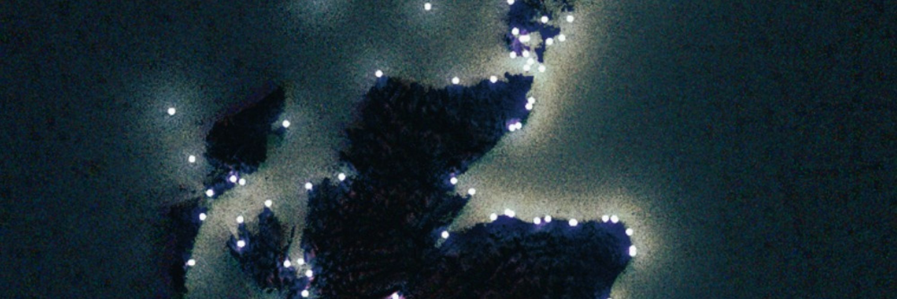
This lo-res, firefly-ridden render of Brasil's power transmission lines (osm and derived) took hours. Turns out even with Tyler's amazing optimizations, I can still bring the rendering process to a crawl. To be fair, it's over 150k lines.
#rayshader adventures, an #rstats tale
#rayshader adventures, an #rstats tale

November 27, 2025 at 1:39 AM
This lo-res, firefly-ridden render of Brasil's power transmission lines (osm and derived) took hours. Turns out even with Tyler's amazing optimizations, I can still bring the rendering process to a crawl. To be fair, it's over 150k lines.
#rayshader adventures, an #rstats tale
#rayshader adventures, an #rstats tale