


SW Louisiana Weather
@swlaweathernow.bsky.social
Covering the weather for Southwest Louisiana and Acadiana. Weather you can count on. Find our other platforms here: https://linktr.ee/swlouisianaweather | Owner @masoncwx
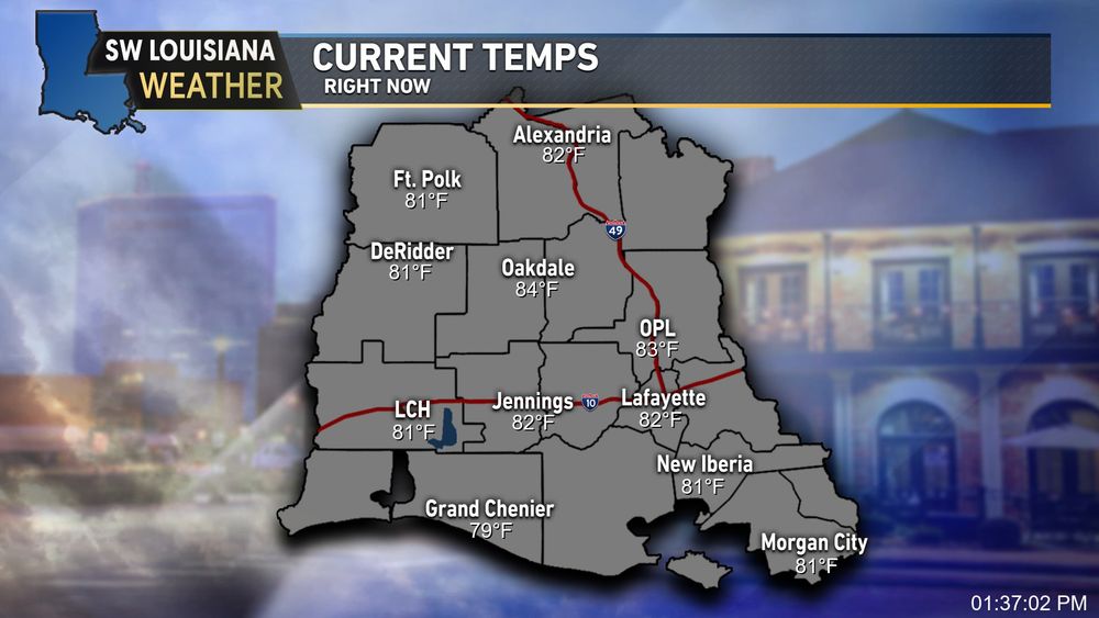
Even with temps in the low 80s and mostly clear skies, it's a beautiful calm day across the region. Winds are light and should stay that way a few more days. Some active weather possible late week.. we’ll be watching. Tropics? Quiet for now. Enjoy the low humidity! #LAwx


May 31, 2025 at 5:45 PM
Even with temps in the low 80s and mostly clear skies, it's a beautiful calm day across the region. Winds are light and should stay that way a few more days. Some active weather possible late week.. we’ll be watching. Tropics? Quiet for now. Enjoy the low humidity! #LAwx
Final rain totals from 5/6–5/7: Some spots saw enough to trigger major flash flooding, esp. in Beauregard, Allen & Calcasieu. Data pulled from CPPJ gauges, PWS, & METARs. More rain possible tomorrow/weekend, but not expecting major flood issues. #LAwx

May 8, 2025 at 3:38 AM
Final rain totals from 5/6–5/7: Some spots saw enough to trigger major flash flooding, esp. in Beauregard, Allen & Calcasieu. Data pulled from CPPJ gauges, PWS, & METARs. More rain possible tomorrow/weekend, but not expecting major flood issues. #LAwx
Light winds overnight, but we could see gusts over 20mph tomorrow ahead of a cold front for your Sat. A few strong to severe storms aren't off the table either. We’ll have a better handle on those details by tomorrow, so stay tuned and have a good night #lawx

May 2, 2025 at 4:00 AM
Light winds overnight, but we could see gusts over 20mph tomorrow ahead of a cold front for your Sat. A few strong to severe storms aren't off the table either. We’ll have a better handle on those details by tomorrow, so stay tuned and have a good night #lawx
Overnight strong storms possible (4/30–5/1):
Line moves in 12–3AM north, 2–5AM Acadiana/SWLA.
Most will just see rain & 40–50mph gusts, but IF it holds, pockets of 70+mph wind & hail possible. Tornado/flood risk low. Charge phones & multiple ways to get warnings tonight. #lawx
Line moves in 12–3AM north, 2–5AM Acadiana/SWLA.
Most will just see rain & 40–50mph gusts, but IF it holds, pockets of 70+mph wind & hail possible. Tornado/flood risk low. Charge phones & multiple ways to get warnings tonight. #lawx

May 1, 2025 at 12:03 AM
Overnight strong storms possible (4/30–5/1):
Line moves in 12–3AM north, 2–5AM Acadiana/SWLA.
Most will just see rain & 40–50mph gusts, but IF it holds, pockets of 70+mph wind & hail possible. Tornado/flood risk low. Charge phones & multiple ways to get warnings tonight. #lawx
Line moves in 12–3AM north, 2–5AM Acadiana/SWLA.
Most will just see rain & 40–50mph gusts, but IF it holds, pockets of 70+mph wind & hail possible. Tornado/flood risk low. Charge phones & multiple ways to get warnings tonight. #lawx
Hot & Muggy Is the Story...
Temps are sitting in the low to mid 80s across #southwestlouisiana and #acadiana this afternoon—and with those high dew points, it’s feeling every bit of it.
Cool weather is back on the way tho for the start of our work week!
Temps are sitting in the low to mid 80s across #southwestlouisiana and #acadiana this afternoon—and with those high dew points, it’s feeling every bit of it.
Cool weather is back on the way tho for the start of our work week!
April 5, 2025 at 6:49 PM
Hot & Muggy Is the Story...
Temps are sitting in the low to mid 80s across #southwestlouisiana and #acadiana this afternoon—and with those high dew points, it’s feeling every bit of it.
Cool weather is back on the way tho for the start of our work week!
Temps are sitting in the low to mid 80s across #southwestlouisiana and #acadiana this afternoon—and with those high dew points, it’s feeling every bit of it.
Cool weather is back on the way tho for the start of our work week!
The Front is Out.. Now What?
We’ve flipped from record snow & cold to a much milder start to Feb. Highs in the 70s this weekend, then pushing near 80° next week. Some clouds & spotty rain, but overall spring-like. That said, it's still Feb and patterns can flip fast. Stay tuned! #LAwx
We’ve flipped from record snow & cold to a much milder start to Feb. Highs in the 70s this weekend, then pushing near 80° next week. Some clouds & spotty rain, but overall spring-like. That said, it's still Feb and patterns can flip fast. Stay tuned! #LAwx

February 1, 2025 at 5:46 AM
The Front is Out.. Now What?
We’ve flipped from record snow & cold to a much milder start to Feb. Highs in the 70s this weekend, then pushing near 80° next week. Some clouds & spotty rain, but overall spring-like. That said, it's still Feb and patterns can flip fast. Stay tuned! #LAwx
We’ve flipped from record snow & cold to a much milder start to Feb. Highs in the 70s this weekend, then pushing near 80° next week. Some clouds & spotty rain, but overall spring-like. That said, it's still Feb and patterns can flip fast. Stay tuned! #LAwx
Watching Back-to-Back Fronts
Clear skies stick around until Thursday afternoon with cold mornings and warm afternoons. Low rain chances Tuesday and Thursday as fronts approach. By Friday, expect much colder weather to settle in. Stay tuned! #LAwx
Clear skies stick around until Thursday afternoon with cold mornings and warm afternoons. Low rain chances Tuesday and Thursday as fronts approach. By Friday, expect much colder weather to settle in. Stay tuned! #LAwx

November 24, 2024 at 3:08 AM
Watching Back-to-Back Fronts
Clear skies stick around until Thursday afternoon with cold mornings and warm afternoons. Low rain chances Tuesday and Thursday as fronts approach. By Friday, expect much colder weather to settle in. Stay tuned! #LAwx
Clear skies stick around until Thursday afternoon with cold mornings and warm afternoons. Low rain chances Tuesday and Thursday as fronts approach. By Friday, expect much colder weather to settle in. Stay tuned! #LAwx
Finally seeing some much-needed rain on radar. Models hint at more fronts bringing rain our way. Over the past few days, we’ve had 1-3" across most areas, with some bands seeing 4-7"+, and isolated spots over 9"! Expect this trend to continue into next week ahead of the next front. #lawx

November 7, 2024 at 2:33 AM
Finally seeing some much-needed rain on radar. Models hint at more fronts bringing rain our way. Over the past few days, we’ve had 1-3" across most areas, with some bands seeing 4-7"+, and isolated spots over 9"! Expect this trend to continue into next week ahead of the next front. #lawx
Weather Alert: A Flash Flood WARNING has been issued for the following parishes in Louisiana: Allen, Beauregard | until 7:15 PM CDT 10/31/24. Turn around, don't drown when encountering flooded roads. Most flood deaths occur in vehicles.

October 31, 2024 at 9:18 PM
Weather Alert: A Flash Flood WARNING has been issued for the following parishes in Louisiana: Allen, Beauregard | until 7:15 PM CDT 10/31/24. Turn around, don't drown when encountering flooded roads. Most flood deaths occur in vehicles.
Warm and somewhat pleasant for most, with fog likely tonight and tomorrow morning. Fog clears as winds pick up by Mon-Tues. By Wed, high pressure shifts east as a trough brings a front, but heavy rain looks unlikely—afternoon storms will be our main rain chances. #LAwx

October 26, 2024 at 9:14 PM
Warm and somewhat pleasant for most, with fog likely tonight and tomorrow morning. Fog clears as winds pick up by Mon-Tues. By Wed, high pressure shifts east as a trough brings a front, but heavy rain looks unlikely—afternoon storms will be our main rain chances. #LAwx
Reposted by SW Louisiana Weather
Not the best look for rain or heat on the longer-range GFS. Luckily for #lawx, the overall heights in the ridge won’t be super high, so no real blockbuster temps are expected. Seasonably cool lows and highs in the 80s are the name of the game for our 2024 October 🤷♂️

October 20, 2024 at 5:29 PM
Not the best look for rain or heat on the longer-range GFS. Luckily for #lawx, the overall heights in the ridge won’t be super high, so no real blockbuster temps are expected. Seasonably cool lows and highs in the 80s are the name of the game for our 2024 October 🤷♂️

Weather Alert: A Tornado WARNING has been issued for the following parishes in Louisiana: Cameron | until 10:00PM CDT. Tropical tornadoes are easy to spin up, so take cover now.

September 6, 2024 at 2:48 AM
Weather Alert: A Tornado WARNING has been issued for the following parishes in Louisiana: Cameron | until 10:00PM CDT. Tropical tornadoes are easy to spin up, so take cover now.
We now have 97L in the Atlantic, but that brings the question.. what can we see here? And how far will the impacts spread? Find that and more info below 👇

August 1, 2024 at 10:17 PM
We now have 97L in the Atlantic, but that brings the question.. what can we see here? And how far will the impacts spread? Find that and more info below 👇
About on track for where we should be this time of year, but it's still been a rather hot and humid day with that ridge in the area. Heat advisories are up for Acadia Parish eastward for tomorrow, so be sure to stay hydrated. #acadiana #southwestlouisiana

July 31, 2024 at 2:03 AM
About on track for where we should be this time of year, but it's still been a rather hot and humid day with that ridge in the area. Heat advisories are up for Acadia Parish eastward for tomorrow, so be sure to stay hydrated. #acadiana #southwestlouisiana
Tracking the Tropics: Updated NHC Outlook for the Atlantic Basin:
No impacts to SWLA are expected for now. Stay tuned to SWLA Weather for the latest updates on the #tropics. #acadiana #Louisiana #southwestlouisiana
No impacts to SWLA are expected for now. Stay tuned to SWLA Weather for the latest updates on the #tropics. #acadiana #Louisiana #southwestlouisiana

July 28, 2024 at 12:24 AM
Tracking the Tropics: Updated NHC Outlook for the Atlantic Basin:
No impacts to SWLA are expected for now. Stay tuned to SWLA Weather for the latest updates on the #tropics. #acadiana #Louisiana #southwestlouisiana
No impacts to SWLA are expected for now. Stay tuned to SWLA Weather for the latest updates on the #tropics. #acadiana #Louisiana #southwestlouisiana
It's been a wet day across #SouthwestLouisiana and south #lawx, but the flooding risk has remained minimal. With fast storms, we haven't picked up much rainfall, but areas with showers and thunderstorms have received a solid 2-3 inches with locally higher amounts. More below 👇

July 25, 2024 at 8:17 PM
It's been a wet day across #SouthwestLouisiana and south #lawx, but the flooding risk has remained minimal. With fast storms, we haven't picked up much rainfall, but areas with showers and thunderstorms have received a solid 2-3 inches with locally higher amounts. More below 👇
Weather Alert: A Severe T-Storm WARNING has been issued for the following parishes in Louisiana: Calcasieu | until 5:00 PM CDT. Large hail and damaging winds are all possible with this storm. Take cover now.

July 17, 2024 at 9:24 PM
Weather Alert: A Severe T-Storm WARNING has been issued for the following parishes in Louisiana: Calcasieu | until 5:00 PM CDT. Large hail and damaging winds are all possible with this storm. Take cover now.
A rather welcome sight: Cold front pushing in from the north will bring lows to the 50s in the northern states and the low 80s for a high in the southern region. The front will also act as a focus area for rain, potentially bringing some higher totals 👀

July 15, 2024 at 2:41 PM
A rather welcome sight: Cold front pushing in from the north will bring lows to the 50s in the northern states and the low 80s for a high in the southern region. The front will also act as a focus area for rain, potentially bringing some higher totals 👀
Weather Alert: A Severe T-Storm WARNING has been issued for the following parishes in Louisiana: Cameron, Jeff Davis, Acadia, Vermilion | until 3:00 PM CDT. Large hail and damaging winds are all possible with this storm.

July 11, 2024 at 7:20 PM
Weather Alert: A Severe T-Storm WARNING has been issued for the following parishes in Louisiana: Cameron, Jeff Davis, Acadia, Vermilion | until 3:00 PM CDT. Large hail and damaging winds are all possible with this storm.
Weather Alert: A Tornado WARNING has been issued for the following parishes in Louisiana: Beauregard, Vernon | until 1:30PM CDT. Tropical tornadoes are easy to spin up, so take cover now. #lawx

July 8, 2024 at 6:12 PM
Weather Alert: A Tornado WARNING has been issued for the following parishes in Louisiana: Beauregard, Vernon | until 1:30PM CDT. Tropical tornadoes are easy to spin up, so take cover now. #lawx
Just In: #hurricaneberyl has made its 3rd landfall, this time in Matagorda, #texas. More impacts to come with Beryl, so stay alert! #txwx

July 8, 2024 at 9:05 AM
Just In: #hurricaneberyl has made its 3rd landfall, this time in Matagorda, #texas. More impacts to come with Beryl, so stay alert! #txwx
Late PM Update: Beryl is still a Tropical Storm in the Gulf, and is still facing mainly dry air issues. By tomorrow afternoon, conditions should improve, allowing for potential intensification. Click below for more details on Beryl's potential impacts for us! 👇 #TropicalStormBeryl

July 7, 2024 at 4:32 AM
Late PM Update: Beryl is still a Tropical Storm in the Gulf, and is still facing mainly dry air issues. By tomorrow afternoon, conditions should improve, allowing for potential intensification. Click below for more details on Beryl's potential impacts for us! 👇 #TropicalStormBeryl
Good afternoon #southwestlouisiana and #acadiana. Beryl is in the SW Gulf, recovering from dry air and shear. Light showers but no major issues so far. Click for more details on Beryl's development and potential impacts to us in SWLA!👇

July 6, 2024 at 6:53 PM
Good afternoon #southwestlouisiana and #acadiana. Beryl is in the SW Gulf, recovering from dry air and shear. Light showers but no major issues so far. Click for more details on Beryl's development and potential impacts to us in SWLA!👇
Radar Update: As I mentioned last night, we have a cold front to our north pushing a line of storms into our area. These are expected to still be sub-severe due to the lack of wind shear; however, we could still get a fair amount of rain as it pushes through. 1/2

July 6, 2024 at 1:45 AM
Radar Update: As I mentioned last night, we have a cold front to our north pushing a line of storms into our area. These are expected to still be sub-severe due to the lack of wind shear; however, we could still get a fair amount of rain as it pushes through. 1/2