


Centralia, MO around 10 minutes ago

June 3, 2025 at 10:47 PM
Centralia, MO around 10 minutes ago
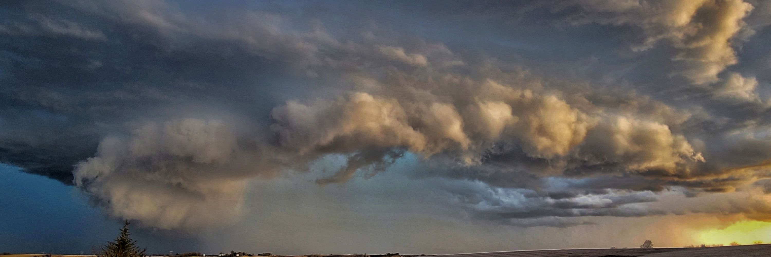
We saw what appeared to be a tornado, near Arnold, Missouri around 9:40 tonight. We are having a hard time deciding if this was a rain shaft, or an edge of the tornado. It looked fairly big on radar and had widespread power flashes.
March 15, 2025 at 6:48 AM
We saw what appeared to be a tornado, near Arnold, Missouri around 9:40 tonight. We are having a hard time deciding if this was a rain shaft, or an edge of the tornado. It looked fairly big on radar and had widespread power flashes.
Oh. Hi there Missouri

February 28, 2025 at 1:12 PM
Oh. Hi there Missouri
Severe weather potential across Arkansas looks pretty good on Tuesday so far. Gonna keep watching it for severe potential in Missouri, along a potential warm front
February 27, 2025 at 3:47 AM
Severe weather potential across Arkansas looks pretty good on Tuesday so far. Gonna keep watching it for severe potential in Missouri, along a potential warm front
NOT OFFICIAL:
Big time snow definitely looking lcortnfor parts of Western Missouri. Models progging a widespread area of 5-8 inches
Big time snow definitely looking lcortnfor parts of Western Missouri. Models progging a widespread area of 5-8 inches

February 10, 2025 at 4:47 AM
NOT OFFICIAL:
Big time snow definitely looking lcortnfor parts of Western Missouri. Models progging a widespread area of 5-8 inches
Big time snow definitely looking lcortnfor parts of Western Missouri. Models progging a widespread area of 5-8 inches
I can't wait to go to AMS and meet some new people! This will be only my second meteorology conference, and I'm also excited to see the city of New Orleans as I've never even been to Louisiana yet!
January 6, 2025 at 12:53 PM
I can't wait to go to AMS and meet some new people! This will be only my second meteorology conference, and I'm also excited to see the city of New Orleans as I've never even been to Louisiana yet!
We have a new storm coming?

January 5, 2025 at 8:20 PM
We have a new storm coming?
My forecast for tomorrow (12-28), starting at 23z!!!!
The severe weather will affect areas west of this earlier!
Pink outline: Best chance for severe weather in general
Yellow outline: best chance for tornadoes, including overnight qlcs fest
Red outline: best chance for strong tornadoes
The severe weather will affect areas west of this earlier!
Pink outline: Best chance for severe weather in general
Yellow outline: best chance for tornadoes, including overnight qlcs fest
Red outline: best chance for strong tornadoes


December 28, 2024 at 4:13 AM
My forecast for tomorrow (12-28), starting at 23z!!!!
The severe weather will affect areas west of this earlier!
Pink outline: Best chance for severe weather in general
Yellow outline: best chance for tornadoes, including overnight qlcs fest
Red outline: best chance for strong tornadoes
The severe weather will affect areas west of this earlier!
Pink outline: Best chance for severe weather in general
Yellow outline: best chance for tornadoes, including overnight qlcs fest
Red outline: best chance for strong tornadoes
A Severe weather event looks likely today across parts of the Southern U.S.
Here is a little thread with my forecast!
Here is a little thread with my forecast!
December 26, 2024 at 4:24 PM
A Severe weather event looks likely today across parts of the Southern U.S.
Here is a little thread with my forecast!
Here is a little thread with my forecast!
Here's my categorical and tornado outlook for Wednesday. I think wind will be the main threat, although tornadoes seem more likely across OK and S KS, near a meso-low that looks to develop

October 28, 2024 at 8:32 PM
Here's my categorical and tornado outlook for Wednesday. I think wind will be the main threat, although tornadoes seem more likely across OK and S KS, near a meso-low that looks to develop
My Novice Thursday Forecast:
I think severe weather is possible today across the Central Plains and Lower Mississippi Valley.
My tornado threat: 0%
My wind threat: 15%
My hail threat: 5%
I think severe weather is possible today across the Central Plains and Lower Mississippi Valley.
My tornado threat: 0%
My wind threat: 15%
My hail threat: 5%

October 24, 2024 at 6:50 PM
My Novice Thursday Forecast:
I think severe weather is possible today across the Central Plains and Lower Mississippi Valley.
My tornado threat: 0%
My wind threat: 15%
My hail threat: 5%
I think severe weather is possible today across the Central Plains and Lower Mississippi Valley.
My tornado threat: 0%
My wind threat: 15%
My hail threat: 5%
Tornado Tuesday!!!

October 22, 2024 at 7:19 PM
Tornado Tuesday!!!
Personal post:
Today marks 5 months of the Greenfield, Iowa tornado... a lot of you watched in horror like I did as this tornado ravaged the town. For the ones who experienced this first hand, it hits differently. I'm still trying to mentally recover from what I saw that day. (Part 1 of 2)
Today marks 5 months of the Greenfield, Iowa tornado... a lot of you watched in horror like I did as this tornado ravaged the town. For the ones who experienced this first hand, it hits differently. I'm still trying to mentally recover from what I saw that day. (Part 1 of 2)


October 21, 2024 at 4:05 PM
Personal post:
Today marks 5 months of the Greenfield, Iowa tornado... a lot of you watched in horror like I did as this tornado ravaged the town. For the ones who experienced this first hand, it hits differently. I'm still trying to mentally recover from what I saw that day. (Part 1 of 2)
Today marks 5 months of the Greenfield, Iowa tornado... a lot of you watched in horror like I did as this tornado ravaged the town. For the ones who experienced this first hand, it hits differently. I'm still trying to mentally recover from what I saw that day. (Part 1 of 2)
My Monday Forecast:
1. The upper-level cutoff low looks to finally start moving to the northeast, bringing a widespread area of forcing to the central plains. Dewpoints look to be in the mid to upper 50s, which would support some marginally severe storms.
1. The upper-level cutoff low looks to finally start moving to the northeast, bringing a widespread area of forcing to the central plains. Dewpoints look to be in the mid to upper 50s, which would support some marginally severe storms.


October 21, 2024 at 12:52 AM
My Monday Forecast:
1. The upper-level cutoff low looks to finally start moving to the northeast, bringing a widespread area of forcing to the central plains. Dewpoints look to be in the mid to upper 50s, which would support some marginally severe storms.
1. The upper-level cutoff low looks to finally start moving to the northeast, bringing a widespread area of forcing to the central plains. Dewpoints look to be in the mid to upper 50s, which would support some marginally severe storms.
I still like today for tornadoes as well, from Fort Sumner to Tucumcari, New Mexico. A couple of tornadoes definitely seem possible
October 20, 2024 at 4:56 PM
I still like today for tornadoes as well, from Fort Sumner to Tucumcari, New Mexico. A couple of tornadoes definitely seem possible
Logging off here for the night with a message solidifying my forecast for severe potential now today(Saturday). I wouldn't be shocked if a slight risk comes out in Eastern New Mexico. The highest tornado risk, although still rather small, looks to be from Ruidoso to Roswell and up to Fort Sumner
October 19, 2024 at 5:58 AM
Logging off here for the night with a message solidifying my forecast for severe potential now today(Saturday). I wouldn't be shocked if a slight risk comes out in Eastern New Mexico. The highest tornado risk, although still rather small, looks to be from Ruidoso to Roswell and up to Fort Sumner
If you see this, post a weather!

October 19, 2024 at 2:27 AM
If you see this, post a weather!
I will leave everyone here with a tube from 2024. This was before the Greenfield tor decided to become a big tube

October 18, 2024 at 10:58 PM
I will leave everyone here with a tube from 2024. This was before the Greenfield tor decided to become a big tube
Heard some things about severe potential Saturday down in New Mexico.. here's my thoughts from a meteorology student:
1. A cutoff low is visible on upper-mid level maps
2. Moisture return looks very limited with the highest dp (maybe hitting 60) in S and SE New Mexico, most likely limiting svr pot
1. A cutoff low is visible on upper-mid level maps
2. Moisture return looks very limited with the highest dp (maybe hitting 60) in S and SE New Mexico, most likely limiting svr pot


October 18, 2024 at 4:31 AM
Heard some things about severe potential Saturday down in New Mexico.. here's my thoughts from a meteorology student:
1. A cutoff low is visible on upper-mid level maps
2. Moisture return looks very limited with the highest dp (maybe hitting 60) in S and SE New Mexico, most likely limiting svr pot
1. A cutoff low is visible on upper-mid level maps
2. Moisture return looks very limited with the highest dp (maybe hitting 60) in S and SE New Mexico, most likely limiting svr pot
Hey everyone!! I'm really enjoying this community so far. Here's just a few of my favorite storms that I had the pleasure of chasing! All 3 of these storms were in Missouri!


October 17, 2024 at 10:23 PM
Hey everyone!! I'm really enjoying this community so far. Here's just a few of my favorite storms that I had the pleasure of chasing! All 3 of these storms were in Missouri!
I'll do it. A lot of people do not know me period
- Meteorology student Mizzou, graduating in May of 25 (if I can pass math)
- I chase storms sometimes and do photography!
- Forecasting is fun and it's what I love the most about meteorology
- Also very big on sports, so talk to me about wx & sports
- Meteorology student Mizzou, graduating in May of 25 (if I can pass math)
- I chase storms sometimes and do photography!
- Forecasting is fun and it's what I love the most about meteorology
- Also very big on sports, so talk to me about wx & sports

I love this idea. Introduce or reintroduce yourselves!
- NWS meteorologist at WFO Wilmington, NC since December 2019.
- The University of and the State of Georgia is only 95% of my personality (sorry).
- Love the outdoors, particularly hiking.
- Big foodie.
- Talk to me about LDRs. 5.5 years in.
- NWS meteorologist at WFO Wilmington, NC since December 2019.
- The University of and the State of Georgia is only 95% of my personality (sorry).
- Love the outdoors, particularly hiking.
- Big foodie.
- Talk to me about LDRs. 5.5 years in.
Hey #wxtwitter I made an account here! Here’s a little introductory bio about me:
- I’m an operational meteorologist with an interest in coastal mesoscale processes
- I’m a competitive powerlifter
- I own a photography business
- I have a Alaskan Goldenmute
Tell me some stuff about yourself!
- I’m an operational meteorologist with an interest in coastal mesoscale processes
- I’m a competitive powerlifter
- I own a photography business
- I have a Alaskan Goldenmute
Tell me some stuff about yourself!
October 17, 2024 at 4:29 AM
I'll do it. A lot of people do not know me period
- Meteorology student Mizzou, graduating in May of 25 (if I can pass math)
- I chase storms sometimes and do photography!
- Forecasting is fun and it's what I love the most about meteorology
- Also very big on sports, so talk to me about wx & sports
- Meteorology student Mizzou, graduating in May of 25 (if I can pass math)
- I chase storms sometimes and do photography!
- Forecasting is fun and it's what I love the most about meteorology
- Also very big on sports, so talk to me about wx & sports
Hmmm. I didn't even know this was a place! Seems great so far and looks like an amazing place for a fresh start! Hey everyone, I'm Tanner! I'll leave yall with a pic of the milky way!!

October 17, 2024 at 4:06 AM
Hmmm. I didn't even know this was a place! Seems great so far and looks like an amazing place for a fresh start! Hey everyone, I'm Tanner! I'll leave yall with a pic of the milky way!!