


Sérgio OSMsmaprs
@sergioajv1.bsky.social
Architect; 🛰️Satellites, 🗺️Maps & 🌐Geospatial - Porto Alegre, Brazil.
Reposted by Sérgio OSMsmaprs

Um repositório com a lista de todos os pacotes de R para acesso a dados brasileiros, o que estamos chamando carinhosamente de #brverse. Repo aberto para contribuições! abram PR se quiserem sugerir outros pacotes
github.com/ipeaGIT/brve... #rstats
github.com/ipeaGIT/brve... #rstats

GitHub - ipeaGIT/brverse: Lista de pacotes de R para acesso a dados brasileiros
Lista de pacotes de R para acesso a dados brasileiros - ipeaGIT/brverse
github.com
July 17, 2025 at 1:23 PM
Um repositório com a lista de todos os pacotes de R para acesso a dados brasileiros, o que estamos chamando carinhosamente de #brverse. Repo aberto para contribuições! abram PR se quiserem sugerir outros pacotes
github.com/ipeaGIT/brve... #rstats
github.com/ipeaGIT/brve... #rstats
🌋Mount Etna Volcano eruption
Seen on Satellite Sentinel-2 @esa.int
Easy simple custom script code for Fire Enhancement:
RGB = [B04+B12, B03*1.5+B11*0.5, B02*2]
Try your satellite images, and coding!
On 🛰️🚀 @soarearth.bsky.social 🌐:
🔴▶️ soar.earth/satellites/s...
Seen on Satellite Sentinel-2 @esa.int
Easy simple custom script code for Fire Enhancement:
RGB = [B04+B12, B03*1.5+B11*0.5, B02*2]
Try your satellite images, and coding!
On 🛰️🚀 @soarearth.bsky.social 🌐:
🔴▶️ soar.earth/satellites/s...

June 4, 2025 at 1:14 AM
🌋Mount Etna Volcano eruption
Seen on Satellite Sentinel-2 @esa.int
Easy simple custom script code for Fire Enhancement:
RGB = [B04+B12, B03*1.5+B11*0.5, B02*2]
Try your satellite images, and coding!
On 🛰️🚀 @soarearth.bsky.social 🌐:
🔴▶️ soar.earth/satellites/s...
Seen on Satellite Sentinel-2 @esa.int
Easy simple custom script code for Fire Enhancement:
RGB = [B04+B12, B03*1.5+B11*0.5, B02*2]
Try your satellite images, and coding!
On 🛰️🚀 @soarearth.bsky.social 🌐:
🔴▶️ soar.earth/satellites/s...
Blatten Glacier Collapse
Amazing analysis by @stim3on.bsky.social .
Browseable map on @soarearth.bsky.social :
soar.earth/maps/europe-...
Amazing analysis by @stim3on.bsky.social .
Browseable map on @soarearth.bsky.social :
soar.earth/maps/europe-...

June 3, 2025 at 7:15 PM
Blatten Glacier Collapse
Amazing analysis by @stim3on.bsky.social .
Browseable map on @soarearth.bsky.social :
soar.earth/maps/europe-...
Amazing analysis by @stim3on.bsky.social .
Browseable map on @soarearth.bsky.social :
soar.earth/maps/europe-...
Reposted by Sérgio OSMsmaprs
Landslide scars, Brazil, 1 year later //
Deslizamentos no RS, 1 ano depois
Abril-2024 (antes) x Abril-2025 (1 ano depois)
🚀Soar.Earth - The New Atlas🌐:
@soarearth.bsky.social
▶️ soar.earth/satellites/s...
Deslizamentos no RS, 1 ano depois
Abril-2024 (antes) x Abril-2025 (1 ano depois)
🚀Soar.Earth - The New Atlas🌐:
@soarearth.bsky.social
▶️ soar.earth/satellites/s...
May 6, 2025 at 3:48 AM
Landslide scars, Brazil, 1 year later //
Deslizamentos no RS, 1 ano depois
Abril-2024 (antes) x Abril-2025 (1 ano depois)
🚀Soar.Earth - The New Atlas🌐:
@soarearth.bsky.social
▶️ soar.earth/satellites/s...
Deslizamentos no RS, 1 ano depois
Abril-2024 (antes) x Abril-2025 (1 ano depois)
🚀Soar.Earth - The New Atlas🌐:
@soarearth.bsky.social
▶️ soar.earth/satellites/s...
May 6, 2025 at 3:48 AM
Landslide scars, Brazil, 1 year later //
Deslizamentos no RS, 1 ano depois
Abril-2024 (antes) x Abril-2025 (1 ano depois)
🚀Soar.Earth - The New Atlas🌐:
@soarearth.bsky.social
▶️ soar.earth/satellites/s...
Deslizamentos no RS, 1 ano depois
Abril-2024 (antes) x Abril-2025 (1 ano depois)
🚀Soar.Earth - The New Atlas🌐:
@soarearth.bsky.social
▶️ soar.earth/satellites/s...
Wildfires near Jerusalem, Israel
29-30/April/2025
🛰️Soar.Earth - The New Atlas🌐
@soarearth.bsky.social
Quick emergency monitoring
Satellites:
▶️ soar.earth/draw/2130
29-30/April/2025
🛰️Soar.Earth - The New Atlas🌐
@soarearth.bsky.social
Quick emergency monitoring
Satellites:
▶️ soar.earth/draw/2130


April 30, 2025 at 5:27 PM
Wildfires near Jerusalem, Israel
29-30/April/2025
🛰️Soar.Earth - The New Atlas🌐
@soarearth.bsky.social
Quick emergency monitoring
Satellites:
▶️ soar.earth/draw/2130
29-30/April/2025
🛰️Soar.Earth - The New Atlas🌐
@soarearth.bsky.social
Quick emergency monitoring
Satellites:
▶️ soar.earth/draw/2130
India x Pakistan Conflict:
Indus River Daming
🛰️Water shortage assessment on
🚀Soar_Earth - The New Atlas🌐
@soarearth.bsky.social :
▶️ soar.earth/draw/2189
Indus River Daming
🛰️Water shortage assessment on
🚀Soar_Earth - The New Atlas🌐
@soarearth.bsky.social :
▶️ soar.earth/draw/2189


April 29, 2025 at 8:51 PM
India x Pakistan Conflict:
Indus River Daming
🛰️Water shortage assessment on
🚀Soar_Earth - The New Atlas🌐
@soarearth.bsky.social :
▶️ soar.earth/draw/2189
Indus River Daming
🛰️Water shortage assessment on
🚀Soar_Earth - The New Atlas🌐
@soarearth.bsky.social :
▶️ soar.earth/draw/2189
◼️💡Spain Blackout:
True night-time images
-South of Spain
👀 Soar.Earth quick emergency assessment
@soarearth.bsky.social :
▶️ soar.earth/maps/15486?p...
True night-time images
-South of Spain
👀 Soar.Earth quick emergency assessment
@soarearth.bsky.social :
▶️ soar.earth/maps/15486?p...
April 29, 2025 at 6:57 PM
◼️💡Spain Blackout:
True night-time images
-South of Spain
👀 Soar.Earth quick emergency assessment
@soarearth.bsky.social :
▶️ soar.earth/maps/15486?p...
True night-time images
-South of Spain
👀 Soar.Earth quick emergency assessment
@soarearth.bsky.social :
▶️ soar.earth/maps/15486?p...
World's greatest Solar Park
China:
Talatan Solar Park, Gonghe County, 15MW
On 🚀 Soar.Earth - The New Atlas🌐:
@soarearth.bsky.social
🗺️Create your "Story-Maps" with
🛰️Online Advanced Satellite Image Processing
▶️ soar.earth/satellites/s...
China:
Talatan Solar Park, Gonghe County, 15MW
On 🚀 Soar.Earth - The New Atlas🌐:
@soarearth.bsky.social
🗺️Create your "Story-Maps" with
🛰️Online Advanced Satellite Image Processing
▶️ soar.earth/satellites/s...


April 26, 2025 at 1:48 AM
World's greatest Solar Park
China:
Talatan Solar Park, Gonghe County, 15MW
On 🚀 Soar.Earth - The New Atlas🌐:
@soarearth.bsky.social
🗺️Create your "Story-Maps" with
🛰️Online Advanced Satellite Image Processing
▶️ soar.earth/satellites/s...
China:
Talatan Solar Park, Gonghe County, 15MW
On 🚀 Soar.Earth - The New Atlas🌐:
@soarearth.bsky.social
🗺️Create your "Story-Maps" with
🛰️Online Advanced Satellite Image Processing
▶️ soar.earth/satellites/s...
China's Environmental and Energetic Megaprojects 🛰️
New Great Walls: Regreening & Solar
On 🚀 Soar.Earth - The New Atlas🌐:
@soarearth.bsky.social
▶️ soar.earth/draw/2141
New Great Walls: Regreening & Solar
On 🚀 Soar.Earth - The New Atlas🌐:
@soarearth.bsky.social
▶️ soar.earth/draw/2141


April 26, 2025 at 1:02 AM
China's Environmental and Energetic Megaprojects 🛰️
New Great Walls: Regreening & Solar
On 🚀 Soar.Earth - The New Atlas🌐:
@soarearth.bsky.social
▶️ soar.earth/draw/2141
New Great Walls: Regreening & Solar
On 🚀 Soar.Earth - The New Atlas🌐:
@soarearth.bsky.social
▶️ soar.earth/draw/2141
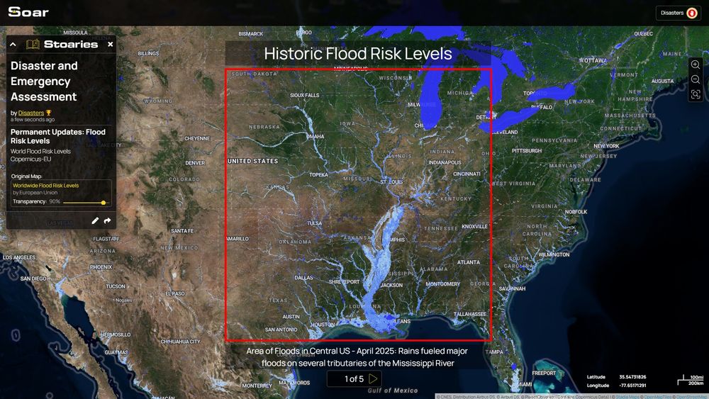
Updates on US Southeast-Midwest Floods:
Historic Flood Risk Levels
soar.earth/draw/2130
Probability of Flooding events
soar.earth/maps/16682
#Kentucky
Historic Flood Risk Levels
soar.earth/draw/2130
Probability of Flooding events
soar.earth/maps/16682
#Kentucky

April 15, 2025 at 3:24 PM
Updates on US Southeast-Midwest Floods:
Historic Flood Risk Levels
soar.earth/draw/2130
Probability of Flooding events
soar.earth/maps/16682
#Kentucky
Historic Flood Risk Levels
soar.earth/draw/2130
Probability of Flooding events
soar.earth/maps/16682
#Kentucky
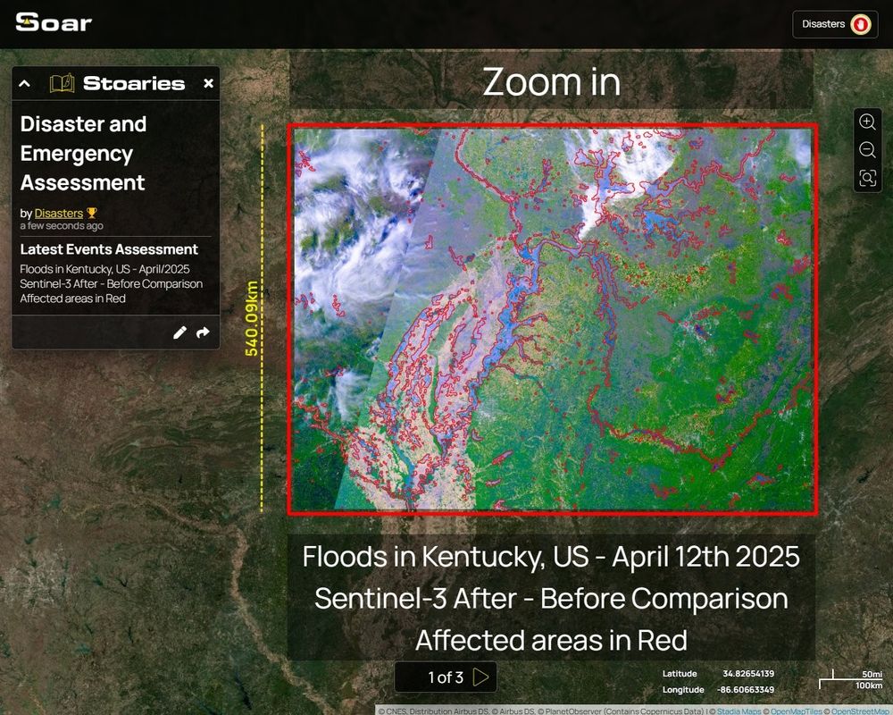
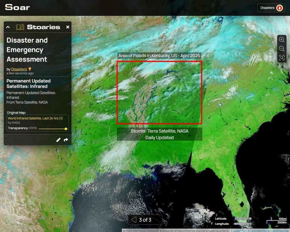
Soar.Earth @soarearth.bsky.social
Emergency & Disaster Assessment
Permanent Updates:
🔴Floods in Kentucky, US
~500km extension After x Before Comparison
Zoom in - Story Map at:
▶️ soar.earth/draw/2130
Emergency & Disaster Assessment
Permanent Updates:
🔴Floods in Kentucky, US
~500km extension After x Before Comparison
Zoom in - Story Map at:
▶️ soar.earth/draw/2130
April 15, 2025 at 12:05 AM
Soar.Earth @soarearth.bsky.social
Emergency & Disaster Assessment
Permanent Updates:
🔴Floods in Kentucky, US
~500km extension After x Before Comparison
Zoom in - Story Map at:
▶️ soar.earth/draw/2130
Emergency & Disaster Assessment
Permanent Updates:
🔴Floods in Kentucky, US
~500km extension After x Before Comparison
Zoom in - Story Map at:
▶️ soar.earth/draw/2130
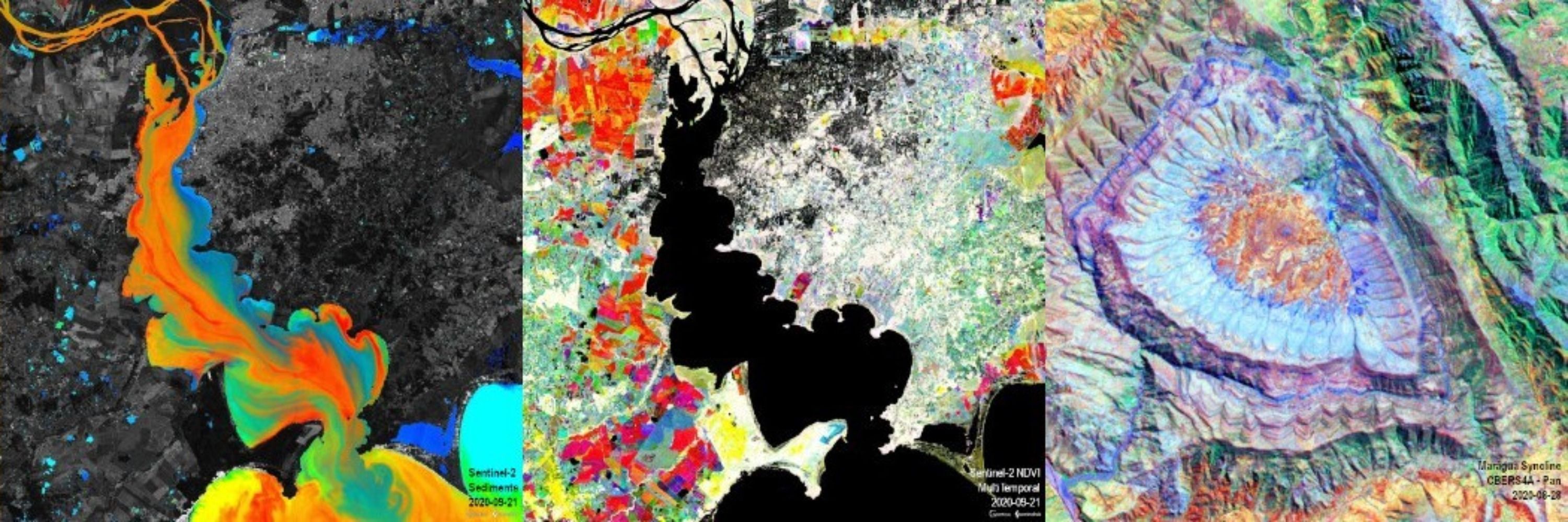
Satellite imagery enhancement:
+ Coastal sediments dynamic ,
+ Algae Concentration , . . .
🛰️Sentinel-2 Scripts
On 🚀Soar.Earth - The New Atlas🌐
@soarearth.bsky.social :
▶️ soar.earth/satellites/s...
Thanks to @CopernicusEU #OpenData
+ Coastal sediments dynamic ,
+ Algae Concentration , . . .
🛰️Sentinel-2 Scripts
On 🚀Soar.Earth - The New Atlas🌐
@soarearth.bsky.social :
▶️ soar.earth/satellites/s...
Thanks to @CopernicusEU #OpenData
April 11, 2025 at 2:41 PM
Satellite imagery enhancement:
+ Coastal sediments dynamic ,
+ Algae Concentration , . . .
🛰️Sentinel-2 Scripts
On 🚀Soar.Earth - The New Atlas🌐
@soarearth.bsky.social :
▶️ soar.earth/satellites/s...
Thanks to @CopernicusEU #OpenData
+ Coastal sediments dynamic ,
+ Algae Concentration , . . .
🛰️Sentinel-2 Scripts
On 🚀Soar.Earth - The New Atlas🌐
@soarearth.bsky.social :
▶️ soar.earth/satellites/s...
Thanks to @CopernicusEU #OpenData
Reposted by Sérgio OSMsmaprs
Alô Comunidade Latino-Americana #GIS
NEW! Free OpenData em Soar.Earth
@soarearth.bsky.social
🚨"Advanced Sentinel-2 Processing"
▶️ soar.earth/satellites/s...
+ 15 Preset Scripts
+ Scripts customizados: você cria e gera imagens.
+ Importe imagens para seus mapas em #Stoaries e compartilhe!
NEW! Free OpenData em Soar.Earth
@soarearth.bsky.social
🚨"Advanced Sentinel-2 Processing"
▶️ soar.earth/satellites/s...
+ 15 Preset Scripts
+ Scripts customizados: você cria e gera imagens.
+ Importe imagens para seus mapas em #Stoaries e compartilhe!
April 9, 2025 at 8:14 PM
Alô Comunidade Latino-Americana #GIS
NEW! Free OpenData em Soar.Earth
@soarearth.bsky.social
🚨"Advanced Sentinel-2 Processing"
▶️ soar.earth/satellites/s...
+ 15 Preset Scripts
+ Scripts customizados: você cria e gera imagens.
+ Importe imagens para seus mapas em #Stoaries e compartilhe!
NEW! Free OpenData em Soar.Earth
@soarearth.bsky.social
🚨"Advanced Sentinel-2 Processing"
▶️ soar.earth/satellites/s...
+ 15 Preset Scripts
+ Scripts customizados: você cria e gera imagens.
+ Importe imagens para seus mapas em #Stoaries e compartilhe!
April 9, 2025 at 8:14 PM
Alô Comunidade Latino-Americana #GIS
NEW! Free OpenData em Soar.Earth
@soarearth.bsky.social
🚨"Advanced Sentinel-2 Processing"
▶️ soar.earth/satellites/s...
+ 15 Preset Scripts
+ Scripts customizados: você cria e gera imagens.
+ Importe imagens para seus mapas em #Stoaries e compartilhe!
NEW! Free OpenData em Soar.Earth
@soarearth.bsky.social
🚨"Advanced Sentinel-2 Processing"
▶️ soar.earth/satellites/s...
+ 15 Preset Scripts
+ Scripts customizados: você cria e gera imagens.
+ Importe imagens para seus mapas em #Stoaries e compartilhe!
Floods in Queensland Outback
We processed on Soar @soarearth.bsky.social the recent @CSIRO NovaSAR-1 radar satellite image
2025 March, days:
31: NovaSAR-1 (Colored RGB image = HH, HV, HH/HV)
30: NOAA-21 Infrared, NASA
Map on Soar:
▶️ soar.earth/maps/133261
We processed on Soar @soarearth.bsky.social the recent @CSIRO NovaSAR-1 radar satellite image
2025 March, days:
31: NovaSAR-1 (Colored RGB image = HH, HV, HH/HV)
30: NOAA-21 Infrared, NASA
Map on Soar:
▶️ soar.earth/maps/133261
April 2, 2025 at 4:36 PM
Floods in Queensland Outback
We processed on Soar @soarearth.bsky.social the recent @CSIRO NovaSAR-1 radar satellite image
2025 March, days:
31: NovaSAR-1 (Colored RGB image = HH, HV, HH/HV)
30: NOAA-21 Infrared, NASA
Map on Soar:
▶️ soar.earth/maps/133261
We processed on Soar @soarearth.bsky.social the recent @CSIRO NovaSAR-1 radar satellite image
2025 March, days:
31: NovaSAR-1 (Colored RGB image = HH, HV, HH/HV)
30: NOAA-21 Infrared, NASA
Map on Soar:
▶️ soar.earth/maps/133261
Reposted by Sérgio OSMsmaprs

🗺️ Map of the day! Mount St. Helens - 30 June 1980.
Mount St. Helens and the surrounding area captured by a KH-9 spy satellite on 1980-06-30, just over a month after the famous 1980 eruption.
▶️ soar.short.gy/Mount_St_Hel...
Mount St. Helens and the surrounding area captured by a KH-9 spy satellite on 1980-06-30, just over a month after the famous 1980 eruption.
▶️ soar.short.gy/Mount_St_Hel...


March 31, 2025 at 1:19 PM
🗺️ Map of the day! Mount St. Helens - 30 June 1980.
Mount St. Helens and the surrounding area captured by a KH-9 spy satellite on 1980-06-30, just over a month after the famous 1980 eruption.
▶️ soar.short.gy/Mount_St_Hel...
Mount St. Helens and the surrounding area captured by a KH-9 spy satellite on 1980-06-30, just over a month after the famous 1980 eruption.
▶️ soar.short.gy/Mount_St_Hel...
Extensive Floods in Australia, Queensland Outback
Today Infrared Satellites
On Soar.Earth - The New Atlas:
@soarearth.bsky.social
NOAA-20:▶️ soar.earth/maps/15483
Comparison: 2025 March, 29 x 05 (24 days)
Today Infrared Satellites
On Soar.Earth - The New Atlas:
@soarearth.bsky.social
NOAA-20:▶️ soar.earth/maps/15483
Comparison: 2025 March, 29 x 05 (24 days)
March 29, 2025 at 3:11 PM
Extensive Floods in Australia, Queensland Outback
Today Infrared Satellites
On Soar.Earth - The New Atlas:
@soarearth.bsky.social
NOAA-20:▶️ soar.earth/maps/15483
Comparison: 2025 March, 29 x 05 (24 days)
Today Infrared Satellites
On Soar.Earth - The New Atlas:
@soarearth.bsky.social
NOAA-20:▶️ soar.earth/maps/15483
Comparison: 2025 March, 29 x 05 (24 days)
#PortoAlegre today early morning...
Good night 👋
Good night 👋

March 22, 2025 at 9:32 PM
#PortoAlegre today early morning...
Good night 👋
Good night 👋
🔴Israeli airstrikes on Syria last night: Palmyra and T4 Air Base
On Soar_Earth - The New Atlas🌐:
@soarearth.bsky.social
▶️ soar.earth/draw/1862
Highlighted based on After-Before comparison, Soil Index (R/B), Sentinel-2 2025-Mar, 22 x 02 @copernicusecmwf.bsky.social
On Soar_Earth - The New Atlas🌐:
@soarearth.bsky.social
▶️ soar.earth/draw/1862
Highlighted based on After-Before comparison, Soil Index (R/B), Sentinel-2 2025-Mar, 22 x 02 @copernicusecmwf.bsky.social


March 22, 2025 at 8:03 PM
🔴Israeli airstrikes on Syria last night: Palmyra and T4 Air Base
On Soar_Earth - The New Atlas🌐:
@soarearth.bsky.social
▶️ soar.earth/draw/1862
Highlighted based on After-Before comparison, Soil Index (R/B), Sentinel-2 2025-Mar, 22 x 02 @copernicusecmwf.bsky.social
On Soar_Earth - The New Atlas🌐:
@soarearth.bsky.social
▶️ soar.earth/draw/1862
Highlighted based on After-Before comparison, Soil Index (R/B), Sentinel-2 2025-Mar, 22 x 02 @copernicusecmwf.bsky.social
🤩Amazing archeological discovery!
Imagine living in a house where its basement holds a 11,000 years old neolithic stone wall engraved for ritual and collective activities!
Story Map on 🚀Soar_Earth - The New Atlas🌐
@soarearth.bsky.social
Soar-'Stoary':
🧐▶️ soar.earth/draw/1408 -page 10
Imagine living in a house where its basement holds a 11,000 years old neolithic stone wall engraved for ritual and collective activities!
Story Map on 🚀Soar_Earth - The New Atlas🌐
@soarearth.bsky.social
Soar-'Stoary':
🧐▶️ soar.earth/draw/1408 -page 10


March 22, 2025 at 1:02 PM
🤩Amazing archeological discovery!
Imagine living in a house where its basement holds a 11,000 years old neolithic stone wall engraved for ritual and collective activities!
Story Map on 🚀Soar_Earth - The New Atlas🌐
@soarearth.bsky.social
Soar-'Stoary':
🧐▶️ soar.earth/draw/1408 -page 10
Imagine living in a house where its basement holds a 11,000 years old neolithic stone wall engraved for ritual and collective activities!
Story Map on 🚀Soar_Earth - The New Atlas🌐
@soarearth.bsky.social
Soar-'Stoary':
🧐▶️ soar.earth/draw/1408 -page 10
Reposted by Sérgio OSMsmaprs
The Line, Neom, Saudi Arabia UPDATES:
tunnels; resorts; excavations...
Soar-Stoary
🚀Soar_Earth - The New Atlas🌐 @soarearth.bsky.social
Story Map with historic of working progress
2022-2023-2024
▶️ soar.earth/draw/2053
#engineering #environment
tunnels; resorts; excavations...
Soar-Stoary
🚀Soar_Earth - The New Atlas🌐 @soarearth.bsky.social
Story Map with historic of working progress
2022-2023-2024
▶️ soar.earth/draw/2053
#engineering #environment


March 20, 2025 at 1:55 AM
The Line, Neom, Saudi Arabia UPDATES:
tunnels; resorts; excavations...
Soar-Stoary
🚀Soar_Earth - The New Atlas🌐 @soarearth.bsky.social
Story Map with historic of working progress
2022-2023-2024
▶️ soar.earth/draw/2053
#engineering #environment
tunnels; resorts; excavations...
Soar-Stoary
🚀Soar_Earth - The New Atlas🌐 @soarearth.bsky.social
Story Map with historic of working progress
2022-2023-2024
▶️ soar.earth/draw/2053
#engineering #environment
🚨NEW‼️:
Advanced 🛰️#Sentinel Processing
-Satellite imagery RGB Scripting
On 🚀@Soar_Earth - The New Atlas🌐:
🔴Apply for #FREE early access!
100 slots available!
FORM AT:⬇️
x.com/x4rius/statu...
Advanced 🛰️#Sentinel Processing
-Satellite imagery RGB Scripting
On 🚀@Soar_Earth - The New Atlas🌐:
🔴Apply for #FREE early access!
100 slots available!
FORM AT:⬇️
x.com/x4rius/statu...


March 15, 2025 at 7:09 PM
🚨NEW‼️:
Advanced 🛰️#Sentinel Processing
-Satellite imagery RGB Scripting
On 🚀@Soar_Earth - The New Atlas🌐:
🔴Apply for #FREE early access!
100 slots available!
FORM AT:⬇️
x.com/x4rius/statu...
Advanced 🛰️#Sentinel Processing
-Satellite imagery RGB Scripting
On 🚀@Soar_Earth - The New Atlas🌐:
🔴Apply for #FREE early access!
100 slots available!
FORM AT:⬇️
x.com/x4rius/statu...