


Alex Normandeau
@sedialex.bsky.social
Marine geoscientist at the Geological Survey of Canada (Atlantic)
We have a new paper in Science Advances on seasonal movements of the sub-Arctic seafloor. Using sub-annual bathymetry, porewater data, and moored sensors, we observed the seabed expanding and contracting through freeze–thaw cycles, forming seasonal frost blisters.
doi.org/10.1126/scia...
doi.org/10.1126/scia...
October 29, 2025 at 6:12 PM
We have a new paper in Science Advances on seasonal movements of the sub-Arctic seafloor. Using sub-annual bathymetry, porewater data, and moored sensors, we observed the seabed expanding and contracting through freeze–thaw cycles, forming seasonal frost blisters.
doi.org/10.1126/scia...
doi.org/10.1126/scia...
Reposted by Alex Normandeau

📣The May issue of CJES is now LIVE.
📃Featuring: "Holocene earthquake-triggered submarine landslides and turbidites in western Baffin Bay" by @sedialex.bsky.social et al. cdnsciencepub.com/doi/full/10....
📸Fig 1. Study sites in western Baffin Bay. #marine #landslide #geosky #earthquake #geoscience
📃Featuring: "Holocene earthquake-triggered submarine landslides and turbidites in western Baffin Bay" by @sedialex.bsky.social et al. cdnsciencepub.com/doi/full/10....
📸Fig 1. Study sites in western Baffin Bay. #marine #landslide #geosky #earthquake #geoscience

May 7, 2025 at 4:17 PM
📣The May issue of CJES is now LIVE.
📃Featuring: "Holocene earthquake-triggered submarine landslides and turbidites in western Baffin Bay" by @sedialex.bsky.social et al. cdnsciencepub.com/doi/full/10....
📸Fig 1. Study sites in western Baffin Bay. #marine #landslide #geosky #earthquake #geoscience
📃Featuring: "Holocene earthquake-triggered submarine landslides and turbidites in western Baffin Bay" by @sedialex.bsky.social et al. cdnsciencepub.com/doi/full/10....
📸Fig 1. Study sites in western Baffin Bay. #marine #landslide #geosky #earthquake #geoscience
Our new study out in G-cubed, wrapping up 8 years of repeat seafloor mapping, flow monitoring, and sediment coring in a glacierized fjord. We made some interesting discoveries about how glaciers, turbidity currents, and submarine landslides interact in these dynamic environments
tinyurl.com/49xms8hr
tinyurl.com/49xms8hr

April 10, 2025 at 6:43 PM
Our new study out in G-cubed, wrapping up 8 years of repeat seafloor mapping, flow monitoring, and sediment coring in a glacierized fjord. We made some interesting discoveries about how glaciers, turbidity currents, and submarine landslides interact in these dynamic environments
tinyurl.com/49xms8hr
tinyurl.com/49xms8hr
Reposted by Alex Normandeau

Ooooh new paper from @sedialex.bsky.social that is going to go right to the top of my pile of papers to read! 🧪⚒️ "Processes and Products of Turbidity Currents and Submarine Landslides in a Glacierized Fjord (Southwind Fjord, Baffin Island)" agupubs.onlinelibrary.wiley.com/doi/full/10....

Processes and Products of Turbidity Currents and Submarine Landslides in a Glacierized Fjord (Southwind Fjord, Baffin Island)
Overview of 8 years of seabed mapping, flow monitoring and sediment coring in a dynamic glacierized fjord Turbidity currents occur every year and confine sand to the fjord basin floor with little...
agupubs.onlinelibrary.wiley.com
April 10, 2025 at 4:59 PM
Ooooh new paper from @sedialex.bsky.social that is going to go right to the top of my pile of papers to read! 🧪⚒️ "Processes and Products of Turbidity Currents and Submarine Landslides in a Glacierized Fjord (Southwind Fjord, Baffin Island)" agupubs.onlinelibrary.wiley.com/doi/full/10....
Elisabeth Steel (Queen's U.) and I invite you to submit abstracts on clastic marine sedimentology. Our session aims to connect marine sedimentologists working on modern, experimental, and ancient depositional systems, bridging the gap between these fields. Deadline for abstract submission: Feb. 16!
The list of conf. sessions is now available for Ottawa2025 annual meeting of GAC/MAC/IAH-CNC. Currently in a PDF file, but download and get an early feel for this multi-society meeting, Canada's premier geoscience meeting.
@harveythorleifson.bsky.social
event.fourwaves.com/ottawa2025/p...
@harveythorleifson.bsky.social
event.fourwaves.com/ottawa2025/p...

GAC-MAC-IAH-CNC 2025 OTTAWA
Fourwaves - GAC-MAC-IAH-CNC 2025 OTTAWA
event.fourwaves.com
December 3, 2024 at 2:58 PM
Elisabeth Steel (Queen's U.) and I invite you to submit abstracts on clastic marine sedimentology. Our session aims to connect marine sedimentologists working on modern, experimental, and ancient depositional systems, bridging the gap between these fields. Deadline for abstract submission: Feb. 16!
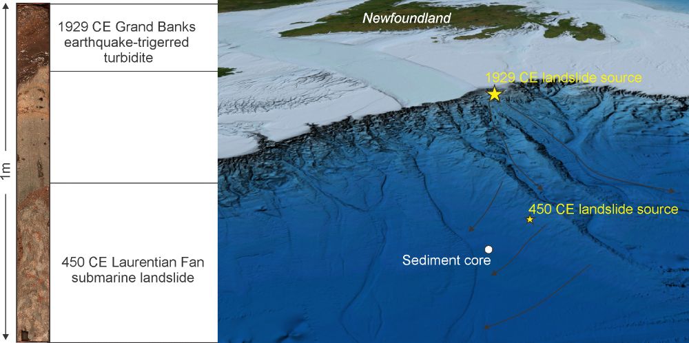
Just like the 1929 earthquake was recorded in marine sediments offshore Atlantic Canada, the 1933 earthquake triggered a turbidite in Baffin Bay. Sediment cores from the region suggest other large earthquakes occurred during the late Holocene. Stay tuned for our upcoming paper on the subject

November 21, 2024 at 1:10 AM
Just like the 1929 earthquake was recorded in marine sediments offshore Atlantic Canada, the 1933 earthquake triggered a turbidite in Baffin Bay. Sediment cores from the region suggest other large earthquakes occurred during the late Holocene. Stay tuned for our upcoming paper on the subject
The earthquake triggered a submarine landslide and turbidite recorded in marine sediments offshore Atlantic Canada. We know other very large landslides occurred during the last 4,000 years thanks to marine sediment cores collected in the deep waters of eastern Canada
November 19, 2024 at 12:50 AM
The earthquake triggered a submarine landslide and turbidite recorded in marine sediments offshore Atlantic Canada. We know other very large landslides occurred during the last 4,000 years thanks to marine sediment cores collected in the deep waters of eastern Canada
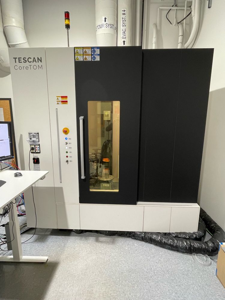
These same sediment cores being analyzed through a CT-Scan and a μCT-Scan to reconstruct the past history of the region

November 18, 2024 at 2:19 AM
These same sediment cores being analyzed through a CT-Scan and a μCT-Scan to reconstruct the past history of the region
How is marine geoscience conducted at the Geological Survey of Canada? Here are some of the tools we use to characterize the seafloor and monitor seabed processes, in collaboration with our partners from academia and other government departments.

October 2, 2024 at 4:29 PM
How is marine geoscience conducted at the Geological Survey of Canada? Here are some of the tools we use to characterize the seafloor and monitor seabed processes, in collaboration with our partners from academia and other government departments.
We deployed an autonomous underwater vehicle and 3 moorings in Shortland Canyon, eastern Canada, from the RRS Discovery. Sediment cores were also recovered from the canyon bottom. These data will allow us to understand the physical oceanography and seabed processes in eastern Canadian canyons.


September 24, 2024 at 7:05 PM
We deployed an autonomous underwater vehicle and 3 moorings in Shortland Canyon, eastern Canada, from the RRS Discovery. Sediment cores were also recovered from the canyon bottom. These data will allow us to understand the physical oceanography and seabed processes in eastern Canadian canyons.
A few years ago, I created animations to illustrate how geological sampling and surveys are conducted at sea. Here are two examples: 1) piston coring to collect long sediment cores 2) multibeam surveys to create maps of the seafloor. Animations are available here: sites.google.com/view/normand...


September 7, 2024 at 6:15 PM
A few years ago, I created animations to illustrate how geological sampling and surveys are conducted at sea. Here are two examples: 1) piston coring to collect long sediment cores 2) multibeam surveys to create maps of the seafloor. Animations are available here: sites.google.com/view/normand...