


SchoolShake
@schoolshake.bsky.social
School-based seismic network and earthquake outreach on Vancouver Island
A series of 3 earthquakes this morning in and around Southern Vancouver Island:
6:06 AM M1.0 20km deep beneath Victoria
8:45 AM M1.6 22km deep just south of Victoria
9:11 AM M0.8 23 km deep just south of Victoria near Washington State.
(SchoolShake Waveforms in the next post).
6:06 AM M1.0 20km deep beneath Victoria
8:45 AM M1.6 22km deep just south of Victoria
9:11 AM M0.8 23 km deep just south of Victoria near Washington State.
(SchoolShake Waveforms in the next post).


December 27, 2025 at 5:50 PM
A series of 3 earthquakes this morning in and around Southern Vancouver Island:
6:06 AM M1.0 20km deep beneath Victoria
8:45 AM M1.6 22km deep just south of Victoria
9:11 AM M0.8 23 km deep just south of Victoria near Washington State.
(SchoolShake Waveforms in the next post).
6:06 AM M1.0 20km deep beneath Victoria
8:45 AM M1.6 22km deep just south of Victoria
9:11 AM M0.8 23 km deep just south of Victoria near Washington State.
(SchoolShake Waveforms in the next post).
Small earthquake local to Victoria, just over a half hour ago, at 12:10 PST. At 25km depth just off from Albert Head.


November 9, 2025 at 8:44 PM
Small earthquake local to Victoria, just over a half hour ago, at 12:10 PST. At 25km depth just off from Albert Head.
Tuesday's 530am #earthquake was a well-timed follow-up to #ShakeOutBC. The early timing and quiet schools resulted in the event being nicely recorded on all #SchoolShake instruments. If you felt it, you can still report it here www.earthquakescanada.nrcan.gc.ca/dyfi-lavr/fo...


October 24, 2025 at 11:01 PM
Tuesday's 530am #earthquake was a well-timed follow-up to #ShakeOutBC. The early timing and quiet schools resulted in the event being nicely recorded on all #SchoolShake instruments. If you felt it, you can still report it here www.earthquakescanada.nrcan.gc.ca/dyfi-lavr/fo...
This mornings M3.0 felt earthquake near Duncan was well recorded on the #SchoolShake network. No damages expected, but a great reminder to be prepared.
Felt reports and details: www.earthquakescanada.nrcan.gc.ca/recent/2025/...
Felt reports and details: www.earthquakescanada.nrcan.gc.ca/recent/2025/...


September 18, 2025 at 9:36 PM
This mornings M3.0 felt earthquake near Duncan was well recorded on the #SchoolShake network. No damages expected, but a great reminder to be prepared.
Felt reports and details: www.earthquakescanada.nrcan.gc.ca/recent/2025/...
Felt reports and details: www.earthquakescanada.nrcan.gc.ca/recent/2025/...
Felt earthquake in the Juan de Fuca straight just south of Victoria! This was felt across the CRD and in Washington State. No damage expected, but another reminder we live in earthquake country.


August 19, 2025 at 3:44 AM
Felt earthquake in the Juan de Fuca straight just south of Victoria! This was felt across the CRD and in Washington State. No damage expected, but another reminder we live in earthquake country.
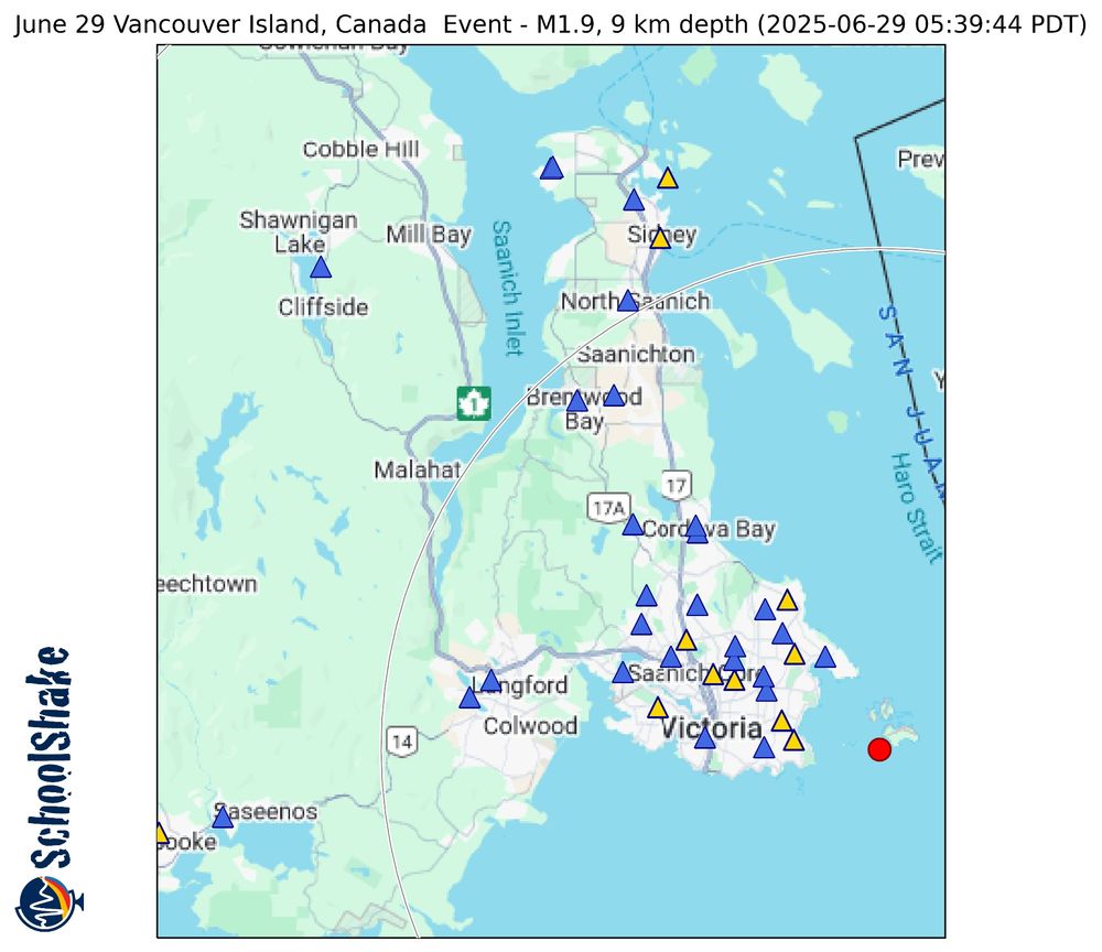
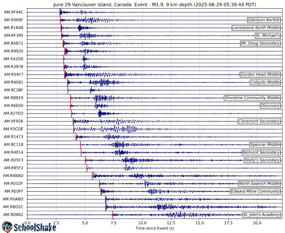
Small M1.9 earthquake this morning just offshore #VictoriaBC, at 5:39 am PDT, at 9 km depth. While not large enough to cause damage and not likely to be felt, another reminder of the hazard across the region. Well recoded by the @schoolshake.bsky.social @raspishake.bsky.social network.
June 29, 2025 at 7:06 PM
Small M1.9 earthquake this morning just offshore #VictoriaBC, at 5:39 am PDT, at 9 km depth. While not large enough to cause damage and not likely to be felt, another reminder of the hazard across the region. Well recoded by the @schoolshake.bsky.social @raspishake.bsky.social network.
Victoria, there was a small earthquake 17km below South Oak Bay in the wee hours last night (around 03:41 AM). This was really well detected by our @raspishake.bsky.social network of @schoolshake.bsky.social seismometers! This was a very small event at depth, so would definitely not cause any damage


May 7, 2025 at 11:08 PM
Victoria, there was a small earthquake 17km below South Oak Bay in the wee hours last night (around 03:41 AM). This was really well detected by our @raspishake.bsky.social network of @schoolshake.bsky.social seismometers! This was a very small event at depth, so would definitely not cause any damage
A shallow Magnitude ~2.5 occurred 5:41pm local time near the Canada-US border, between Langley and Abbotsford. Detected with @raspishake.bsky.social instruments across the MVRD and CRD.


April 3, 2025 at 1:01 AM
A shallow Magnitude ~2.5 occurred 5:41pm local time near the Canada-US border, between Langley and Abbotsford. Detected with @raspishake.bsky.social instruments across the MVRD and CRD.
While almost certainly not felt, another example of a local, deep earthquake happen yesterday just off the Saanich Peninsula. An M2.3 event at 49 km depth, which was well recorded by most of our @raspishake.bsky.social stations in the area. @seos-uvic.bsky.social @hakai.org


March 27, 2025 at 4:28 PM
While almost certainly not felt, another example of a local, deep earthquake happen yesterday just off the Saanich Peninsula. An M2.3 event at 49 km depth, which was well recorded by most of our @raspishake.bsky.social stations in the area. @seos-uvic.bsky.social @hakai.org
Small Earthquake just off from Colwood this afternoon at 4:24 PM local time. A small M0.8 event at 9 km depth, but still detectable with the local seismic networks and a few of the SchoolShake stations!


March 13, 2025 at 12:04 AM
Small Earthquake just off from Colwood this afternoon at 4:24 PM local time. A small M0.8 event at 9 km depth, but still detectable with the local seismic networks and a few of the SchoolShake stations!
Reposted by SchoolShake

Another day, another small earthquake in the northern Cascadia forearc. Here it is on one of our @schoolshake.bsky.social seismometers in Victoria BC 🇨🇦

March 6, 2025 at 2:32 AM
Another day, another small earthquake in the northern Cascadia forearc. Here it is on one of our @schoolshake.bsky.social seismometers in Victoria BC 🇨🇦
Reposted by SchoolShake
Did you feel shaking at 4:18 PT this afternoon on southern #VancouverIsland or the Olympic Peninsula, #WA? That was a M3.9 earthquake located 60 km south of Victoria and 30 km south of Port Angeles.
More: www.earthquakescanada.nrcan.gc.ca/recent/2025/...
USGS: earthquake.usgs.gov/earthquakes/... ⚒️🧪
More: www.earthquakescanada.nrcan.gc.ca/recent/2025/...
USGS: earthquake.usgs.gov/earthquakes/... ⚒️🧪


March 6, 2025 at 1:36 AM
Did you feel shaking at 4:18 PT this afternoon on southern #VancouverIsland or the Olympic Peninsula, #WA? That was a M3.9 earthquake located 60 km south of Victoria and 30 km south of Port Angeles.
More: www.earthquakescanada.nrcan.gc.ca/recent/2025/...
USGS: earthquake.usgs.gov/earthquakes/... ⚒️🧪
More: www.earthquakescanada.nrcan.gc.ca/recent/2025/...
USGS: earthquake.usgs.gov/earthquakes/... ⚒️🧪
Another small but felt earthquake occured March 6th at 16:18 PST, deep within the Olympic Mountains of Washington State. While a M3.8-3.9, at 42km depth it was not as widely felt as Monday's. Picked up nicely on the SchoolShake @raspishake.bsky.social Network.


March 6, 2025 at 3:14 AM
Another small but felt earthquake occured March 6th at 16:18 PST, deep within the Olympic Mountains of Washington State. While a M3.8-3.9, at 42km depth it was not as widely felt as Monday's. Picked up nicely on the SchoolShake @raspishake.bsky.social Network.
Mw 4.1 Earthquake beneath Orcas Island, this morning at 05:03:37 PST. The earthquake occurred at a depth of 17 km, and was felt across the region. Attached is the location of the event, as well as the signal from it recorded on Raspberry Shake Seismometer throughout the region!


March 3, 2025 at 5:44 PM
Mw 4.1 Earthquake beneath Orcas Island, this morning at 05:03:37 PST. The earthquake occurred at a depth of 17 km, and was felt across the region. Attached is the location of the event, as well as the signal from it recorded on Raspberry Shake Seismometer throughout the region!
Reposted by SchoolShake
That was quite the shake here in #Victoria 🇨🇦 at 05:02 PT.
M4.6 near Orcas Island, 45 km ENE from Victoria and 70 km from Vancouver.
Felt all across southwest BC and northwest WA.
Details and to report shaking:
www.earthquakescanada.nrcan.gc.ca/recent/2025/...
M4.6 near Orcas Island, 45 km ENE from Victoria and 70 km from Vancouver.
Felt all across southwest BC and northwest WA.
Details and to report shaking:
www.earthquakescanada.nrcan.gc.ca/recent/2025/...


March 3, 2025 at 1:24 PM
That was quite the shake here in #Victoria 🇨🇦 at 05:02 PT.
M4.6 near Orcas Island, 45 km ENE from Victoria and 70 km from Vancouver.
Felt all across southwest BC and northwest WA.
Details and to report shaking:
www.earthquakescanada.nrcan.gc.ca/recent/2025/...
M4.6 near Orcas Island, 45 km ENE from Victoria and 70 km from Vancouver.
Felt all across southwest BC and northwest WA.
Details and to report shaking:
www.earthquakescanada.nrcan.gc.ca/recent/2025/...
Reposted by SchoolShake
Clear P and S wave arrivals recorded by @schoolshake.bsky.social at North Saanich Middle School here on southern Vancouver Island. No relation to the M 5 Sechelt earthquake ten days ago (120 km N… too far for a direct aftershock for an EQ this size)

March 3, 2025 at 5:25 PM
Clear P and S wave arrivals recorded by @schoolshake.bsky.social at North Saanich Middle School here on southern Vancouver Island. No relation to the M 5 Sechelt earthquake ten days ago (120 km N… too far for a direct aftershock for an EQ this size)
M5 earthquake north of Sechelt, BC, occurred at 13:26:33 local time (PST). Widely felt across the Sunshine Coast, Lower Mainland and Vancouver Island. Picked up across the SchoolShake Network.


February 21, 2025 at 10:13 PM
M5 earthquake north of Sechelt, BC, occurred at 13:26:33 local time (PST). Widely felt across the Sunshine Coast, Lower Mainland and Vancouver Island. Picked up across the SchoolShake Network.
Here are the waveforms from the 23:23 UTC Cayman Islands Mw7.6 that occurred earlier today. You can see the waves arrive across the SchoolShake Network Raspberry Shakes in South West BC a bit more than 8 minutes after the earthquake.


February 9, 2025 at 2:49 AM
Here are the waveforms from the 23:23 UTC Cayman Islands Mw7.6 that occurred earlier today. You can see the waves arrive across the SchoolShake Network Raspberry Shakes in South West BC a bit more than 8 minutes after the earthquake.