Robin Hogan
banner
robinjhogan.bsky.social
Robin Hogan
@robinjhogan.bsky.social

Principal Scientist at #ECMWF and Professor of Atmospheric Physics at the University of Reading - Radiative Transfer - #EarthCARE enthusiast https://www.ecmwf.int/en/about/who-we-are/staff-profiles/robin-hogan

Environmental science 52%
Geography 19%

Here is the wider context: satellite observations on the left and the two model versions on the right, visible imagery on top and thermal infrared on the bottom. The eye is stubbornly too wide in the model: what should we change in the model to improve this?

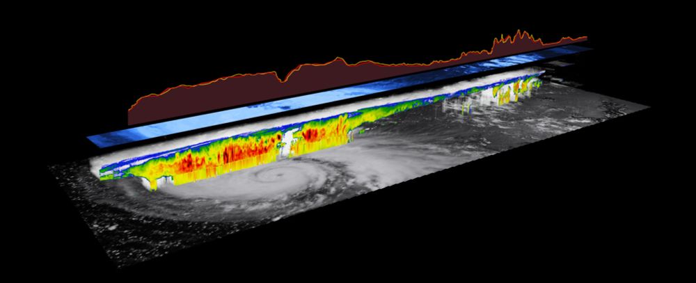
Never before have we been able to measure vertical velocities from space: on the top is EarthCARE showing falling rain and snow (blue) but in the eye-wall the cloud particles are lofted up (red). The next two panels show the 9- and 4.4-km models with the 4.4-km starting to capture the updrafts!

Reposted by Mario Mech

In this ECMWF blog post, Mark Fielding compares model simulations at 9- and 4.4-km resolution with #EarthCARE radar observations of Hurricane Humberto, which was sampled right through its eye on 28 September 2025: www.ecmwf.int/en/about/med...

Check out in particular the video explaining how the synergy retrievals are evaluated by "radiative closure": www.youtube.com/watch?v=4d_k...
EarthCARE’s instruments work in synergy to improve climate models
YouTube video by ESA Extras
www.youtube.com

Reposted by Du Toit

First day of the EarthCARE Science & Validation workshop on the beautiful University of Tokyo campus! Takuji Kubota described today's release of all the Japanese products, including those using the synergy of 3 & 4 instruments.

Reposted by Du Toit

Nice article about the various online and offline visualization and analysis tools that are available for exploring EarthCARE data - thanks to Eleni Marinou (@elmarinou.bsky.social) who coordinates the development of these tools! earth.esa.int/eogateway/ne...
Exploring EarthCARE Data and Analysis Tools - Earth Online
To fully exploit the wealth of EarthCARE data, ESA and its partners have developed a comprehensive suite of data access, visualisation, analysis, and simulation tools. These tools not only support sci...
earth.esa.int

Exciting week next week with the release of the full tranche of #EarthCARE products, including those using 3 and 4 of the instruments in synergy! JAXA held a media briefing earlier today and I explained why this is important (48mins in). www.youtube.com/live/9375tqa...

Reposted by Du Toit

Aircraft contrails are contributing to global warming, but the balance between their solar and infrared effects is uncertain. EarthCARE's combination of instruments, particularly its high resolution 3-view broadband radiometer, is perfectly placed to measure them! earth.esa.int/eogateway/su...
Contrail climate effects under EarthCARE’s spotlight - Earth Online
Reducing the climate impact of air travel is a key goal, as the sector continues to expand globally. Aviation contributes 2.5% of global carbon dioxide emissions, but the industry is responsible for 5...
earth.esa.int

This ECMWF training course is a great opportunity to learn about how physical processes are represented in weather and climate models, free for anyone in an ECMWF member state. It runs 2-6 March 2026 and the deadline for applications is 30 November. events.ecmwf.int/event/496/
Training course: Parametrization of subgrid physical processes
This five-day course is a combination of lectures, hands-on practicals and group problem classes. During the course each parametrized process is introduced and discusses theory, modelling and verifica...
events.ecmwf.int

Nice paper, thanks! ECMWF web article coming soon comparing our observations of Humberto with simulations by the IFS at high resolution.

There are some tools listed at the page below. This image was produced by Shannon Mason using his free ectools package but I would like these to be produced routinely for all EarthCARE frames. www.earthcarescience.net/tools
EarthCARE Science - Tools
Online visualization
www.earthcarescience.net

Would you believe it: just 10 days after #EarthCARE went through the eye of Hurricane Humberto, it did the same with Hurricane Priscilla in the East Pacific on 7 October! A very different beast this one: a huge eye around 100 km across, and very lopsided, with much more rain on the southern side.

Second, the signal from the "Rayleigh" channel of EarthCARE's lidar is strongly related with ocean chlorophyll estimates from routine ocean colour measurements, with the advantage that EarthCARE's lidar can continue to make measurements in polar night!

First, the depolarisation of the land surface measured by EarthCARE's lidar seems to be very well correlated to the widely used "NDVI" vegetation index - but why? We don't yet know but potentially this could be telling us something new about vegetation!

New instruments always throw up surprises - Gerd-Jan van Zadelhoff of KNMI had a look at the #EarthCARE lidar's surface returns and found some intriguing and unexpected things as explained in ESA's latest EarthCARE web story... earth.esa.int/eogateway/su...

And here's EarthCARE's radar reflectivity with GOES-E for context (thanks to Mark Fielding)!

The level of detail revealed by EarthCARE is amazing: as well as the usual change in vertical Doppler velocity as snow melts to rain, we can see the rising air in the eye wall! The imager also captures the 3D nature of the convective cells in the rain bands further out. More analysis to come...
So this is pretty amazing - yesterday EarthCARE sampled Hurricane Humberto straight across the eye! The eye of a tropical cyclone is small so a direct hit is rare: this is the first time EarthCARE has hit one after over a year in orbit! (Showing here also VIIRS on NOAA-20 for context.)

...and the volcanic plume from Klyuchevskaya Sopka in Russia, which erupted July-August 2025. More coming soon! Thanks as always to @masonshannon.bsky.social for many of the images and to NASA Worldview for the wider context. worldview.earthdata.nasa.gov?v=154.961959...

EarthCARE is a inexhaustible source of beautiful imagery of some of the most spectacular phenomena nature has to offer, so I've started a Gallery page on the EarthCARE Science web site, showing for example convective motions in the trainbands of Typhoon Ragasa... www.earthcarescience.net/gallery

Reposted by Johannes Quaas

It's official: WIVERN will be ESA's 11th Earth Explorer satellite, measuring winds deep inside hurricanes, fronts and other weather systems!
www.esa.int/Applications...
ESA selects WIVERN as 11th Earth Explorer mission
After meticulous preparation and rigorous evaluation, ESA’s Member States have selected WIVERN to become the 11th Earth Explorer mission to be implemented through the agency’s prestigious FutureEO pro...
www.esa.int

This is the first time this process has been observed from space, thanks to EarthCARE's Doppler radar and high-spectral-resolution lidar! But how common is it globally and do these optically thick clouds have an impact on precipitation or even climate? Only EarthCARE can answer these questions!

When we look at the cloud properties estimated by combining the radar, lidar and imager (using the "ACM-CAP" algorithm developed by @masonshannon.bsky.social and me) we see this layer contains high concentrations of very small ice crystals. The imager shows that they block upward thermal radiation.

These are atmospheric gravity waves with a wavelength of 18 km, probably triggered by airflow over mountains; wavy structures are also seen in the zoomed-in radar and lidar backscatter. The updrafts bring air to liquid saturation and droplets form, but colder than -40°C they immediately freeze.

Another great #EarthCARE Image of the Month, this time led by Shannon Mason (@masonshannon.bsky.social): the Doppler radar sees wave structures in an Antarctic cloud while the lidar and imager see an optically thick ice cloud layer at around -45°C. What's going on? earth.esa.int/eogateway/su...