


Nova Scotia Weather Centre
@nswc.bsky.social
An independent news page dedicated to providing the latest & most up-to-date information regarding weather events in Nova Scotia and elsewhere in Atlantic Canada since 2019.
A tornado watch has been issued for #Fredericton and southern York County. Conditions are favourable for the development of severe thunderstorms that could produce a tornado. A strong cell to the northeast of Lincoln, Maine is expected in the area within an hour. #NBStorm


July 7, 2025 at 8:24 PM
A tornado watch has been issued for #Fredericton and southern York County. Conditions are favourable for the development of severe thunderstorms that could produce a tornado. A strong cell to the northeast of Lincoln, Maine is expected in the area within an hour. #NBStorm
Provincial highs today as of 3:30PM:
Jimtown: 31.2°C
Cape Dauphin: 31.2°C
Monastery: 31.1°C
Tarbotvale: 30.7°C
Ingonish: 30.6°C
Roberta: 30.6°C
Antigonish: 30.4°C
Lakevale: 30.4°C
Glace Bay: 30.4°C
Ingonish Harbour: 30.4°C
Kings Point: 30.3°C
Glen Tosh: 30.2°C
Sydney Mines: 30.0°C
#NSStorm #NSwx
Jimtown: 31.2°C
Cape Dauphin: 31.2°C
Monastery: 31.1°C
Tarbotvale: 30.7°C
Ingonish: 30.6°C
Roberta: 30.6°C
Antigonish: 30.4°C
Lakevale: 30.4°C
Glace Bay: 30.4°C
Ingonish Harbour: 30.4°C
Kings Point: 30.3°C
Glen Tosh: 30.2°C
Sydney Mines: 30.0°C
#NSStorm #NSwx

July 2, 2025 at 6:38 PM

Some moderate rainfall has pushed its way into western Nova Scotia and is now reaching #Halifax a little earlier than anticipated. Rain will continue to push east into the rest of the mainland throughout the day and there is a risk of embedded thundershowers later on. #NSStorm

June 28, 2025 at 2:09 PM

Reposted by Nova Scotia Weather Centre

An extremely rare 30° day in Yarmouth, Nova Scotia today!
This is just the 6th time the town has hit 30° since 1871 (154 years).
Today's 30.4° is the first time to reach the mark in the month of June.
The other 5 occurrences were in July (1911, 1968, 1977, 1993 & 2013)
#nswx #halisky
This is just the 6th time the town has hit 30° since 1871 (154 years).
Today's 30.4° is the first time to reach the mark in the month of June.
The other 5 occurrences were in July (1911, 1968, 1977, 1993 & 2013)
#nswx #halisky

June 25, 2025 at 9:30 PM


Widespread values of 30°C and higher are being reported across Nova Scotia early this afternoon. Temperatures will continue to rise and peak around 3-4pm likely nearing or reaching 35°C for some areas, which will feel more like 40-45 with the humidex. Stay hydrated! #NSStorm

June 24, 2025 at 4:21 PM
Widespread values of 30°C and higher are being reported across Nova Scotia early this afternoon. Temperatures will continue to rise and peak around 3-4pm likely nearing or reaching 35°C for some areas, which will feel more like 40-45 with the humidex. Stay hydrated! #NSStorm
A line of thundershowers is making its way across Richmond county this morning. St. Peter's and surrounding areas currently being impacted. #NSStorm

June 24, 2025 at 1:16 PM
A line of thundershowers is making its way across Richmond county this morning. St. Peter's and surrounding areas currently being impacted. #NSStorm


Reposted by Nova Scotia Weather Centre

Gust of 153km/h! I looked at the Confederation Bridge camera: at 3:04pm, it was nasty on the bridge! Later you see motorcycles, high sided vehicles and travel trailers crossing. Indeed a severe thunderstorm! www.youtube.com/watch?embeds...
June 12, 2025 at 8:01 PM
Gust of 153km/h! I looked at the Confederation Bridge camera: at 3:04pm, it was nasty on the bridge! Later you see motorcycles, high sided vehicles and travel trailers crossing. Indeed a severe thunderstorm! www.youtube.com/watch?embeds...

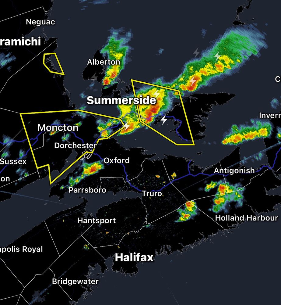
A line of strong thunderstorms has formed stretching from #Moncton, NB to #Summerside, PEI. Severe thunderstorm warnings are in effect across the area for frequent lightning, torrential downpours and potentially nickel sized hail. #NBStorm #PEStorm

June 12, 2025 at 5:38 PM
A line of strong thunderstorms has formed stretching from #Moncton, NB to #Summerside, PEI. Severe thunderstorm warnings are in effect across the area for frequent lightning, torrential downpours and potentially nickel sized hail. #NBStorm #PEStorm
A severe thunderstorm watch has been issued for Colchester County south of Truro and Pictou County. Thunderstorms have begun forming across areas of northern and central Nova Scotia at this hour. #NSStorm


June 12, 2025 at 5:33 PM
A severe thunderstorm watch has been issued for Colchester County south of Truro and Pictou County. Thunderstorms have begun forming across areas of northern and central Nova Scotia at this hour. #NSStorm
The severe thunderstorm warning has been extended up the coast of eastern New Brunswick stretching from Cape Tormentine to Escumniac. #NBStorm

June 12, 2025 at 5:20 PM
The severe thunderstorm warning has been extended up the coast of eastern New Brunswick stretching from Cape Tormentine to Escumniac. #NBStorm


Thunderstorms have begun to form across portions of western central New Brunswick this hour. They are expected to continue developing and head east-southeast into southeastern New Brunswick within the next couple hours where a severe thunderstorm watch is in effect. #NBStorm

June 12, 2025 at 3:32 PM
Thunderstorms have begun to form across portions of western central New Brunswick this hour. They are expected to continue developing and head east-southeast into southeastern New Brunswick within the next couple hours where a severe thunderstorm watch is in effect. #NBStorm