


NOAA
@noaa.gov
NOAA provides science, service and stewardship to protect life, property & Earth's natural resources. An agency of the Department of Commerce. Join us on Instagram & Facebook. Official NOAA account.
Pinned
Rain, sleet, snow? 🌦️🌧️⛈️🌨️🌞
Be in the know.
--> For 24/7 forecasts, watches & warnings, check out NOAA's National Weather Service here at: @nws.noaa.gov
And:
-- On Facebook at facebook.com/nws
-- On Instragram at instagram.com/nws
-- And at www.weather.gov to find our national weather map
Be in the know.
--> For 24/7 forecasts, watches & warnings, check out NOAA's National Weather Service here at: @nws.noaa.gov
And:
-- On Facebook at facebook.com/nws
-- On Instragram at instagram.com/nws
-- And at www.weather.gov to find our national weather map
Maybe the ice really IS all it’s cracked up to be on #LakeErie! 🧊
NOAA's #GOESEast (#GOES19) satellite captured a massive fracture forming in the lake ice on 2/8/26. It was approximately 80 miles long...
WATCH: satlib.cira.colostate.edu/weather_medi...
via NOAA NESDIS/CIRA
NOAA's #GOESEast (#GOES19) satellite captured a massive fracture forming in the lake ice on 2/8/26. It was approximately 80 miles long...
WATCH: satlib.cira.colostate.edu/weather_medi...
via NOAA NESDIS/CIRA

Massive Crack in Ice Forms on Lake Erie | CIRA Satellite Library
satlib.cira.colostate.edu
February 9, 2026 at 7:56 PM
Maybe the ice really IS all it’s cracked up to be on #LakeErie! 🧊
NOAA's #GOESEast (#GOES19) satellite captured a massive fracture forming in the lake ice on 2/8/26. It was approximately 80 miles long...
WATCH: satlib.cira.colostate.edu/weather_medi...
via NOAA NESDIS/CIRA
NOAA's #GOESEast (#GOES19) satellite captured a massive fracture forming in the lake ice on 2/8/26. It was approximately 80 miles long...
WATCH: satlib.cira.colostate.edu/weather_medi...
via NOAA NESDIS/CIRA
And... we'd like to welcome NOAA Fisheries (fisheries.noaa.gov) to our Bluesky community!

It’s #WhaleWeek! We’re celebrating these majestic marine mammals, which are among the largest and oldest animals on Earth. Found in every ocean, they range in size from the small dwarf sperm whale to the massive blue whale—the largest animal on the planet. 🤯 🌎
www.fisheries.noaa.gov/feature-stor...
www.fisheries.noaa.gov/feature-stor...

February 9, 2026 at 4:46 PM
And... we'd like to welcome NOAA Fisheries (fisheries.noaa.gov) to our Bluesky community!
Our Monthly Temperature & Precipitation Report is out again today, this time for January 2026:
"Warmth persisted across the West in January while wintry weather swept the Plains, South and East regions." ▶️ bit.ly/USClimate202... via NOAA's NCEI
"Warmth persisted across the West in January while wintry weather swept the Plains, South and East regions." ▶️ bit.ly/USClimate202... via NOAA's NCEI

Assessing the U.S. Temperature and Precipitation Analysis in January 2026
The average temperature for the contiguous U.S. in January was 33.2°F, 3.1°F above the 20th-century average, ranking in the warmest third of the 132-year record.
bit.ly
February 9, 2026 at 4:38 PM
Our Monthly Temperature & Precipitation Report is out again today, this time for January 2026:
"Warmth persisted across the West in January while wintry weather swept the Plains, South and East regions." ▶️ bit.ly/USClimate202... via NOAA's NCEI
"Warmth persisted across the West in January while wintry weather swept the Plains, South and East regions." ▶️ bit.ly/USClimate202... via NOAA's NCEI
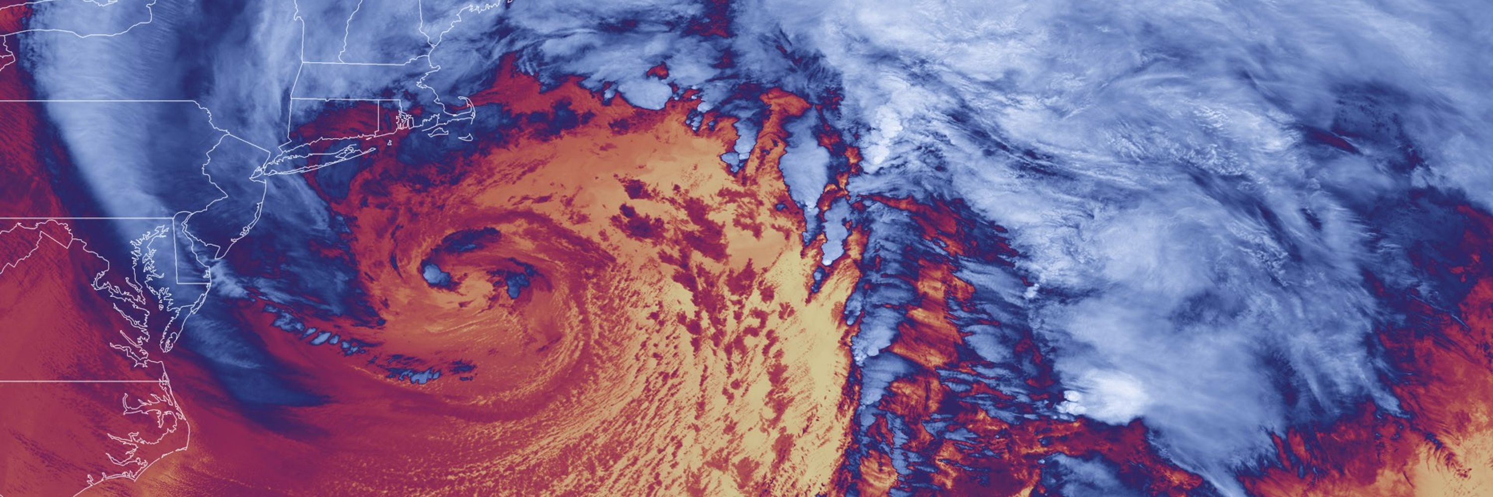
Reposted by NOAA

Visual of the cold air to come...
February 6, 2026 at 4:18 PM
Visual of the cold air to come...
Reposted by NOAA
& strong winds will bring dangerously cold wind chills as low as -30 to portions of the Interior Northeast/New England & as low as the negative single digits & teens closer to the coast Saturday AM to Sunday AM.
These wind chills will pose a life-threatening risk of hypothermia & frostbite.
These wind chills will pose a life-threatening risk of hypothermia & frostbite.
February 6, 2026 at 4:13 PM
& strong winds will bring dangerously cold wind chills as low as -30 to portions of the Interior Northeast/New England & as low as the negative single digits & teens closer to the coast Saturday AM to Sunday AM.
These wind chills will pose a life-threatening risk of hypothermia & frostbite.
These wind chills will pose a life-threatening risk of hypothermia & frostbite.
Reposted by NOAA
An arctic cold front will quickly track across the Great Lakes, Northeast & mid-Atlantic. Snow showers and squalls will accompany this system with increasing winds & falling temperatures.
Forecast highs Saturday will drop into the single digits, teens, and 20s. The combination of frigid temps...
Forecast highs Saturday will drop into the single digits, teens, and 20s. The combination of frigid temps...
February 6, 2026 at 4:13 PM
An arctic cold front will quickly track across the Great Lakes, Northeast & mid-Atlantic. Snow showers and squalls will accompany this system with increasing winds & falling temperatures.
Forecast highs Saturday will drop into the single digits, teens, and 20s. The combination of frigid temps...
Forecast highs Saturday will drop into the single digits, teens, and 20s. The combination of frigid temps...
Reposted by NOAA
Hurricane season may still be a few months away, but now is a good time to start thinking about your plan. Know your risk, create an evacuation kit, and stock up a disaster supply kit while the weather is quiet.
weather.gov/safety
weather.gov/safety

February 5, 2026 at 3:09 PM
Hurricane season may still be a few months away, but now is a good time to start thinking about your plan. Know your risk, create an evacuation kit, and stock up a disaster supply kit while the weather is quiet.
weather.gov/safety
weather.gov/safety
Reposted by NOAA
Not that uncommon, but unusual to see Great Falls, MT (64) be warmer than Tallahassee, FL (63) in the dead of winter. Temperatures will begin to moderate by early next week, but not before several days of continued warmth out west and frigid cold in the east.
February 4, 2026 at 3:58 PM
Not that uncommon, but unusual to see Great Falls, MT (64) be warmer than Tallahassee, FL (63) in the dead of winter. Temperatures will begin to moderate by early next week, but not before several days of continued warmth out west and frigid cold in the east.
Reposted by NOAA
A low pressure wave will bring light wintry precipitation from the upper Ohio Valley to the Mid-Atlantic, and rain/thunderstorms from the South to the Southeast through Wednesday. Visit weather.gov for details.


February 3, 2026 at 3:09 PM
A low pressure wave will bring light wintry precipitation from the upper Ohio Valley to the Mid-Atlantic, and rain/thunderstorms from the South to the Southeast through Wednesday. Visit weather.gov for details.
#GroundhogDay HAS ARRIVED:
#PunxsutawneyPhil stepped into the frigid morning air and saw his shadow, which legend has it that we'll see 6 more weeks of #winter.
Will he be right this year or can you put away all your winter gear?
www.ncei.noaa.gov/news/what-wi...
[Photo: This is NOT Phil.]
#PunxsutawneyPhil stepped into the frigid morning air and saw his shadow, which legend has it that we'll see 6 more weeks of #winter.
Will he be right this year or can you put away all your winter gear?
www.ncei.noaa.gov/news/what-wi...
[Photo: This is NOT Phil.]

What Will Punxsutawney Phil’s Six-Week Weather Prediction Be?
Every February 2, we anxiously await groundhog Punxsutawney Phil’s prediction of spring’s arrival, but how accurate is he?
www.ncei.noaa.gov
February 2, 2026 at 2:21 PM
#GroundhogDay HAS ARRIVED:
#PunxsutawneyPhil stepped into the frigid morning air and saw his shadow, which legend has it that we'll see 6 more weeks of #winter.
Will he be right this year or can you put away all your winter gear?
www.ncei.noaa.gov/news/what-wi...
[Photo: This is NOT Phil.]
#PunxsutawneyPhil stepped into the frigid morning air and saw his shadow, which legend has it that we'll see 6 more weeks of #winter.
Will he be right this year or can you put away all your winter gear?
www.ncei.noaa.gov/news/what-wi...
[Photo: This is NOT Phil.]
Reposted by NOAA
With another blast of cold air expected Friday through Sunday (Jan. 30 - Feb. 1) across the southeast U.S., be sure to check in on those in your community who might need extra help weathering these temperatures. weather.gov/safety

January 29, 2026 at 8:11 PM
With another blast of cold air expected Friday through Sunday (Jan. 30 - Feb. 1) across the southeast U.S., be sure to check in on those in your community who might need extra help weathering these temperatures. weather.gov/safety
Reposted by NOAA
A weak atmospheric river will continue periods of gusty winds, rain, and mountain snow over the Pacific Northwest through Friday. A rapidly deepening storm centered just off the North Carolina coast Friday night through Saturday night will produce widespread heavy snow and wind. weather.gov
January 30, 2026 at 2:19 AM
A weak atmospheric river will continue periods of gusty winds, rain, and mountain snow over the Pacific Northwest through Friday. A rapidly deepening storm centered just off the North Carolina coast Friday night through Saturday night will produce widespread heavy snow and wind. weather.gov
Reposted by NOAA
Further increases in confidence for an impactful winter storm are noted across the Carolinas with greater uncertainty still farther up the coast.

January 29, 2026 at 2:01 AM
Further increases in confidence for an impactful winter storm are noted across the Carolinas with greater uncertainty still farther up the coast.
Reposted by NOAA
Heavy lake effect snow bands will linger east of the Great Lakes Wednesday and Thursday. A weak atmospheric river will bring periods of gusty winds, rain, and mountain snow to the Pacific Northwest through the rest of this week. Extreme cold persists over the Midwest through the Northeast U.S.

January 28, 2026 at 2:18 AM
Heavy lake effect snow bands will linger east of the Great Lakes Wednesday and Thursday. A weak atmospheric river will bring periods of gusty winds, rain, and mountain snow to the Pacific Northwest through the rest of this week. Extreme cold persists over the Midwest through the Northeast U.S.
Reposted by NOAA
Well below normal temperatures will continue for the eastern half of the Lower 48 this week. Another blast of arctic air will spread from the Plains through the East/Southeast Friday into Saturday with more record lows expected even into Florida. www.weather.gov/safety/cold
Cold Weather Safety
www.weather.gov
January 27, 2026 at 4:38 PM
Well below normal temperatures will continue for the eastern half of the Lower 48 this week. Another blast of arctic air will spread from the Plains through the East/Southeast Friday into Saturday with more record lows expected even into Florida. www.weather.gov/safety/cold
Reposted by NOAA
Latest update on the dangerously cold temperatures impacting the eastern U.S. through this weekend.

January 27, 2026 at 2:22 AM
Latest update on the dangerously cold temperatures impacting the eastern U.S. through this weekend.
Reposted by NOAA
Be careful with alternative heat sources, practice portable generator safety, and check in with neighbors to ensure that everyone stays safe. weather.gov/safety/

January 26, 2026 at 6:46 PM
Be careful with alternative heat sources, practice portable generator safety, and check in with neighbors to ensure that everyone stays safe. weather.gov/safety/
Reposted by NOAA
❄️Curious how much snow and ice has fallen so far? Check out these maps populated by NWS offices throughout the US:
Snow Totals
www.weather.gov/source/crh/s...
Ice Totals
www.weather.gov/source/crh/i...
Use the slider bar to view the past 24, 48, and 72 hours.
Snow Totals
www.weather.gov/source/crh/s...
Ice Totals
www.weather.gov/source/crh/i...
Use the slider bar to view the past 24, 48, and 72 hours.

January 26, 2026 at 3:32 PM
❄️Curious how much snow and ice has fallen so far? Check out these maps populated by NWS offices throughout the US:
Snow Totals
www.weather.gov/source/crh/s...
Ice Totals
www.weather.gov/source/crh/i...
Use the slider bar to view the past 24, 48, and 72 hours.
Snow Totals
www.weather.gov/source/crh/s...
Ice Totals
www.weather.gov/source/crh/i...
Use the slider bar to view the past 24, 48, and 72 hours.
Reposted by NOAA
In the wake of this major winter storm, communities from the Southern Plains to the Northeast will contend with bitterly cold temperatures and dangerously cold wind chills. This will cause prolonged hazardous travel and infrastructure impacts.


January 23, 2026 at 8:00 PM
In the wake of this major winter storm, communities from the Southern Plains to the Northeast will contend with bitterly cold temperatures and dangerously cold wind chills. This will cause prolonged hazardous travel and infrastructure impacts.
Reposted by NOAA
Widespread freezing rain and sleet are expected from Southern Plains to the Southeast.
The storm will cause significant to locally catastrophic ice totals with the potential for long-duration power outages, extensive tree damage, and extremely dangerous or impassable travel conditions.
The storm will cause significant to locally catastrophic ice totals with the potential for long-duration power outages, extensive tree damage, and extremely dangerous or impassable travel conditions.

January 23, 2026 at 6:00 PM
Widespread freezing rain and sleet are expected from Southern Plains to the Southeast.
The storm will cause significant to locally catastrophic ice totals with the potential for long-duration power outages, extensive tree damage, and extremely dangerous or impassable travel conditions.
The storm will cause significant to locally catastrophic ice totals with the potential for long-duration power outages, extensive tree damage, and extremely dangerous or impassable travel conditions.
NWS Director Ken Graham went LIVE with Charlie, Ainsley and Brian today on @FoxandFriends to share latest forecast & tips on how to stay prepared for this weekend’s historic winter storm:
“Stay home, have supplies, be ready!”
Full interview:
www.foxnews.com/video/638814...
cc: nws.noaa.gov
“Stay home, have supplies, be ready!”
Full interview:
www.foxnews.com/video/638814...
cc: nws.noaa.gov

Expert urges Americans to 'be ready' as winter storm hits: 'Stay home, have supplies' | Fox News Video
FOX Weather meteorologist Adam Klotz shares the forecast as a winter storm hits the country. National Weather Service Director Ken Graham joins 'Fox & Friends' to share advice for Americans preparing ...
www.foxnews.com
January 23, 2026 at 4:17 PM
NWS Director Ken Graham went LIVE with Charlie, Ainsley and Brian today on @FoxandFriends to share latest forecast & tips on how to stay prepared for this weekend’s historic winter storm:
“Stay home, have supplies, be ready!”
Full interview:
www.foxnews.com/video/638814...
cc: nws.noaa.gov
“Stay home, have supplies, be ready!”
Full interview:
www.foxnews.com/video/638814...
cc: nws.noaa.gov
Reposted by NOAA
A significant, long-duration winter storm will bring widespread heavy snow, sleet, & freezing rain to a large part of the U.S. through Monday. Widespread travel disruptions, prolonged power outages, and vast tree damage is likely.
Bookmark weather.gov/safety/winter more winter weather safety tips.
Bookmark weather.gov/safety/winter more winter weather safety tips.


January 23, 2026 at 2:48 PM
A significant, long-duration winter storm will bring widespread heavy snow, sleet, & freezing rain to a large part of the U.S. through Monday. Widespread travel disruptions, prolonged power outages, and vast tree damage is likely.
Bookmark weather.gov/safety/winter more winter weather safety tips.
Bookmark weather.gov/safety/winter more winter weather safety tips.
Reposted by NOAA
Winter will still be in full swing after this next system expected Friday through Monday (January 23-26) that will bring cold, snow, and icy conditions.
The latest outlook shows the cold weather will hang around in the East through the month. February also looks to start out cold.
weather.gov
The latest outlook shows the cold weather will hang around in the East through the month. February also looks to start out cold.
weather.gov

January 22, 2026 at 8:03 PM
Winter will still be in full swing after this next system expected Friday through Monday (January 23-26) that will bring cold, snow, and icy conditions.
The latest outlook shows the cold weather will hang around in the East through the month. February also looks to start out cold.
weather.gov
The latest outlook shows the cold weather will hang around in the East through the month. February also looks to start out cold.
weather.gov
Reposted by NOAA
With heavy snow, sleet, & freezing rain in the forecast Friday-Sunday (Jan. 23-25) from New Mexico to the East Coast, it's best to stay home and off the roads as the hazardous weather rolls in. But if you absolutely have to travel, make sure your vehicle is packed and ready to go! weather.gov/safety
January 22, 2026 at 5:58 PM
With heavy snow, sleet, & freezing rain in the forecast Friday-Sunday (Jan. 23-25) from New Mexico to the East Coast, it's best to stay home and off the roads as the hazardous weather rolls in. But if you absolutely have to travel, make sure your vehicle is packed and ready to go! weather.gov/safety
Reposted by NOAA
A clipper system moving through the north-central US will bring sporadic snow showers, gusty winds, and cold temperatures to the Northern Plains, Midwest, and Great Lakes. Blizzard conditions and whiteout conditions are possible in southern Minnesota and northern Iowa this evening.

January 21, 2026 at 11:08 PM
A clipper system moving through the north-central US will bring sporadic snow showers, gusty winds, and cold temperatures to the Northern Plains, Midwest, and Great Lakes. Blizzard conditions and whiteout conditions are possible in southern Minnesota and northern Iowa this evening.