


Nick Krasznavolgyi
@nickkrasz.bsky.social
ERAU Meteorology '29 - Weather Nerd - Tornado History Buff - Sushi Connoisseur - Devoted Phillies Fan - #RingTheBell
Pinned
Nick Krasznavolgyi
@nickkrasz.bsky.social
· Oct 17


Hey everyone! My name is Nick, I'm a senior high school student who resides in the Tampa, Florida area.
I have a particular interest in forensic meteorology, including damage analysis of tornadoes, the EF scale, etc.
I'm a big tornado history nerd and radar buff. I do photography as well.
I have a particular interest in forensic meteorology, including damage analysis of tornadoes, the EF scale, etc.
I'm a big tornado history nerd and radar buff. I do photography as well.
Reposted by Nick Krasznavolgyi

Excited to announce that my method for estimating wind speeds based on lofted debris in tornadoes was used as contextual evidence for upgrading the Enderlin, ND tornado to an EF5!
doi.org/10.1175/MWR-...
#NDwx #Enderlin #EF5 #Tornado
doi.org/10.1175/MWR-...
#NDwx #Enderlin #EF5 #Tornado

October 6, 2025 at 3:38 PM
Excited to announce that my method for estimating wind speeds based on lofted debris in tornadoes was used as contextual evidence for upgrading the Enderlin, ND tornado to an EF5!
doi.org/10.1175/MWR-...
#NDwx #Enderlin #EF5 #Tornado
doi.org/10.1175/MWR-...
#NDwx #Enderlin #EF5 #Tornado
OTD in 2004:
📍 Roanoke, Illinois
A violent F4 tornado tore through the area, with estimated wind speeds between 210-240 mph. It traveled 9.6 miles, reached a peak width of 440 yards, and resulted in 3 injuries, but remarkably, no fatalities.
📍 Roanoke, Illinois
A violent F4 tornado tore through the area, with estimated wind speeds between 210-240 mph. It traveled 9.6 miles, reached a peak width of 440 yards, and resulted in 3 injuries, but remarkably, no fatalities.


July 13, 2025 at 6:59 PM
OTD in 2004:
📍 Roanoke, Illinois
A violent F4 tornado tore through the area, with estimated wind speeds between 210-240 mph. It traveled 9.6 miles, reached a peak width of 440 yards, and resulted in 3 injuries, but remarkably, no fatalities.
📍 Roanoke, Illinois
A violent F4 tornado tore through the area, with estimated wind speeds between 210-240 mph. It traveled 9.6 miles, reached a peak width of 440 yards, and resulted in 3 injuries, but remarkably, no fatalities.
After reviewing several additional photos of the June 5th, 2024 EF1 tornado in Eldersburg, Maryland, I reached out to NWS Sterling to determine whether the images might support an upgrade to EF2. Following a week of analysis, they officially upgraded the tornado to EF2 with 120 mph winds.


June 20, 2025 at 5:38 PM
After reviewing several additional photos of the June 5th, 2024 EF1 tornado in Eldersburg, Maryland, I reached out to NWS Sterling to determine whether the images might support an upgrade to EF2. Following a week of analysis, they officially upgraded the tornado to EF2 with 120 mph winds.
Wow, looks like there was a tornado in Juneau, Alaska on June 16th. This appears to be a landspout tornado that occurred as a severe thunderstorm passed through the area. Incredible!
Video from Romeo_Glacier in r/alaska on Reddit. Video link in the replies.
Video from Romeo_Glacier in r/alaska on Reddit. Video link in the replies.

June 18, 2025 at 10:19 PM
Wow, looks like there was a tornado in Juneau, Alaska on June 16th. This appears to be a landspout tornado that occurred as a severe thunderstorm passed through the area. Incredible!
Video from Romeo_Glacier in r/alaska on Reddit. Video link in the replies.
Video from Romeo_Glacier in r/alaska on Reddit. Video link in the replies.
Tornado ongoing north of Paynesville, Missouri. Crossing into Calhoun County, Illinois now.

June 18, 2025 at 4:02 PM
Tornado ongoing north of Paynesville, Missouri. Crossing into Calhoun County, Illinois now.
Strong tornado just occurred east-southeast of Salina, Oklahoma. Debris ball and TDS associated with it.

June 18, 2025 at 5:56 AM
Strong tornado just occurred east-southeast of Salina, Oklahoma. Debris ball and TDS associated with it.
Strong tornado still continues at 8:18 PM CDT (0118z) from COW2 Mobile Radar. Impressive vortex hole!

June 18, 2025 at 1:20 AM
Strong tornado still continues at 8:18 PM CDT (0118z) from COW2 Mobile Radar. Impressive vortex hole!
Some impressive afternoon thunderstorms moved through eastern New Port Richey, Florida earlier today. The storms produced strong downbursts and made a few weak attempts at tornadogenesis, but all were disrupted by outflow-dominant conditions.


June 18, 2025 at 12:00 AM
Some impressive afternoon thunderstorms moved through eastern New Port Richey, Florida earlier today. The storms produced strong downbursts and made a few weak attempts at tornadogenesis, but all were disrupted by outflow-dominant conditions.
Yesterday’s highly photogenic, deviant tornado near Dickens, Nebraska has been rated a high-end EF2, with estimated peak winds near 135 mph. Numerous trees near the end of its path were denuded and debarked, resulting in a high-end EF2 rating.
Tornado photo courtesy of Lincoln Co. Sheriff's Office.
Tornado photo courtesy of Lincoln Co. Sheriff's Office.


June 17, 2025 at 8:17 PM
Yesterday’s highly photogenic, deviant tornado near Dickens, Nebraska has been rated a high-end EF2, with estimated peak winds near 135 mph. Numerous trees near the end of its path were denuded and debarked, resulting in a high-end EF2 rating.
Tornado photo courtesy of Lincoln Co. Sheriff's Office.
Tornado photo courtesy of Lincoln Co. Sheriff's Office.
The sunrise few days ago in Daytona Beach, Florida. I was visiting Embry-Riddle to tour the campus and meet the professors, I loved it there!

March 31, 2025 at 7:01 PM
The sunrise few days ago in Daytona Beach, Florida. I was visiting Embry-Riddle to tour the campus and meet the professors, I loved it there!
Reposted by Nick Krasznavolgyi
2 years ago today, I saw the most violent tornadoes I've ever seen near Keota, Iowa during the 3rd largest tornado outbreak on record. #tornado


March 31, 2025 at 1:29 PM
2 years ago today, I saw the most violent tornadoes I've ever seen near Keota, Iowa during the 3rd largest tornado outbreak on record. #tornado
Preliminary intensity guidance for the tornado that struck SE of Columbia, Mississippi (Mar. 31, 2025):
The tool indicates low-end EF3 (140 mph), with a possible range of 130-150 mph (EF2/EF3), pending NWS damage surveys.
This is an estimation, not an official rating.
The tool indicates low-end EF3 (140 mph), with a possible range of 130-150 mph (EF2/EF3), pending NWS damage surveys.
This is an estimation, not an official rating.


March 31, 2025 at 12:19 PM
Preliminary intensity guidance for the tornado that struck SE of Columbia, Mississippi (Mar. 31, 2025):
The tool indicates low-end EF3 (140 mph), with a possible range of 130-150 mph (EF2/EF3), pending NWS damage surveys.
This is an estimation, not an official rating.
The tool indicates low-end EF3 (140 mph), with a possible range of 130-150 mph (EF2/EF3), pending NWS damage surveys.
This is an estimation, not an official rating.
All tropical cyclone reports for the 2024 Eastern Pacific Hurricane Season are now available: www.nhc.noaa.gov/data/tcr/ind...
The final two reports, released yesterday, cover Hurricane John (C3/105 kt) and an Unnamed Tropical Storm (TS/35 kt).
The final two reports, released yesterday, cover Hurricane John (C3/105 kt) and an Unnamed Tropical Storm (TS/35 kt).

February 11, 2025 at 2:40 PM
All tropical cyclone reports for the 2024 Eastern Pacific Hurricane Season are now available: www.nhc.noaa.gov/data/tcr/ind...
The final two reports, released yesterday, cover Hurricane John (C3/105 kt) and an Unnamed Tropical Storm (TS/35 kt).
The final two reports, released yesterday, cover Hurricane John (C3/105 kt) and an Unnamed Tropical Storm (TS/35 kt).
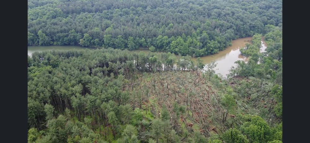
🌪 Damage Analysis: Dayton, Ohio EF4 Tornado [Rivers Edge Apartments] (May 27, 2019) 🌪️
⤵️
⤵️

January 28, 2025 at 3:33 PM
🌪 Damage Analysis: Dayton, Ohio EF4 Tornado [Rivers Edge Apartments] (May 27, 2019) 🌪️
⤵️
⤵️
Happy Thanksgiving, everybody! My plate appears to have been an EF3 (150 mph) DI…


November 29, 2024 at 2:39 AM
Happy Thanksgiving, everybody! My plate appears to have been an EF3 (150 mph) DI…
As of now, the year 2024 has four recorded EF4 tornadoes. Those being:
1. Elkhorn, NE - Modale, IA | 4/26
2. Marietta, OK | 4/27
3. Barnsdall, OK | 5/6
4. Greenfield, IA | 5/21
Though, there are a few more I personally think should've earned a violent rating, here's why.
👇
1. Elkhorn, NE - Modale, IA | 4/26
2. Marietta, OK | 4/27
3. Barnsdall, OK | 5/6
4. Greenfield, IA | 5/21
Though, there are a few more I personally think should've earned a violent rating, here's why.
👇

November 6, 2024 at 4:59 PM
As of now, the year 2024 has four recorded EF4 tornadoes. Those being:
1. Elkhorn, NE - Modale, IA | 4/26
2. Marietta, OK | 4/27
3. Barnsdall, OK | 5/6
4. Greenfield, IA | 5/21
Though, there are a few more I personally think should've earned a violent rating, here's why.
👇
1. Elkhorn, NE - Modale, IA | 4/26
2. Marietta, OK | 4/27
3. Barnsdall, OK | 5/6
4. Greenfield, IA | 5/21
Though, there are a few more I personally think should've earned a violent rating, here's why.
👇
Reposted by Nick Krasznavolgyi
The McCook, Nebraska EF2 tornado from 5/17/19 for #TornadoTuesday

October 22, 2024 at 3:28 PM
The McCook, Nebraska EF2 tornado from 5/17/19 for #TornadoTuesday
Reposted by Nick Krasznavolgyi

Bluesky, meet the night sky.
October 21, 2024 at 2:07 PM
Bluesky, meet the night sky.
Reposted by Nick Krasznavolgyi

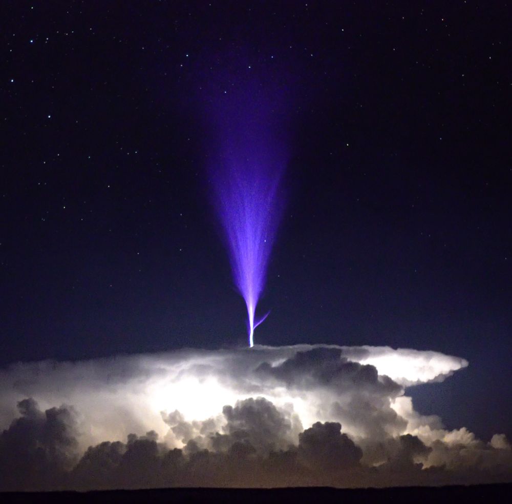
My man @danielshawau.bsky.social said “G’day, get on Bluesky.” First post, a #bluejet
October 20, 2024 at 9:40 PM
My man @danielshawau.bsky.social said “G’day, get on Bluesky.” First post, a #bluejet
Reposted by Nick Krasznavolgyi

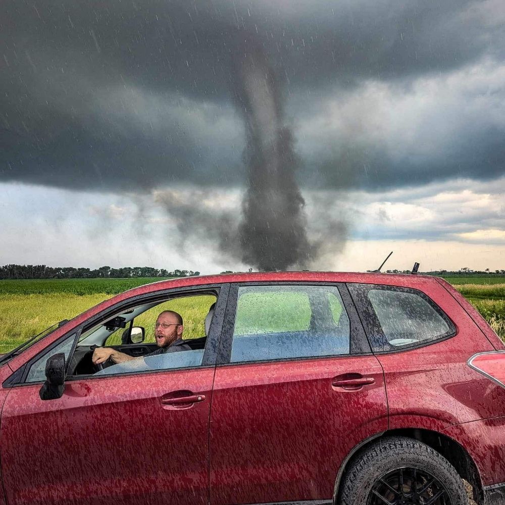
As seen on Twisters.
Still pinching myself ☺️
📍 Lockett, TX | 4.23.21
Still pinching myself ☺️
📍 Lockett, TX | 4.23.21

October 19, 2024 at 4:10 PM
As seen on Twisters.
Still pinching myself ☺️
📍 Lockett, TX | 4.23.21
Still pinching myself ☺️
📍 Lockett, TX | 4.23.21
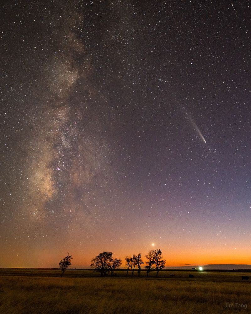
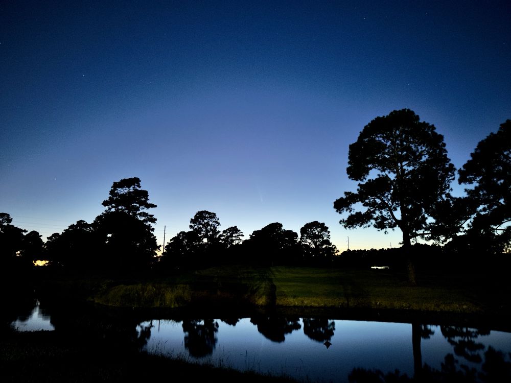
Comet Tsuchinshan–ATLAS viewed from Myrtle Beach, South Carolina a few nights ago!


October 19, 2024 at 3:56 PM
Comet Tsuchinshan–ATLAS viewed from Myrtle Beach, South Carolina a few nights ago!
Reposted by Nick Krasznavolgyi
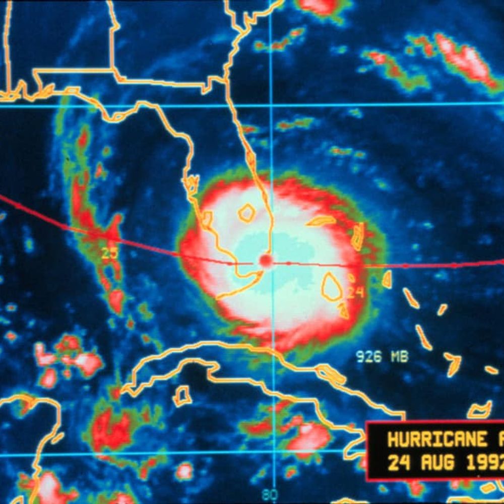
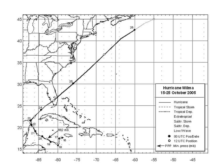
October 19, 2005:
Hurricane Wilma peaked as a Category 5 in the western Caribbean Sea.
The storm's central pressure bottomed-out at 882 millibars, making it the strongest hurricane on record in the Atlantic Ocean. Wilma took only a day to go from 70 to 175 mph.
Hurricane Wilma peaked as a Category 5 in the western Caribbean Sea.
The storm's central pressure bottomed-out at 882 millibars, making it the strongest hurricane on record in the Atlantic Ocean. Wilma took only a day to go from 70 to 175 mph.


October 19, 2024 at 2:43 PM
October 19, 2005:
Hurricane Wilma peaked as a Category 5 in the western Caribbean Sea.
The storm's central pressure bottomed-out at 882 millibars, making it the strongest hurricane on record in the Atlantic Ocean. Wilma took only a day to go from 70 to 175 mph.
Hurricane Wilma peaked as a Category 5 in the western Caribbean Sea.
The storm's central pressure bottomed-out at 882 millibars, making it the strongest hurricane on record in the Atlantic Ocean. Wilma took only a day to go from 70 to 175 mph.
Radar eye candy near Sitka, Alaska right now!

October 19, 2024 at 3:10 AM
Radar eye candy near Sitka, Alaska right now!
Hey everyone! My name is Nick, I'm a senior high school student who resides in the Tampa, Florida area.
I have a particular interest in forensic meteorology, including damage analysis of tornadoes, the EF scale, etc.
I'm a big tornado history nerd and radar buff. I do photography as well.
I have a particular interest in forensic meteorology, including damage analysis of tornadoes, the EF scale, etc.
I'm a big tornado history nerd and radar buff. I do photography as well.
October 17, 2024 at 9:30 PM
Hey everyone! My name is Nick, I'm a senior high school student who resides in the Tampa, Florida area.
I have a particular interest in forensic meteorology, including damage analysis of tornadoes, the EF scale, etc.
I'm a big tornado history nerd and radar buff. I do photography as well.
I have a particular interest in forensic meteorology, including damage analysis of tornadoes, the EF scale, etc.
I'm a big tornado history nerd and radar buff. I do photography as well.
Reposted by Nick Krasznavolgyi

Where the streets have no name ☄️

October 17, 2024 at 5:10 PM
Where the streets have no name ☄️