


Nick Cutler
@ncutler.bsky.social
Physical geographer interested in long-term ecological change, particularly in soil and plant communities, and the ecological impacts of volcanic processes. Often in Iceland.
Reposted by Nick Cutler
Old school #DataViz? In a way.
This WA Geological Survey plate map shows the time of first ashfall from Mount St. Helens on May 18, 1980.
Isochron lines show the ash cloud’s eastward push across the Pacific Northwest, stretching into the morning hours of Monday, May 19.
This WA Geological Survey plate map shows the time of first ashfall from Mount St. Helens on May 18, 1980.
Isochron lines show the ash cloud’s eastward push across the Pacific Northwest, stretching into the morning hours of Monday, May 19.

January 31, 2026 at 3:49 AM
Old school #DataViz? In a way.
This WA Geological Survey plate map shows the time of first ashfall from Mount St. Helens on May 18, 1980.
Isochron lines show the ash cloud’s eastward push across the Pacific Northwest, stretching into the morning hours of Monday, May 19.
This WA Geological Survey plate map shows the time of first ashfall from Mount St. Helens on May 18, 1980.
Isochron lines show the ash cloud’s eastward push across the Pacific Northwest, stretching into the morning hours of Monday, May 19.
One of the better sunsets observed from my office at @ncl-geography.bsky.social

January 15, 2026 at 4:28 PM
One of the better sunsets observed from my office at @ncl-geography.bsky.social
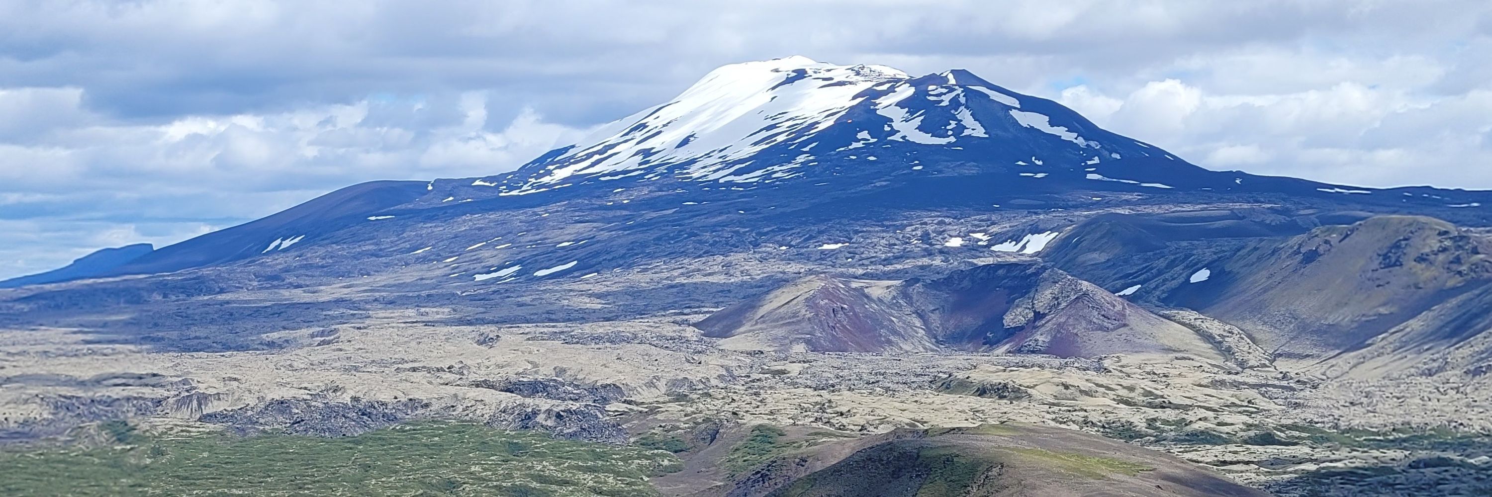
OTD 2020: I was doing fieldwork in Patagonia. I hope my colleagues @iceybethan.bsky.social & @christinebatchelor.bsky.social - currently in Patagonia - are enjoying similarly gorgeous landscapes!


January 9, 2026 at 6:30 PM
OTD 2020: I was doing fieldwork in Patagonia. I hope my colleagues @iceybethan.bsky.social & @christinebatchelor.bsky.social - currently in Patagonia - are enjoying similarly gorgeous landscapes!
Surf's up! Hardy surfers at Whitley Bay yesterday evening. The sea temperature is around 8 degrees...so 10 degrees warmer than the air


January 5, 2026 at 6:29 PM
Surf's up! Hardy surfers at Whitley Bay yesterday evening. The sea temperature is around 8 degrees...so 10 degrees warmer than the air
Bumper berry crop in autumn = homemade sloe gin at Christmas

December 21, 2025 at 2:51 PM
Bumper berry crop in autumn = homemade sloe gin at Christmas
Short stay in Edinburgh. Can't quite believe I used to live in this beautiful city

December 20, 2025 at 10:31 AM
Short stay in Edinburgh. Can't quite believe I used to live in this beautiful city
The sunrise over the North Sea this morning was special. Ten minutes later it was over.


December 11, 2025 at 9:10 AM
The sunrise over the North Sea this morning was special. Ten minutes later it was over.
Reposted by Nick Cutler
Two weeks until our 2/12 PhD funding deadline! If you’re interested in a cryptotephra research project and joining @camtephra.bsky.social there’s still time drop me an email to discuss your ideas.
Dept funding info: www.geog.cam.ac.uk/postgraduate...
NERC DLA: nercdtp.esc.cam.ac.uk/StaffDirecto...
Dept funding info: www.geog.cam.ac.uk/postgraduate...
NERC DLA: nercdtp.esc.cam.ac.uk/StaffDirecto...


November 14, 2025 at 1:10 PM
Two weeks until our 2/12 PhD funding deadline! If you’re interested in a cryptotephra research project and joining @camtephra.bsky.social there’s still time drop me an email to discuss your ideas.
Dept funding info: www.geog.cam.ac.uk/postgraduate...
NERC DLA: nercdtp.esc.cam.ac.uk/StaffDirecto...
Dept funding info: www.geog.cam.ac.uk/postgraduate...
NERC DLA: nercdtp.esc.cam.ac.uk/StaffDirecto...
Reposted by Nick Cutler
Thrilled & honored to be included in the @clarivate.com Highly Cited Researcher List 2025! 🚀
Huge thanks to my collaborators & the present & past members of the @BioFunLab
Proud to contribute to the international visibility of @irnase.bsky.social & @csic.es
clarivate.com/highly-cited...
Huge thanks to my collaborators & the present & past members of the @BioFunLab
Proud to contribute to the international visibility of @irnase.bsky.social & @csic.es
clarivate.com/highly-cited...

Clarivate Highly Cited Researchers 2025
The Highly Cited Researchers 2025 list identifies and celebrates individuals who have demonstrated significant and broad influence in their fields of research. Through rigorous selection criteria and ...
clarivate.com
November 14, 2025 at 2:31 PM
Thrilled & honored to be included in the @clarivate.com Highly Cited Researcher List 2025! 🚀
Huge thanks to my collaborators & the present & past members of the @BioFunLab
Proud to contribute to the international visibility of @irnase.bsky.social & @csic.es
clarivate.com/highly-cited...
Huge thanks to my collaborators & the present & past members of the @BioFunLab
Proud to contribute to the international visibility of @irnase.bsky.social & @csic.es
clarivate.com/highly-cited...
Primary sucession...in Manchester! The Castlefield Viaduct was abandoned for much of the 20th Century and nature took over. Now an outstanding example of urban biodiversity @nationaltrust.org.uk


November 10, 2025 at 7:22 PM
Primary sucession...in Manchester! The Castlefield Viaduct was abandoned for much of the 20th Century and nature took over. Now an outstanding example of urban biodiversity @nationaltrust.org.uk
Hard to disagree with this sentiment


November 6, 2025 at 9:39 AM
Hard to disagree with this sentiment
Francis Crick, Nobel Prize winner who co-discovered the structure of DNA, "never had to teach or grapple with university administration: he applied for a grant only once in his life."
www.nature.com/articles/d41...
No information on the outcome of his application...
www.nature.com/articles/d41...
No information on the outcome of his application...

Sex, drugs and the conscious brain: Francis Crick beyond the double helix
A thoroughly researched account of the history and relationships that shaped the scientist who co-discovered the structure of DNA.
www.nature.com
November 3, 2025 at 12:36 PM
Francis Crick, Nobel Prize winner who co-discovered the structure of DNA, "never had to teach or grapple with university administration: he applied for a grant only once in his life."
www.nature.com/articles/d41...
No information on the outcome of his application...
www.nature.com/articles/d41...
No information on the outcome of his application...
Reposted by Nick Cutler

📢Are you interested in studying for a PhD in the environmental sciences?
👉🏻Consider joining our vibrant Physical Geography community at Newcastle University for a funded PhD studentship. We have 9 new exciting opportunities. See more details on our LinkedIn Page: www.linkedin.com/posts/geogra...
👉🏻Consider joining our vibrant Physical Geography community at Newcastle University for a funded PhD studentship. We have 9 new exciting opportunities. See more details on our LinkedIn Page: www.linkedin.com/posts/geogra...


November 3, 2025 at 11:26 AM
📢Are you interested in studying for a PhD in the environmental sciences?
👉🏻Consider joining our vibrant Physical Geography community at Newcastle University for a funded PhD studentship. We have 9 new exciting opportunities. See more details on our LinkedIn Page: www.linkedin.com/posts/geogra...
👉🏻Consider joining our vibrant Physical Geography community at Newcastle University for a funded PhD studentship. We have 9 new exciting opportunities. See more details on our LinkedIn Page: www.linkedin.com/posts/geogra...
New PhD project with me, Althea Davies and Louise de Raad of Zulu Ecosystems: "The legacy of lost woods: soil microbial communities and the regeneration of the Caledonian Forest".
Full details here: iapetus.ac.uk/studentships...
Full details here: iapetus.ac.uk/studentships...

The legacy of lost woods: soil microbial communities and the regeneration of the Caledonian Forest
iapetus.ac.uk
October 28, 2025 at 3:21 PM
New PhD project with me, Althea Davies and Louise de Raad of Zulu Ecosystems: "The legacy of lost woods: soil microbial communities and the regeneration of the Caledonian Forest".
Full details here: iapetus.ac.uk/studentships...
Full details here: iapetus.ac.uk/studentships...
Well, this looks interesting...and highly relevant to my @royalsociety.org International Exchange project with Dr Jenny Zambrano of @pullman.wsu.edu

🌱🌋 A greenhouse experiment led by Scripps Oceanography & @unigreifswald.bsky.social has uncovered a powerful new way volcanoes give life to the Earth: volcanic ash can triple plant productivity by transforming the microbiome, reshaping entire soil ecosystems. Dig in: scripps.ucsd.edu/news/volcani...

Volcanic Ash Supercharges Plant Growth and Rebuilds Soil Life
A collaboration between scientists at UC San Diego’s Scripps Institution of Oceanography and the University of Greifswald in Germany has uncovered a powerful new way volcanoes give life to the Earth: ...
scripps.ucsd.edu
October 15, 2025 at 9:08 AM
Well, this looks interesting...and highly relevant to my @royalsociety.org International Exchange project with Dr Jenny Zambrano of @pullman.wsu.edu
Reposted by Nick Cutler
Tomorrow, we will talk about this photo.

October 9, 2025 at 1:09 AM
Tomorrow, we will talk about this photo.
A sunny Sunday in Newcastle, along the Ouseburn


September 28, 2025 at 8:02 PM
A sunny Sunday in Newcastle, along the Ouseburn
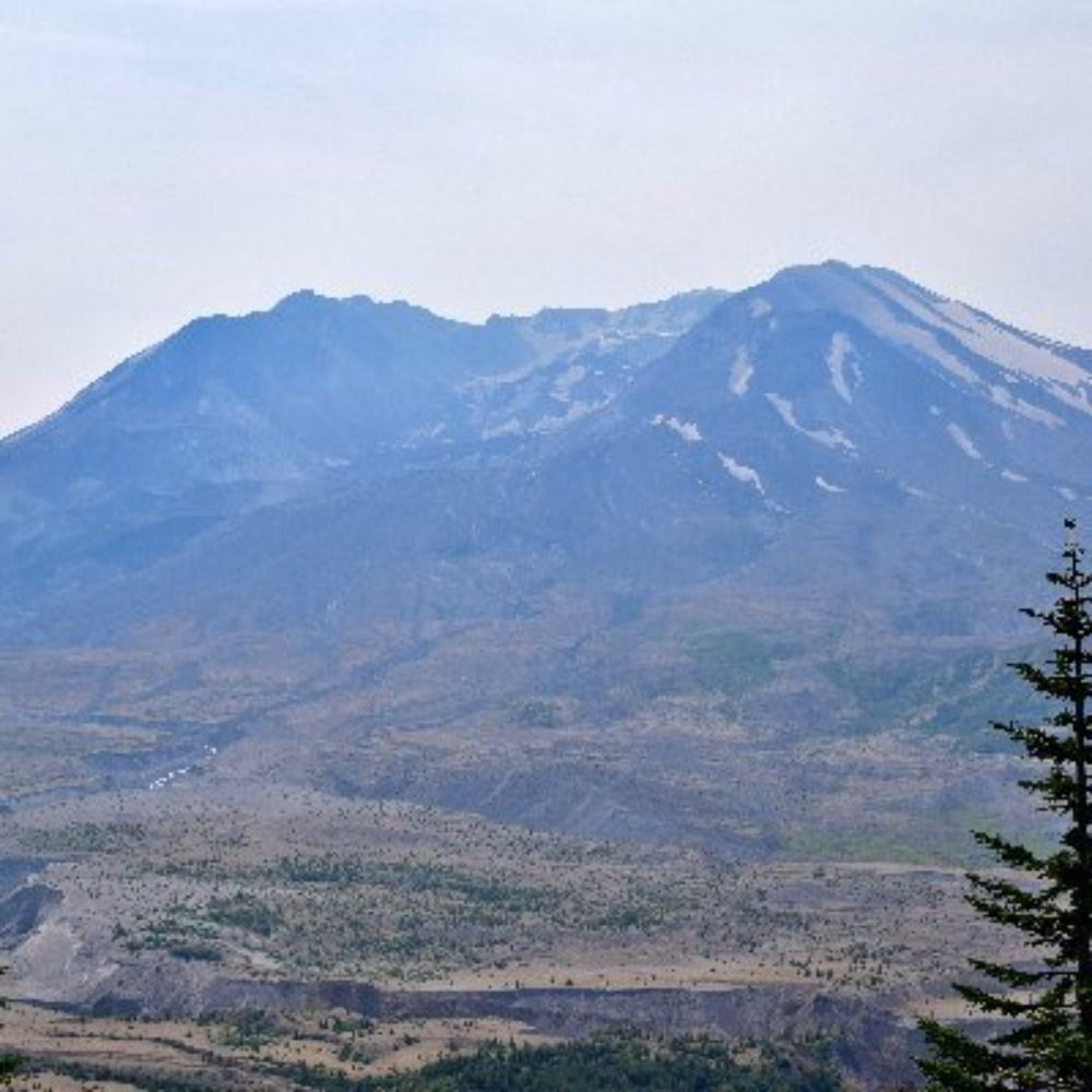
Resuspended volcanic ash: a niche interest of mine!
www.cnn.com/2025/09/17/w...
www.cnn.com/2025/09/17/w...

No, Mount St. Helens isn’t erupting again. It’s just stirring up leftover ash 45 years after ‘the big one’ | CNN
For a moment, it seemed like a blast from the past: a plume over Mount St. Helens on Tuesday looked like the volcano might be erupting again. But fortunately, this was not an eruption — just a wind-wh...
www.cnn.com
September 18, 2025 at 9:15 AM
Resuspended volcanic ash: a niche interest of mine!
www.cnn.com/2025/09/17/w...
www.cnn.com/2025/09/17/w...
St Andrews, South Lopham looked very pretty in the moonlight

September 7, 2025 at 7:57 AM
St Andrews, South Lopham looked very pretty in the moonlight
The Plough over Norfolk last night

September 7, 2025 at 7:56 AM
The Plough over Norfolk last night
At Churchill College for a brief visit. Wonderful to be back: like coming home.

September 5, 2025 at 10:10 PM
At Churchill College for a brief visit. Wonderful to be back: like coming home.
OTD in 2010 I was fortunate enough to visit the cupola on top of the Radcliffe Camera during renovation works: a once in a lifetime opportunity. The views of Oxford were quite something.


August 31, 2025 at 2:41 PM
OTD in 2010 I was fortunate enough to visit the cupola on top of the Radcliffe Camera during renovation works: a once in a lifetime opportunity. The views of Oxford were quite something.
A lot of great experiences on my recent trip to Australia. But swimming with humpback whales on the Ningaloo Reef was definitely one of the highlights.
August 20, 2025 at 9:49 PM
A lot of great experiences on my recent trip to Australia. But swimming with humpback whales on the Ningaloo Reef was definitely one of the highlights.
You'll be missed, Andy: a terrific colleague and great geographer
That’s a wrap after 21 great years at Newcastle University! Although retired from full-time work I'll not be retiring from academia and am looking forward to working on a number of collaborative research projects.


July 31, 2025 at 11:40 PM
You'll be missed, Andy: a terrific colleague and great geographer
Reposted by Nick Cutler
Thrilled to have received the Richardson Medal from the @igsoc.bsky.social at the IGS symposium last night. I’m so touched and thank you to everyone who nominated me ❤️


July 25, 2025 at 8:44 AM
Thrilled to have received the Richardson Medal from the @igsoc.bsky.social at the IGS symposium last night. I’m so touched and thank you to everyone who nominated me ❤️