


Mona Hemmati
@monahemmati.bsky.social
Adjunct Associate Research Scientist @LamontEarth @ColumbiaClimate | Studying climate with a focus on #ExtremeEvents | Views are my own.
Millions of Iranians are risking their lives to demand freedom and an end to the brutality of the Islamic Republic.
13 days of courage. 13 days of resistance.
The regime’s response? Internet blackouts, repression, and killings.
#Iran #IranRevolution #IranProtests2026 #IranInternetShutdown
13 days of courage. 13 days of resistance.
The regime’s response? Internet blackouts, repression, and killings.
#Iran #IranRevolution #IranProtests2026 #IranInternetShutdown

January 9, 2026 at 12:12 PM
Millions of Iranians are risking their lives to demand freedom and an end to the brutality of the Islamic Republic.
13 days of courage. 13 days of resistance.
The regime’s response? Internet blackouts, repression, and killings.
#Iran #IranRevolution #IranProtests2026 #IranInternetShutdown
13 days of courage. 13 days of resistance.
The regime’s response? Internet blackouts, repression, and killings.
#Iran #IranRevolution #IranProtests2026 #IranInternetShutdown
Reposted by Mona Hemmati

Some reflections after returning back from a conference at which I and 20,000 colleagues learned that the Trump administration intends to dismantle #NCAR. This outrage should not happen. deepconvection.substack.com/p/save-ncar

Save NCAR
Field notes from New Orleans, where I and 20,000 colleagues learned that Trump intends to destroy the National Center for Atmospheric Research.
deepconvection.substack.com
December 21, 2025 at 7:25 PM
Some reflections after returning back from a conference at which I and 20,000 colleagues learned that the Trump administration intends to dismantle #NCAR. This outrage should not happen. deepconvection.substack.com/p/save-ncar
Heading to #AGU25 on this beautiful snowy morning in NYC ❄️ Looking forward to an exciting lineup of talks and catching up with colleagues.

December 14, 2025 at 12:53 PM
Heading to #AGU25 on this beautiful snowy morning in NYC ❄️ Looking forward to an exciting lineup of talks and catching up with colleagues.
Reposted by Mona Hemmati

*Busy* Monday for me at #AGU25
NH12B-05 11:12-11:22 Applying the Swiss Cheese Model to Wildfire Risk Management in the Built Environment
TH15B 6-7 Town Hall Hurricane Katrina 20 Year Later
then RUNNING to Atmos Science section Student/Early Career mixer to talk cat modeling 7-8:30
NH12B-05 11:12-11:22 Applying the Swiss Cheese Model to Wildfire Risk Management in the Built Environment
TH15B 6-7 Town Hall Hurricane Katrina 20 Year Later
then RUNNING to Atmos Science section Student/Early Career mixer to talk cat modeling 7-8:30
December 12, 2025 at 8:03 PM
*Busy* Monday for me at #AGU25
NH12B-05 11:12-11:22 Applying the Swiss Cheese Model to Wildfire Risk Management in the Built Environment
TH15B 6-7 Town Hall Hurricane Katrina 20 Year Later
then RUNNING to Atmos Science section Student/Early Career mixer to talk cat modeling 7-8:30
NH12B-05 11:12-11:22 Applying the Swiss Cheese Model to Wildfire Risk Management in the Built Environment
TH15B 6-7 Town Hall Hurricane Katrina 20 Year Later
then RUNNING to Atmos Science section Student/Early Career mixer to talk cat modeling 7-8:30
Today marks the official close of the 2025 Atlantic #hurricane season — a season defined by striking contrasts. From an unusually quiet peak to sudden bursts of extreme intensity, 2025 reinforced a critical lesson: a low storm count doesn't mean low risk.

November 30, 2025 at 4:39 PM
Today marks the official close of the 2025 Atlantic #hurricane season — a season defined by striking contrasts. From an unusually quiet peak to sudden bursts of extreme intensity, 2025 reinforced a critical lesson: a low storm count doesn't mean low risk.
#Melissa has set new benchmarks on several fronts.

Melissa Records:
Strongest Atlantic Landfall (Tie)
3rd Strongest Atlantic Hurricane (Tie)
World Record Driest/ Clearest Eye
3rd 2025 Cat 5 (2nd most)
4th Extreme Rapid Intensification Episide of 2025 (tied for 1st place)
1/
Strongest Atlantic Landfall (Tie)
3rd Strongest Atlantic Hurricane (Tie)
World Record Driest/ Clearest Eye
3rd 2025 Cat 5 (2nd most)
4th Extreme Rapid Intensification Episide of 2025 (tied for 1st place)
1/

October 28, 2025 at 10:54 PM
#Melissa has set new benchmarks on several fronts.
Last year, I experienced Cat 1 Hurricane #Beryl making landfall in Houston. It was both terrifying and fascinating—an intense reminder of nature’s power and how small we can feel in its presence. I can’t imagine what the people of Jamaica and other countries in #Melissa’s path are going through.
October 28, 2025 at 4:08 PM
Last year, I experienced Cat 1 Hurricane #Beryl making landfall in Houston. It was both terrifying and fascinating—an intense reminder of nature’s power and how small we can feel in its presence. I can’t imagine what the people of Jamaica and other countries in #Melissa’s path are going through.
#Melissa is undergoing explosive intensification — winds have surged 50 kt in 24 hours, including 35 kt in the last 12!
Jamaica faces a potentially catastrophic impact as the storm nears. And it’s not just the wind — the 4-day rainfall forecast is astronomical, with 30+ inches expected.
Jamaica faces a potentially catastrophic impact as the storm nears. And it’s not just the wind — the 4-day rainfall forecast is astronomical, with 30+ inches expected.
October 26, 2025 at 12:54 PM
#Melissa is undergoing explosive intensification — winds have surged 50 kt in 24 hours, including 35 kt in the last 12!
Jamaica faces a potentially catastrophic impact as the storm nears. And it’s not just the wind — the 4-day rainfall forecast is astronomical, with 30+ inches expected.
Jamaica faces a potentially catastrophic impact as the storm nears. And it’s not just the wind — the 4-day rainfall forecast is astronomical, with 30+ inches expected.
Reposted by Mona Hemmati

ICYMI: This week we released our Natural Catastrophe & Climate Report: Q3 2025
www.ajg.com/gallagherre/...
YTD Totals
Economic Loss: >$214bn (-37% from 10-Yr Avg)
Insured Loss: >$105bn (-8% from 10-Yr Avg)
US billion-dollar economic loss events: 20+ (7th year in a row)
(1/n)
www.ajg.com/gallagherre/...
YTD Totals
Economic Loss: >$214bn (-37% from 10-Yr Avg)
Insured Loss: >$105bn (-8% from 10-Yr Avg)
US billion-dollar economic loss events: 20+ (7th year in a row)
(1/n)

October 17, 2025 at 4:47 PM
ICYMI: This week we released our Natural Catastrophe & Climate Report: Q3 2025
www.ajg.com/gallagherre/...
YTD Totals
Economic Loss: >$214bn (-37% from 10-Yr Avg)
Insured Loss: >$105bn (-8% from 10-Yr Avg)
US billion-dollar economic loss events: 20+ (7th year in a row)
(1/n)
www.ajg.com/gallagherre/...
YTD Totals
Economic Loss: >$214bn (-37% from 10-Yr Avg)
Insured Loss: >$105bn (-8% from 10-Yr Avg)
US billion-dollar economic loss events: 20+ (7th year in a row)
(1/n)
A Nor’easter is battering the East Coast from Virginia to Connecticut, unleashing widespread flood warnings and powerful wind gusts reaching up to 60 mph—especially along the Jersey Shore.
Current projections:
🟪 3 gauges — Major Flood
🟥 17 gauges — Moderate Flood
🟧 40 gauges — Minor Flood
Current projections:
🟪 3 gauges — Major Flood
🟥 17 gauges — Moderate Flood
🟧 40 gauges — Minor Flood

October 13, 2025 at 10:48 AM
A Nor’easter is battering the East Coast from Virginia to Connecticut, unleashing widespread flood warnings and powerful wind gusts reaching up to 60 mph—especially along the Jersey Shore.
Current projections:
🟪 3 gauges — Major Flood
🟥 17 gauges — Moderate Flood
🟧 40 gauges — Minor Flood
Current projections:
🟪 3 gauges — Major Flood
🟥 17 gauges — Moderate Flood
🟧 40 gauges — Minor Flood
Reposted by Mona Hemmati

🚨 Open Call for new Steering Committee Members 🚨
Are you working on #risks from #extremeEvents under #environmentalChange?
Join us as Risk KAN Steering Committee member for the upcoming term: www.risk-kan.org/about-riskka...
www.risk-kan.org
@futureearth.bsky.social @wcrpclimate.bsky.social.
Are you working on #risks from #extremeEvents under #environmentalChange?
Join us as Risk KAN Steering Committee member for the upcoming term: www.risk-kan.org/about-riskka...
www.risk-kan.org
@futureearth.bsky.social @wcrpclimate.bsky.social.

September 8, 2025 at 1:33 PM
🚨 Open Call for new Steering Committee Members 🚨
Are you working on #risks from #extremeEvents under #environmentalChange?
Join us as Risk KAN Steering Committee member for the upcoming term: www.risk-kan.org/about-riskka...
www.risk-kan.org
@futureearth.bsky.social @wcrpclimate.bsky.social.
Are you working on #risks from #extremeEvents under #environmentalChange?
Join us as Risk KAN Steering Committee member for the upcoming term: www.risk-kan.org/about-riskka...
www.risk-kan.org
@futureearth.bsky.social @wcrpclimate.bsky.social.

September 5, 2025 at 10:46 PM
#Erin has formed in the southeastern Atlantic and could potentially become the first hurricane of the season. While it’s still too early to determine if it poses a threat to the U.S. East Coast, conditions are becoming increasingly favorable for further intensification.

August 11, 2025 at 8:30 PM
#Erin has formed in the southeastern Atlantic and could potentially become the first hurricane of the season. While it’s still too early to determine if it poses a threat to the U.S. East Coast, conditions are becoming increasingly favorable for further intensification.
Moderate Risk of Excessive Rainfall Issued!
Affects areas along the I-95 corridor from Washington, D.C. to New York City. Rainfall rates may reach up to 3 inches per hour
Localized totals could exceed 5-8 inches.
Do NOT drive through floodwaters!
Affects areas along the I-95 corridor from Washington, D.C. to New York City. Rainfall rates may reach up to 3 inches per hour
Localized totals could exceed 5-8 inches.
Do NOT drive through floodwaters!


July 31, 2025 at 7:45 PM
Moderate Risk of Excessive Rainfall Issued!
Affects areas along the I-95 corridor from Washington, D.C. to New York City. Rainfall rates may reach up to 3 inches per hour
Localized totals could exceed 5-8 inches.
Do NOT drive through floodwaters!
Affects areas along the I-95 corridor from Washington, D.C. to New York City. Rainfall rates may reach up to 3 inches per hour
Localized totals could exceed 5-8 inches.
Do NOT drive through floodwaters!
Stunning sunrise paints the sky over Newark International Airport.

July 17, 2025 at 9:57 AM
Stunning sunrise paints the sky over Newark International Airport.
Grateful for a few extra days to enjoy Florida after the Symposium on Tropical Cyclone Risk in a Changing Climate. A perfect way to unwind after an intense and inspiring week.
#STCRCC
#STCRCC

June 7, 2025 at 12:16 AM
Grateful for a few extra days to enjoy Florida after the Symposium on Tropical Cyclone Risk in a Changing Climate. A perfect way to unwind after an intense and inspiring week.
#STCRCC
#STCRCC
Reposted by Mona Hemmati
Today is the "official" start to the Atlantic hurricane season. It is impossible to know what exactly will occur, but we can look to sea surface temperatures for clues.
2025 is definitely cooler than 2024 on June 1. Parts of the basin are warmer than recent analog years in 2008 / 2017.
(1/n)
2025 is definitely cooler than 2024 on June 1. Parts of the basin are warmer than recent analog years in 2008 / 2017.
(1/n)

June 1, 2025 at 6:59 PM
Today is the "official" start to the Atlantic hurricane season. It is impossible to know what exactly will occur, but we can look to sea surface temperatures for clues.
2025 is definitely cooler than 2024 on June 1. Parts of the basin are warmer than recent analog years in 2008 / 2017.
(1/n)
2025 is definitely cooler than 2024 on June 1. Parts of the basin are warmer than recent analog years in 2008 / 2017.
(1/n)
Reposted by Mona Hemmati
Today we at Gallagher Re have released an initial assessment that estimates the May 14-20 stretch of US thunderstorms will drive $4-7 billion in insured losses. Uninsured damage is expected to drive the overall direct economic cost higher by at least another billion.
(1/2)
(1/2)

May 22, 2025 at 9:56 PM
Today we at Gallagher Re have released an initial assessment that estimates the May 14-20 stretch of US thunderstorms will drive $4-7 billion in insured losses. Uninsured damage is expected to drive the overall direct economic cost higher by at least another billion.
(1/2)
(1/2)
Moderate Risk (Level 4 of 5) issued for far North Texas, much of Central & Eastern Oklahoma, Southeast Kansas, and the Ozarks today. This continues the string of catastrophic convective storm systems that have battered parts of the U.S. in recent days.
#SevereWeather
#SevereWeather

May 19, 2025 at 3:57 PM
Moderate Risk (Level 4 of 5) issued for far North Texas, much of Central & Eastern Oklahoma, Southeast Kansas, and the Ozarks today. This continues the string of catastrophic convective storm systems that have battered parts of the U.S. in recent days.
#SevereWeather
#SevereWeather
Reposted by Mona Hemmati

Excited to host the first #RiskKAN symposium at @iiasa.ac.at with presentations and a panel on #multi-hazard risks in a changing world on april 28th.
This kicks-off the new #Risk-KAN WG-structure co-chaired by @marleenderuiter.bsky.social, S.Singh and myself.
iiasa.ac.at/events/apr-2...
This kicks-off the new #Risk-KAN WG-structure co-chaired by @marleenderuiter.bsky.social, S.Singh and myself.
iiasa.ac.at/events/apr-2...

1st Risk-KAN Symposium at IIASA
The 1st Risk-KAN Symposium will be held on the 28th of April at the International Institute for Applied Systems Analysis (IIASA).
iiasa.ac.at
April 23, 2025 at 12:25 PM
Excited to host the first #RiskKAN symposium at @iiasa.ac.at with presentations and a panel on #multi-hazard risks in a changing world on april 28th.
This kicks-off the new #Risk-KAN WG-structure co-chaired by @marleenderuiter.bsky.social, S.Singh and myself.
iiasa.ac.at/events/apr-2...
This kicks-off the new #Risk-KAN WG-structure co-chaired by @marleenderuiter.bsky.social, S.Singh and myself.
iiasa.ac.at/events/apr-2...
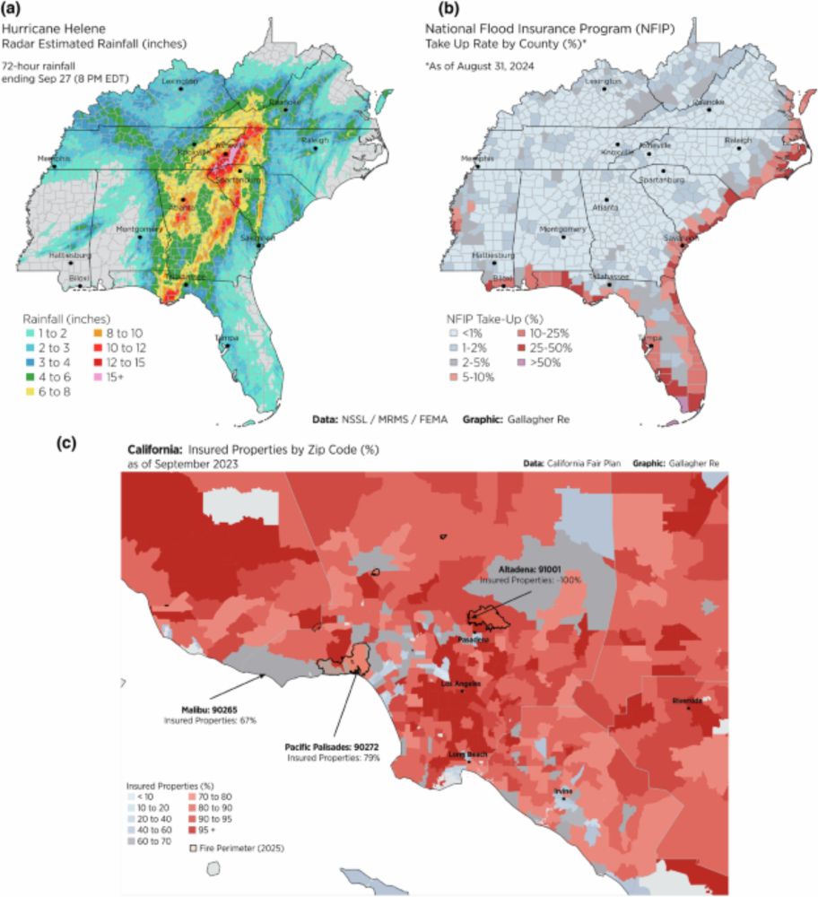
The gap between where people live and where insurance remains available is widening across the U.S. We explore this in our recent paper, “The Growing Void in the U.S. Homeowners Insurance Market: Who Should Bear the Rising Cost of Climate Change” co-authored with Ian Gray @stevebowen.bsky.social


April 14, 2025 at 2:21 PM
The gap between where people live and where insurance remains available is widening across the U.S. We explore this in our recent paper, “The Growing Void in the U.S. Homeowners Insurance Market: Who Should Bear the Rising Cost of Climate Change” co-authored with Ian Gray @stevebowen.bsky.social
Reposted by Mona Hemmati

Ideas for reform: stronger building codes, not developing risky areas, and a federal catastrophe backstop program designed for highly climate-vulnerable areas—covering those rare tail events with excessive losses once they exceed a prescribed limit, modeled on the Terrorism Risk Insurance Act (TRIA)
NEW PUBLICATION ALERT
"The growing void in the US homeowners insurance market: who should bear the rising cost of climate change?
Co-authors: @monahemmati.bsky.social & Ian Gray
(1/n)
www.nature.com/articles/s44...
"The growing void in the US homeowners insurance market: who should bear the rising cost of climate change?
Co-authors: @monahemmati.bsky.social & Ian Gray
(1/n)
www.nature.com/articles/s44...
The growing void in the U.S. homeowners insurance market: who should bear the rising cost of climate change? - npj Climate Action
npj Climate Action - The growing void in the U.S. homeowners insurance market: who should bear the rising cost of climate change?
www.nature.com
April 14, 2025 at 2:07 PM
Ideas for reform: stronger building codes, not developing risky areas, and a federal catastrophe backstop program designed for highly climate-vulnerable areas—covering those rare tail events with excessive losses once they exceed a prescribed limit, modeled on the Terrorism Risk Insurance Act (TRIA)
Reposted by Mona Hemmati
NEW PUBLICATION ALERT
"The growing void in the US homeowners insurance market: who should bear the rising cost of climate change?
Co-authors: @monahemmati.bsky.social & Ian Gray
(1/n)
www.nature.com/articles/s44...
"The growing void in the US homeowners insurance market: who should bear the rising cost of climate change?
Co-authors: @monahemmati.bsky.social & Ian Gray
(1/n)
www.nature.com/articles/s44...
The growing void in the U.S. homeowners insurance market: who should bear the rising cost of climate change? - npj Climate Action
npj Climate Action - The growing void in the U.S. homeowners insurance market: who should bear the rising cost of climate change?
www.nature.com
April 14, 2025 at 11:53 AM
NEW PUBLICATION ALERT
"The growing void in the US homeowners insurance market: who should bear the rising cost of climate change?
Co-authors: @monahemmati.bsky.social & Ian Gray
(1/n)
www.nature.com/articles/s44...
"The growing void in the US homeowners insurance market: who should bear the rising cost of climate change?
Co-authors: @monahemmati.bsky.social & Ian Gray
(1/n)
www.nature.com/articles/s44...

A powerful weather system is sweeping across much of the U.S., bringing a range of extreme hazards. An extremely critical wildfire threat—the highest level—extends unusually far east into Texas and Oklahoma. Meanwhile, the central U.S. faces an increased risk of tornadoes and severe thunderstorms.


March 13, 2025 at 9:01 PM
A powerful weather system is sweeping across much of the U.S., bringing a range of extreme hazards. An extremely critical wildfire threat—the highest level—extends unusually far east into Texas and Oklahoma. Meanwhile, the central U.S. faces an increased risk of tornadoes and severe thunderstorms.