


Met4Cast
@met4cast.net
UK WEATHER UPDATES | No drama, just weather | Making complex weather understandable | 20+ years of studying | Sensible forecasts without the hype ❌
This shows the predicted 2M temperatures for London.
A marked decline as we go through the rest of January but there’s a bi-modal split in the extended between very cold (ice days) and something less cold.
Much of this is dependent on the alignment of high & low pressure 📈📉
A marked decline as we go through the rest of January but there’s a bi-modal split in the extended between very cold (ice days) and something less cold.
Much of this is dependent on the alignment of high & low pressure 📈📉

January 17, 2026 at 1:38 PM
This shows the predicted 2M temperatures for London.
A marked decline as we go through the rest of January but there’s a bi-modal split in the extended between very cold (ice days) and something less cold.
Much of this is dependent on the alignment of high & low pressure 📈📉
A marked decline as we go through the rest of January but there’s a bi-modal split in the extended between very cold (ice days) and something less cold.
Much of this is dependent on the alignment of high & low pressure 📈📉
Shannon entropy is high.
Huge spread in the extended with a few very cold ensembles beginning to appear.
Equally quite a few less cold solutions still evident too.
Huge spread in the extended with a few very cold ensembles beginning to appear.
Equally quite a few less cold solutions still evident too.

January 13, 2026 at 10:15 PM
Shannon entropy is high.
Huge spread in the extended with a few very cold ensembles beginning to appear.
Equally quite a few less cold solutions still evident too.
Huge spread in the extended with a few very cold ensembles beginning to appear.
Equally quite a few less cold solutions still evident too.
Given the possibility of X being banned I’ve decided to become more active on here.
- Weather updates
- Model commentary
- Long range thoughts
Potential for a return it cold weather beyond the 22nd January.
- Weather updates
- Model commentary
- Long range thoughts
Potential for a return it cold weather beyond the 22nd January.

a bush covered in snow with a few branches visible in the foreground
ALT: a bush covered in snow with a few branches visible in the foreground
media.tenor.com
January 13, 2026 at 11:22 AM
Given the possibility of X being banned I’ve decided to become more active on here.
- Weather updates
- Model commentary
- Long range thoughts
Potential for a return it cold weather beyond the 22nd January.
- Weather updates
- Model commentary
- Long range thoughts
Potential for a return it cold weather beyond the 22nd January.
The 06z GFS showing what *could* happen if things align correctly.
Bitterly cold easterly wind, streamers & heavy snowfall and a completely cut off Griceland high.
Cold weather would be locked in.
A more extreme run, I’d imagine.
Bitterly cold easterly wind, streamers & heavy snowfall and a completely cut off Griceland high.
Cold weather would be locked in.
A more extreme run, I’d imagine.


January 13, 2026 at 11:20 AM
The 06z GFS showing what *could* happen if things align correctly.
Bitterly cold easterly wind, streamers & heavy snowfall and a completely cut off Griceland high.
Cold weather would be locked in.
A more extreme run, I’d imagine.
Bitterly cold easterly wind, streamers & heavy snowfall and a completely cut off Griceland high.
Cold weather would be locked in.
A more extreme run, I’d imagine.
The Atlantic low pressure conveyor belt is in full swing for the next 2 weeks.
Low after low pushing in towards the UK bringing potentially 100-400mm of rainfall across western hills.
Very, very wet.
Low after low pushing in towards the UK bringing potentially 100-400mm of rainfall across western hills.
Very, very wet.

December 8, 2025 at 12:45 PM
The Atlantic low pressure conveyor belt is in full swing for the next 2 weeks.
Low after low pushing in towards the UK bringing potentially 100-400mm of rainfall across western hills.
Very, very wet.
Low after low pushing in towards the UK bringing potentially 100-400mm of rainfall across western hills.
Very, very wet.
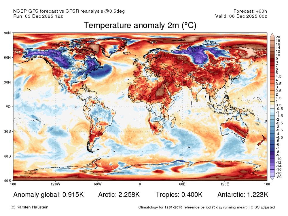
It is December, right?
Much of the Northern Hemisphere continues to be significantly above average.
El Niño next year is almost certainly going to set new global temperature records 📈
Much of the Northern Hemisphere continues to be significantly above average.
El Niño next year is almost certainly going to set new global temperature records 📈
December 3, 2025 at 6:28 PM
It is December, right?
Much of the Northern Hemisphere continues to be significantly above average.
El Niño next year is almost certainly going to set new global temperature records 📈
Much of the Northern Hemisphere continues to be significantly above average.
El Niño next year is almost certainly going to set new global temperature records 📈
This is a good outlook for people who pay their own heating bills.
Average or mild for the foreseeable with no sign of anything particularly cold 📈
Potentially a very wet outlook.
Average or mild for the foreseeable with no sign of anything particularly cold 📈
Potentially a very wet outlook.

December 3, 2025 at 3:33 PM
This is a good outlook for people who pay their own heating bills.
Average or mild for the foreseeable with no sign of anything particularly cold 📈
Potentially a very wet outlook.
Average or mild for the foreseeable with no sign of anything particularly cold 📈
Potentially a very wet outlook.
I really hope the Met Office see some sense and scrap this new app.
The design remains awful, completely lacking in data and.. worse still, this is what the warnings look like. How are you supposed to see which warning is which?
Just awful.
The design remains awful, completely lacking in data and.. worse still, this is what the warnings look like. How are you supposed to see which warning is which?
Just awful.

November 17, 2025 at 12:17 PM
I really hope the Met Office see some sense and scrap this new app.
The design remains awful, completely lacking in data and.. worse still, this is what the warnings look like. How are you supposed to see which warning is which?
Just awful.
The design remains awful, completely lacking in data and.. worse still, this is what the warnings look like. How are you supposed to see which warning is which?
Just awful.
A somewhat unfortunate drawing of the lines there..
November 17, 2025 at 11:20 AM
A somewhat unfortunate drawing of the lines there..
🚨 Locally severe weather possible tomorrow.
An easterly flow within the broader area of rainfall will intensify rainfall along eastern Welsh hills via orographic lift leading to a lot of water flowing into rivers downhill.
Totals of >100mm possible locally.
An easterly flow within the broader area of rainfall will intensify rainfall along eastern Welsh hills via orographic lift leading to a lot of water flowing into rivers downhill.
Totals of >100mm possible locally.

November 13, 2025 at 2:43 PM
🚨 Locally severe weather possible tomorrow.
An easterly flow within the broader area of rainfall will intensify rainfall along eastern Welsh hills via orographic lift leading to a lot of water flowing into rivers downhill.
Totals of >100mm possible locally.
An easterly flow within the broader area of rainfall will intensify rainfall along eastern Welsh hills via orographic lift leading to a lot of water flowing into rivers downhill.
Totals of >100mm possible locally.
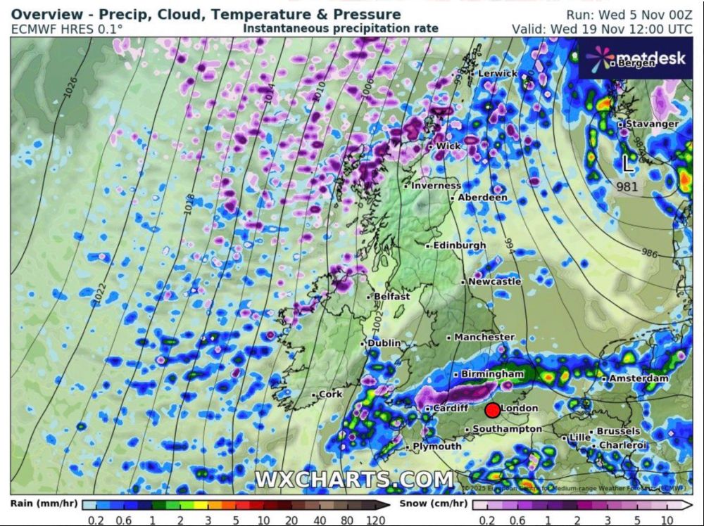
Potentially quite a significant rain event shaping up for Friday.
A waving weather front could bring locally very high totals across the hills of Wales for example with totals likely exceeding 100mm and widely 30-50mm across central England.
Would expect Met Office warnings ⚠️
A waving weather front could bring locally very high totals across the hills of Wales for example with totals likely exceeding 100mm and widely 30-50mm across central England.
Would expect Met Office warnings ⚠️


November 12, 2025 at 8:40 AM
Potentially quite a significant rain event shaping up for Friday.
A waving weather front could bring locally very high totals across the hills of Wales for example with totals likely exceeding 100mm and widely 30-50mm across central England.
Would expect Met Office warnings ⚠️
A waving weather front could bring locally very high totals across the hills of Wales for example with totals likely exceeding 100mm and widely 30-50mm across central England.
Would expect Met Office warnings ⚠️
Absolute textbook example of anti-cyclonic wave breaking in the next few days leading to a cut off area of high pressure over Greenland.
November 11, 2025 at 5:51 PM
Absolute textbook example of anti-cyclonic wave breaking in the next few days leading to a cut off area of high pressure over Greenland.
Cold December?
MJO eastwards propagation and the associated +ve AAM tendency has driven a Pac Jet extension resulting in Atlantic / Greenland blocking next week.
This block will likely relax by the 26th/27th with a brief Atlantic interlude before further blocking develops into December.
MJO eastwards propagation and the associated +ve AAM tendency has driven a Pac Jet extension resulting in Atlantic / Greenland blocking next week.
This block will likely relax by the 26th/27th with a brief Atlantic interlude before further blocking develops into December.


November 11, 2025 at 3:36 PM
Cold December?
MJO eastwards propagation and the associated +ve AAM tendency has driven a Pac Jet extension resulting in Atlantic / Greenland blocking next week.
This block will likely relax by the 26th/27th with a brief Atlantic interlude before further blocking develops into December.
MJO eastwards propagation and the associated +ve AAM tendency has driven a Pac Jet extension resulting in Atlantic / Greenland blocking next week.
This block will likely relax by the 26th/27th with a brief Atlantic interlude before further blocking develops into December.
❄️❄️
Cold and potentially wintry weather arrives next week so naturally I've been dusting off and tweaking the snow graphics.
This is an example, but probably also does well to highlight the broader snow risks next week.
Cold and potentially wintry weather arrives next week so naturally I've been dusting off and tweaking the snow graphics.
This is an example, but probably also does well to highlight the broader snow risks next week.

November 11, 2025 at 2:48 PM
❄️❄️
Cold and potentially wintry weather arrives next week so naturally I've been dusting off and tweaking the snow graphics.
This is an example, but probably also does well to highlight the broader snow risks next week.
Cold and potentially wintry weather arrives next week so naturally I've been dusting off and tweaking the snow graphics.
This is an example, but probably also does well to highlight the broader snow risks next week.
Potential for some locally high rainfall totals across Wales in the coming days as a frontal wave pushes in.
Localised flooding / swollen rivers a possibility.
(The WxCharts redesign is very nice)
Localised flooding / swollen rivers a possibility.
(The WxCharts redesign is very nice)


November 11, 2025 at 1:54 PM
Potential for some locally high rainfall totals across Wales in the coming days as a frontal wave pushes in.
Localised flooding / swollen rivers a possibility.
(The WxCharts redesign is very nice)
Localised flooding / swollen rivers a possibility.
(The WxCharts redesign is very nice)
Unpopular opinion: Using the word "uppers" to describe 85hPa temperatures doesn't make any sense.
November 10, 2025 at 10:37 AM
Unpopular opinion: Using the word "uppers" to describe 85hPa temperatures doesn't make any sense.
Reposted by Met4Cast

We’ve built our own Snow Tracker. Bookmark it now and report your snowfall this winter. Learn more below 👇 blog.snowwatch.org/pr/from-flak...

From Flakes to Facts: Our Snow Tracker • Snow Watch Blog
We love to see your snow reports, but the social media space has changed with the sale of Twitter (hem, "X") to Elon. This saw disruption to many ...
blog.snowwatch.org
November 6, 2025 at 2:05 PM
We’ve built our own Snow Tracker. Bookmark it now and report your snowfall this winter. Learn more below 👇 blog.snowwatch.org/pr/from-flak...
The overnight ECM manages to find the cold.. ❄️
Still too far off to be chasing any cold with little support but does show that cold / snow is possible at the time of year we’re keeping an eye on.
Still too far off to be chasing any cold with little support but does show that cold / snow is possible at the time of year we’re keeping an eye on.

November 5, 2025 at 10:13 AM
The overnight ECM manages to find the cold.. ❄️
Still too far off to be chasing any cold with little support but does show that cold / snow is possible at the time of year we’re keeping an eye on.
Still too far off to be chasing any cold with little support but does show that cold / snow is possible at the time of year we’re keeping an eye on.
Beautiful example of a Rex Block on the GFS today.

November 4, 2025 at 8:54 PM
Beautiful example of a Rex Block on the GFS today.
Very interesting u-wind profile from the EC46 last night. Early December is usually a time when the sPV is strengthening so to see not only a significant weakening but many members going into major SSW territory is very interesting.
Last major SSW in early Decwas 1987.
Last Dec SSW was 2001.
Last major SSW in early Decwas 1987.
Last Dec SSW was 2001.

November 4, 2025 at 9:03 AM
Very interesting u-wind profile from the EC46 last night. Early December is usually a time when the sPV is strengthening so to see not only a significant weakening but many members going into major SSW territory is very interesting.
Last major SSW in early Decwas 1987.
Last Dec SSW was 2001.
Last major SSW in early Decwas 1987.
Last Dec SSW was 2001.
Blocky.
A Pacific jet extension associated with a recent strong +EAMT event will generate a Rossby wave train, these will propagate east eventually allowing for anticyclonic wave breaking in the Atlantic.
I.E high pressure building / turning settled.
A Pacific jet extension associated with a recent strong +EAMT event will generate a Rossby wave train, these will propagate east eventually allowing for anticyclonic wave breaking in the Atlantic.
I.E high pressure building / turning settled.


November 4, 2025 at 8:49 AM
Blocky.
A Pacific jet extension associated with a recent strong +EAMT event will generate a Rossby wave train, these will propagate east eventually allowing for anticyclonic wave breaking in the Atlantic.
I.E high pressure building / turning settled.
A Pacific jet extension associated with a recent strong +EAMT event will generate a Rossby wave train, these will propagate east eventually allowing for anticyclonic wave breaking in the Atlantic.
I.E high pressure building / turning settled.
Iceland is really living up to it's name currently.
Following on from record breaking heat earlier this year, Iceland has recorded record breaking amounts of snow for the time of year, Reykjavík for example has recorded 40CM of snowfall.
Iceland bucking the current very warm Arctic trend.
Following on from record breaking heat earlier this year, Iceland has recorded record breaking amounts of snow for the time of year, Reykjavík for example has recorded 40CM of snowfall.
Iceland bucking the current very warm Arctic trend.
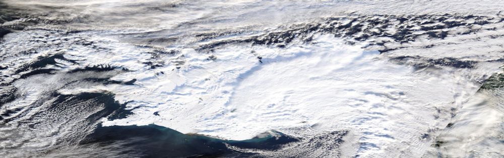
October 30, 2025 at 10:15 AM
Iceland is really living up to it's name currently.
Following on from record breaking heat earlier this year, Iceland has recorded record breaking amounts of snow for the time of year, Reykjavík for example has recorded 40CM of snowfall.
Iceland bucking the current very warm Arctic trend.
Following on from record breaking heat earlier this year, Iceland has recorded record breaking amounts of snow for the time of year, Reykjavík for example has recorded 40CM of snowfall.
Iceland bucking the current very warm Arctic trend.
On the left, the first ever hurricane captured by satellite category 5 Hurricane Esther in 1961 to today with this image of category 5 Hurricane Mellisa.
We have come a very, very long way in the last 64 years.
We have come a very, very long way in the last 64 years.


October 28, 2025 at 9:57 PM
On the left, the first ever hurricane captured by satellite category 5 Hurricane Esther in 1961 to today with this image of category 5 Hurricane Mellisa.
We have come a very, very long way in the last 64 years.
We have come a very, very long way in the last 64 years.
Hurricane Melissa is a record breaker.
210kt gust recorded above the surface setting a new world record, previous was 209kts by Typhoon Megi (2010)
The eye is now down to -5.21 making it the driest eye in Atlantic basin history, the world record is -5.00.
What a beast.
210kt gust recorded above the surface setting a new world record, previous was 209kts by Typhoon Megi (2010)
The eye is now down to -5.21 making it the driest eye in Atlantic basin history, the world record is -5.00.
What a beast.

October 27, 2025 at 4:10 PM
Hurricane Melissa is a record breaker.
210kt gust recorded above the surface setting a new world record, previous was 209kts by Typhoon Megi (2010)
The eye is now down to -5.21 making it the driest eye in Atlantic basin history, the world record is -5.00.
What a beast.
210kt gust recorded above the surface setting a new world record, previous was 209kts by Typhoon Megi (2010)
The eye is now down to -5.21 making it the driest eye in Atlantic basin history, the world record is -5.00.
What a beast.
Key takeaway from my early winter thoughts this year for the UK.
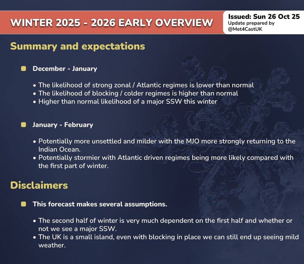
October 27, 2025 at 11:13 AM
Key takeaway from my early winter thoughts this year for the UK.