


The Weather Centre of Manitoba
@mbweathercentre.bsky.social
Manitoba Weather Updates and Weather Documentation!
Operating year round.
Founded by Lead Weather Forecaster:
Justin Oertel.
Based out of Brandon and Winnipeg Manitoba.
Join us on Facebook:
http://www.facebook.com/MBWeatherCentre
Operating year round.
Founded by Lead Weather Forecaster:
Justin Oertel.
Based out of Brandon and Winnipeg Manitoba.
Join us on Facebook:
http://www.facebook.com/MBWeatherCentre
Pinned


MEET THE TEAM:
Justin Oertel: Founder and Lead Weather Forecaster + Storm Chaser
Rachel Oertel: SM Moderator
Andrew Hamm: Storm Chaser + Weather Specialist
Jamie Freeman: Storm Chaser + Weather Specialist
Mike McGregor: Weather Specialist
Rae Oertel: SM Moderator + Weather Enthusiast
#weather
Justin Oertel: Founder and Lead Weather Forecaster + Storm Chaser
Rachel Oertel: SM Moderator
Andrew Hamm: Storm Chaser + Weather Specialist
Jamie Freeman: Storm Chaser + Weather Specialist
Mike McGregor: Weather Specialist
Rae Oertel: SM Moderator + Weather Enthusiast
#weather
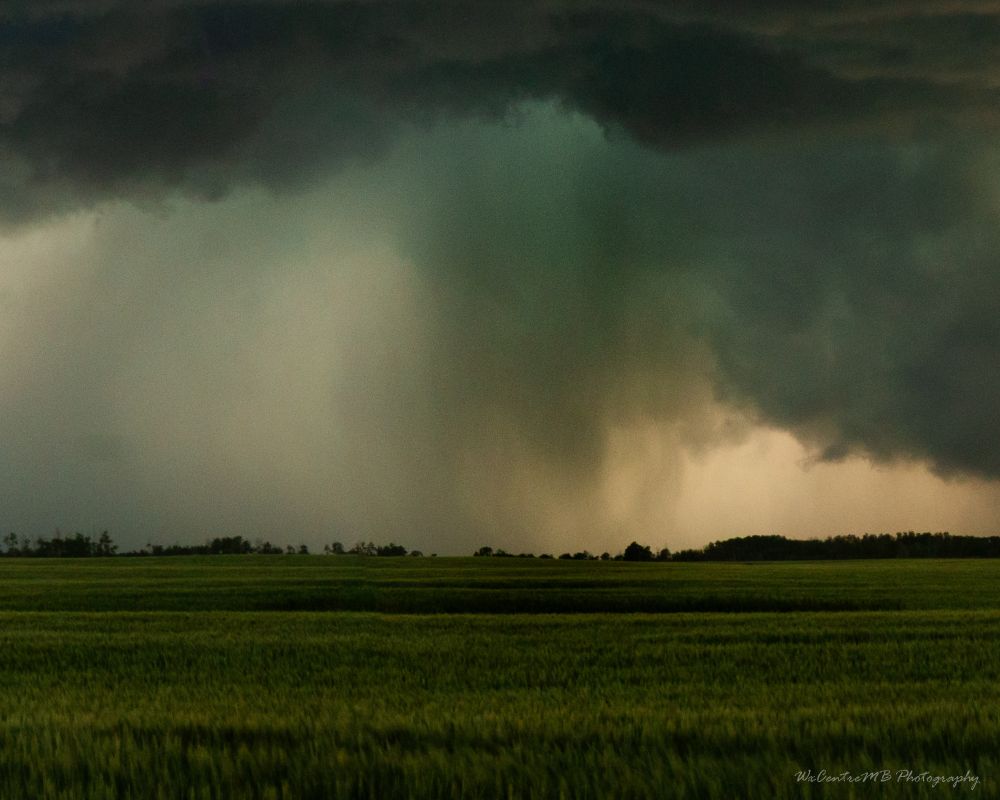
I am reviewing my photos from the July 3rd Storm Chase across far SE SK/SW MB and I came across this photo where it looks like a large funnel or tornado could have touched down briefly. Photo was taken at 8:52pm NE of Tilston, MB looking Westward
#SKStorm #MBStorm @ntp-reports.bsky.social
-Justin
#SKStorm #MBStorm @ntp-reports.bsky.social
-Justin


July 16, 2025 at 10:20 PM
I am reviewing my photos from the July 3rd Storm Chase across far SE SK/SW MB and I came across this photo where it looks like a large funnel or tornado could have touched down briefly. Photo was taken at 8:52pm NE of Tilston, MB looking Westward
#SKStorm #MBStorm @ntp-reports.bsky.social
-Justin
#SKStorm #MBStorm @ntp-reports.bsky.social
-Justin
Reposted by The Weather Centre of Manitoba

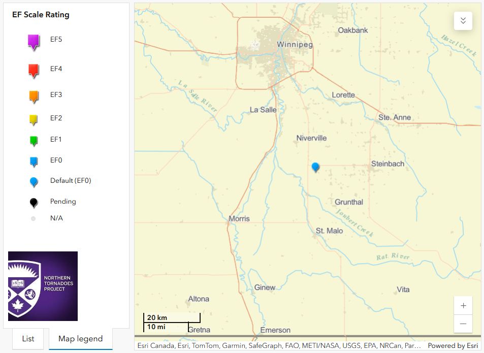
The NTP has confirmed a tornado near Sperling in southern Manitoba, southwest of Winnipeg, from the late-day storms on May 15. No damage was reported. Full details on this tornado (and results from other tornado reports investigated) here: uwo.ca/ntp/blog/202... #MBstorm

May 17, 2025 at 1:56 AM
The NTP has confirmed a tornado near Sperling in southern Manitoba, southwest of Winnipeg, from the late-day storms on May 15. No damage was reported. Full details on this tornado (and results from other tornado reports investigated) here: uwo.ca/ntp/blog/202... #MBstorm
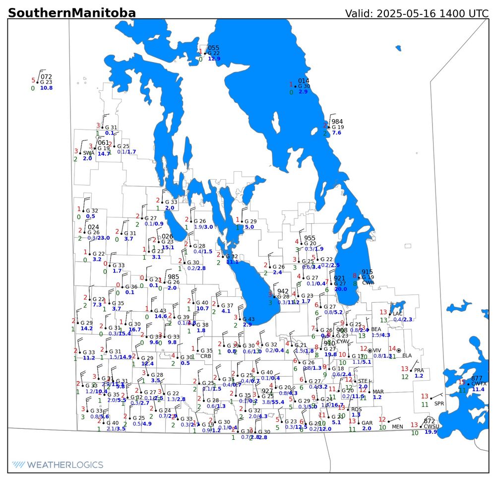
📰 ‼️ **BREAKING** ‼️ 📰
Two tornadoes have officially been CONFIRMED yesterday across Southeastern Manitoba. The first occurring near Sperling, Manitoba and then a second one occurring near Niverville.
That brings Manitoba’s total for tornadoes so far this year to 3! 🌪️
#mbwx #mbstorm
-Justin. 🤓
Two tornadoes have officially been CONFIRMED yesterday across Southeastern Manitoba. The first occurring near Sperling, Manitoba and then a second one occurring near Niverville.
That brings Manitoba’s total for tornadoes so far this year to 3! 🌪️
#mbwx #mbstorm
-Justin. 🤓

May 16, 2025 at 10:45 PM
Reposted by The Weather Centre of Manitoba

Southern Manitoba's wild week of weather continues. We started the week with the earliest 100 F (37.8 C) temperature reading in Canadian history. This morning, we have temperatures near 0 C in western Manitoba and perhaps even the odd flake of snow!
May 16, 2025 at 2:47 PM
Southern Manitoba's wild week of weather continues. We started the week with the earliest 100 F (37.8 C) temperature reading in Canadian history. This morning, we have temperatures near 0 C in western Manitoba and perhaps even the odd flake of snow!
Reposted by The Weather Centre of Manitoba
We’ve received several reports of tornadoes with the storms in southern Manitoba yesterday evening.
We are following up. A storm damage survey may be required, but to this point no damage has been reported.
Please send any reports to @ntp-reports.bsky.social or submit info at uwo.ca/ntp. #MBstorm
We are following up. A storm damage survey may be required, but to this point no damage has been reported.
Please send any reports to @ntp-reports.bsky.social or submit info at uwo.ca/ntp. #MBstorm
May 16, 2025 at 1:21 PM
We’ve received several reports of tornadoes with the storms in southern Manitoba yesterday evening.
We are following up. A storm damage survey may be required, but to this point no damage has been reported.
Please send any reports to @ntp-reports.bsky.social or submit info at uwo.ca/ntp. #MBstorm
We are following up. A storm damage survey may be required, but to this point no damage has been reported.
Please send any reports to @ntp-reports.bsky.social or submit info at uwo.ca/ntp. #MBstorm


Reposted by The Weather Centre of Manitoba

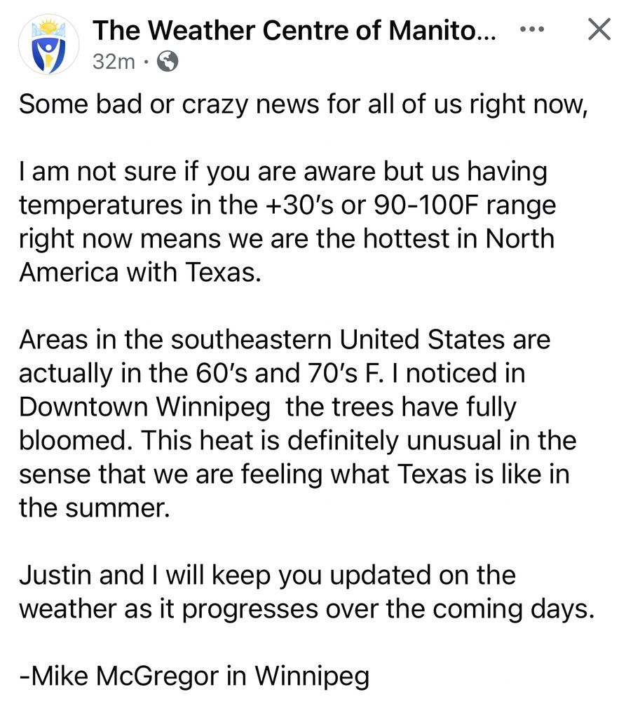
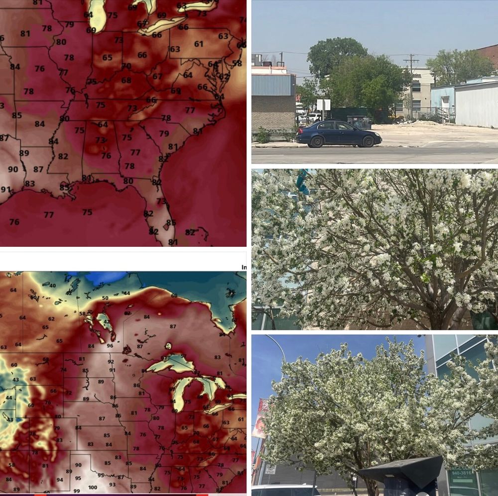
It’s so unusual hot, like really HOT…
But back to usual May long weekend weather with potential snow, because it’s a May Long tradition to have crappy weather!
We honestly need some substantial precipitation to help with the fire situation.
Happy Victory Day weekend!
@mbweathercentre.bsky.social
But back to usual May long weekend weather with potential snow, because it’s a May Long tradition to have crappy weather!
We honestly need some substantial precipitation to help with the fire situation.
Happy Victory Day weekend!
@mbweathercentre.bsky.social
May 13, 2025 at 6:56 PM
It’s so unusual hot, like really HOT…
But back to usual May long weekend weather with potential snow, because it’s a May Long tradition to have crappy weather!
We honestly need some substantial precipitation to help with the fire situation.
Happy Victory Day weekend!
@mbweathercentre.bsky.social
But back to usual May long weekend weather with potential snow, because it’s a May Long tradition to have crappy weather!
We honestly need some substantial precipitation to help with the fire situation.
Happy Victory Day weekend!
@mbweathercentre.bsky.social
Satellite Imagery from SE MB right now.
Circled in orange is a current area of interest.
It looks like thunderstorms may be forming from the fires burning NE of Bird River.. Either that, or the fires are escalating and smoke is shooting up 10k-20kft.
Impressive.. but not in a good way!
-Justin. 🤓
Circled in orange is a current area of interest.
It looks like thunderstorms may be forming from the fires burning NE of Bird River.. Either that, or the fires are escalating and smoke is shooting up 10k-20kft.
Impressive.. but not in a good way!
-Justin. 🤓

May 13, 2025 at 6:56 PM
Satellite Imagery from SE MB right now.
Circled in orange is a current area of interest.
It looks like thunderstorms may be forming from the fires burning NE of Bird River.. Either that, or the fires are escalating and smoke is shooting up 10k-20kft.
Impressive.. but not in a good way!
-Justin. 🤓
Circled in orange is a current area of interest.
It looks like thunderstorms may be forming from the fires burning NE of Bird River.. Either that, or the fires are escalating and smoke is shooting up 10k-20kft.
Impressive.. but not in a good way!
-Justin. 🤓
The City of Winnipeg has overtaken Carman for the Provincial and Canadian “Hot Spot” at 1:00pm with a temperature of +35 °C!! 😳 🥵 🥵
#mbwx #manitoba #winnipeg #weather #temperature
-Justin. 🤓
#mbwx #manitoba #winnipeg #weather #temperature
-Justin. 🤓

May 13, 2025 at 6:12 PM
The City of Winnipeg has overtaken Carman for the Provincial and Canadian “Hot Spot” at 1:00pm with a temperature of +35 °C!! 😳 🥵 🥵
#mbwx #manitoba #winnipeg #weather #temperature
-Justin. 🤓
#mbwx #manitoba #winnipeg #weather #temperature
-Justin. 🤓
‼️ 🚨 ***MAJOR BREAKING NEWS*** 🚨 ‼️
Nopiming, Manigotagan River, South Atikaki, and Wallace Lake Provincial Parks are all CLOSED to the Public UNTIL FURTHER NOTICE....
Please SHARE!!
#MBFire #Manitoba #ManitobaParks #Wildfire #StaySafe
-Justin. 🤓
Nopiming, Manigotagan River, South Atikaki, and Wallace Lake Provincial Parks are all CLOSED to the Public UNTIL FURTHER NOTICE....
Please SHARE!!
#MBFire #Manitoba #ManitobaParks #Wildfire #StaySafe
-Justin. 🤓

May 13, 2025 at 5:07 PM
‼️ 🚨 ***MAJOR BREAKING NEWS*** 🚨 ‼️
Nopiming, Manigotagan River, South Atikaki, and Wallace Lake Provincial Parks are all CLOSED to the Public UNTIL FURTHER NOTICE....
Please SHARE!!
#MBFire #Manitoba #ManitobaParks #Wildfire #StaySafe
-Justin. 🤓
Nopiming, Manigotagan River, South Atikaki, and Wallace Lake Provincial Parks are all CLOSED to the Public UNTIL FURTHER NOTICE....
Please SHARE!!
#MBFire #Manitoba #ManitobaParks #Wildfire #StaySafe
-Justin. 🤓
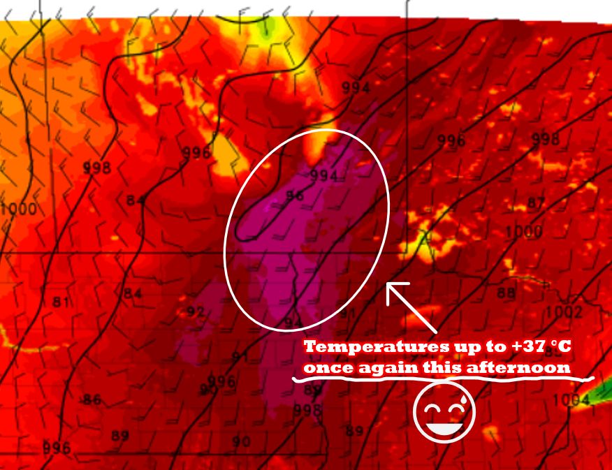
It's another SCORCHING HOT day out there, specifically for our friends down across the RRV and Southeastern Manitoba.
Temperatures will once again be nearing highs of up to +37 °C this afternoon for the area circled in white on the map!
#mbwx #mbstorm #mbheat #weather #manitoba
-Justin. 🤓
Temperatures will once again be nearing highs of up to +37 °C this afternoon for the area circled in white on the map!
#mbwx #mbstorm #mbheat #weather #manitoba
-Justin. 🤓
May 13, 2025 at 4:33 PM
Good Morning, everyone.
The daylight reveals on the Satellite Imagery that wildfires continue to burn out of control this morning and with breezy conditions today and more extreme heat, these fires could get worse before they get better later this week.
#mbwx #mbstorm #mbfire #manitoba
-Justin. 🤓
The daylight reveals on the Satellite Imagery that wildfires continue to burn out of control this morning and with breezy conditions today and more extreme heat, these fires could get worse before they get better later this week.
#mbwx #mbstorm #mbfire #manitoba
-Justin. 🤓

May 13, 2025 at 2:12 PM
CASFW + CASWL ⬇️ again…
This is a concerning trend we’ve been seeing. These radars aren’t that old to be acting this way. These are relatively new systems.
The Canadian Weather Radar Replacement Program began in 2017.
The project was completed by 2023,
with all 33 new radars installed.
-Justin. 🤓
This is a concerning trend we’ve been seeing. These radars aren’t that old to be acting this way. These are relatively new systems.
The Canadian Weather Radar Replacement Program began in 2017.
The project was completed by 2023,
with all 33 new radars installed.
-Justin. 🤓

May 13, 2025 at 12:39 PM
CASFW + CASWL ⬇️ again…
This is a concerning trend we’ve been seeing. These radars aren’t that old to be acting this way. These are relatively new systems.
The Canadian Weather Radar Replacement Program began in 2017.
The project was completed by 2023,
with all 33 new radars installed.
-Justin. 🤓
This is a concerning trend we’ve been seeing. These radars aren’t that old to be acting this way. These are relatively new systems.
The Canadian Weather Radar Replacement Program began in 2017.
The project was completed by 2023,
with all 33 new radars installed.
-Justin. 🤓
Reposted by The Weather Centre of Manitoba
Winnipeg has set a new daily record high for May 12. As of 3 PM, the temperature had reached 34.1°C, surpassing the previous record of 32.8°C set in 1958. There's another chance to break a record tomorrow—the May 13 record stands at 33.3°C, set in 1900.
May 12, 2025 at 8:33 PM
Winnipeg has set a new daily record high for May 12. As of 3 PM, the temperature had reached 34.1°C, surpassing the previous record of 32.8°C set in 1958. There's another chance to break a record tomorrow—the May 13 record stands at 33.3°C, set in 1900.
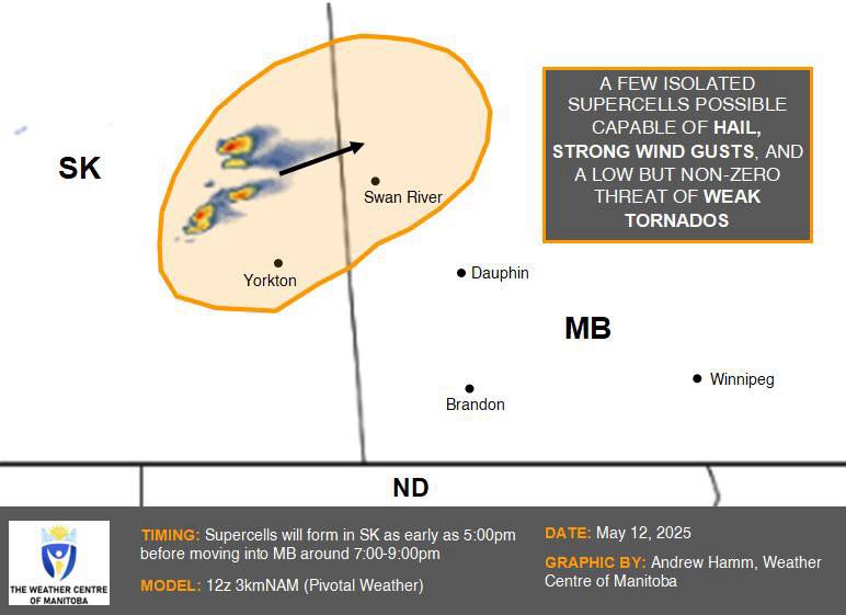
SEVERE WEATHER POTENTIAL THIS AFTERNOON/EVENING
A couple isolated supercells are likely to form in far eastern SK in the late afternoon, passing into the greater Swan River area later in the evening.
Although the threat appears to be quite low, a weak tornado or two cannot be ruled out.
-Andrew 🌪️
A couple isolated supercells are likely to form in far eastern SK in the late afternoon, passing into the greater Swan River area later in the evening.
Although the threat appears to be quite low, a weak tornado or two cannot be ruled out.
-Andrew 🌪️
May 12, 2025 at 6:45 PM
SEVERE WEATHER POTENTIAL THIS AFTERNOON/EVENING
A couple isolated supercells are likely to form in far eastern SK in the late afternoon, passing into the greater Swan River area later in the evening.
Although the threat appears to be quite low, a weak tornado or two cannot be ruled out.
-Andrew 🌪️
A couple isolated supercells are likely to form in far eastern SK in the late afternoon, passing into the greater Swan River area later in the evening.
Although the threat appears to be quite low, a weak tornado or two cannot be ruled out.
-Andrew 🌪️

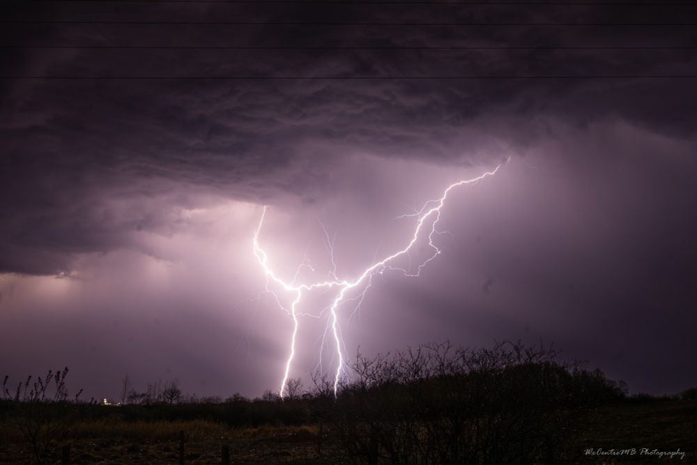
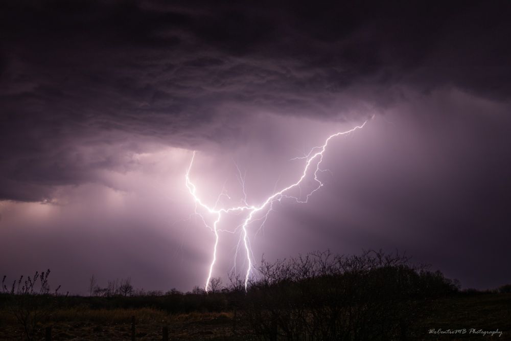
Good Morning, everyone.
Here are my Lightning photos I shot last night around 10:00pm just Southeast of Brandon as a line of non-severe thunderstorms moved through the area.
It was nice to get out and enjoy the first, of hopefully many, chases this Season!
-Justin. 🤓
#mbwx #mbstorm #manitoba
Here are my Lightning photos I shot last night around 10:00pm just Southeast of Brandon as a line of non-severe thunderstorms moved through the area.
It was nice to get out and enjoy the first, of hopefully many, chases this Season!
-Justin. 🤓
#mbwx #mbstorm #manitoba


May 6, 2025 at 12:01 PM
WOW!!! It’s a BEAUTIFUL DAY today!!
Get out and enjoy it! ☀️ 🥵
-Justin. 🤓
#mbwx #manitoba #beautifulday #hot #weather #bdnmb #enjoyit #bbqseason
Get out and enjoy it! ☀️ 🥵
-Justin. 🤓
#mbwx #manitoba #beautifulday #hot #weather #bdnmb #enjoyit #bbqseason
May 4, 2025 at 7:57 PM
WOW!!! It’s a BEAUTIFUL DAY today!!
Get out and enjoy it! ☀️ 🥵
-Justin. 🤓
#mbwx #manitoba #beautifulday #hot #weather #bdnmb #enjoyit #bbqseason
Get out and enjoy it! ☀️ 🥵
-Justin. 🤓
#mbwx #manitoba #beautifulday #hot #weather #bdnmb #enjoyit #bbqseason
Reposted by The Weather Centre of Manitoba
The NTP has confirmed a weak landspout-type tornado that occurred in southern Manitoba yesterday. Thanks to those that shared photos, video and eyewitness accounts.
Details at the NTP blog here:
uwo.ca/ntp/blog/202...
#MBstorm
Details at the NTP blog here:
uwo.ca/ntp/blog/202...
#MBstorm
May 1, 2025 at 9:18 PM
The NTP has confirmed a weak landspout-type tornado that occurred in southern Manitoba yesterday. Thanks to those that shared photos, video and eyewitness accounts.
Details at the NTP blog here:
uwo.ca/ntp/blog/202...
#MBstorm
Details at the NTP blog here:
uwo.ca/ntp/blog/202...
#MBstorm
Good Afternoon, everyone. 👋
Western and Southwestern Manitoba stands a chance for a couple of THUNDERSTORMS this afternoon into the early evening hours. ⛈️
The area circled has the best chance for a few storms.
-Justin. 🤓
#mbwx #manitoba #hrrr #weather #storm #thunderstorms #bdnmb #update
Western and Southwestern Manitoba stands a chance for a couple of THUNDERSTORMS this afternoon into the early evening hours. ⛈️
The area circled has the best chance for a few storms.
-Justin. 🤓
#mbwx #manitoba #hrrr #weather #storm #thunderstorms #bdnmb #update

May 1, 2025 at 5:23 PM
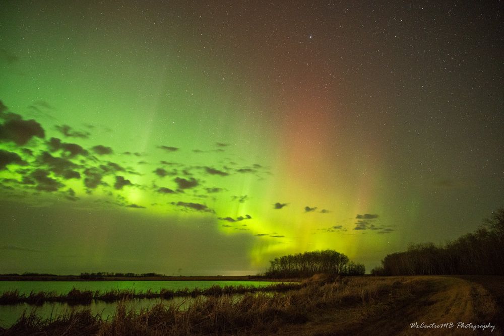
The Northern Lights made a swift appearance last night North of Brandon as a fast, yet potent solar wind enhancement impacted our planet.
-Justin. 🤓
#mbwx #manitoba #northernlights #solarweather #photography #nikon #bdnmb #spring
-Justin. 🤓
#mbwx #manitoba #northernlights #solarweather #photography #nikon #bdnmb #spring


May 1, 2025 at 4:31 PM
The Northern Lights made a swift appearance last night North of Brandon as a fast, yet potent solar wind enhancement impacted our planet.
-Justin. 🤓
#mbwx #manitoba #northernlights #solarweather #photography #nikon #bdnmb #spring
-Justin. 🤓
#mbwx #manitoba #northernlights #solarweather #photography #nikon #bdnmb #spring