


Instant Weather
@instantweather.bsky.social
Canada’s independent and community-driven weather organization. Providing context to severe weather since 2013. Visit our website: instantweather.ca
#ONStorm #ONwx ☃️ KEEP YOUR SHOVELS READY: Yet More Snow on the Way for Southern Ontario With a Snowy System on Sunday Bringing Up to 10-20cm
📅 Saturday, November 29 - Sunday, November 30, 2025
⤵️ VIEW THE FULL FORECAST:
instantweatherinc.com/article/onta...
- Brennen
📅 Saturday, November 29 - Sunday, November 30, 2025
⤵️ VIEW THE FULL FORECAST:
instantweatherinc.com/article/onta...
- Brennen

Yet More Snow on the Way for Southern Ontario With a Snowy System on Sunday Bringing Up to 10-20cm
As many communities in the snowbelt regions around Lake Huron and Georgian Bay are currently digging out from locally over 50cm of snow from squalls over the past two days, another snow maker is alrea...
instantweatherinc.com
November 29, 2025 at 7:48 AM
#ONStorm #ONwx ☃️ KEEP YOUR SHOVELS READY: Yet More Snow on the Way for Southern Ontario With a Snowy System on Sunday Bringing Up to 10-20cm
📅 Saturday, November 29 - Sunday, November 30, 2025
⤵️ VIEW THE FULL FORECAST:
instantweatherinc.com/article/onta...
- Brennen
📅 Saturday, November 29 - Sunday, November 30, 2025
⤵️ VIEW THE FULL FORECAST:
instantweatherinc.com/article/onta...
- Brennen
#ONStorm #ONwx 🚌 ‘Snow Day’ Forecast: Widespread School Bus Cancellations Expected in Southern Ontario’s Snowbelt on Friday
📅 Friday, November 28, 2025
⤵️ VIEW TOMORROW'S FORECAST HERE ⤵️
🔗 instantweatherinc.com/article/onta...
- Brennen
📅 Friday, November 28, 2025
⤵️ VIEW TOMORROW'S FORECAST HERE ⤵️
🔗 instantweatherinc.com/article/onta...
- Brennen
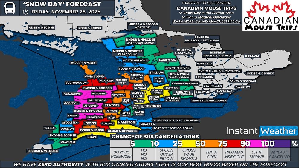
‘Snow Day’ Forecast: Widespread School Bus Cancellations Expected in Southern Ontario’s Snowbelt on Friday
Use Promo Code ‘ Instant ’ to Receive a Min. $25 Gift Card With Your Vacation!
instantweatherinc.com
November 28, 2025 at 12:33 AM
#ONStorm #ONwx 🚌 ‘Snow Day’ Forecast: Widespread School Bus Cancellations Expected in Southern Ontario’s Snowbelt on Friday
📅 Friday, November 28, 2025
⤵️ VIEW TOMORROW'S FORECAST HERE ⤵️
🔗 instantweatherinc.com/article/onta...
- Brennen
📅 Friday, November 28, 2025
⤵️ VIEW TOMORROW'S FORECAST HERE ⤵️
🔗 instantweatherinc.com/article/onta...
- Brennen
#ONStorm #ONwx 🚌 ‘Snow Day’ Forecast: Intense Snow Squall Risk Could Cancel School Buses in Parts of Southern Ontario on Thursday
📅 Thursday, November 27, 2025
⤵️ VIEW TOMORROW'S FORECAST HERE ⤵️
🔗 instantweatherinc.com/article/onta...
- Brennen
📅 Thursday, November 27, 2025
⤵️ VIEW TOMORROW'S FORECAST HERE ⤵️
🔗 instantweatherinc.com/article/onta...
- Brennen

‘Snow Day’ Forecast: Intense Snow Squall Risk Could Cancel School Buses in Parts of Southern Ontario on Thursday
Snow squalls are expected to affect areas around Lake Huron and Georgian Bay throughout the day on Thursday. Environment Canada has issued widespread snow squall watches and warnings for the regions m...
instantweatherinc.com
November 27, 2025 at 3:02 AM
#ONStorm #ONwx 🚌 ‘Snow Day’ Forecast: Intense Snow Squall Risk Could Cancel School Buses in Parts of Southern Ontario on Thursday
📅 Thursday, November 27, 2025
⤵️ VIEW TOMORROW'S FORECAST HERE ⤵️
🔗 instantweatherinc.com/article/onta...
- Brennen
📅 Thursday, November 27, 2025
⤵️ VIEW TOMORROW'S FORECAST HERE ⤵️
🔗 instantweatherinc.com/article/onta...
- Brennen
#ONStorm #ONwx ❄️ Dangerous Snow Squalls Target Southern Ontario’s Snowbelt Starting Thursday With Up to 75cm of Snow Possible
📅 Thursday, November 27 - Friday, November 28, 2025
⤵️ VIEW THE FULL FORECAST:
instantweatherinc.com/article/onta...
- Brennen
📅 Thursday, November 27 - Friday, November 28, 2025
⤵️ VIEW THE FULL FORECAST:
instantweatherinc.com/article/onta...
- Brennen

Dangerous Snow Squalls Target Southern Ontario’s Snowbelt Starting Thursday With Up to 75cm of Snow Possible
Confidence continues to grow in what is shaping up to be a potentially dangerous snow squall event for regions east of Lake Huron and southeast of Georgian Bay as we wrap up the week. Temperatures ar...
instantweatherinc.com
November 27, 2025 at 1:17 AM
#ONStorm #ONwx ❄️ Dangerous Snow Squalls Target Southern Ontario’s Snowbelt Starting Thursday With Up to 75cm of Snow Possible
📅 Thursday, November 27 - Friday, November 28, 2025
⤵️ VIEW THE FULL FORECAST:
instantweatherinc.com/article/onta...
- Brennen
📅 Thursday, November 27 - Friday, November 28, 2025
⤵️ VIEW THE FULL FORECAST:
instantweatherinc.com/article/onta...
- Brennen
⚠️ IMPORTANT: A ‘Yellow Warning - Snow’ is different from a ‘Yellow Snow Warning’.
- Adam
- Adam

November 27, 2025 at 12:21 AM
⚠️ IMPORTANT: A ‘Yellow Warning - Snow’ is different from a ‘Yellow Snow Warning’.
- Adam
- Adam
⚠️ BIG CHANGES to Environment Canada’s Alerts Beginning Today
Details: instantweatherinc.com/article/canada/2025/11/26/big-changes-to-environment-canadas-alerts
- Adam & Brennen
Details: instantweatherinc.com/article/canada/2025/11/26/big-changes-to-environment-canadas-alerts
- Adam & Brennen

⚠️ BIG CHANGES to Environment Canada’s Alerts Beginning Today
Environment Canada is making big changes to the way it issues weather alerts, in an attempt to make them easier to understand at a glance. Starting today, Wednesday, November 26th, 2025, the new syst...
instantweatherinc.com
November 26, 2025 at 6:31 PM
⚠️ BIG CHANGES to Environment Canada’s Alerts Beginning Today
Details: instantweatherinc.com/article/canada/2025/11/26/big-changes-to-environment-canadas-alerts
- Adam & Brennen
Details: instantweatherinc.com/article/canada/2025/11/26/big-changes-to-environment-canadas-alerts
- Adam & Brennen
#ONStorm #ONwx ‼️❄️ Winter Storm Targets Northern Ontario This Week as Intense Snow Squalls Line Up for Southern Ontario Starting Thursday
📅 Tuesday, November 25 - Friday, November 28, 2025
⤵️ VIEW THE FULL FORECAST:
instantweatherinc.com/article/onta...
- Brennen
📅 Tuesday, November 25 - Friday, November 28, 2025
⤵️ VIEW THE FULL FORECAST:
instantweatherinc.com/article/onta...
- Brennen

Winter Storm Targets Northern Ontario This Week as Intense Snow Squalls Line Up for Southern Ontario Starting Thursday
A powerful system will sweep through the Great Lakes region this week, bringing a major winter storm to Northern Ontario and setting the stage for a significant snow squall event across Southern Ontar...
instantweatherinc.com
November 25, 2025 at 7:37 AM
#ONStorm #ONwx ‼️❄️ Winter Storm Targets Northern Ontario This Week as Intense Snow Squalls Line Up for Southern Ontario Starting Thursday
📅 Tuesday, November 25 - Friday, November 28, 2025
⤵️ VIEW THE FULL FORECAST:
instantweatherinc.com/article/onta...
- Brennen
📅 Tuesday, November 25 - Friday, November 28, 2025
⤵️ VIEW THE FULL FORECAST:
instantweatherinc.com/article/onta...
- Brennen

#ONStorm #ONwx Rare November Stratospheric Warming Event Could Spread Arctic Chill Across Canada for December 🥶
instantweatherinc.com/article/cana...
- Alannah
instantweatherinc.com/article/cana...
- Alannah

Rare November Stratospheric Warming Event Could Spread Arctic Chill Across Canada for December
You may have heard a new term being thrown around in the news and on social media: “Sudden Stratospheric Warming”. It’s not a new term, meteorologically speaking, and it’s related to the polar vortex....
instantweatherinc.com
November 20, 2025 at 8:02 PM
#ONStorm #ONwx Rare November Stratospheric Warming Event Could Spread Arctic Chill Across Canada for December 🥶
instantweatherinc.com/article/cana...
- Alannah
instantweatherinc.com/article/cana...
- Alannah
#ONStorm #ONwx ☃️ GET YOUR SHOVEL: Snow Squalls Take Aim at London, Barrie and Northern GTA on Sunday With Up to 25-50cm of Snow Possible
📅 Sunday, November 16 - Monday, November 17, 2025
⤵️ VIEW THE FULL FORECAST:
instantweatherinc.com/article/onta...
- Brennen
📅 Sunday, November 16 - Monday, November 17, 2025
⤵️ VIEW THE FULL FORECAST:
instantweatherinc.com/article/onta...
- Brennen

Snow Squalls Take Aim at London, Barrie and Northern GTA on Sunday With Up to 25-50cm of Snow Possible
We enjoyed a brief break from the wintry weather on Saturday as temperatures soared into the double digits across much of Southern Ontario. The exception was Eastern Ontario, where the Ottawa Valley d...
instantweatherinc.com
November 16, 2025 at 3:37 AM
#ONStorm #ONwx ☃️ GET YOUR SHOVEL: Snow Squalls Take Aim at London, Barrie and Northern GTA on Sunday With Up to 25-50cm of Snow Possible
📅 Sunday, November 16 - Monday, November 17, 2025
⤵️ VIEW THE FULL FORECAST:
instantweatherinc.com/article/onta...
- Brennen
📅 Sunday, November 16 - Monday, November 17, 2025
⤵️ VIEW THE FULL FORECAST:
instantweatherinc.com/article/onta...
- Brennen
#ONStorm #ONwx ⚡️🧊All the Seasons in One Weekend for Southern Ontario as Freezing Rain, Thunderstorms and Snow Squalls Line Up
📅 Saturday, November 15 - Sunday, November 16, 2025
⤵️ VIEW THE FULL FORECAST:
instantweatherinc.com/article/onta...
- Brennen
📅 Saturday, November 15 - Sunday, November 16, 2025
⤵️ VIEW THE FULL FORECAST:
instantweatherinc.com/article/onta...
- Brennen

All the Seasons in One Weekend for Southern Ontario as Freezing Rain, Thunderstorms and Snow Squalls Line Up
There is really only one way to describe what November has been like across Southern Ontario when it comes to the weather: a roller coaster. Last weekend brought our first widespread snowfall event o...
instantweatherinc.com
November 15, 2025 at 5:12 AM
#ONStorm #ONwx ⚡️🧊All the Seasons in One Weekend for Southern Ontario as Freezing Rain, Thunderstorms and Snow Squalls Line Up
📅 Saturday, November 15 - Sunday, November 16, 2025
⤵️ VIEW THE FULL FORECAST:
instantweatherinc.com/article/onta...
- Brennen
📅 Saturday, November 15 - Sunday, November 16, 2025
⤵️ VIEW THE FULL FORECAST:
instantweatherinc.com/article/onta...
- Brennen
Reposted by Instant Weather
The NTP has confirmed 11 new ON tornadoes based on AI-assisted satellite review. All caused EF1-EF2 tree damage.
These are in addition to 5 tornadoes already confirmed in ON via AI-assisted satellite review. All sectors in Ontario have now been reviewed.
Details: uwo.ca/ntp/blog/202...
#ONstorm
These are in addition to 5 tornadoes already confirmed in ON via AI-assisted satellite review. All sectors in Ontario have now been reviewed.
Details: uwo.ca/ntp/blog/202...
#ONstorm

November 12, 2025 at 3:46 PM
The NTP has confirmed 11 new ON tornadoes based on AI-assisted satellite review. All caused EF1-EF2 tree damage.
These are in addition to 5 tornadoes already confirmed in ON via AI-assisted satellite review. All sectors in Ontario have now been reviewed.
Details: uwo.ca/ntp/blog/202...
#ONstorm
These are in addition to 5 tornadoes already confirmed in ON via AI-assisted satellite review. All sectors in Ontario have now been reviewed.
Details: uwo.ca/ntp/blog/202...
#ONstorm


Girthy Canadian polar shaft penetrates deep into the US today into Monday. 🥶
The polar shaft is normally a lot larger but it’s quite cold out and shrinkage is having a big influence.
- Adam & Brennen
The polar shaft is normally a lot larger but it’s quite cold out and shrinkage is having a big influence.
- Adam & Brennen

November 9, 2025 at 8:53 AM
Girthy Canadian polar shaft penetrates deep into the US today into Monday. 🥶
The polar shaft is normally a lot larger but it’s quite cold out and shrinkage is having a big influence.
- Adam & Brennen
The polar shaft is normally a lot larger but it’s quite cold out and shrinkage is having a big influence.
- Adam & Brennen
#ONStorm #ONwx 😫❄️ Southern Ontario to Plunge Into Winter as Sunday Snowstorm Could Dump Up to 20 cm of Snow
📅 Saturday, November 8 - Monday, November 10, 2025
⤵️ VIEW THE FULL FORECAST:
instantweatherinc.com/article/onta...
- Brennen
📅 Saturday, November 8 - Monday, November 10, 2025
⤵️ VIEW THE FULL FORECAST:
instantweatherinc.com/article/onta...
- Brennen

Southern Ontario to Plunge Into Winter as Sunday Snowstorm Could Dump Up to 20 cm of Snow
It feels like just yesterday we were talking about record-breaking heat that stretched well into October. But November has been a completely different story, with winter now making its presence known ...
instantweatherinc.com
November 7, 2025 at 1:28 AM
#ONStorm #ONwx 😫❄️ Southern Ontario to Plunge Into Winter as Sunday Snowstorm Could Dump Up to 20 cm of Snow
📅 Saturday, November 8 - Monday, November 10, 2025
⤵️ VIEW THE FULL FORECAST:
instantweatherinc.com/article/onta...
- Brennen
📅 Saturday, November 8 - Monday, November 10, 2025
⤵️ VIEW THE FULL FORECAST:
instantweatherinc.com/article/onta...
- Brennen
⚠️ ZOMBIE OUTBREAK REPORTED 🧟♂️
Based on your amazing reports from across the country, we can now confirm we’re in the middle of a significant Canada-wide Zombie Outbreak!
We do have to wait for the official rating from the Northern Zombie Project (NZP) but based on your reports…
1/2…
Based on your amazing reports from across the country, we can now confirm we’re in the middle of a significant Canada-wide Zombie Outbreak!
We do have to wait for the official rating from the Northern Zombie Project (NZP) but based on your reports…
1/2…

November 1, 2025 at 2:52 AM
⚠️ ZOMBIE OUTBREAK REPORTED 🧟♂️
Based on your amazing reports from across the country, we can now confirm we’re in the middle of a significant Canada-wide Zombie Outbreak!
We do have to wait for the official rating from the Northern Zombie Project (NZP) but based on your reports…
1/2…
Based on your amazing reports from across the country, we can now confirm we’re in the middle of a significant Canada-wide Zombie Outbreak!
We do have to wait for the official rating from the Northern Zombie Project (NZP) but based on your reports…
1/2…
ZOMBIE WATCH ISSUED by Zombie & Creeper Containment Canada (ZCCC):
Please be on high alert for Zombies this evening across Canada. There is also a slight chance of ghouls, witches, creatures and random pop-culture icons.
1/5…
Please be on high alert for Zombies this evening across Canada. There is also a slight chance of ghouls, witches, creatures and random pop-culture icons.
1/5…

October 31, 2025 at 6:41 PM
ZOMBIE WATCH ISSUED by Zombie & Creeper Containment Canada (ZCCC):
Please be on high alert for Zombies this evening across Canada. There is also a slight chance of ghouls, witches, creatures and random pop-culture icons.
1/5…
Please be on high alert for Zombies this evening across Canada. There is also a slight chance of ghouls, witches, creatures and random pop-culture icons.
1/5…
The clouds in #Barrie are really cooking this morning! 👀 What are you experiencing? This is a timelapse because regular video didn’t do it justice. Some lake-effect s… rain this morning for some of us. Won’t be too long until we’ve got lake effect s… Never mind, I can’t even say it. 🤐
#onstorm
#onstorm
October 20, 2025 at 12:05 PM
⚠️ Flooding Risk forecast has been expanded by Environment Canada for 50-100mm of rainfall 💦 possible and 70km/h wind gusts 💨 today, Wed, Sept 24, 2025 in the 🟡 yellow (A) region located in parts of Southwestern Ontario, Central Ontario & western GTHA.
- Adam
#onstorm #ontario #ontarioweather
- Adam
#onstorm #ontario #ontarioweather

September 24, 2025 at 3:20 PM
⚠️ Flooding Risk forecast has been expanded by Environment Canada for 50-100mm of rainfall 💦 possible and 70km/h wind gusts 💨 today, Wed, Sept 24, 2025 in the 🟡 yellow (A) region located in parts of Southwestern Ontario, Central Ontario & western GTHA.
- Adam
#onstorm #ontario #ontarioweather
- Adam
#onstorm #ontario #ontarioweather


Huge thanks to Samantha, Clare & Duane from The Globe & Mail for featuring InstantWeather in an article about severe weather anxiety. 🤗
You can pick up the traditional print version tomorrow and here’s a paywall-free link to the digital version:
www.theglobeandmail.com/gift/3b8af88...
You can pick up the traditional print version tomorrow and here’s a paywall-free link to the digital version:
www.theglobeandmail.com/gift/3b8af88...

August 1, 2025 at 5:01 PM
Huge thanks to Samantha, Clare & Duane from The Globe & Mail for featuring InstantWeather in an article about severe weather anxiety. 🤗
You can pick up the traditional print version tomorrow and here’s a paywall-free link to the digital version:
www.theglobeandmail.com/gift/3b8af88...
You can pick up the traditional print version tomorrow and here’s a paywall-free link to the digital version:
www.theglobeandmail.com/gift/3b8af88...

#onstorm BREAKING: ⚠️ Tornado risk 🌪 mentioned by Environment Canada for southwestern Ontario, Wed overnight into Thurs morning & for eastern Ontario Thurs afternoon into the early evening hours in their latest severe weather outlook. They also mention 90km/h wind gusts & 30-50mm of rainfall.

July 17, 2025 at 12:22 AM
#onstorm BREAKING: ⚠️ Tornado risk 🌪 mentioned by Environment Canada for southwestern Ontario, Wed overnight into Thurs morning & for eastern Ontario Thurs afternoon into the early evening hours in their latest severe weather outlook. They also mention 90km/h wind gusts & 30-50mm of rainfall.
