


helenmakesmaps
@helenmakesmaps.bsky.social
Cartographer, data visualizer, beans on toast defender.
helenmakesmaps.com for tutorials
helenmakesmaps.com for tutorials
What does AI mean for entry-level employment in geo? How can we benefit from the tech of today without limiting the talent of tomorrow?
Thoughts and ideas for graduates, employers & educators from someone totally unqualified to have them (me) 👇
www.helenmakesmaps.com/post/what-do...
Thoughts and ideas for graduates, employers & educators from someone totally unqualified to have them (me) 👇
www.helenmakesmaps.com/post/what-do...

What does AI mean for entry-level employment in geospatial?
Discover how AI is reshaping entry-level employment in geospatial. Learn about AI's impact and future opportunities in the geospatial field.
www.helenmakesmaps.com
May 1, 2025 at 11:27 AM
What does AI mean for entry-level employment in geo? How can we benefit from the tech of today without limiting the talent of tomorrow?
Thoughts and ideas for graduates, employers & educators from someone totally unqualified to have them (me) 👇
www.helenmakesmaps.com/post/what-do...
Thoughts and ideas for graduates, employers & educators from someone totally unqualified to have them (me) 👇
www.helenmakesmaps.com/post/what-do...
10/10 recommend for lovers of geography & pubs, the perfect combo! 🌎🍻

April 1, 2025 at 7:20 AM
10/10 recommend for lovers of geography & pubs, the perfect combo! 🌎🍻
🗻 Where can you see Mt. Fuji from?
Check out my tutorial for creating these types of visualisations here: helenmakesmaps.com/post/how-to-...
#GIS #geospatial
Check out my tutorial for creating these types of visualisations here: helenmakesmaps.com/post/how-to-...
#GIS #geospatial

March 28, 2025 at 10:33 AM
🗻 Where can you see Mt. Fuji from?
Check out my tutorial for creating these types of visualisations here: helenmakesmaps.com/post/how-to-...
#GIS #geospatial
Check out my tutorial for creating these types of visualisations here: helenmakesmaps.com/post/how-to-...
#GIS #geospatial
I made both of these maps today 😁


March 20, 2025 at 7:24 PM
I made both of these maps today 😁
My content de-gating continues - and here's my latest piece: How to run visibility analysis in QGIS!
🔥 Run visibility analysis with free tools
💸 Find awesome, high res data
🌍 Turn this into epic visualizations
www.helenmakesmaps.com/post/how-to-...
🔥 Run visibility analysis with free tools
💸 Find awesome, high res data
🌍 Turn this into epic visualizations
www.helenmakesmaps.com/post/how-to-...

How to run visibility analysis in QGIS
Learn how to run + visualise visibility analysis in QGIS!
www.helenmakesmaps.com
March 14, 2025 at 4:27 PM
My content de-gating continues - and here's my latest piece: How to run visibility analysis in QGIS!
🔥 Run visibility analysis with free tools
💸 Find awesome, high res data
🌍 Turn this into epic visualizations
www.helenmakesmaps.com/post/how-to-...
🔥 Run visibility analysis with free tools
💸 Find awesome, high res data
🌍 Turn this into epic visualizations
www.helenmakesmaps.com/post/how-to-...
🚕🗽 NYC taxi trips
Pink areas = more pickups
Blue areas = more dropoffs
Explore the interactive version 👉 clausa.app.carto.com/map/c79de176...
Pink areas = more pickups
Blue areas = more dropoffs
Explore the interactive version 👉 clausa.app.carto.com/map/c79de176...


March 9, 2025 at 9:21 AM
🚕🗽 NYC taxi trips
Pink areas = more pickups
Blue areas = more dropoffs
Explore the interactive version 👉 clausa.app.carto.com/map/c79de176...
Pink areas = more pickups
Blue areas = more dropoffs
Explore the interactive version 👉 clausa.app.carto.com/map/c79de176...
Raster has just landed on the cloud and it is MASSIVE! ☁️
One of my favourite parts of my job is I get to play with - I mean, "test and quality assure" - these things, and here are some of my favourite raster experiments in CARTO so far!
More stuff 👉 carto.com/blog/unlock-...
One of my favourite parts of my job is I get to play with - I mean, "test and quality assure" - these things, and here are some of my favourite raster experiments in CARTO so far!
More stuff 👉 carto.com/blog/unlock-...

February 27, 2025 at 4:40 PM
Raster has just landed on the cloud and it is MASSIVE! ☁️
One of my favourite parts of my job is I get to play with - I mean, "test and quality assure" - these things, and here are some of my favourite raster experiments in CARTO so far!
More stuff 👉 carto.com/blog/unlock-...
One of my favourite parts of my job is I get to play with - I mean, "test and quality assure" - these things, and here are some of my favourite raster experiments in CARTO so far!
More stuff 👉 carto.com/blog/unlock-...
Sometimes I look at my AI prompts and wonder if I even think any more
February 18, 2025 at 5:32 PM
Sometimes I look at my AI prompts and wonder if I even think any more
Guess I just won't map US flood risk today then. Wild that this data is just... Gone?
February 14, 2025 at 8:18 PM
Guess I just won't map US flood risk today then. Wild that this data is just... Gone?
I don't want to see a pie chart that shows % of my life trying to guess whether a date field in some data is formatted for US or everyone else.
February 7, 2025 at 11:55 AM
I don't want to see a pie chart that shows % of my life trying to guess whether a date field in some data is formatted for US or everyone else.
Mega excited for the Geospatial Risk Summit next week in NYC! 🗽 🇺🇸
I'll be running a "Scaling climate risk analysis with CARTO" technical workshop where we'll be doing this low-code analysis 👇 and making this map 👇 to use real-time weather alerts to stay up-to-date on potential claims.
I'll be running a "Scaling climate risk analysis with CARTO" technical workshop where we'll be doing this low-code analysis 👇 and making this map 👇 to use real-time weather alerts to stay up-to-date on potential claims.
January 23, 2025 at 11:28 AM
Mega excited for the Geospatial Risk Summit next week in NYC! 🗽 🇺🇸
I'll be running a "Scaling climate risk analysis with CARTO" technical workshop where we'll be doing this low-code analysis 👇 and making this map 👇 to use real-time weather alerts to stay up-to-date on potential claims.
I'll be running a "Scaling climate risk analysis with CARTO" technical workshop where we'll be doing this low-code analysis 👇 and making this map 👇 to use real-time weather alerts to stay up-to-date on potential claims.
After making a massive $7.19 in 4 months (less than the $10 payout threshold), I've decided to start ungating my Medium-hosted tutorials (it's not really in the knowledge-sharing spirit anyway!) and migrate them to my website, starting with... www.helenmakesmaps.com/post/how-to-... 🎆🗺️
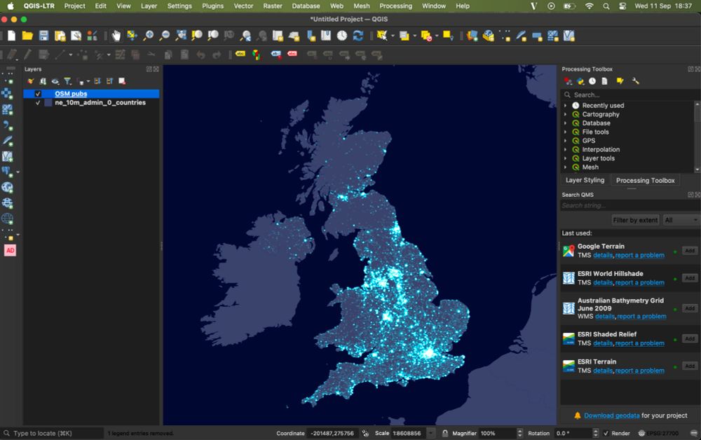
How to make a firefly map with QGIS
Follow this quick and easy guide to create stunning firefly maps with QGIS! 🌟
www.helenmakesmaps.com
January 17, 2025 at 11:10 AM
After making a massive $7.19 in 4 months (less than the $10 payout threshold), I've decided to start ungating my Medium-hosted tutorials (it's not really in the knowledge-sharing spirit anyway!) and migrate them to my website, starting with... www.helenmakesmaps.com/post/how-to-... 🎆🗺️
Hi I'm Helen and I don't know how Bluesky works! I'll be sharing maps & dataviz that I make and love - as well as tutorials on how to recreate them!
These will likely be interspersed with photos of my enormous cat and/or lunch.
These will likely be interspersed with photos of my enormous cat and/or lunch.

January 15, 2025 at 10:42 AM
Hi I'm Helen and I don't know how Bluesky works! I'll be sharing maps & dataviz that I make and love - as well as tutorials on how to recreate them!
These will likely be interspersed with photos of my enormous cat and/or lunch.
These will likely be interspersed with photos of my enormous cat and/or lunch.