

Tao Huang
@geospatialtao.bsky.social
Boise State University researcher interested in remote sensing, hydrology, and machine learning.
Reposted by Tao Huang

![Comic. The Most-Observed Animal and Plant in Each State on iNaturalist. (Not the most common species in the state, just the one people have reported the most times.) [labeled map of the US] WA: Mallard/Western Sword Fern. OR: Mule Deer/Western Ponderosa Pine. CA: Western Fence Lizard/California Poppy. HI: Green Sea Turtle/‘Ōhi’a Lehua. ID: Mallard/Big Sagebrush. NV: Common Side-Blotched Lizard/Creosote Bush. MT: White-Tailed Deer/Common Yarrow. WY: American Bison/Sticky Geranium. UT: Mule Deer/Utah Juniper. AZ: Ornate Tree Lizard/Saguaro. CO: Mule Deer/Great Mullein. NM: Mule Deer/Creosote Bush. AK: Moose/Fireweed. ND: American Bison/Prairie Rose. SD: American Bison/Hoary Vervain. NE: American Robin/Common Milkweed. KS: Ornate Box Turtle/Amur Honeysuckle. OK: Pond Slider/Eastern Redcedar. TX: Northern Cardinal/Pinladies. MN, WI, IL: Common Eastern Bumble Bee/Common Milkweed. IA, MI: White-Tailed Deer/Common Milkweed. MO: Brown-Belted Bumble Bee/Amur Honeysuckle. AR: Three-toed Box Turtle/Chinese Privet. LA: Green Anole/Baldcypress. IN: American Robin/Amur Honeysuckle. OH: Eastern Pondhawk/Virginia Springbeauty. KY: Common Box Turtle/Amur Honeysuckle. TN: American Robin/Christmas Fern. MS: Northern Cardinal/Pale Pitcher Plant. AL: Gulf Fritillary/American Sweetgum. GA: Green Anole/American Sweetgum. FL: Brown Anole/White Beggarticks. NY: Eastern Gray Squirrel/White Snakeroot. PA: White-Tailed Deer/Garlic Mustard. WV: White-Tailed Deer/Great Rhododendron. VA: White-Tailed Deer/Eastern Poison Ivy. MD: White-Tailed Deer/Wineberry. DE: Fowler’s Toad/American Pokeweed. NC: Eastern Gray Squirrel/Christmas Fern. SC: Northern Cardinal/American Sweetgum. NJ: Spotted Lanternfly/Common Mugwort. VT: Common Eastern Bumble Bee/Eastern White Pine. NH: White-Tailed Deer/Eastern White Pine. MA: Common Eastern Bumble Bee/Eastern White Pine. CT: Common Eastern Bumble Bee/Striped Wintergreen. RI: American Herring Gull. ME: American Herring Gull/Canadian Bunchberry.](https://cdn.bsky.app/img/feed_thumbnail/plain/did:plc:cz73r7iyiqn26upot4jtjdhk/bafkreic4f56ywseq7bqc7zza3y76pxyzn5c5htebrior6jdbrfszhuiquy@jpeg)
July 22, 2025 at 7:52 PM
Reposted by Tao Huang

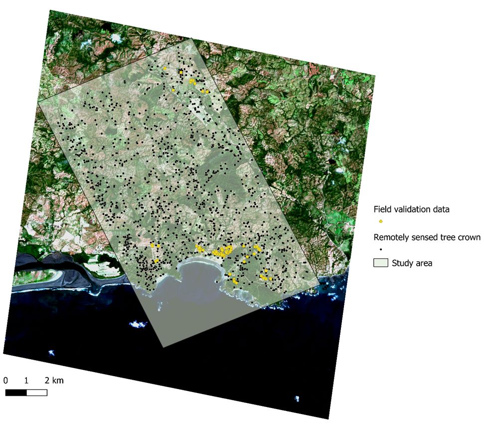
🚨 New paper, led by Cristina Barber. We used high-resolution aerial imagery to study tree mortality in a tropical landscape. Large, isolated trees were most likely to die--alarming finding! @ecologicalsociety.bsky.social esajournals.onlinelibrary.wiley.com/doi/10.1002/...
June 11, 2025 at 9:49 PM
🚨 New paper, led by Cristina Barber. We used high-resolution aerial imagery to study tree mortality in a tropical landscape. Large, isolated trees were most likely to die--alarming finding! @ecologicalsociety.bsky.social esajournals.onlinelibrary.wiley.com/doi/10.1002/...
Reposted by Tao Huang

🚀 The GeoAI Python package just added a new building regularization method. 🎉
Check it out:
📝 Notebook: geoai.gishub.org/examples/reg...
📂 GitHub: github.com/opengeos/geoai
Give it a try! 🌍✨
#geoai #python #building
Check it out:
📝 Notebook: geoai.gishub.org/examples/reg...
📂 GitHub: github.com/opengeos/geoai
Give it a try! 🌍✨
#geoai #python #building
April 10, 2025 at 3:56 PM
🚀 The GeoAI Python package just added a new building regularization method. 🎉
Check it out:
📝 Notebook: geoai.gishub.org/examples/reg...
📂 GitHub: github.com/opengeos/geoai
Give it a try! 🌍✨
#geoai #python #building
Check it out:
📝 Notebook: geoai.gishub.org/examples/reg...
📂 GitHub: github.com/opengeos/geoai
Give it a try! 🌍✨
#geoai #python #building
Thank you! We're exploring a similar approach comparing UAS and satellite imagery in a post-fire environment here in Idaho. We're particularly interested in investigating the consequences of hillslope runoff and erosion.
Hydrology Paper of the Day @geospatialtao.bsky.social on a novel framework for UAS remote sensing of rangelands: the Reynolds Creek Experimental Watershed in southwest Idaho; machine learning image classification; comparison with existing data products; and the effects of spatial resolution.
Our paper shows how high-resolution multispectral drone imagery can effectively map vegetation cover in spatially heterogeneous landscapes: link.springer.com/article/10.1...
May 6, 2025 at 6:21 PM
Thank you! We're exploring a similar approach comparing UAS and satellite imagery in a post-fire environment here in Idaho. We're particularly interested in investigating the consequences of hillslope runoff and erosion.
Nature fuels creativity

Nature and creativity – the science of "soft fascination" and how time outdoors resets the brain www.themarginalian.org/2022/07/01/d...

Nature and Creativity: The Science of “Soft Fascination” and How the Natural World Resets the Brain
“Our everyday experience does not prepare us to assimilate the gaping hugeness of the Grand Canyon or the crashing grandeur of Niagara Falls. We have no response at the ready; our usual frame…
www.themarginalian.org
April 21, 2025 at 4:53 AM
Nature fuels creativity
Our paper shows how high-resolution multispectral drone imagery can effectively map vegetation cover in spatially heterogeneous landscapes: link.springer.com/article/10.1...
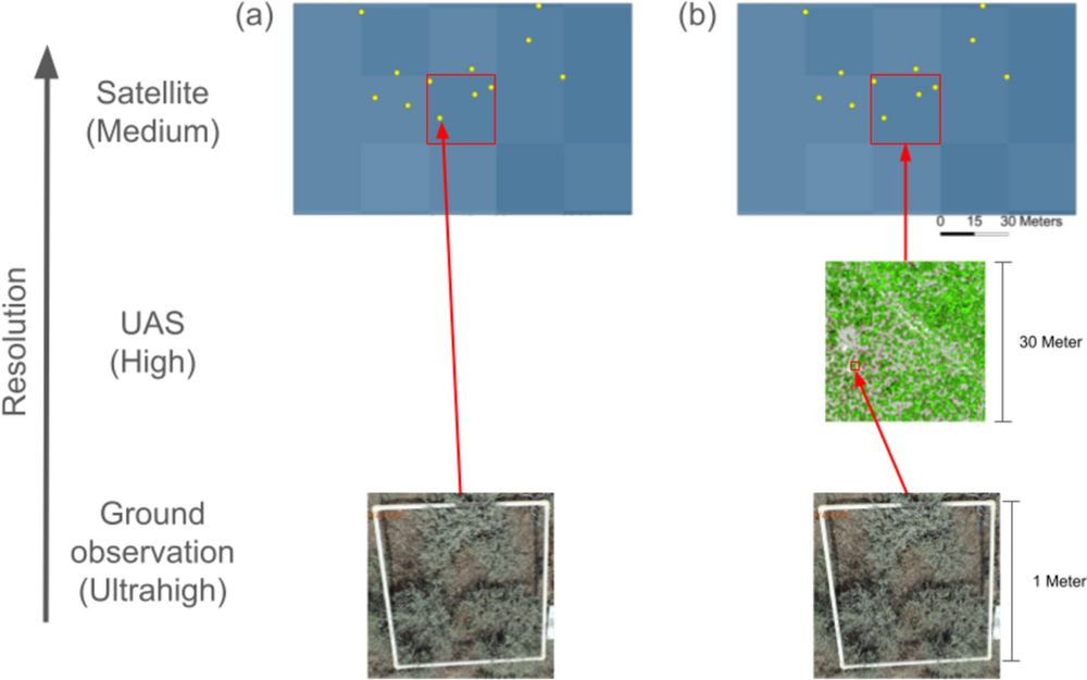
Quantifying rangeland fractional cover in the Northern Great Basin sagebrush steppe communities using high-resolution unoccupied aerial systems (UAS) imagery - Landscape Ecology
Context Satellite products of fractional vegetation cover are often used to manage rangelands. However, they frequently miss the details of heterogeneous landscapes. The use of unoccupied aerial syste...
link.springer.com
January 14, 2025 at 10:38 PM
Our paper shows how high-resolution multispectral drone imagery can effectively map vegetation cover in spatially heterogeneous landscapes: link.springer.com/article/10.1...