


Emma
@emmamabraham.bsky.social
Congressional Staffer | #UW Alum #GoDawgs | #Mariners & #Kraken fan | #Space & #Weather nerd #wawx | Girl & husk(ies) mom | Posts are mine, etc.
Pinned


Reposted by Emma
Same story for Washington (pictured) and Oregon.
Need 90th percentile snow from here on out to get to normal.
No snow coming anytime soon, so we'd need a record snowy Feb-Mar just to reach normal.
Hint: that ain't happening.
Need 90th percentile snow from here on out to get to normal.
No snow coming anytime soon, so we'd need a record snowy Feb-Mar just to reach normal.
Hint: that ain't happening.

January 13, 2026 at 7:44 PM
Same story for Washington (pictured) and Oregon.
Need 90th percentile snow from here on out to get to normal.
No snow coming anytime soon, so we'd need a record snowy Feb-Mar just to reach normal.
Hint: that ain't happening.
Need 90th percentile snow from here on out to get to normal.
No snow coming anytime soon, so we'd need a record snowy Feb-Mar just to reach normal.
Hint: that ain't happening.
Reposted by Emma
One of those days in Seattle where you should probably cancel your afternoon meetings and take an extended lunch because it might be a while before we have sunshine and nearly 60 degree temperatures again.
(by the way, the record high for the date is 58)
(by the way, the record high for the date is 58)
January 13, 2026 at 6:37 PM
One of those days in Seattle where you should probably cancel your afternoon meetings and take an extended lunch because it might be a while before we have sunshine and nearly 60 degree temperatures again.
(by the way, the record high for the date is 58)
(by the way, the record high for the date is 58)
Reposted by Emma
What month is it...you may ask...as temperatures reach the upper 50s (even isolated low 60s) today across Western Washington! Enjoy it, because by tomorrow morning, it's going to be quite foggy, dense fog in some spots, with widespread visibility under 1/4 mile. Stay tuned! #wawx


January 13, 2026 at 6:04 PM
What month is it...you may ask...as temperatures reach the upper 50s (even isolated low 60s) today across Western Washington! Enjoy it, because by tomorrow morning, it's going to be quite foggy, dense fog in some spots, with widespread visibility under 1/4 mile. Stay tuned! #wawx
Reposted by Emma
No YouTube briefings as I've been sick, but here's the latest W. WA update:
An atmospheric river is impacting the region thru Monday, with 1-2" rain for the lowlands & 3-5" for mtns/coast. Sharp cutoff on the south side of the precip, plus high snow levels. #wawx
An atmospheric river is impacting the region thru Monday, with 1-2" rain for the lowlands & 3-5" for mtns/coast. Sharp cutoff on the south side of the precip, plus high snow levels. #wawx


January 11, 2026 at 7:58 AM
No YouTube briefings as I've been sick, but here's the latest W. WA update:
An atmospheric river is impacting the region thru Monday, with 1-2" rain for the lowlands & 3-5" for mtns/coast. Sharp cutoff on the south side of the precip, plus high snow levels. #wawx
An atmospheric river is impacting the region thru Monday, with 1-2" rain for the lowlands & 3-5" for mtns/coast. Sharp cutoff on the south side of the precip, plus high snow levels. #wawx
Reposted by Emma
Heads up folks! We’ve got some heavy rain moving into the Puget Sound area tonight! Take it slow on the roads!! (7:30 PM Saturday) #wawx

January 11, 2026 at 3:34 AM
Heads up folks! We’ve got some heavy rain moving into the Puget Sound area tonight! Take it slow on the roads!! (7:30 PM Saturday) #wawx
Reposted by Emma
🚨 ACTIVE WEATHER AHEAD!!
➡️ SNOW: Major mountain snow, 2-4 feet in Cascades by Thursday, major travel impacts possible
➡️ RAIN: 0.75-2" across W. WA thru Thurs.
➡️ WIND: Gusts 35-45 mph Tuesday morn.
➡️ WAVES: Large swells Wed/Thur, plus area-wide coastal flooding
#wawx
➡️ SNOW: Major mountain snow, 2-4 feet in Cascades by Thursday, major travel impacts possible
➡️ RAIN: 0.75-2" across W. WA thru Thurs.
➡️ WIND: Gusts 35-45 mph Tuesday morn.
➡️ WAVES: Large swells Wed/Thur, plus area-wide coastal flooding
#wawx


January 6, 2026 at 6:43 AM
🚨 ACTIVE WEATHER AHEAD!!
➡️ SNOW: Major mountain snow, 2-4 feet in Cascades by Thursday, major travel impacts possible
➡️ RAIN: 0.75-2" across W. WA thru Thurs.
➡️ WIND: Gusts 35-45 mph Tuesday morn.
➡️ WAVES: Large swells Wed/Thur, plus area-wide coastal flooding
#wawx
➡️ SNOW: Major mountain snow, 2-4 feet in Cascades by Thursday, major travel impacts possible
➡️ RAIN: 0.75-2" across W. WA thru Thurs.
➡️ WIND: Gusts 35-45 mph Tuesday morn.
➡️ WAVES: Large swells Wed/Thur, plus area-wide coastal flooding
#wawx
Reposted by Emma

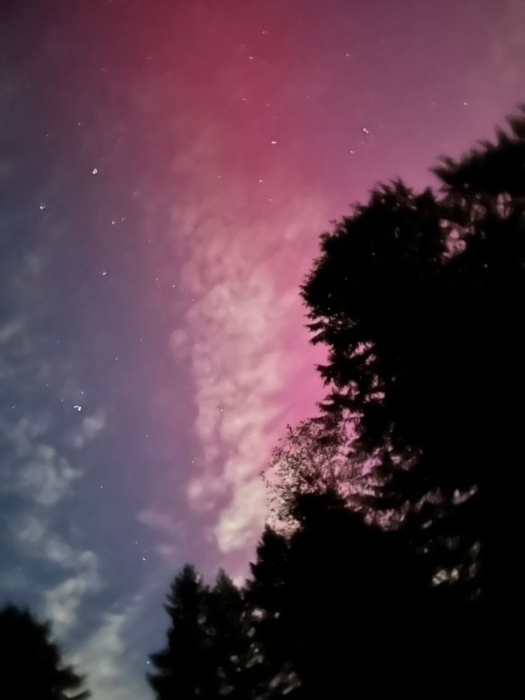
Lots of color out there this morning....
January 4, 2026 at 7:21 PM
Lots of color out there this morning....
Reposted by Emma

Happy New Year from the Washington coast. Wishing all of us courage, community and joy in the year ahead. As they say: We are going to win.
January 2, 2026 at 1:11 AM
Happy New Year from the Washington coast. Wishing all of us courage, community and joy in the year ahead. As they say: We are going to win.
Reposted by Emma
Just checked with the experts and the Space Needle has not disappeared. It really is still there.
Happy New Year!
(Yes. We said the same thing in 2024)
Happy New Year!
(Yes. We said the same thing in 2024)

January 1, 2026 at 8:13 AM
Just checked with the experts and the Space Needle has not disappeared. It really is still there.
Happy New Year!
(Yes. We said the same thing in 2024)
Happy New Year!
(Yes. We said the same thing in 2024)
Reposted by Emma
FINAL UPDATE OF 2025!!
Visibility reported at 0.13 miles at Boeing Field & air quality is getting worse across the metro, with light winds & smoke. As we see on the KOMO News Columbia Tower cam, #Seattle is encased in a low layer of fog. An interesting fireworks show ahead! #wawx
Visibility reported at 0.13 miles at Boeing Field & air quality is getting worse across the metro, with light winds & smoke. As we see on the KOMO News Columbia Tower cam, #Seattle is encased in a low layer of fog. An interesting fireworks show ahead! #wawx


January 1, 2026 at 7:42 AM

Reposted by Emma
The Space Needle is in there somewhere

January 1, 2026 at 5:03 AM
The Space Needle is in there somewhere
Reposted by Emma
Amazing drone view of the North Head Lighthouse on Tuesday (filmed outside state/national park boundaries), with the Columbia River and Oregon’s Coast Range in the background! #wawx #pnw #lighthouse #drone

December 31, 2025 at 1:46 AM
Amazing drone view of the North Head Lighthouse on Tuesday (filmed outside state/national park boundaries), with the Columbia River and Oregon’s Coast Range in the background! #wawx #pnw #lighthouse #drone
Reposted by Emma
After a crazy December, there's not much PNW weather news to report.
A few weak weather systems will move through from Thursday night -> next week. Temperatures will be near-normal and precipitation will generally be light.
For mid-January, current odds favor a transition back to dry weather.
A few weak weather systems will move through from Thursday night -> next week. Temperatures will be near-normal and precipitation will generally be light.
For mid-January, current odds favor a transition back to dry weather.
December 30, 2025 at 10:53 PM
After a crazy December, there's not much PNW weather news to report.
A few weak weather systems will move through from Thursday night -> next week. Temperatures will be near-normal and precipitation will generally be light.
For mid-January, current odds favor a transition back to dry weather.
A few weak weather systems will move through from Thursday night -> next week. Temperatures will be near-normal and precipitation will generally be light.
For mid-January, current odds favor a transition back to dry weather.
Reposted by Emma
Cold morning w/lots of frost & areas of black ice across Western WA, with lows in the upper 20s to low 30s across the region, and down to the mid teens to low 20s in the mountains…and down to 0° in the Methow Valley! #wawx


December 28, 2025 at 5:34 PM
Cold morning w/lots of frost & areas of black ice across Western WA, with lows in the upper 20s to low 30s across the region, and down to the mid teens to low 20s in the mountains…and down to 0° in the Methow Valley! #wawx
Reposted by Emma
It took until the third-to-last morning of 2025 but we finally have just our second official frozen morning this winter in #Seattle.
emeraldcityweather.com/seattle-free... #wawx
emeraldcityweather.com/seattle-free... #wawx

‘Seattle Freeze’ returns as literal thing this week - Emerald City Weather Blog
It took until the third-to-last morning of 2025 but we finally have just our second official frozen morning
emeraldcityweather.com
December 28, 2025 at 5:57 PM
It took until the third-to-last morning of 2025 but we finally have just our second official frozen morning this winter in #Seattle.
emeraldcityweather.com/seattle-free... #wawx
emeraldcityweather.com/seattle-free... #wawx
Reposted by Emma
❄️❄️ Did you get some lowland snow overnight? Comment your photos, location, and amount, and I’ll feature your photos in today’s video on Western Washington Weather! #wawx
December 27, 2025 at 4:36 PM
❄️❄️ Did you get some lowland snow overnight? Comment your photos, location, and amount, and I’ll feature your photos in today’s video on Western Washington Weather! #wawx


Aaaaand it’s really picked up now. Approx. 1 inch of accumulation out here now - sounds like it’s much heavier in Sultan and Gold Bar. Classic convergence zone stuff! #wawx
December 27, 2025 at 2:54 AM
Aaaaand it’s really picked up now. Approx. 1 inch of accumulation out here now - sounds like it’s much heavier in Sultan and Gold Bar. Classic convergence zone stuff! #wawx


Reposted by Emma
Strong Convergence Zone band between Port Gamble and Stevens Pass bringing some reports of snow pellets or rain/snow mix in southern Snohomish County as of 3:45 PM! What are you seeing out there? #wawx

December 26, 2025 at 11:59 PM
Strong Convergence Zone band between Port Gamble and Stevens Pass bringing some reports of snow pellets or rain/snow mix in southern Snohomish County as of 3:45 PM! What are you seeing out there? #wawx
Reposted by Emma
12 PM Wed: Our low has tracked up the Coast Range and is near the Olympic Mountains now. It is very weak, with barely a pressure gradient at all behind it. That being said, winds are very minor. Expect gusts of 20-35 mph at most across the region thru this evening. #wawx


December 24, 2025 at 8:12 PM
12 PM Wed: Our low has tracked up the Coast Range and is near the Olympic Mountains now. It is very weak, with barely a pressure gradient at all behind it. That being said, winds are very minor. Expect gusts of 20-35 mph at most across the region thru this evening. #wawx
Reposted by Emma
The "wind storm" such as it is, is coming through the Seattle area now with gusts around 25-35 mph (though West Point off Magnolia hit 41 mph). Breezy weather will move north through the afternoon but no impacts expected.
December 24, 2025 at 10:42 PM
The "wind storm" such as it is, is coming through the Seattle area now with gusts around 25-35 mph (though West Point off Magnolia hit 41 mph). Breezy weather will move north through the afternoon but no impacts expected.
Reposted by Emma
5:50 AM Wed: Good news, folks! Surface obs show that our storm has moved inland over OR. This means that we will have weaker winds, likely gusting 40-45 mph for most areas Seattle south, and 45-55 mph Seattle north, strongest near water. 8 AM livestream canceled, video at 10 AM. #wawx


December 24, 2025 at 1:56 PM
5:50 AM Wed: Good news, folks! Surface obs show that our storm has moved inland over OR. This means that we will have weaker winds, likely gusting 40-45 mph for most areas Seattle south, and 45-55 mph Seattle north, strongest near water. 8 AM livestream canceled, video at 10 AM. #wawx
Reposted by Emma
5:50 AM Wed: Good news, folks! Surface obs show that our storm has moved inland over OR. This means that we will have weaker winds, likely gusting 40-45 mph for most areas Seattle south, and 45-55 mph Seattle north, strongest near water. 8 AM livestream canceled, video at 10 AM. #wawx
I will be LIVE at 8 AM to talk about the storm. For now, charge your devices and check out my late-night video.
Christmas Eve Windstorm: Late Night Update
#wawx
youtu.be/z51YeVO1G5A
Christmas Eve Windstorm: Late Night Update
#wawx
youtu.be/z51YeVO1G5A

Christmas Eve Windstorm: Late Night Update
YouTube video by Western Washington Weather
youtu.be
December 24, 2025 at 1:57 PM
5:50 AM Wed: Good news, folks! Surface obs show that our storm has moved inland over OR. This means that we will have weaker winds, likely gusting 40-45 mph for most areas Seattle south, and 45-55 mph Seattle north, strongest near water. 8 AM livestream canceled, video at 10 AM. #wawx