


Chris Crosby
@crosbycj.bsky.social
Co-Founder & PI @opentopography.org
Geodetic Imaging Data (#lidar, laser scanning, UAS, photogrammetry, InSAR) Program Manager at @earthscope.org
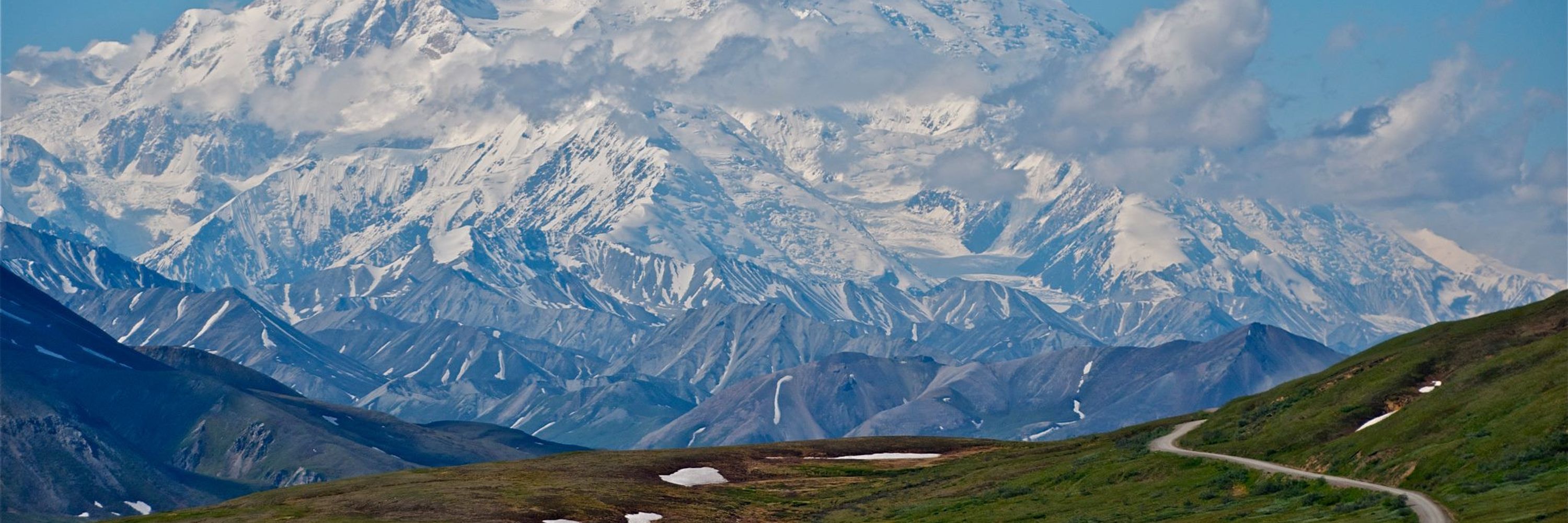
Bikes & skis in Crested Butte, CO.
Geodetic Imaging Data (#lidar, laser scanning, UAS, photogrammetry, InSAR) Program Manager at @earthscope.org
Bikes & skis in Crested Butte, CO.
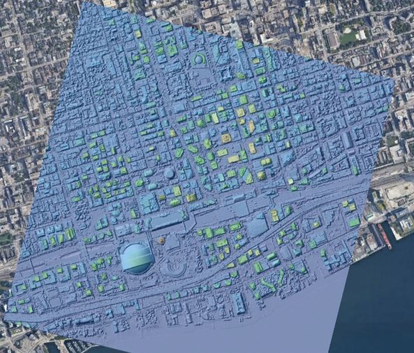
Topographic #lidar differencing by @opentopography.org team following the 2025 Los Angeles wildfires highlighted in @beautifulpublicdata.com & @technologyreview.com
Summary of original work:
opentopography.org/blog/using-l...
Summary of original work:
opentopography.org/blog/using-l...
August 27, 2025 at 4:40 PM
Topographic #lidar differencing by @opentopography.org team following the 2025 Los Angeles wildfires highlighted in @beautifulpublicdata.com & @technologyreview.com
Summary of original work:
opentopography.org/blog/using-l...
Summary of original work:
opentopography.org/blog/using-l...
Reposted by Chris Crosby
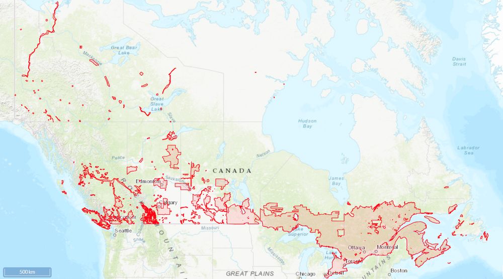
OpenTopography is excited to announce a major expansion to its international data catalog with the addition of the High Resolution Digital Elevation Model from Natural Resources Canada. This 1-meter resolution dataset is ideal for a wide range of applications.
opentopography.org/news/opentop...
opentopography.org/news/opentop...
July 23, 2025 at 2:35 PM
OpenTopography is excited to announce a major expansion to its international data catalog with the addition of the High Resolution Digital Elevation Model from Natural Resources Canada. This 1-meter resolution dataset is ideal for a wide range of applications.
opentopography.org/news/opentop...
opentopography.org/news/opentop...
Reposted by Chris Crosby
Neguse: Only in Washington, D.C. could politicians come to the floor and brag about cutting $9 billion from rural radio stations while two weeks ago they voted to increase the deficit by $4 trillion. Spare us these lectures.
July 18, 2025 at 2:58 AM
Neguse: Only in Washington, D.C. could politicians come to the floor and brag about cutting $9 billion from rural radio stations while two weeks ago they voted to increase the deficit by $4 trillion. Spare us these lectures.
Reposted by Chris Crosby
New topographic datasets are now available on OpenTopography! June additions include lidar over Mount Ruapehu (New Zealand), Point Beach State Forest (WI), and new NOAA coastal data from Florida and the Southeast U.S.
➡️ opentopography.org/news/june-20...
➡️ opentopography.org/news/june-20...


July 10, 2025 at 5:52 PM
New topographic datasets are now available on OpenTopography! June additions include lidar over Mount Ruapehu (New Zealand), Point Beach State Forest (WI), and new NOAA coastal data from Florida and the Southeast U.S.
➡️ opentopography.org/news/june-20...
➡️ opentopography.org/news/june-20...
Reposted by Chris Crosby
CALL YOUR SENATORS TODAY OR TOMORROW AND ASK THEM TO SAVE NSF!!! Full Committee Markup of NSF Appropriations for FY26 is happening Thursday morning at 9:30 EDT.
July 8, 2025 at 9:36 PM
CALL YOUR SENATORS TODAY OR TOMORROW AND ASK THEM TO SAVE NSF!!! Full Committee Markup of NSF Appropriations for FY26 is happening Thursday morning at 9:30 EDT.
Reposted by Chris Crosby

🧪 Detailed data viz NYT article, out today, on the extent of funding cuts at the National Science Foundation.
This "broken pie chart" is neat & new to me: Powerfully shows the slowdown in new NSF awards across areas.
www.nytimes.com/interactive/...
This "broken pie chart" is neat & new to me: Powerfully shows the slowdown in new NSF awards across areas.
www.nytimes.com/interactive/...
May 22, 2025 at 3:59 PM
🧪 Detailed data viz NYT article, out today, on the extent of funding cuts at the National Science Foundation.
This "broken pie chart" is neat & new to me: Powerfully shows the slowdown in new NSF awards across areas.
www.nytimes.com/interactive/...
This "broken pie chart" is neat & new to me: Powerfully shows the slowdown in new NSF awards across areas.
www.nytimes.com/interactive/...
Reposted by Chris Crosby
OpenTopography's April 2025 data releases include Land Information New Zealand (LINZ) coverage of Auckland, New Zealand, UAV lidar surveys in California, and SfM high resolution topography of Stromboli Volcano, Italy.
Discover the data here: opentopography.org/news/april-2...
Discover the data here: opentopography.org/news/april-2...


May 6, 2025 at 5:24 PM
OpenTopography's April 2025 data releases include Land Information New Zealand (LINZ) coverage of Auckland, New Zealand, UAV lidar surveys in California, and SfM high resolution topography of Stromboli Volcano, Italy.
Discover the data here: opentopography.org/news/april-2...
Discover the data here: opentopography.org/news/april-2...
Reposted by Chris Crosby
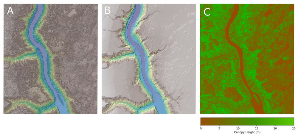
Check out the latest updates to RiverREM, a Python package that automatically generates river REM visualizations. Recent improvements include new colormap options (including custom and cmocean palettes), more efficient CPU and RAM usage, and expanded documentation.
buff.ly/bwtP8Vs
buff.ly/bwtP8Vs

April 9, 2025 at 4:30 PM
Check out the latest updates to RiverREM, a Python package that automatically generates river REM visualizations. Recent improvements include new colormap options (including custom and cmocean palettes), more efficient CPU and RAM usage, and expanded documentation.
buff.ly/bwtP8Vs
buff.ly/bwtP8Vs
Cassie Brigham and I will be teaching this @opentopography.org short course. Please join us if you are planning to be in Minnesota for the GAGE/SAGE workshop.
Planning on attending the 2025 NSF GAGE/SAGE Community Science Workshop? OpenTopography will be offering a short course, providing an introduction to OpenTopography, with a focus on tools for computing topographic change from multi-temporal data.
Learn More & Register: www.earthscope.org/workshop
Learn More & Register: www.earthscope.org/workshop

March 19, 2025 at 6:48 PM
Cassie Brigham and I will be teaching this @opentopography.org short course. Please join us if you are planning to be in Minnesota for the GAGE/SAGE workshop.
Reposted by Chris Crosby
Using #lidar to understand the impacts of the 2025 Palisades and Eaton Fires, Los Angeles, CA: We processed pre- & post- fire lidar data to illustrate the changes to the natural and built environments caused by these devastating fires. Blog for more info & images: opentopography.org/blog/using-l...


February 11, 2025 at 3:55 PM
Using #lidar to understand the impacts of the 2025 Palisades and Eaton Fires, Los Angeles, CA: We processed pre- & post- fire lidar data to illustrate the changes to the natural and built environments caused by these devastating fires. Blog for more info & images: opentopography.org/blog/using-l...
This is the 2nd time @opentopography.org has collaborated with the Yurok Tribe to make #lidar data available. The first was in 2020 with the publication of the “Klamath River Renewal” dataset: opentopography.org/news/klamath...
February 27, 2025 at 5:22 PM
This is the 2nd time @opentopography.org has collaborated with the Yurok Tribe to make #lidar data available. The first was in 2020 with the publication of the “Klamath River Renewal” dataset: opentopography.org/news/klamath...
Reposted by Chris Crosby
Join us for the FREE OpenTopography Spring Webinar Series. Four weekly hour-long webinars starting March 5th. We'll provide an overview of OpenTopography, high resolution topography (#lidar), and OpenTopography's processing tools. Registration & more information: opentopography.org/news/2025-we...

February 26, 2025 at 3:11 PM
Join us for the FREE OpenTopography Spring Webinar Series. Four weekly hour-long webinars starting March 5th. We'll provide an overview of OpenTopography, high resolution topography (#lidar), and OpenTopography's processing tools. Registration & more information: opentopography.org/news/2025-we...
Reposted by Chris Crosby
We've expanded and refreshed OpenTopography governance. Three advisory committees provide guidance on: 1) Research, 2) Sustainability & Technology, 3) Education. Thanks to everyone who has volunteered to ensure OT's activities are aligned with the needs of our community: opentopography.org/about/ac

February 20, 2025 at 4:28 PM
We've expanded and refreshed OpenTopography governance. Three advisory committees provide guidance on: 1) Research, 2) Sustainability & Technology, 3) Education. Thanks to everyone who has volunteered to ensure OT's activities are aligned with the needs of our community: opentopography.org/about/ac
Reposted by Chris Crosby

Exclusive: NSF this week began to search through billions of dollars of grants the agency has already awarded for anything touching on topics that President Donald Trump has criticized. And NSF has blocked grantees and trainees from accessing funds while the review is underway. scim.ag/3El0NZh

EXCLUSIVE: NSF starts vetting all grants to comply with Trump’s orders
Grantee accounts remain frozen, while union accuses NSF of ignoring rules governing peer review
scim.ag
January 30, 2025 at 11:26 PM
Exclusive: NSF this week began to search through billions of dollars of grants the agency has already awarded for anything touching on topics that President Donald Trump has criticized. And NSF has blocked grantees and trainees from accessing funds while the review is underway. scim.ag/3El0NZh
Reposted by Chris Crosby

The National Science Foundation's funding freeze, and wider confusion about the status and future of science funding, is already hampering research.

National Science Foundation freezes payments in response to Trump's executive actions
The National Science Foundation's funding freeze, and wider confusion about the status and future of science funding, is already hampering research.
www.npr.org
January 31, 2025 at 9:36 PM
The National Science Foundation's funding freeze, and wider confusion about the status and future of science funding, is already hampering research.
Reposted by Chris Crosby
In response to the devastating wildfires in S. California, OpenTopography is temporarily opening our services applied to USGS 3DEP & NOAA Coastal #lidar datasets covering Los Angeles County. 42 pre-wildfire datasets are available to aid response efforts: opentopography.org/news/2025_LA...


January 14, 2025 at 8:52 PM
In response to the devastating wildfires in S. California, OpenTopography is temporarily opening our services applied to USGS 3DEP & NOAA Coastal #lidar datasets covering Los Angeles County. 42 pre-wildfire datasets are available to aid response efforts: opentopography.org/news/2025_LA...
Reposted by Chris Crosby

The @earthscope-sci.bsky.social Geodetic Imaging (formerly WInSAR) Lunch at AGU is this Wed, Dec 11, 2024 from 12:30pm - 2:00pm at the Grand Hyatt Washington, 1000 H Street NW, Washington, DC 20001 (9-10 minute walk from the Convention Center) in room Independence FGHI. (cc: @gfun.bsky.social)
December 10, 2024 at 4:30 AM
The @earthscope-sci.bsky.social Geodetic Imaging (formerly WInSAR) Lunch at AGU is this Wed, Dec 11, 2024 from 12:30pm - 2:00pm at the Grand Hyatt Washington, 1000 H Street NW, Washington, DC 20001 (9-10 minute walk from the Convention Center) in room Independence FGHI. (cc: @gfun.bsky.social)
Reposted by Chris Crosby
OT will be at #AGU24 next week. Visit us in booth #1108 in the exhibit hall. Our booth is staffed by the OT team. Stop by & ask questions, provide feedback, and see what's new in OT. We'll also have "I ❤️ #LIDAR" stickers!
More info on the OT booth, talks, posters: opentopography.org/news/opentop...
More info on the OT booth, talks, posters: opentopography.org/news/opentop...

December 6, 2024 at 3:21 PM
OT will be at #AGU24 next week. Visit us in booth #1108 in the exhibit hall. Our booth is staffed by the OT team. Stop by & ask questions, provide feedback, and see what's new in OT. We'll also have "I ❤️ #LIDAR" stickers!
More info on the OT booth, talks, posters: opentopography.org/news/opentop...
More info on the OT booth, talks, posters: opentopography.org/news/opentop...