


Ben Letcher
@bletcher.bsky.social
I study small fish in small streams and co-lead a team that makes interactive data viz tools to help make complex data and models easier to understand: www.usgs.gov/apps/ecosheds and now westbrookdataviz.org

This is so low. Maine Sea Grant apparently just got shut down to punish the governor. #thishastostop
March 1, 2025 at 8:44 PM
This is so low. Maine Sea Grant apparently just got shut down to punish the governor. #thishastostop
New USGS hires at our lab just got termination letters. Horrible for our research but truly devastating for them.
#executiveoverreach
#executiveoverreach
February 14, 2025 at 9:21 PM
New USGS hires at our lab just got termination letters. Horrible for our research but truly devastating for them.
#executiveoverreach
#executiveoverreach
Reposted by Ben Letcher
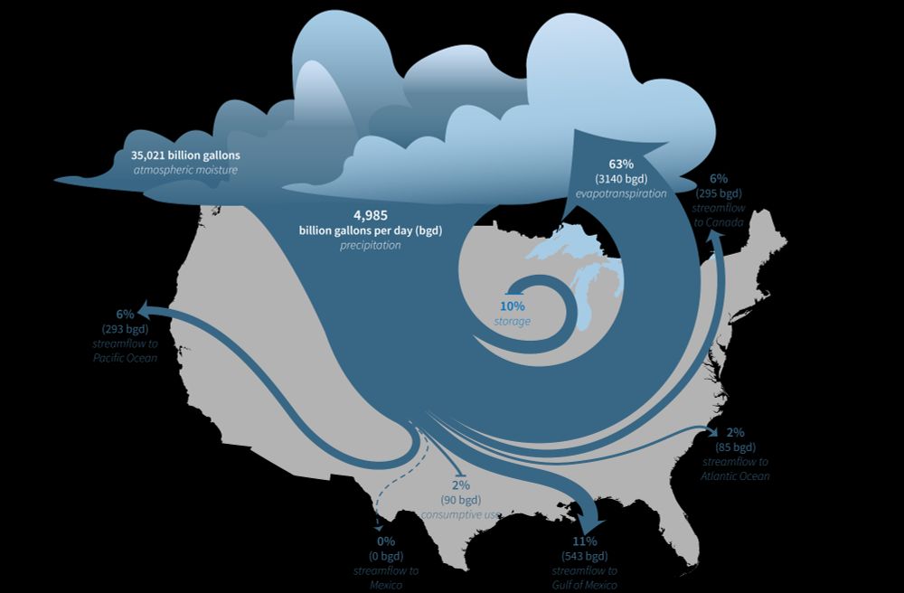
The U.S. Geological Survey (USGS) Vizlab has just released a new, interactive data visualization website about the USGS National Water Availability Assessment Report and Data Companion. Explore the data and the key findings of the assessment at water.usgs.gov/vizlab/water... #DataViz #rstats #USGS
January 16, 2025 at 6:20 PM
The U.S. Geological Survey (USGS) Vizlab has just released a new, interactive data visualization website about the USGS National Water Availability Assessment Report and Data Companion. Explore the data and the key findings of the assessment at water.usgs.gov/vizlab/water... #DataViz #rstats #USGS
A great step towards dynamic scientific articles.
[I thought his voice was familiar - he also did that great video on how to make an effective scientific poster that I gave to all my students]
[I thought his voice was familiar - he also did that great video on how to make an effective scientific poster that I gave to all my students]
Want to see a quick demo of the technology that might replace citations in scientific papers?
Goodbye citations, hello embeds.
I was just hoping for links in scientific papers, but this is even better!
Goodbye citations, hello embeds.
I was just hoping for links in scientific papers, but this is even better!
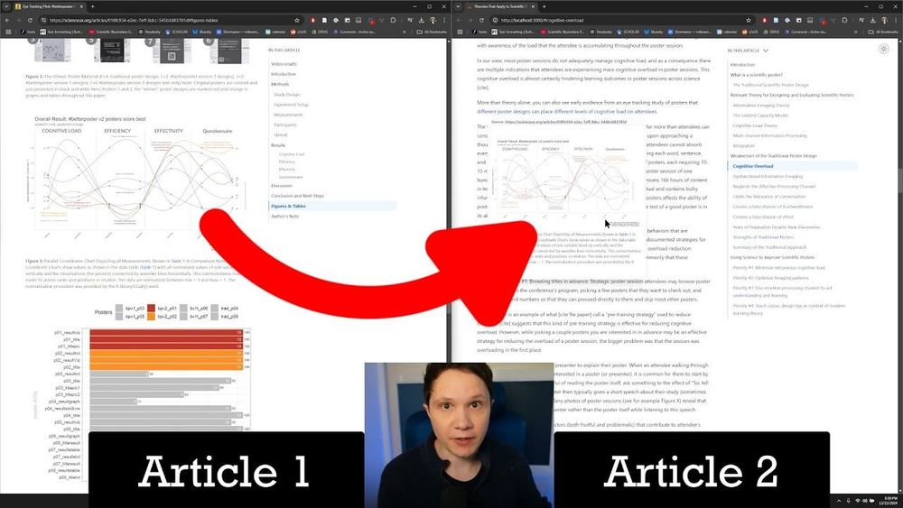
The future of academic citations: Embeds
Citations are dead. Long live embeds! In the future, you won't use traditional citations in scientific articles. You'll directly embed the snippet of science...
youtu.be
January 16, 2025 at 4:34 PM
A great step towards dynamic scientific articles.
[I thought his voice was familiar - he also did that great video on how to make an effective scientific poster that I gave to all my students]
[I thought his voice was familiar - he also did that great video on how to make an effective scientific poster that I gave to all my students]
I love the things we see in streams in the Flow Photo Explorer www.usgs.gov/apps/ecoshed.... Here, in Nevada, a tumbleweed hangs around from Feb to May, finally getting pushed out by some high flow. In case you were wondering, it showed up between 11:15 and 11:30 pm on Feb 4 :)
#flowphotoexplorer
#flowphotoexplorer
December 12, 2024 at 2:10 PM
I love the things we see in streams in the Flow Photo Explorer www.usgs.gov/apps/ecoshed.... Here, in Nevada, a tumbleweed hangs around from Feb to May, finally getting pushed out by some high flow. In case you were wondering, it showed up between 11:15 and 11:30 pm on Feb 4 :)
#flowphotoexplorer
#flowphotoexplorer
Reposted by Ben Letcher

Do you use trail cameras to monitor streams, rivers or other water bodies? Looking for a platform to turn those images into relative flow or stage information? Or even just to look back through all of your images? Check out Flow Photo Explorer! www.usgs.gov/apps/ecoshed...


December 5, 2024 at 6:49 PM
Do you use trail cameras to monitor streams, rivers or other water bodies? Looking for a platform to turn those images into relative flow or stage information? Or even just to look back through all of your images? Check out Flow Photo Explorer! www.usgs.gov/apps/ecoshed...
With hundreds of cameras and millions of photos in our Flow Photos Explorer, we get some cool wildlife pix (screened by megadetector). See the owl?
Nerd alert - we can also tell you within 15 min when the tree top of the stump the owl is sitting on fell. That's got to be valuable to someone, right?
Nerd alert - we can also tell you within 15 min when the tree top of the stump the owl is sitting on fell. That's got to be valuable to someone, right?

November 27, 2024 at 8:45 PM
With hundreds of cameras and millions of photos in our Flow Photos Explorer, we get some cool wildlife pix (screened by megadetector). See the owl?
Nerd alert - we can also tell you within 15 min when the tree top of the stump the owl is sitting on fell. That's got to be valuable to someone, right?
Nerd alert - we can also tell you within 15 min when the tree top of the stump the owl is sitting on fell. That's got to be valuable to someone, right?
And here are 3 streams in Shenandoah NP during hurricane Helene - yikes!
November 22, 2024 at 12:15 AM
And here are 3 streams in Shenandoah NP during hurricane Helene - yikes!
What happens to small streams during a hurricane? Here are time-lapse photos (every 15 min) from our Flow Photos Explorer of 3 sites in PA during Helene. Shocking how high they get and that any fish can survive. They are so flashy, we might even have missed the peak. [gif by Phillip Goodling]
November 22, 2024 at 12:12 AM
What happens to small streams during a hurricane? Here are time-lapse photos (every 15 min) from our Flow Photos Explorer of 3 sites in PA during Helene. Shocking how high they get and that any fish can survive. They are so flashy, we might even have missed the peak. [gif by Phillip Goodling]
The number of images in our Flow Photo Explorer is going up, up, up! It uses trail cameras and machine learning to estimate stream flow, especially in small streams. Anyone can use it!
Check it out: www.usgs.gov/apps/ecoshed...
Check it out: www.usgs.gov/apps/ecoshed...

November 21, 2024 at 6:28 PM
The number of images in our Flow Photo Explorer is going up, up, up! It uses trail cameras and machine learning to estimate stream flow, especially in small streams. Anyone can use it!
Check it out: www.usgs.gov/apps/ecoshed...
Check it out: www.usgs.gov/apps/ecoshed...