


Big Earth Data
@bigearthdata1.bsky.social
Big Earth Data is the world's first big data journal in the Earth sciences.
https://www.tandfonline.com/journals/tbed20
https://www.tandfonline.com/journals/tbed20
📢 Good news! The special issue on “Big data and artificial intelligence for natural hazards” has been published online.
👉https://tandfonline.com/toc/tbed20/9/3?nav=tocList
#flood #drought #wildfire #bigdata #AI #remotesensing #disaster #hazard #earthobservation #GIS #GeoAI #SDGs
👉https://tandfonline.com/toc/tbed20/9/3?nav=tocList
#flood #drought #wildfire #bigdata #AI #remotesensing #disaster #hazard #earthobservation #GIS #GeoAI #SDGs

November 5, 2025 at 8:05 AM
📢Assessing future risk of humanitarian crises using projections of climate-related hazards, population, conflict and other socioeconomic variables within the INFORM framework
👉https://doi.org/10.1080/20964471.2025.2535852
💌 #INFORM #climatechange #hazard #SSPs #risk #remotesensing #GIS #BigData
👉https://doi.org/10.1080/20964471.2025.2535852
💌 #INFORM #climatechange #hazard #SSPs #risk #remotesensing #GIS #BigData


October 27, 2025 at 2:07 PM
📢Assessing future risk of humanitarian crises using projections of climate-related hazards, population, conflict and other socioeconomic variables within the INFORM framework
👉https://doi.org/10.1080/20964471.2025.2535852
💌 #INFORM #climatechange #hazard #SSPs #risk #remotesensing #GIS #BigData
👉https://doi.org/10.1080/20964471.2025.2535852
💌 #INFORM #climatechange #hazard #SSPs #risk #remotesensing #GIS #BigData
📢We're delighted to announce a new special issue: lnkd.in/gKesFKT9. If you are engaged in this dynamic field, we warmly invite you to contribute your valuable insights!
#remotesensing #earthobservation #ArtificialIntelligence #ai #MachineLearning #Geospatial #DataScience #SustainableDevelopment
#remotesensing #earthobservation #ArtificialIntelligence #ai #MachineLearning #Geospatial #DataScience #SustainableDevelopment

October 14, 2025 at 9:19 AM
📢We're delighted to announce a new special issue: lnkd.in/gKesFKT9. If you are engaged in this dynamic field, we warmly invite you to contribute your valuable insights!
#remotesensing #earthobservation #ArtificialIntelligence #ai #MachineLearning #Geospatial #DataScience #SustainableDevelopment
#remotesensing #earthobservation #ArtificialIntelligence #ai #MachineLearning #Geospatial #DataScience #SustainableDevelopment
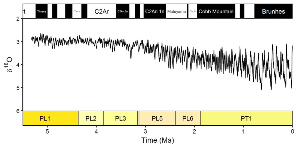
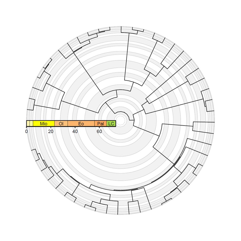
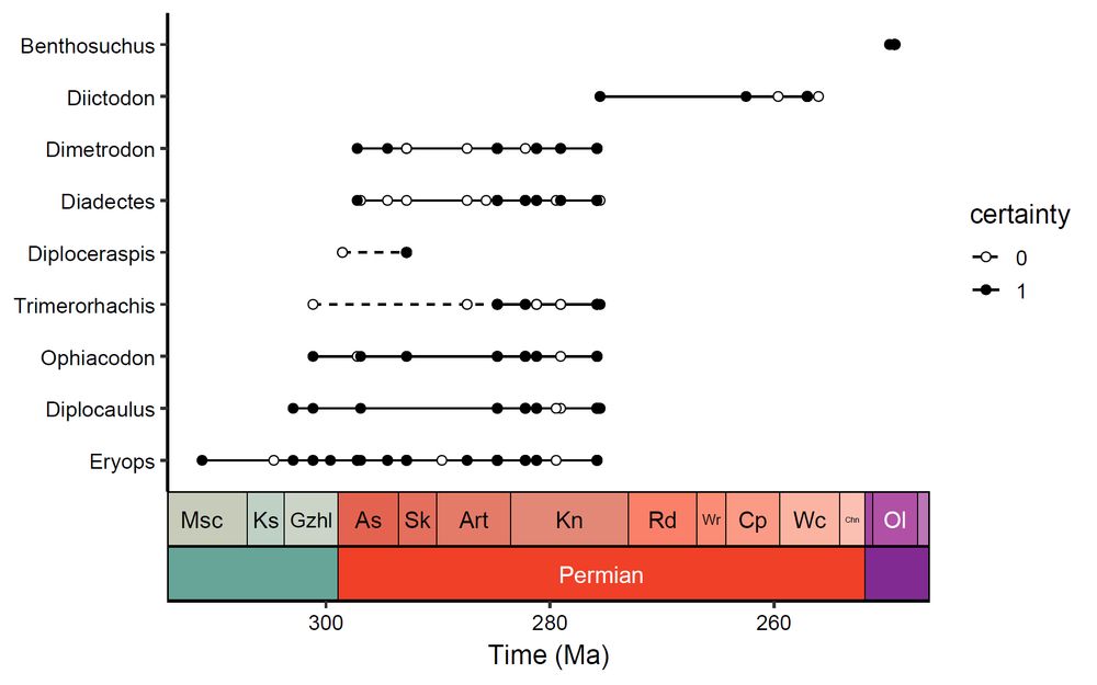
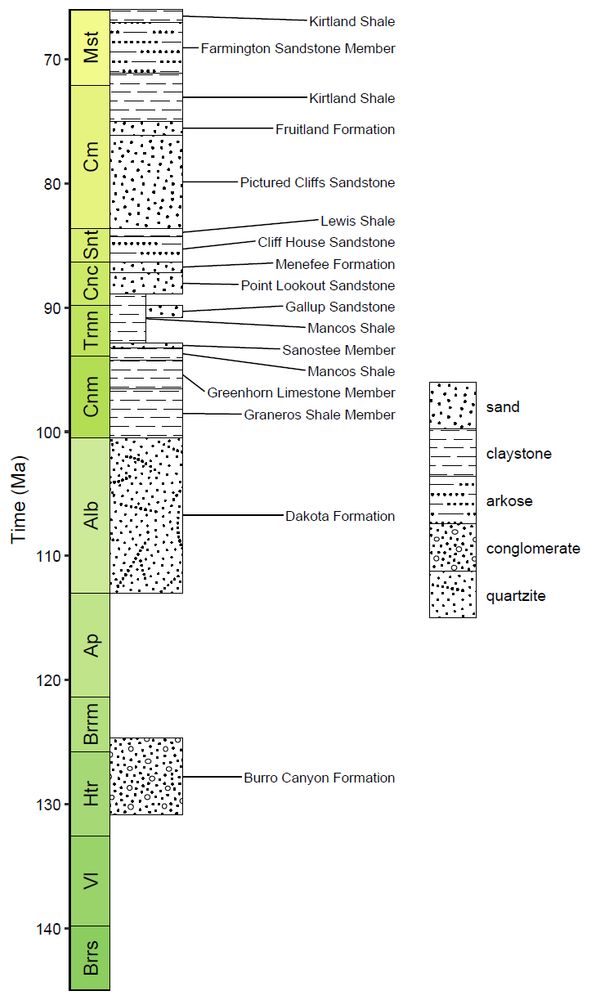
📢deeptime: an #R package that facilitates highly customizable and reproducible visualizations of data over geological time intervals by William Gearty @willgearty.bsky.social
👉https://doi.org/10.1080/20964471.2025.2537516
#Datavisualization #reproducibility #opensource #paleontology #geology
👉https://doi.org/10.1080/20964471.2025.2537516
#Datavisualization #reproducibility #opensource #paleontology #geology

deeptime: an R package that facilitates highly customizable and reproducible visualizations of data over geological time intervals
Data visualization is a key component of any scientific data analysis workflow and is vital for the summarization and dissemination of complex ideas and results. One common hurdle across the Earth ...
doi.org
September 29, 2025 at 9:09 AM
📢deeptime: an #R package that facilitates highly customizable and reproducible visualizations of data over geological time intervals by William Gearty @willgearty.bsky.social
👉https://doi.org/10.1080/20964471.2025.2537516
#Datavisualization #reproducibility #opensource #paleontology #geology
👉https://doi.org/10.1080/20964471.2025.2537516
#Datavisualization #reproducibility #opensource #paleontology #geology
Reposted by Big Earth Data

It's so great to see this package (on CRAN since 2021) finally formally described in a journal! Here's to many more years of standardized, customizable, and reproducible geology data visualization!
And shout out to @richardstockey.bsky.social and @lewisajones.bsky.social for years of encouragement!
And shout out to @richardstockey.bsky.social and @lewisajones.bsky.social for years of encouragement!
August 6, 2025 at 1:15 PM
It's so great to see this package (on CRAN since 2021) finally formally described in a journal! Here's to many more years of standardized, customizable, and reproducible geology data visualization!
And shout out to @richardstockey.bsky.social and @lewisajones.bsky.social for years of encouragement!
And shout out to @richardstockey.bsky.social and @lewisajones.bsky.social for years of encouragement!
📢 [Research Article] A novel ensemble model for multi-temporal forest vegetation classification: integrating spectral-temporal features and topographic constraints
👉Article link: doi.org/10.1080/2096...
💌 #Sentinel1 #Sentinel2 #deeplearning #remotesensing #landuse #landcover #forestmapping
👉Article link: doi.org/10.1080/2096...
💌 #Sentinel1 #Sentinel2 #deeplearning #remotesensing #landuse #landcover #forestmapping
A novel ensemble model for multi-temporal forest vegetation classification: integrating spectral-temporal features and topographic constraints
Understanding species distribution in large forest ecosystems is fundamental for biodiversity conservation, biomass estimation, climate regulation, soil and water conservation. While remote sensing...
doi.org
September 19, 2025 at 9:02 AM
📢 [Research Article] A novel ensemble model for multi-temporal forest vegetation classification: integrating spectral-temporal features and topographic constraints
👉Article link: doi.org/10.1080/2096...
💌 #Sentinel1 #Sentinel2 #deeplearning #remotesensing #landuse #landcover #forestmapping
👉Article link: doi.org/10.1080/2096...
💌 #Sentinel1 #Sentinel2 #deeplearning #remotesensing #landuse #landcover #forestmapping
📢 [Review Article] Harnessing generative AI for enhanced disaster management: a systematic review
👉Article link: doi.org/10.1080/2096...
#Artificialintelligence #disastermanagement #riskmanagement #largelanguagemodel #bigearthdata #digitalearth #geoscience #remotesensing #GIS #risk
👉Article link: doi.org/10.1080/2096...
#Artificialintelligence #disastermanagement #riskmanagement #largelanguagemodel #bigearthdata #digitalearth #geoscience #remotesensing #GIS #risk

Harnessing generative AI for enhanced disaster management: a systematic review
In the consistently evolving artificial intelligence (AI) and large language models (LLMs), many organizations adopt these technologies’ capabilities to solve and assist core operations in many ind...
doi.org
September 10, 2025 at 7:57 AM
📢 [Review Article] Harnessing generative AI for enhanced disaster management: a systematic review
👉Article link: doi.org/10.1080/2096...
#Artificialintelligence #disastermanagement #riskmanagement #largelanguagemodel #bigearthdata #digitalearth #geoscience #remotesensing #GIS #risk
👉Article link: doi.org/10.1080/2096...
#Artificialintelligence #disastermanagement #riskmanagement #largelanguagemodel #bigearthdata #digitalearth #geoscience #remotesensing #GIS #risk
📢Spatial sample weighted machine learning for multitemporal land cover change modeling with imbalanced datasets by Alysha van Duynhoven & Suzana Dragićević
👉https://doi.org/10.1080/20964471.2025.2518763
#machinelearning #landcover #AI #GeoAI #remotesensing #earthobservation #GIS
👉https://doi.org/10.1080/20964471.2025.2518763
#machinelearning #landcover #AI #GeoAI #remotesensing #earthobservation #GIS


September 2, 2025 at 12:24 PM
📢Spatial sample weighted machine learning for multitemporal land cover change modeling with imbalanced datasets by Alysha van Duynhoven & Suzana Dragićević
👉https://doi.org/10.1080/20964471.2025.2518763
#machinelearning #landcover #AI #GeoAI #remotesensing #earthobservation #GIS
👉https://doi.org/10.1080/20964471.2025.2518763
#machinelearning #landcover #AI #GeoAI #remotesensing #earthobservation #GIS
Reposted by Big Earth Data
📢 deeptime: an R package that facilitates highly customizable and reproducible visualizations of data over geological time intervals
🔗 doi.org/10.1080/2096...
Fully #openaccess in @bigearthdata1.bsky.social with insight about deeptime📦 development and code examples!
#rstats #geology #paleontology
🔗 doi.org/10.1080/2096...
Fully #openaccess in @bigearthdata1.bsky.social with insight about deeptime📦 development and code examples!
#rstats #geology #paleontology
August 6, 2025 at 1:06 PM
📢 deeptime: an R package that facilitates highly customizable and reproducible visualizations of data over geological time intervals
🔗 doi.org/10.1080/2096...
Fully #openaccess in @bigearthdata1.bsky.social with insight about deeptime📦 development and code examples!
#rstats #geology #paleontology
🔗 doi.org/10.1080/2096...
Fully #openaccess in @bigearthdata1.bsky.social with insight about deeptime📦 development and code examples!
#rstats #geology #paleontology
📢Simulation of lake underwater terrain based on the XGBoost model: a case study of typical lakes on the #TibetanPlateau
👉https://doi.org/10.1080/20964471.2025.2515713
#lake #underwater #terrain #XGBoost #topography #DEM #waterstorage #bathymetry #climatechange #hydrology #3D #remotesensing #GIS
👉https://doi.org/10.1080/20964471.2025.2515713
#lake #underwater #terrain #XGBoost #topography #DEM #waterstorage #bathymetry #climatechange #hydrology #3D #remotesensing #GIS


August 20, 2025 at 9:37 AM
📢Simulation of lake underwater terrain based on the XGBoost model: a case study of typical lakes on the #TibetanPlateau
👉https://doi.org/10.1080/20964471.2025.2515713
#lake #underwater #terrain #XGBoost #topography #DEM #waterstorage #bathymetry #climatechange #hydrology #3D #remotesensing #GIS
👉https://doi.org/10.1080/20964471.2025.2515713
#lake #underwater #terrain #XGBoost #topography #DEM #waterstorage #bathymetry #climatechange #hydrology #3D #remotesensing #GIS
📢DACIA5: a #Sentinel-1 and #Sentinel-2 #dataset for agricultural #crop identification applications by A. Băicoianu, I. C. Plajer, M. Debu, et al.
👉Article link: doi.org/10.1080/2096...
💌 #Artificialintelligence #agriculture #smartagriculture #remotesensing #machinelearning #datasharing #datapaper
👉Article link: doi.org/10.1080/2096...
💌 #Artificialintelligence #agriculture #smartagriculture #remotesensing #machinelearning #datasharing #datapaper


August 4, 2025 at 6:18 AM
📢DACIA5: a #Sentinel-1 and #Sentinel-2 #dataset for agricultural #crop identification applications by A. Băicoianu, I. C. Plajer, M. Debu, et al.
👉Article link: doi.org/10.1080/2096...
💌 #Artificialintelligence #agriculture #smartagriculture #remotesensing #machinelearning #datasharing #datapaper
👉Article link: doi.org/10.1080/2096...
💌 #Artificialintelligence #agriculture #smartagriculture #remotesensing #machinelearning #datasharing #datapaper
📢[Research Article] Modeling #deforestation drivers in the Brazilian #Amazon: a comparison of quantitative approaches by Alisson Castro Barreto, Tailon Martins & Adriano Mendonça Souza
👉https://doi.org/10.1080/20964471.2025.2510770
#biome #geoscience #GIS #remotesensing #Brazil #statisticalmethod
👉https://doi.org/10.1080/20964471.2025.2510770
#biome #geoscience #GIS #remotesensing #Brazil #statisticalmethod


July 25, 2025 at 10:06 AM
📢[Research Article] Modeling #deforestation drivers in the Brazilian #Amazon: a comparison of quantitative approaches by Alisson Castro Barreto, Tailon Martins & Adriano Mendonça Souza
👉https://doi.org/10.1080/20964471.2025.2510770
#biome #geoscience #GIS #remotesensing #Brazil #statisticalmethod
👉https://doi.org/10.1080/20964471.2025.2510770
#biome #geoscience #GIS #remotesensing #Brazil #statisticalmethod
📢GeoFactory: an #LLM performance enhancement framework for geoscience factual and inferential tasks
👉https://doi.org/10.1080/20964471.2025.2506291
💌A guidance for adapting LLMs to #geoscience applications and paves the way for future multimodal implementations. Largelanguagemodel
👉https://doi.org/10.1080/20964471.2025.2506291
💌A guidance for adapting LLMs to #geoscience applications and paves the way for future multimodal implementations. Largelanguagemodel


July 18, 2025 at 4:10 AM
📢GeoFactory: an #LLM performance enhancement framework for geoscience factual and inferential tasks
👉https://doi.org/10.1080/20964471.2025.2506291
💌A guidance for adapting LLMs to #geoscience applications and paves the way for future multimodal implementations. Largelanguagemodel
👉https://doi.org/10.1080/20964471.2025.2506291
💌A guidance for adapting LLMs to #geoscience applications and paves the way for future multimodal implementations. Largelanguagemodel
📢 Daily-scale dataset of highly dynamic water of Poyang Lake
👉Article link: doi.org/10.1080/2096...
💌 #Remotelysensing #PoyangLake #randomforest #hydrology #landcover #opticalimagery #SAR #WaterIndex
👉Article link: doi.org/10.1080/2096...
💌 #Remotelysensing #PoyangLake #randomforest #hydrology #landcover #opticalimagery #SAR #WaterIndex


July 4, 2025 at 9:35 AM
📢 Daily-scale dataset of highly dynamic water of Poyang Lake
👉Article link: doi.org/10.1080/2096...
💌 #Remotelysensing #PoyangLake #randomforest #hydrology #landcover #opticalimagery #SAR #WaterIndex
👉Article link: doi.org/10.1080/2096...
💌 #Remotelysensing #PoyangLake #randomforest #hydrology #landcover #opticalimagery #SAR #WaterIndex
📢 Classification of oil palm tree conditions from #UAV imagery using the #YOLO object detector by Aakash Thapa, Teerayut Horanont et al.
👉Article link: doi.org/10.1080/2096...
💌 #Oilpalmtree #deeplearning #YOLOv8 #YOLO #objectdetection #precisionagriculture #remotesensing
👉Article link: doi.org/10.1080/2096...
💌 #Oilpalmtree #deeplearning #YOLOv8 #YOLO #objectdetection #precisionagriculture #remotesensing


June 24, 2025 at 2:41 AM
📢 Classification of oil palm tree conditions from #UAV imagery using the #YOLO object detector by Aakash Thapa, Teerayut Horanont et al.
👉Article link: doi.org/10.1080/2096...
💌 #Oilpalmtree #deeplearning #YOLOv8 #YOLO #objectdetection #precisionagriculture #remotesensing
👉Article link: doi.org/10.1080/2096...
💌 #Oilpalmtree #deeplearning #YOLOv8 #YOLO #objectdetection #precisionagriculture #remotesensing
📢[Research Article] Detection of #drainage ditches from #LiDAR #DTM using U-Net and transfer learning by Holger Virro, Alexander Kmoch, et al.
👉Article link: doi.org/10.1080/2096...
💌 #remotesensing #hydrology
👉Article link: doi.org/10.1080/2096...
💌 #remotesensing #hydrology

Detection of drainage ditches from LiDAR DTM using U-Net and transfer learning
Accurate mapping of ditches is essential for effective hydrological modeling and land management. Traditional methods, such as manual digitization or threshold-based extraction, utilize LiDAR-deriv...
doi.org
June 18, 2025 at 4:07 AM
📢[Research Article] Detection of #drainage ditches from #LiDAR #DTM using U-Net and transfer learning by Holger Virro, Alexander Kmoch, et al.
👉Article link: doi.org/10.1080/2096...
💌 #remotesensing #hydrology
👉Article link: doi.org/10.1080/2096...
💌 #remotesensing #hydrology
📢A deep learning pipeline to #powerinfrastructure detection in #highresolution satellite images by Mengqi Ye et al.
👉https://doi.org/10.1080/20964471.2025.2490408
💌It highlights the potential of #deeplearning for large-scale #power grid mapping using from #Worldview-3 imagery.
#remotesensing
👉https://doi.org/10.1080/20964471.2025.2490408
💌It highlights the potential of #deeplearning for large-scale #power grid mapping using from #Worldview-3 imagery.
#remotesensing


June 10, 2025 at 3:08 AM
📢A deep learning pipeline to #powerinfrastructure detection in #highresolution satellite images by Mengqi Ye et al.
👉https://doi.org/10.1080/20964471.2025.2490408
💌It highlights the potential of #deeplearning for large-scale #power grid mapping using from #Worldview-3 imagery.
#remotesensing
👉https://doi.org/10.1080/20964471.2025.2490408
💌It highlights the potential of #deeplearning for large-scale #power grid mapping using from #Worldview-3 imagery.
#remotesensing
📢 [New Article] A multi-rule index to extract brine shrimp from satellite imagery: a case study in Ebinur Lake, China
👉Article link: doi.org/10.1080/2096...
Study uses #Landsat data to map #Artemia in China’s #EbinurLake, achieving 94.5% accuracy. #RemoteSensing #BrineShrimp #Conservation
👉Article link: doi.org/10.1080/2096...
Study uses #Landsat data to map #Artemia in China’s #EbinurLake, achieving 94.5% accuracy. #RemoteSensing #BrineShrimp #Conservation


June 3, 2025 at 3:50 AM
📢 [New Article] A multi-rule index to extract brine shrimp from satellite imagery: a case study in Ebinur Lake, China
👉Article link: doi.org/10.1080/2096...
Study uses #Landsat data to map #Artemia in China’s #EbinurLake, achieving 94.5% accuracy. #RemoteSensing #BrineShrimp #Conservation
👉Article link: doi.org/10.1080/2096...
Study uses #Landsat data to map #Artemia in China’s #EbinurLake, achieving 94.5% accuracy. #RemoteSensing #BrineShrimp #Conservation
📢 Enhancing geodatabases operability: advanced human-computer interaction through #RAG and Multi-Agent Systems
👉Article link: doi.org/10.1080/2096...
#LargeLanguageModel #LLM #MultiAgentSystem #SQL #geospatialdatabases #GeoAI #GIS #dataquery #datamanagement #geodatabase
👉Article link: doi.org/10.1080/2096...
#LargeLanguageModel #LLM #MultiAgentSystem #SQL #geospatialdatabases #GeoAI #GIS #dataquery #datamanagement #geodatabase


May 27, 2025 at 3:31 AM
📢 Enhancing geodatabases operability: advanced human-computer interaction through #RAG and Multi-Agent Systems
👉Article link: doi.org/10.1080/2096...
#LargeLanguageModel #LLM #MultiAgentSystem #SQL #geospatialdatabases #GeoAI #GIS #dataquery #datamanagement #geodatabase
👉Article link: doi.org/10.1080/2096...
#LargeLanguageModel #LLM #MultiAgentSystem #SQL #geospatialdatabases #GeoAI #GIS #dataquery #datamanagement #geodatabase
📢 [Review Article] Exploring the concept of digital twins of wetlands for supporting ecosystem monitoring and management by Bing Lu et al.
👉Article link: doi.org/10.1080/2096...
💌 #Wetland #remotesensing #GIS #ecosystem #digitaltwins
👉Article link: doi.org/10.1080/2096...
💌 #Wetland #remotesensing #GIS #ecosystem #digitaltwins


May 12, 2025 at 2:54 AM
📢 [Review Article] Exploring the concept of digital twins of wetlands for supporting ecosystem monitoring and management by Bing Lu et al.
👉Article link: doi.org/10.1080/2096...
💌 #Wetland #remotesensing #GIS #ecosystem #digitaltwins
👉Article link: doi.org/10.1080/2096...
💌 #Wetland #remotesensing #GIS #ecosystem #digitaltwins
📢Li-GS: a fast #3D Gaussian reconstruction method assisted by LiDAR point clouds
👉Article link: doi.org/10.1080/2096...
💌Li-GS uses #LiDAR #pointclouds and dynamic voxel filtering to accelerate training while improving #geometric accuracy and reducing hardware demands.
#remotesensing #digitaltwin
👉Article link: doi.org/10.1080/2096...
💌Li-GS uses #LiDAR #pointclouds and dynamic voxel filtering to accelerate training while improving #geometric accuracy and reducing hardware demands.
#remotesensing #digitaltwin


April 27, 2025 at 2:30 AM
📢Li-GS: a fast #3D Gaussian reconstruction method assisted by LiDAR point clouds
👉Article link: doi.org/10.1080/2096...
💌Li-GS uses #LiDAR #pointclouds and dynamic voxel filtering to accelerate training while improving #geometric accuracy and reducing hardware demands.
#remotesensing #digitaltwin
👉Article link: doi.org/10.1080/2096...
💌Li-GS uses #LiDAR #pointclouds and dynamic voxel filtering to accelerate training while improving #geometric accuracy and reducing hardware demands.
#remotesensing #digitaltwin
📢[Data Note] Restoration of missing #oceancolor data in high-latitude oceans using neural network model
👉https://doi.org/10.1080/20964471.2025.2474655
💌The NN-LAT50 #dataset for #highlatitude #oceans significantly improves retrieval accuracy and winter coverage. #polar #remotesensing #oceanography
👉https://doi.org/10.1080/20964471.2025.2474655
💌The NN-LAT50 #dataset for #highlatitude #oceans significantly improves retrieval accuracy and winter coverage. #polar #remotesensing #oceanography


April 17, 2025 at 3:09 AM
📢[Data Note] Restoration of missing #oceancolor data in high-latitude oceans using neural network model
👉https://doi.org/10.1080/20964471.2025.2474655
💌The NN-LAT50 #dataset for #highlatitude #oceans significantly improves retrieval accuracy and winter coverage. #polar #remotesensing #oceanography
👉https://doi.org/10.1080/20964471.2025.2474655
💌The NN-LAT50 #dataset for #highlatitude #oceans significantly improves retrieval accuracy and winter coverage. #polar #remotesensing #oceanography
Reposted by Big Earth Data

🔥 This Wednesday, I reached a major milestone: I successfully completed my #PhD journey by defending my thesis ‘Advancing #Forest Monitoring using #Sentinel1 C-band #SAR Time Series and #MachineLearning Approaches' at the @sciencecharles.bsky.social @charlesuni.cuni.cz
Details on my thesis 👇
Details on my thesis 👇

February 14, 2025 at 12:12 PM
🔥 This Wednesday, I reached a major milestone: I successfully completed my #PhD journey by defending my thesis ‘Advancing #Forest Monitoring using #Sentinel1 C-band #SAR Time Series and #MachineLearning Approaches' at the @sciencecharles.bsky.social @charlesuni.cuni.cz
Details on my thesis 👇
Details on my thesis 👇
📢Interactive Earth system data cube visualization in Jupyter notebooks by Maximilian Söchting (@soechting.bsky.social), Miguel D. Mahecha (@miguelmahecha.bsky.social) et al.
👉https://doi.org/10.1080/20964471.2025.2471646
#opensource #3D #datacube #visualization #Jupyter #geoscience #remotesensing
👉https://doi.org/10.1080/20964471.2025.2471646
#opensource #3D #datacube #visualization #Jupyter #geoscience #remotesensing


April 3, 2025 at 7:13 AM
📢Interactive Earth system data cube visualization in Jupyter notebooks by Maximilian Söchting (@soechting.bsky.social), Miguel D. Mahecha (@miguelmahecha.bsky.social) et al.
👉https://doi.org/10.1080/20964471.2025.2471646
#opensource #3D #datacube #visualization #Jupyter #geoscience #remotesensing
👉https://doi.org/10.1080/20964471.2025.2471646
#opensource #3D #datacube #visualization #Jupyter #geoscience #remotesensing
Reposted by Big Earth Data

Excited to share the latest paper emerging from the fantastic PhD thesis of @soechting.bsky.social! Interactive Earth System Data Cube visualization in Jupyter Notebooks! www.tandfonline.com/doi/full/10....

March 5, 2025 at 9:42 PM
Excited to share the latest paper emerging from the fantastic PhD thesis of @soechting.bsky.social! Interactive Earth System Data Cube visualization in Jupyter Notebooks! www.tandfonline.com/doi/full/10....