


Alex Krull
@akrullj.bsky.social
Meteorologist. B.S. Valparaiso. M.S. Nebraska. Severe Thunderstorms. Mesoanalysis. Little Python. Little WRF. Little CM1. Always ready to click WarnGen. Opinions/content are my own.
Pinned
Alex Krull
@akrullj.bsky.social
· Oct 18

Hi. I'm Alex, an operational meteorologist. I focus mostly on #SevereThunderstorms, via mesoanalysis to assess their background environment, and 88D radar signatures. I don't have any recent #tornado pictures. Most of my posts will involve sounding and radar images. I do some limited Python stuff.
Very disheartened by the UNL chancellor's decision to recommend the Earth & Atmospheric Sciences Department for elimination, despite the opposition from the Academic Planning Committee's vote.
Both the opposing and in favor summary noted the value EAS provides to the discipline, and both sides
Both the opposing and in favor summary noted the value EAS provides to the discipline, and both sides
November 11, 2025 at 3:23 AM
Very disheartened by the UNL chancellor's decision to recommend the Earth & Atmospheric Sciences Department for elimination, despite the opposition from the Academic Planning Committee's vote.
Both the opposing and in favor summary noted the value EAS provides to the discipline, and both sides
Both the opposing and in favor summary noted the value EAS provides to the discipline, and both sides
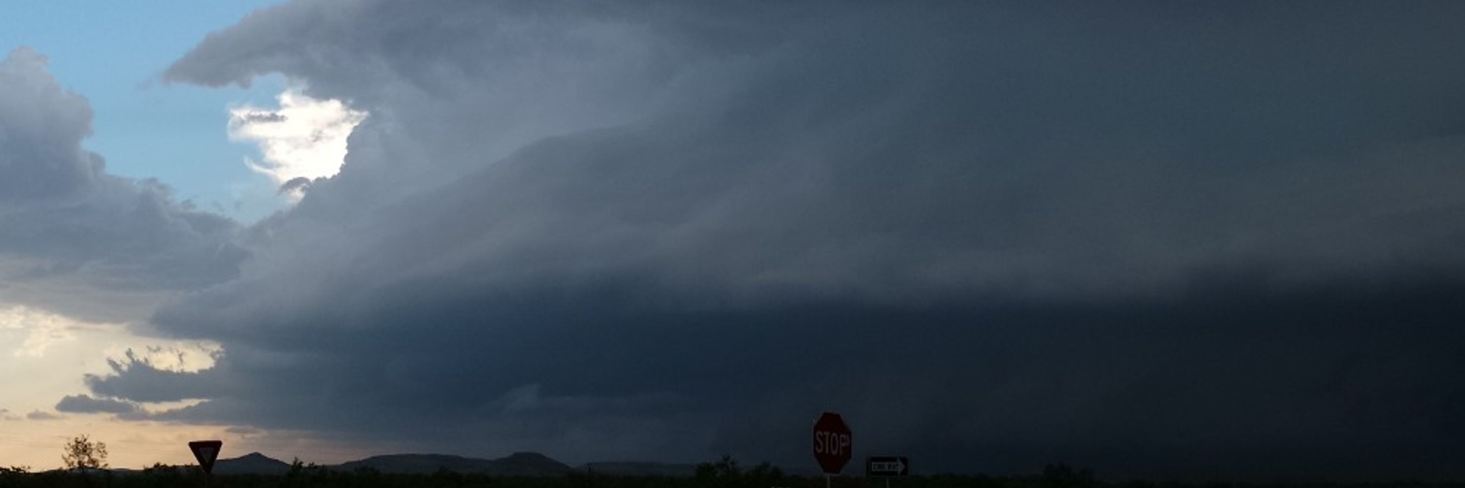
Windy in Fort Worth.
October 25, 2025 at 1:47 AM
Windy in Fort Worth.
They needed to ice the kicker, but didn't have any timeouts left. So they did this...

October 5, 2025 at 12:42 AM
They needed to ice the kicker, but didn't have any timeouts left. So they did this...
Welp, in the market again for a computer monitor setup.
Not much of a gamer. Mainly do some coding and lots of GR2 viewing.
I have been using 2, 24" monitors. Do I stick with dual monitors, or, do I go to a larger curved monitor (but overall slightly less screen real-estate).
Not much of a gamer. Mainly do some coding and lots of GR2 viewing.
I have been using 2, 24" monitors. Do I stick with dual monitors, or, do I go to a larger curved monitor (but overall slightly less screen real-estate).
August 14, 2025 at 10:01 PM
Welp, in the market again for a computer monitor setup.
Not much of a gamer. Mainly do some coding and lots of GR2 viewing.
I have been using 2, 24" monitors. Do I stick with dual monitors, or, do I go to a larger curved monitor (but overall slightly less screen real-estate).
Not much of a gamer. Mainly do some coding and lots of GR2 viewing.
I have been using 2, 24" monitors. Do I stick with dual monitors, or, do I go to a larger curved monitor (but overall slightly less screen real-estate).
Don't let the storm's odometer countdown to Derecho criteria get in the way recognizing the substantial wind threat this environment will support. There is a lot of moisture available, and, it's distributed in such a way to favor precip loading and strong evaporational cooling.


July 29, 2025 at 12:54 AM
Don't let the storm's odometer countdown to Derecho criteria get in the way recognizing the substantial wind threat this environment will support. There is a lot of moisture available, and, it's distributed in such a way to favor precip loading and strong evaporational cooling.
That was the biggest pain in the [neck] mesoscale storm environment I have ever had to try and navigate. Somehow outflow boundaries formed new outflow boundaries. The big lesson: We have a long way to go in CAMs handling cold pools.
June 29, 2025 at 10:18 PM
That was the biggest pain in the [neck] mesoscale storm environment I have ever had to try and navigate. Somehow outflow boundaries formed new outflow boundaries. The big lesson: We have a long way to go in CAMs handling cold pools.
I know we have supercells in the Northern Plains, but very interesting occurrence in Nebraska. Weak showers producing 70+mph winds. Big time evaporative cooling. Boundary layer lapse rates 9.2 C/km.

June 29, 2025 at 2:49 AM
I know we have supercells in the Northern Plains, but very interesting occurrence in Nebraska. Weak showers producing 70+mph winds. Big time evaporative cooling. Boundary layer lapse rates 9.2 C/km.
RIJ working efficiently to 1.) Increase strength of bookend vortex and 2.) Align the leading edge favorable for more robust meso vortex generation. A lot of available vorticity north of Interstate 94.

June 21, 2025 at 3:56 AM
RIJ working efficiently to 1.) Increase strength of bookend vortex and 2.) Align the leading edge favorable for more robust meso vortex generation. A lot of available vorticity north of Interstate 94.
Quite the day in North Dakota. Two discrete supercells eastward, with ranging bowing MCS across the middle.

June 21, 2025 at 2:39 AM
Quite the day in North Dakota. Two discrete supercells eastward, with ranging bowing MCS across the middle.
Impressive LEWP in Oklahoma.

June 18, 2025 at 4:23 AM
Impressive LEWP in Oklahoma.
Another supercell has developed. Thinking maybe this formed along a convergent zone of the previous RFD, or, could be another outflow that was sitting there from the previous convection.

April 28, 2025 at 2:03 AM
Another supercell has developed. Thinking maybe this formed along a convergent zone of the previous RFD, or, could be another outflow that was sitting there from the previous convection.
A lot of cell mergers tonight in the Nebraska panhandle.

April 28, 2025 at 12:54 AM
A lot of cell mergers tonight in the Nebraska panhandle.
This supercell southwest of Lubbock has been fascinating to watch. Storm motion has been slow. This has allowed for a deviant rightward turns, drastically increasing SRH (and becomes much more streamwise). Also noticing the LVFE develop as these right turns occur, then low-level meso intensifies.

April 25, 2025 at 2:38 AM
This supercell southwest of Lubbock has been fascinating to watch. Storm motion has been slow. This has allowed for a deviant rightward turns, drastically increasing SRH (and becomes much more streamwise). Also noticing the LVFE develop as these right turns occur, then low-level meso intensifies.
Quite the hard right turn this supercell took.

April 25, 2025 at 1:19 AM
Quite the hard right turn this supercell took.
Storm near I-80 is trying to re-intensify. Thinking LLJ may be providing low-level shear. ZDR arc is evident again. Main question is how unstable can the boundary layer remain as the night progresses.


April 18, 2025 at 2:38 AM
Storm near I-80 is trying to re-intensify. Thinking LLJ may be providing low-level shear. ZDR arc is evident again. Main question is how unstable can the boundary layer remain as the night progresses.
Deviant tornado motion? @cameronjnixon.bsky.social

April 18, 2025 at 2:11 AM
Deviant tornado motion? @cameronjnixon.bsky.social
This supercell when in it was in Nebraska had some new updrafts to the rear of it that tried to move left but died. Now, as a strong (with high potential of being violent) tornadic supercell, noticed that the hodograph in Iowa may not suppress left movers as much as the 2-4km winds back.


April 18, 2025 at 1:57 AM
This supercell when in it was in Nebraska had some new updrafts to the rear of it that tried to move left but died. Now, as a strong (with high potential of being violent) tornadic supercell, noticed that the hodograph in Iowa may not suppress left movers as much as the 2-4km winds back.
Getting 65 kts vrot about 3600ft AGl. SR flow was very strong, and this storm deviated further to the right as this low-level meso strengthened. Noticing that we don't have cell merger nudgers today, so these storms are taking longer to produce, but the background environment has enough to pull from

April 18, 2025 at 1:27 AM
Getting 65 kts vrot about 3600ft AGl. SR flow was very strong, and this storm deviated further to the right as this low-level meso strengthened. Noticing that we don't have cell merger nudgers today, so these storms are taking longer to produce, but the background environment has enough to pull from
ZDR Arc reappeared on this supercell, turned right a little bit, and had a tornado report on it.

April 18, 2025 at 1:10 AM
ZDR Arc reappeared on this supercell, turned right a little bit, and had a tornado report on it.
The supercell east of Lincoln appears to be ocludding. Notice though the extremely high spectrum width into the inflow of this storm, and also notice that RFD surge as this happens is getting back to the outflow. In this shear environment, new low-level meso could be able to easily develop.

April 18, 2025 at 12:38 AM
The supercell east of Lincoln appears to be ocludding. Notice though the extremely high spectrum width into the inflow of this storm, and also notice that RFD surge as this happens is getting back to the outflow. In this shear environment, new low-level meso could be able to easily develop.
Both the mean wind and right moving storm motions on this hodographs have strong, streamwise vorticity present. And overall strong shear allows for deep updrafts, favorable for hail because you are getting monster supercells.
Notice though, that when this northern Omaha Metro storm took a right
Notice though, that when this northern Omaha Metro storm took a right

April 18, 2025 at 12:27 AM
Both the mean wind and right moving storm motions on this hodographs have strong, streamwise vorticity present. And overall strong shear allows for deep updrafts, favorable for hail because you are getting monster supercells.
Notice though, that when this northern Omaha Metro storm took a right
Notice though, that when this northern Omaha Metro storm took a right
Prior to the 20kft+ TDS appearing, this particular supercell received a strong nudge from another supercell behind it and seems to fit @cameronjnixon.bsky.social paper fundamentals very well.
April 2, 2025 at 11:50 PM
Prior to the 20kft+ TDS appearing, this particular supercell received a strong nudge from another supercell behind it and seems to fit @cameronjnixon.bsky.social paper fundamentals very well.
Wow, not very often you see nearly every single updraft be a supercell.

April 2, 2025 at 11:23 PM
Wow, not very often you see nearly every single updraft be a supercell.
Earlier runs of the HRRR had this as a favored corridor for stronger supercell(s). However, this may exit the better instability and moisture before it can really get going. LCLs may not quite be there, but LLJ is still pumping more moisture into the region.

April 2, 2025 at 1:02 AM
Earlier runs of the HRRR had this as a favored corridor for stronger supercell(s). However, this may exit the better instability and moisture before it can really get going. LCLs may not quite be there, but LLJ is still pumping more moisture into the region.
HRRR sounding from eastern Kansas this evening, selected from area downstream of where two stronger updrafts initiate. HRRR continues to mix boundary layer quite well, with strong EML still providing some cap. However, stronger theta-e transport this afternoon below 850mb may mitigate the mixing

April 1, 2025 at 3:12 PM
HRRR sounding from eastern Kansas this evening, selected from area downstream of where two stronger updrafts initiate. HRRR continues to mix boundary layer quite well, with strong EML still providing some cap. However, stronger theta-e transport this afternoon below 850mb may mitigate the mixing