Robin Hogan
banner
robinjhogan.bsky.social
Robin Hogan
@robinjhogan.bsky.social

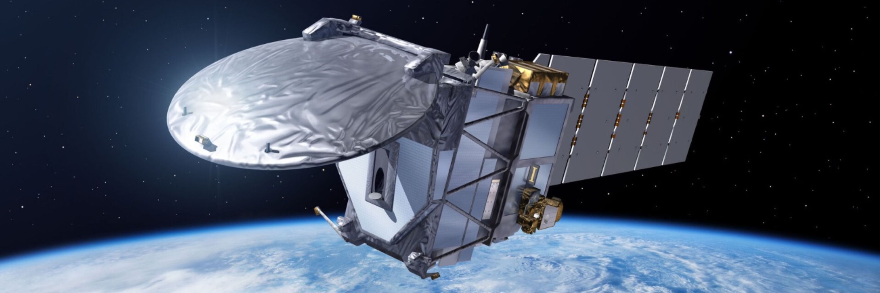
Principal Scientist at #ECMWF and Professor of Atmospheric Physics at the University of Reading - Radiative Transfer - Co-Chair of ESA-JAXA #EarthCARE Mission Advisory Group

Environmental science 52%
Geography 19%

Nice paper, thanks! ECMWF web article coming soon comparing our observations of Humberto with simulations by the IFS at high resolution.

There are some tools listed at the page below. This image was produced by Shannon Mason using his free ectools package but I would like these to be produced routinely for all EarthCARE frames. www.earthcarescience.net/tools
EarthCARE Science - Tools
Online visualization
www.earthcarescience.net

Would you believe it: just 10 days after #EarthCARE went through the eye of Hurricane Humberto, it did the same with Hurricane Priscilla in the East Pacific on 7 October! A very different beast this one: a huge eye around 100 km across, and very lopsided, with much more rain on the southern side.

Second, the signal from the "Rayleigh" channel of EarthCARE's lidar is strongly related with ocean chlorophyll estimates from routine ocean colour measurements, with the advantage that EarthCARE's lidar can continue to make measurements in polar night!

First, the depolarisation of the land surface measured by EarthCARE's lidar seems to be very well correlated to the widely used "NDVI" vegetation index - but why? We don't yet know but potentially this could be telling us something new about vegetation!

New instruments always throw up surprises - Gerd-Jan van Zadelhoff of KNMI had a look at the #EarthCARE lidar's surface returns and found some intriguing and unexpected things as explained in ESA's latest EarthCARE web story... earth.esa.int/eogateway/su...

And here's EarthCARE's radar reflectivity with GOES-E for context (thanks to Mark Fielding)!

The level of detail revealed by EarthCARE is amazing: as well as the usual change in vertical Doppler velocity as snow melts to rain, we can see the rising air in the eye wall! The imager also captures the 3D nature of the convective cells in the rain bands further out. More analysis to come...
So this is pretty amazing - yesterday EarthCARE sampled Hurricane Humberto straight across the eye! The eye of a tropical cyclone is small so a direct hit is rare: this is the first time EarthCARE has hit one after over a year in orbit! (Showing here also VIIRS on NOAA-20 for context.)

...and the volcanic plume from Klyuchevskaya Sopka in Russia, which erupted July-August 2025. More coming soon! Thanks as always to @masonshannon.bsky.social for many of the images and to NASA Worldview for the wider context. worldview.earthdata.nasa.gov?v=154.961959...

EarthCARE is a inexhaustible source of beautiful imagery of some of the most spectacular phenomena nature has to offer, so I've started a Gallery page on the EarthCARE Science web site, showing for example convective motions in the trainbands of Typhoon Ragasa... www.earthcarescience.net/gallery

Reposted by Johannes Quaas

It's official: WIVERN will be ESA's 11th Earth Explorer satellite, measuring winds deep inside hurricanes, fronts and other weather systems!
www.esa.int/Applications...
ESA selects WIVERN as 11th Earth Explorer mission
After meticulous preparation and rigorous evaluation, ESA’s Member States have selected WIVERN to become the 11th Earth Explorer mission to be implemented through the agency’s prestigious FutureEO pro...
www.esa.int

This is the first time this process has been observed from space, thanks to EarthCARE's Doppler radar and high-spectral-resolution lidar! But how common is it globally and do these optically thick clouds have an impact on precipitation or even climate? Only EarthCARE can answer these questions!

When we look at the cloud properties estimated by combining the radar, lidar and imager (using the "ACM-CAP" algorithm developed by @masonshannon.bsky.social and me) we see this layer contains high concentrations of very small ice crystals. The imager shows that they block upward thermal radiation.

These are atmospheric gravity waves with a wavelength of 18 km, probably triggered by airflow over mountains; wavy structures are also seen in the zoomed-in radar and lidar backscatter. The updrafts bring air to liquid saturation and droplets form, but colder than -40°C they immediately freeze.

Another great #EarthCARE Image of the Month, this time led by Shannon Mason (@masonshannon.bsky.social): the Doppler radar sees wave structures in an Antarctic cloud while the lidar and imager see an optically thick ice cloud layer at around -45°C. What's going on? earth.esa.int/eogateway/su...

Good science explains unexpected observations, but great science predicts things only later confirmed from observations. Brilliant article from Nadir Jeevanjee on the fundamental correctness of climate models and the incredible work of Syukuro Manabe. theconversation.com/5-forecasts-...
5 forecasts early climate models got right – the evidence is all around you
From rising global temperatures to the fast-warming Arctic, early climate models predicted the changes half a century ago.
theconversation.com

Great to see the new #ECMWF building going up on the beautiful University of Reading campus, very near the Meteorology Department - looking forward to moving in in 2027!

The deadline for abstracts to December's #EarthCARE Science & Validation workshop in Tokyo has been extended to 1st September. www.eorc.jaxa.jp/EARTHCARE/ev...

ESA has performed careful calculations of projected fuel usage in the case of weak, moderate and strong solar activity - if the next solar maximum is weak, EarthCARE would have fuel for much longer than 10 years! Let's hope the instruments keep operating as successfully as they have so far...🤞

The next #EarthCARE Science and Validation Workshop is in Tokyo this December - the deadline for abstract submission is 20 August. It will be a great opportunity to share our scientific findings so far and will coincide with the release of final tranche of products. www.eorc.jaxa.jp/EARTHCARE/ev...

Congratulations to the WIVERN team for all their amazing work in preparing the case for selection, particularly to Professor Anthony Illingworth who had the original idea for WIVERN, as well as being the Father of EarthCARE!

You can learn more from the WIVERN presentations given at the user consultation meeting in Prague last week - I particularly liked the animations showing what WIVERN will measure in tropical cyclones! www.youtube.com/watch?v=5tfX...

Great news: "WIVERN" has been recommended as ESA's 11th Earth Explorer satellite following the user consultation meeting last week! WIVERN uses a scanning 94-GHz radar to measure winds and reflectivity in an 800 km swath, invaluable for assimilation and understanding severe weather. wivern.polito.it

You can find all #EarthCARE web stories listed at the EarthCARE Science web site: www.earthcarescience.net/web-stories

Beautiful high-resolution imagery from #EarthCARE's multi-spectral imager in a Category 4 tropical cyclone! earth.esa.int/eogateway/su...
EarthCARE stares into the eye of Tropical Cyclone Vince - Earth Online
A rare glimpse into the eye of Tropical Cyclone Vince, thanks to EarthCARE’s multispectral imager, gave us a crisp picture of the fine-scale structures in and around the eye wall and recorded some rem...
earth.esa.int

Taking #EarthCARE merch to the next level! You've got the polo shirt. You've even got the lego model. Now you can enjoy EarthCARE toilet paper! 🧻🧻🧻 Rated top for environmental impact by Consumer NZ 👍 www.stuff.co.nz/business/121...

Huge amounts of Arctic smoke from Canadian wildfires seen by #EarthCARE's lidar: it is being transported over the North Pole to Europe and has even entered the stratosphere! earth.esa.int/eogateway/su...
EarthCARE sees Canadian wildfire smoke spreading over the Northern Hemisphere - Earth Online
Canada is facing an extreme wildfire season in 2025. By 12 June, the Canadian government had reported 225 wildfires in British Columbia, Alberta, Saskatchewan, Manitoba, and Ontario. Over 3.7 million ...
earth.esa.int