

Senior researcher at IMAGINE (ENPC, LIGM).
Machine learning & computer vision for 3D + geospatial + historical data.
loiclandrieu.com
Reposted by Loïc Landrieu


A new large-scale, multimodal dataset for land cover and crop type mapping
🤗 Dataset: huggingface.co/datasets/IGN...
📄 Preprint: arxiv.org/abs/2506.07080
🤗 Pretrained models: huggingface.co/collections/...
💻 Code: github.com/IGNF/FLAIR-HUB
🌐 Project : arxiv.org/abs/2506.07080
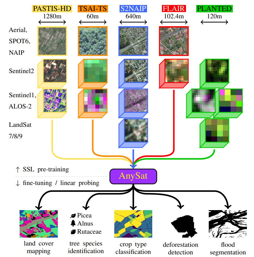
🛰️ AnySat: One Earth Observation Model for Many Resolutions, Scales, and Modalities
@gastruc.bsky.social @nicaogr.bsky.social @loicland.bsky.social
📄 pdf: arxiv.org/abs/2412.14123
🌐 webpage: gastruc.github.io/anysat
Reposted by Loïc Landrieu
🛰️ AnySat: One Earth Observation Model for Many Resolutions, Scales, and Modalities
@gastruc.bsky.social @nicaogr.bsky.social @loicland.bsky.social
📄 pdf: arxiv.org/abs/2412.14123
🌐 webpage: gastruc.github.io/anysat
Reposted by Loïc Landrieu
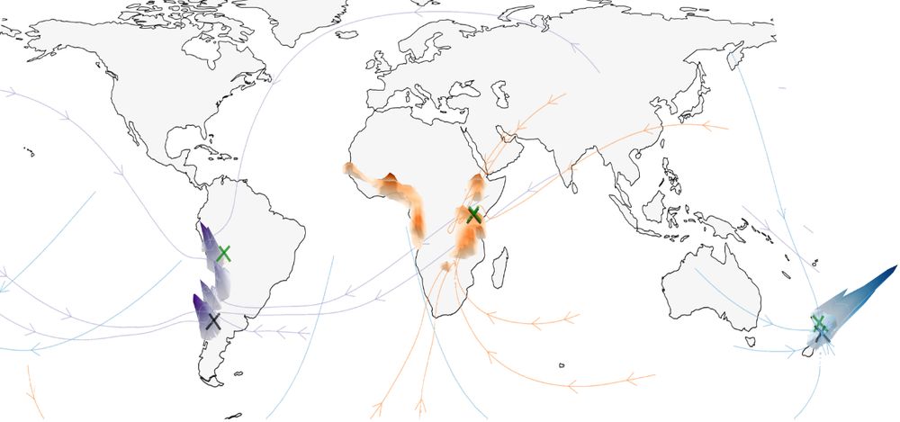
🌍 Around the World in 80 Timesteps: A Generative Approach to Global Visual Geolocation
@nicolasdufour.bsky.social @vickykalogeiton.bsky.social @davidpicard.bsky.social @loicland.bsky.social
📄 pdf: arxiv.org/abs/2412.06781
🌐 webpage: nicolas-dufour.github.io/plonk.html
Reposted by Serge Belongie, Loïc Landrieu
– competitive salary
– no teaching load
– starting pkg ≈ 2 PhDs
– goal: impactful core AI + X (climate, biodiversity, robotics...)
Apply by May 31: imagine-lab.enpc.fr/wp-content/u...
Reposted by Loïc Landrieu
🌍💿 TerraBytes: Towards global datasets and models for Earth Observation
Co-located with ICML 2025 (Vancouver, Canada)
🔗 terrabytes-workshop.github.io
📝 We accept short 4-pages and full 8-pages paper on remote sensing, Earth Observation and machine learning.
📆 Deadline: May 16th
Registration is open (it's free) with priority given to authors of accepted papers: cvprinparis.github.io/CVPR2025InPa...
Big 🧵👇 with details!


Reposted by Czech Republic, Loïc Landrieu

Registration is open (it's free) with priority given to authors of accepted papers: cvprinparis.github.io/CVPR2025InPa...
Big 🧵👇 with details!
Reposted by Loïc Landrieu
Feel free to contact me in DM.
*ENPC, part of Institut Polytechnique de Paris
Introducing AnySat: one model for any resolution (0.2m–250m), scale (0.3–2600 hectares), and modalities (choose from 11 sensors & time series)!
Try it with just a few lines of code:

Reposted by Loïc Landrieu

Introducing AnySat: one model for any resolution (0.2m–250m), scale (0.3–2600 hectares), and modalities (choose from 11 sensors & time series)!
Try it with just a few lines of code:
🗺️ Paper, code, and demo: nicolas-dufour.github.io/plonk
🔗 huggingface.co/spaces/nicol...
Reposted by Czech Republic, Loïc Landrieu

🗺️ Paper, code, and demo: nicolas-dufour.github.io/plonk
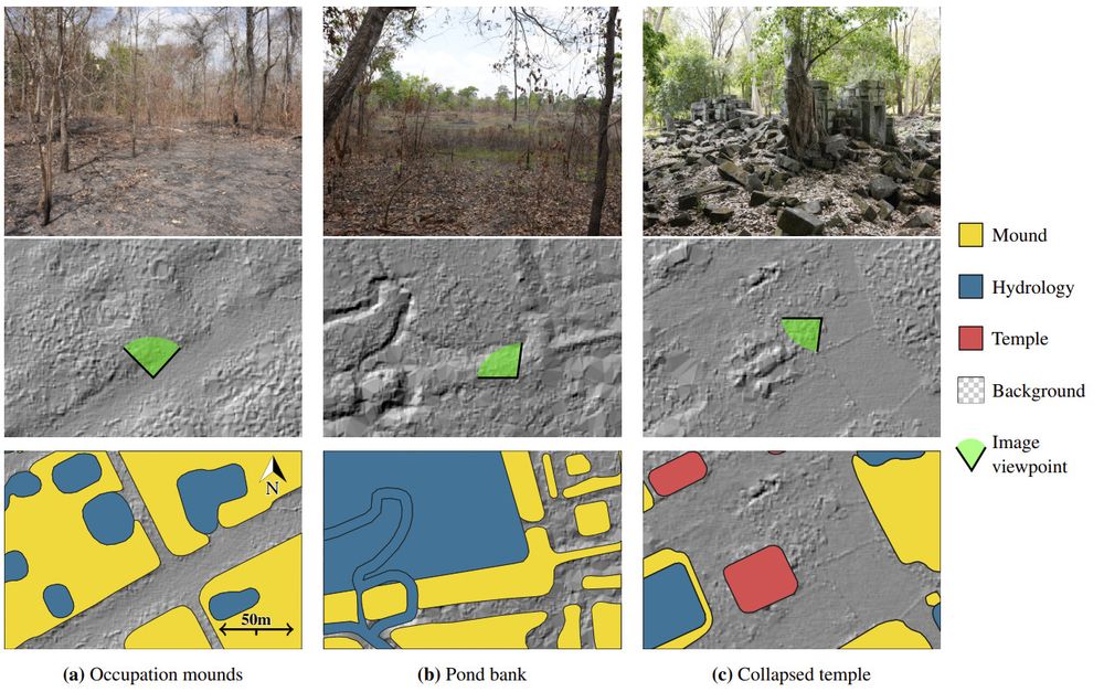
🖼️ Poster: 5302 | 12/12 | 11 AM
📜 Paper: openreview.net/pdf?id=QpF3D...
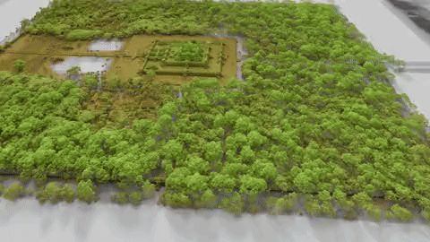
🌐 Web & Data: archaeoscape.ai/data/2024
🤝 Joint Work: ENPC + French School of Asian Studies (#EFEO)
Reposted by Loïc Landrieu
We got this idea after their cool work on improving Plug and Play with FM: arxiv.org/abs/2410.02423