


Colockum Wildlife Area from Babcock Bench, Central WA
#hike #shrubsteppe #columbiariver #desert #missoulafloods
#hike #shrubsteppe #columbiariver #desert #missoulafloods

January 3, 2026 at 1:35 PM
Colockum Wildlife Area from Babcock Bench, Central WA
#hike #shrubsteppe #columbiariver #desert #missoulafloods
#hike #shrubsteppe #columbiariver #desert #missoulafloods

July 26, 2025 at 2:21 PM
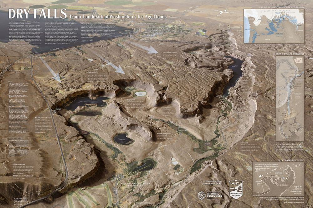
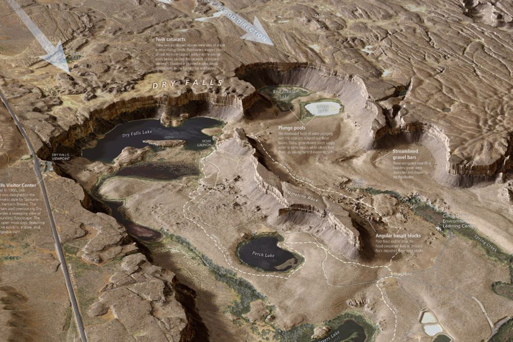
New, super-detailed Dry Falls interpretive map from the Washington Geological Survey. #iceagefloods #missoulafloods #channeledscablands #geomorphology washingtonstategeology.wordpress.com/2025/07/15/n...
July 23, 2025 at 4:26 AM
New, super-detailed Dry Falls interpretive map from the Washington Geological Survey. #iceagefloods #missoulafloods #channeledscablands #geomorphology washingtonstategeology.wordpress.com/2025/07/15/n...
@joelgombiner.bsky.social and I had a conversation with Nick Zentner yesterday about our upcoming WGS #DryFalls map. Looking for feedback before publishing. #iceagefloods #missoulafloods #geomorphology youtu.be/v01cycrCgno

Daniel Coe & Joel Gombiner - Washington Geological Survey
YouTube video by Nick Zentner
youtu.be
May 29, 2025 at 4:15 PM
@joelgombiner.bsky.social and I had a conversation with Nick Zentner yesterday about our upcoming WGS #DryFalls map. Looking for feedback before publishing. #iceagefloods #missoulafloods #geomorphology youtu.be/v01cycrCgno


April 3, 2025 at 3:39 AM

March 31, 2025 at 3:53 AM

Crawford Oaks State Park view
#Oregon #OR #washingtonstate #WA #columbiariver #columbiarivergorge #thedalles #hiking #missoulafloods #Portland #portlandoregon #pdx #sony #sony55210 #photography #landscapephotography
#Oregon #OR #washingtonstate #WA #columbiariver #columbiarivergorge #thedalles #hiking #missoulafloods #Portland #portlandoregon #pdx #sony #sony55210 #photography #landscapephotography

March 2, 2025 at 3:28 AM
Crawford Oaks State Park view
#Oregon #OR #washingtonstate #WA #columbiariver #columbiarivergorge #thedalles #hiking #missoulafloods #Portland #portlandoregon #pdx #sony #sony55210 #photography #landscapephotography
#Oregon #OR #washingtonstate #WA #columbiariver #columbiarivergorge #thedalles #hiking #missoulafloods #Portland #portlandoregon #pdx #sony #sony55210 #photography #landscapephotography
I can't wait for Nick Zentner to move over to BlueSky because his stuff is about all that's worth checking the old site for anymore. I'll never see this wall along the Columbia Gorge at Vantage the same.
#geology #missoulafloods #basalt #floodlava #washington #vantage
#geology #missoulafloods #basalt #floodlava #washington #vantage

December 13, 2024 at 7:49 PM
I can't wait for Nick Zentner to move over to BlueSky because his stuff is about all that's worth checking the old site for anymore. I'll never see this wall along the Columbia Gorge at Vantage the same.
#geology #missoulafloods #basalt #floodlava #washington #vantage
#geology #missoulafloods #basalt #floodlava #washington #vantage