


Sunday morning update. This speedy system will slow before it makes its final exit = a touch more snow for Boston & south/southwest. Updated map below with light, steady snow wrapping up Sunday afternoon. Pats game will see 🌨️❄️
#mawx #riwx #ctwx #patriots #boston #snow @bostonglobe.com
#mawx #riwx #ctwx #patriots #boston #snow @bostonglobe.com

December 14, 2025 at 2:23 PM


December 14, 2025 at 2:05 PM


December 14, 2025 at 2:04 PM

SKYWARN Self-Activation monitoring for snowfall reports from the Sunday 12/14/25 Accumulating Snow/Winter Storm Event. Latest update here: wx1box.org/2025/12/14/s... #mawx #riwx #ctwx
Storm Coordination Message #2 – Sunday 12/14/25 – Accumulating Snow Event
wx1box.org
December 14, 2025 at 12:10 PM
SKYWARN Self-Activation monitoring for snowfall reports from the Sunday 12/14/25 Accumulating Snow/Winter Storm Event. Latest update here: wx1box.org/2025/12/14/s... #mawx #riwx #ctwx


SKYWARN Self-Activation with monitoring of Amateur Radio Repeaters in Rhode Island and Southeast Massachusetts for accumulating snow potential late Saturday Night into Sunday Evening. See wx1box.org/2025/12/13/s... for info. #mawx #riwx #ctwx
Storm Coordination Message #1 – Late Saturday Evening 12/13/25-Sunday 12/14/25 Accumulating Snow Potential
wx1box.org
December 13, 2025 at 5:16 PM
SKYWARN Self-Activation with monitoring of Amateur Radio Repeaters in Rhode Island and Southeast Massachusetts for accumulating snow potential late Saturday Night into Sunday Evening. See wx1box.org/2025/12/13/s... for info. #mawx #riwx #ctwx

A quick hit of snow this weekend will be followed by yet another Arctic Blast for New England early next week. Milder air is on the way by midweek next week. Details: #MAwx #CTwx #RIwx #NHwx #MEwx #VTwx
www.newenglandstormcenter.com/post/quick-h...
www.newenglandstormcenter.com/post/quick-h...

Quick Hit of Snow to be Followed by Another Arctic Blast for New England
A strong northern stream system will pass to the north of New England later Saturday into Sunday. This system will generally not phase with a southern stream system passing south of New England. This ...
www.newenglandstormcenter.com
December 13, 2025 at 1:23 PM
New snow totals, a touch more for R.I. & the Berkshires. Boston is still holding on to about an inch or so. Storm sped up a little overnight, SO arrival is now late Saturday and expected to last through at least midday Sunday.
#mawx #nhwx #riwx #ctwx #boston #newengland @bostonglobe.com
#mawx #nhwx #riwx #ctwx #boston #newengland @bostonglobe.com


December 13, 2025 at 12:39 PM
New snow totals, a touch more for R.I. & the Berkshires. Boston is still holding on to about an inch or so. Storm sped up a little overnight, SO arrival is now late Saturday and expected to last through at least midday Sunday.
#mawx #nhwx #riwx #ctwx #boston #newengland @bostonglobe.com
#mawx #nhwx #riwx #ctwx #boston #newengland @bostonglobe.com

I was supposed to post this verification from Providence #RIWX, but didn't! Too bad, because things worked out well #Victoria_weather victoria-weather.com/2025/12/12/i...

I can’t believe I missed this
I verified Raleigh earlier this week, and completely skipped over the verification for Providence. This was a busy forecast, with some rain coming into the area just as Thanksgiving was drawing nea…
victoria-weather.com
December 13, 2025 at 3:35 AM
I was supposed to post this verification from Providence #RIWX, but didn't! Too bad, because things worked out well #Victoria_weather victoria-weather.com/2025/12/12/i...
It looks like a glancing blow is in store for New England from this weekend's storm. There's still a decent range from the southernmost to northernmost solutions, but a couple inches of snow looks likely for southernmost areas. Main ? will be the northern extent. #MAwx #CTwx #RIwx #NHwx #MEwx #VTwx


December 12, 2025 at 11:29 PM
Update: Still some accumulating snow likely for Boston on Sunday. Timing: Early Sunday am to early afternoon. Up to 3" by the Cape. Still some variation in the forecast ahead of time. Pats vs. Bills might see snow!
www.bostonglobe.com/2025/12/11/m...
#mawx #riwx #patriots #boston @bostonglobe.com
www.bostonglobe.com/2025/12/11/m...
#mawx #riwx #patriots #boston @bostonglobe.com

December 12, 2025 at 9:48 PM
Update: Still some accumulating snow likely for Boston on Sunday. Timing: Early Sunday am to early afternoon. Up to 3" by the Cape. Still some variation in the forecast ahead of time. Pats vs. Bills might see snow!
www.bostonglobe.com/2025/12/11/m...
#mawx #riwx #patriots #boston @bostonglobe.com
www.bostonglobe.com/2025/12/11/m...
#mawx #riwx #patriots #boston @bostonglobe.com
Sunday light snow chances are increasing! Early morning through mid-afternoon. #Patriots vs #Bills in the cold AND snow!? Big game. Pats are 4-4 against the Bills at home with the same weather conditions.
#mawx #riwx #ctwx #newengland @bostonglobe.com @patriots.bsky.social
#mawx #riwx #ctwx #newengland @bostonglobe.com @patriots.bsky.social


December 12, 2025 at 5:53 PM
Sunday light snow chances are increasing! Early morning through mid-afternoon. #Patriots vs #Bills in the cold AND snow!? Big game. Pats are 4-4 against the Bills at home with the same weather conditions.
#mawx #riwx #ctwx #newengland @bostonglobe.com @patriots.bsky.social
#mawx #riwx #ctwx #newengland @bostonglobe.com @patriots.bsky.social
A storm system passing well to the south of New England is poised to bring a glancing blow of snow to New England, with a couple inches likely for southern areas. Details: #MAwx #CTwx #RIwx #NHwx #MEwx #VTwx
www.newenglandstormcenter.com/post/weekend...
www.newenglandstormcenter.com/post/weekend...

Weekend Storm Likely Brings a Glancing Blow to New England
After a week of watching a potential coastal storm wobbling around southern New England, the flip-flopping between scenarios is settling down. Guidance is honing in on an "in-between" scenario, with a...
www.newenglandstormcenter.com
December 12, 2025 at 2:00 PM
This weekend's storm is favoring a glancing blow for New England. The coastal system will likely strengthen a bit too late to bring a full snowstorm, but a period of accumulating snow remains possible for southernmost areas. A jog to the north still can't be ruled out. #MAwx #CTwx #RIwx #NHwx #MEwx

December 11, 2025 at 11:51 PM


Cold air is once again spilling into New England behind a cold front. This weekend's storm is currently looking more like a glancing blow for southernmost New England and Downeast Maine, but questions remain. Details: #MAwx #CTwx #RIwx #NHwx #MEwx #VTwx
www.newenglandstormcenter.com/post/watchin...
www.newenglandstormcenter.com/post/watchin...

Watching This Weekend's Storm Track Near New England
New England's most recent Alberta Clipper system is now moving away. This has dragged a rather strong cold front across the region overnight. A secondary front will be working through New England this...
www.newenglandstormcenter.com
December 11, 2025 at 1:17 PM
SKYWARN Self-Activation to monitor strong to damaging wind potential late Thursday Morning through late Friday Morning. Wind Advisory expanded to cover the entire NWS Norton MA Coverage Area. See wx1box.org/2025/12/11/w... for info. #mawx #riwx #ctwx
Wind Coordination Message #2 – Thursday AM 12/11/25-Friday AM 12/12/25 – Strong to Damaging Wind Potential
wx1box.org
December 11, 2025 at 1:05 PM
SKYWARN Self-Activation to monitor strong to damaging wind potential late Thursday Morning through late Friday Morning. Wind Advisory expanded to cover the entire NWS Norton MA Coverage Area. See wx1box.org/2025/12/11/w... for info. #mawx #riwx #ctwx
SKYWARN Self-Activation will monitor strong to damaging wind potential Thursday AM to Friday AM across Southern New England. See wx1box.org/2025/12/11/w... for info. #mawx #riwx #ctwx
Wind Coordination Message #1 – Thursday AM 12/11/25-Friday AM 12/12/25 Strong to Damaging Wind Potential
wx1box.org
December 11, 2025 at 4:23 AM
SKYWARN Self-Activation will monitor strong to damaging wind potential Thursday AM to Friday AM across Southern New England. See wx1box.org/2025/12/11/w... for info. #mawx #riwx #ctwx
A clipper continues to work across New England this evening, bringing with it a widespread 3-6" of snow to the north and mountains. Cold air advection kicks off behind the system's cold front tomorrow, with temps. dropping through the day. #MAwx #CTwx #RIwx #NHwx #MEwx #VTwx
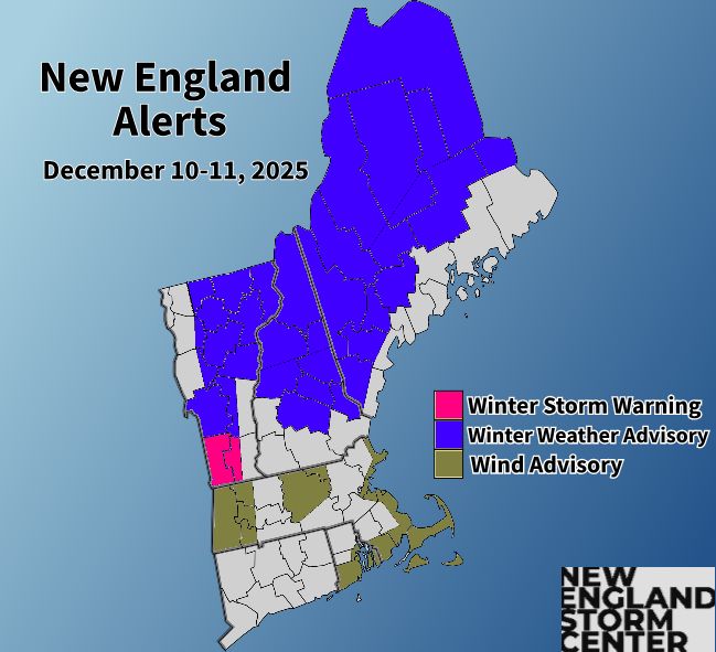

December 10, 2025 at 11:20 PM
A thump of snow is in store for northern New England today. This will followed by a return of colder air. The next system will pass New England this weekend, but major questions remain on its potential impact. Details: #MAwx #CTwx #RIwx #NHwx #MEwx #VTwx
www.newenglandstormcenter.com/post/thump-o...
www.newenglandstormcenter.com/post/thump-o...

Thump of Snow Today for Northern New England; Watching This Weekend
Precipitation chances will increase from west to east beginning this morning in the mid to late morning hours. This will steadily spread east through the afternoon hours. Precipitation will reach nort...
www.newenglandstormcenter.com
December 10, 2025 at 1:07 PM
Next storm for New England will bring snow to the interior and rain to more coastal areas. Jackpot of 3-6" is most likely across the northern tier. Mountains will likely see more. Next system arrives this weekend, with plenty of outcomes still on the table. #MAwx #CTwx #RIwx #NHwx #MEwx #VTwx


December 9, 2025 at 11:45 PM
Mild & messy Wednesday across #NewEngland. Rain for #Boston & snow west/north. Not a big storm, since it's a quick-mover. Jackpot totals up north 3-6". Wintry mix before turning to rain for areas like Worcester, Manchester, N.H., Springfield.
#mawx #nhwx #riwx @bostonglobe.com
#mawx #nhwx #riwx @bostonglobe.com


December 9, 2025 at 5:35 PM
Mild & messy Wednesday across #NewEngland. Rain for #Boston & snow west/north. Not a big storm, since it's a quick-mover. Jackpot totals up north 3-6". Wintry mix before turning to rain for areas like Worcester, Manchester, N.H., Springfield.
#mawx #nhwx #riwx @bostonglobe.com
#mawx #nhwx #riwx @bostonglobe.com
Cold case: Watch our next round of Arctic air shoot out of Alaska, reaching New England by the end of this weekend. Temps once again 30° below average, challenging overnight daily lows.
#mawx #riwx #nhwx #newengland #winter #polarvortex @bostonglobe.com
#mawx #riwx #nhwx #newengland #winter #polarvortex @bostonglobe.com
December 9, 2025 at 1:24 PM
Cold case: Watch our next round of Arctic air shoot out of Alaska, reaching New England by the end of this weekend. Temps once again 30° below average, challenging overnight daily lows.
#mawx #riwx #nhwx #newengland #winter #polarvortex @bostonglobe.com
#mawx #riwx #nhwx #newengland #winter #polarvortex @bostonglobe.com
New England's fast-moving pattern continues with a very quick hit of snow showers tonight followed by a more organized system for Wednesday. This system will bring a few inches of snow inland. Details: #MAwx #CTwx #RIwx #NHwx #MEwx #VTwx
www.newenglandstormcenter.com/post/quick-h...
www.newenglandstormcenter.com/post/quick-h...

Quick Hits of Snow/Rain Incoming to New England
Throughout the day today, high pressure will shift from being directly overhead to the east of New England. This will set up a weak southerly flow and warm air advection. The overall air mass remains ...
www.newenglandstormcenter.com
December 9, 2025 at 1:17 PM