


Grass Fire Back Walbundrie Rand Rd, Walbundrie 2642
Status: Under Control
Size: 0 ha
7 Dec 2025, 9:33 am
From #NSW/RFS
Find on Map >
#EMVAlert #incident #Fire #GrassFire
Status: Under Control
Size: 0 ha
7 Dec 2025, 9:33 am
From #NSW/RFS
Find on Map >
#EMVAlert #incident #Fire #GrassFire
December 6, 2025 at 10:38 PM
Grass Fire Back Walbundrie Rand Rd, Walbundrie 2642
Status: Under Control
Size: 0 ha
7 Dec 2025, 9:33 am
From #NSW/RFS
Find on Map >
#EMVAlert #incident #Fire #GrassFire
Status: Under Control
Size: 0 ha
7 Dec 2025, 9:33 am
From #NSW/RFS
Find on Map >
#EMVAlert #incident #Fire #GrassFire
Grass Fire Culcairn Holbrook Rd, Morven 2660
Status: Under Control
Size: 0 ha
7 Dec 2025, 7:09 am
From #NSW/RFS
Find on Map >
#EMVAlert #incident #Fire #GrassFire
Status: Under Control
Size: 0 ha
7 Dec 2025, 7:09 am
From #NSW/RFS
Find on Map >
#EMVAlert #incident #Fire #GrassFire
December 6, 2025 at 8:14 PM
Grass Fire Culcairn Holbrook Rd, Morven 2660
Status: Under Control
Size: 0 ha
7 Dec 2025, 7:09 am
From #NSW/RFS
Find on Map >
#EMVAlert #incident #Fire #GrassFire
Status: Under Control
Size: 0 ha
7 Dec 2025, 7:09 am
From #NSW/RFS
Find on Map >
#EMVAlert #incident #Fire #GrassFire
Grass Fire Back Walbundrie Rand Rd, Walbundrie 2642
Status: Under Control
Size: 0 ha
5 Dec 2025, 6:48 pm
From #NSW/RFS
Find on Map >
#EMVAlert #incident #Fire #GrassFire
Status: Under Control
Size: 0 ha
5 Dec 2025, 6:48 pm
From #NSW/RFS
Find on Map >
#EMVAlert #incident #Fire #GrassFire
December 5, 2025 at 7:50 AM
Grass Fire Back Walbundrie Rand Rd, Walbundrie 2642
Status: Under Control
Size: 0 ha
5 Dec 2025, 6:48 pm
From #NSW/RFS
Find on Map >
#EMVAlert #incident #Fire #GrassFire
Status: Under Control
Size: 0 ha
5 Dec 2025, 6:48 pm
From #NSW/RFS
Find on Map >
#EMVAlert #incident #Fire #GrassFire

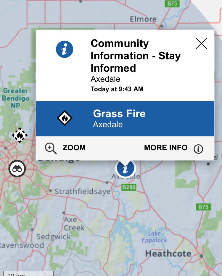
Victoria Watch and Act Grass Fire
15:53
Browns Plains Rooredeane Rd
Fire is travelling SE from Rooredeane Road, Browns Plains towards Barnawartha North
15:53
Browns Plains Rooredeane Rd
Fire is travelling SE from Rooredeane Road, Browns Plains towards Barnawartha North

December 5, 2025 at 5:46 AM
Victoria Watch and Act Grass Fire
15:53
Browns Plains Rooredeane Rd
Fire is travelling SE from Rooredeane Road, Browns Plains towards Barnawartha North
15:53
Browns Plains Rooredeane Rd
Fire is travelling SE from Rooredeane Road, Browns Plains towards Barnawartha North
Victoria Watch and Act Grass Fire
16:32
The Logic Center - Barnawartha North
There is a grassfire at Rooredeane Rd, Browns Plains that is not yet under control
Fire is travelling in a southeasterly direction from Rooredeane Road, Browns Plains towards The Logic Centre - Barnawartha North
16:32
The Logic Center - Barnawartha North
There is a grassfire at Rooredeane Rd, Browns Plains that is not yet under control
Fire is travelling in a southeasterly direction from Rooredeane Road, Browns Plains towards The Logic Centre - Barnawartha North

December 5, 2025 at 5:43 AM
Victoria Watch and Act Grass Fire
16:32
The Logic Center - Barnawartha North
There is a grassfire at Rooredeane Rd, Browns Plains that is not yet under control
Fire is travelling in a southeasterly direction from Rooredeane Road, Browns Plains towards The Logic Centre - Barnawartha North
16:32
The Logic Center - Barnawartha North
There is a grassfire at Rooredeane Rd, Browns Plains that is not yet under control
Fire is travelling in a southeasterly direction from Rooredeane Road, Browns Plains towards The Logic Centre - Barnawartha North

If you see this, repost with your model of positive masculinity.
December 5, 2025 at 3:43 AM
If you see this, repost with your model of positive masculinity.
First warm one for a while today - kicking off three days of heat in the Bendigo region. We got our first grassfire and it’s not even 10am.
Happy summer everyone. 😑
Happy summer everyone. 😑
December 2, 2025 at 10:50 PM
First warm one for a while today - kicking off three days of heat in the Bendigo region. We got our first grassfire and it’s not even 10am.
Happy summer everyone. 😑
Happy summer everyone. 😑
Grass Fire Newell Hwy, Tocumwal 2714
Status: Responding
Size: 0 ha
1 Dec 2025, 10:48 am
From #NSW/RFS
Find on Map >
#EMVAlert #incident #Fire #GrassFire
Status: Responding
Size: 0 ha
1 Dec 2025, 10:48 am
From #NSW/RFS
Find on Map >
#EMVAlert #incident #Fire #GrassFire
November 30, 2025 at 11:51 PM
Grass Fire Newell Hwy, Tocumwal 2714
Status: Responding
Size: 0 ha
1 Dec 2025, 10:48 am
From #NSW/RFS
Find on Map >
#EMVAlert #incident #Fire #GrassFire
Status: Responding
Size: 0 ha
1 Dec 2025, 10:48 am
From #NSW/RFS
Find on Map >
#EMVAlert #incident #Fire #GrassFire
Grass Fire 86 Pelican Lane, Table Top 2640
Status: Under Control
Size: 15 ha
1 Dec 2025, 7:45 am
From #NSW/RFS
Find on Map >
#EMVAlert #incident #Fire #GrassFire
Status: Under Control
Size: 15 ha
1 Dec 2025, 7:45 am
From #NSW/RFS
Find on Map >
#EMVAlert #incident #Fire #GrassFire
November 30, 2025 at 8:47 PM
Grass Fire 86 Pelican Lane, Table Top 2640
Status: Under Control
Size: 15 ha
1 Dec 2025, 7:45 am
From #NSW/RFS
Find on Map >
#EMVAlert #incident #Fire #GrassFire
Status: Under Control
Size: 15 ha
1 Dec 2025, 7:45 am
From #NSW/RFS
Find on Map >
#EMVAlert #incident #Fire #GrassFire
Grass Fire 86 Pelican Lane, Table Top 2640
Status: Under Control
Size: 15 ha
29 Nov 2025, 6:04 pm
From #NSW/RFS
Find on Map >
#EMVAlert #incident #Fire #GrassFire
Status: Under Control
Size: 15 ha
29 Nov 2025, 6:04 pm
From #NSW/RFS
Find on Map >
#EMVAlert #incident #Fire #GrassFire
November 29, 2025 at 7:07 AM
Grass Fire 86 Pelican Lane, Table Top 2640
Status: Under Control
Size: 15 ha
29 Nov 2025, 6:04 pm
From #NSW/RFS
Find on Map >
#EMVAlert #incident #Fire #GrassFire
Status: Under Control
Size: 15 ha
29 Nov 2025, 6:04 pm
From #NSW/RFS
Find on Map >
#EMVAlert #incident #Fire #GrassFire
Grass Fire 86 Pelican Lane, Table Top 2640
Status: Under Control
Size: 15 ha
27 Nov 2025, 9:05 pm
From #NSW/RFS
Find on Map >
#EMVAlert #incident #Fire #GrassFire
Status: Under Control
Size: 15 ha
27 Nov 2025, 9:05 pm
From #NSW/RFS
Find on Map >
#EMVAlert #incident #Fire #GrassFire
November 27, 2025 at 10:11 AM
Grass Fire 86 Pelican Lane, Table Top 2640
Status: Under Control
Size: 15 ha
27 Nov 2025, 9:05 pm
From #NSW/RFS
Find on Map >
#EMVAlert #incident #Fire #GrassFire
Status: Under Control
Size: 15 ha
27 Nov 2025, 9:05 pm
From #NSW/RFS
Find on Map >
#EMVAlert #incident #Fire #GrassFire
Grass Fire Hudsons Rd, Corowa 2646
Status: Under Control
Size: 541 ha
27 Nov 2025, 10:47 am
From #NSW/RFS
Find on Map >
#EMVAlert #incident #Fire #GrassFire
Status: Under Control
Size: 541 ha
27 Nov 2025, 10:47 am
From #NSW/RFS
Find on Map >
#EMVAlert #incident #Fire #GrassFire
November 26, 2025 at 11:51 PM
Grass Fire Hudsons Rd, Corowa 2646
Status: Under Control
Size: 541 ha
27 Nov 2025, 10:47 am
From #NSW/RFS
Find on Map >
#EMVAlert #incident #Fire #GrassFire
Status: Under Control
Size: 541 ha
27 Nov 2025, 10:47 am
From #NSW/RFS
Find on Map >
#EMVAlert #incident #Fire #GrassFire
Grass Fire Iluka Cr, Lavington, Nsw 2641
Status: Under Control
Size: 0 ha
26 Nov 2025, 5:50 pm
From #NSW/RFS
Find on Map >
#EMVAlert #incident #Fire #GrassFire
Status: Under Control
Size: 0 ha
26 Nov 2025, 5:50 pm
From #NSW/RFS
Find on Map >
#EMVAlert #incident #Fire #GrassFire
November 26, 2025 at 6:51 AM
Grass Fire Iluka Cr, Lavington, Nsw 2641
Status: Under Control
Size: 0 ha
26 Nov 2025, 5:50 pm
From #NSW/RFS
Find on Map >
#EMVAlert #incident #Fire #GrassFire
Status: Under Control
Size: 0 ha
26 Nov 2025, 5:50 pm
From #NSW/RFS
Find on Map >
#EMVAlert #incident #Fire #GrassFire
NSW Emergency Warning Grassfire
Hudsons Rd Fire
Corowa
A fire is burning in the the vicinity of Whitehead St, Corowa. If you are north of Corowa, in the area north of Redlands Rd and west of Honour Ave, you are in danger
Seek shelter now, or as the fire approaches
It is too late to leave
Hudsons Rd Fire
Corowa
A fire is burning in the the vicinity of Whitehead St, Corowa. If you are north of Corowa, in the area north of Redlands Rd and west of Honour Ave, you are in danger
Seek shelter now, or as the fire approaches
It is too late to leave

November 26, 2025 at 4:50 AM
NSW Emergency Warning Grassfire
Hudsons Rd Fire
Corowa
A fire is burning in the the vicinity of Whitehead St, Corowa. If you are north of Corowa, in the area north of Redlands Rd and west of Honour Ave, you are in danger
Seek shelter now, or as the fire approaches
It is too late to leave
Hudsons Rd Fire
Corowa
A fire is burning in the the vicinity of Whitehead St, Corowa. If you are north of Corowa, in the area north of Redlands Rd and west of Honour Ave, you are in danger
Seek shelter now, or as the fire approaches
It is too late to leave
NSW Watch and Act Grassfire
HUDSONS RD, COROWA
There is a heightened level of threat
Conditions are changing and you need to start taking action now to protect you and your family
HUDSONS RD, COROWA
There is a heightened level of threat
Conditions are changing and you need to start taking action now to protect you and your family

November 26, 2025 at 4:40 AM
NSW Watch and Act Grassfire
HUDSONS RD, COROWA
There is a heightened level of threat
Conditions are changing and you need to start taking action now to protect you and your family
HUDSONS RD, COROWA
There is a heightened level of threat
Conditions are changing and you need to start taking action now to protect you and your family

Alberta’s growing list of MLA recall petitions is a grassroots phenomenon that’s turning into a grassfire!
open.substack.com/pub/albertap...
open.substack.com/pub/albertap...

Alberta’s growing list of MLA recall petitions is a grassroots phenomenon that’s turning into a grassfire!
The UCP would like you to believe the recalls are work of a vast and well financed woke conspiracy – but where’s the evidence?
open.substack.com
November 25, 2025 at 8:18 PM
Alberta’s growing list of MLA recall petitions is a grassroots phenomenon that’s turning into a grassfire!
open.substack.com/pub/albertap...
open.substack.com/pub/albertap...

Alberta’s growing list of MLA recall petitions is a grassroots phenomenon that’s turning into a grassfire! albertapolitics.ca/2025/11/albe...

Alberta’s growing list of MLA recall petitions is a grassroots phenomenon that’s turning into a grassfire! - Alberta Politics
Knowing that he’s almost certainly destined for the long jump, metaphorically speaking, it must be mildly satisfying for Chief Electoral Officer Gordon McClure to have to keep approving those MLA reca...
albertapolitics.ca
November 25, 2025 at 6:24 AM
Alberta’s growing list of MLA recall petitions is a grassroots phenomenon that’s turning into a grassfire! albertapolitics.ca/2025/11/albe...
Grass Fire 148 Prentice Rd, Koraleigh 2735
Status: Responding
Size: 0 ha
24 Nov 2025, 6:31 pm
From #NSW/RFS
Find on Map >
#EMVAlert #incident #Fire #GrassFire
Status: Responding
Size: 0 ha
24 Nov 2025, 6:31 pm
From #NSW/RFS
Find on Map >
#EMVAlert #incident #Fire #GrassFire
November 24, 2025 at 7:35 AM
Grass Fire 148 Prentice Rd, Koraleigh 2735
Status: Responding
Size: 0 ha
24 Nov 2025, 6:31 pm
From #NSW/RFS
Find on Map >
#EMVAlert #incident #Fire #GrassFire
Status: Responding
Size: 0 ha
24 Nov 2025, 6:31 pm
From #NSW/RFS
Find on Map >
#EMVAlert #incident #Fire #GrassFire
Grass Fire 803 Spring Dr, Corowa 2646
Status: Under Control
Size: 0 ha
23 Nov 2025, 12:06 am
From #NSW/RFS
Find on Map >
#EMVAlert #incident #Fire #GrassFire
Status: Under Control
Size: 0 ha
23 Nov 2025, 12:06 am
From #NSW/RFS
Find on Map >
#EMVAlert #incident #Fire #GrassFire
November 22, 2025 at 1:08 PM
Grass Fire 803 Spring Dr, Corowa 2646
Status: Under Control
Size: 0 ha
23 Nov 2025, 12:06 am
From #NSW/RFS
Find on Map >
#EMVAlert #incident #Fire #GrassFire
Status: Under Control
Size: 0 ha
23 Nov 2025, 12:06 am
From #NSW/RFS
Find on Map >
#EMVAlert #incident #Fire #GrassFire
Grass Fire Silver City Hwy, Coomealla 2717
Status: Under Control
Size: 0 ha
22 Nov 2025, 5:24 am
From #NSW/RFS
Find on Map >
#EMVAlert #incident #Fire #GrassFire
Status: Under Control
Size: 0 ha
22 Nov 2025, 5:24 am
From #NSW/RFS
Find on Map >
#EMVAlert #incident #Fire #GrassFire
November 21, 2025 at 6:27 PM
Grass Fire Silver City Hwy, Coomealla 2717
Status: Under Control
Size: 0 ha
22 Nov 2025, 5:24 am
From #NSW/RFS
Find on Map >
#EMVAlert #incident #Fire #GrassFire
Status: Under Control
Size: 0 ha
22 Nov 2025, 5:24 am
From #NSW/RFS
Find on Map >
#EMVAlert #incident #Fire #GrassFire
Grass Fire Silver City Hwy, Coomealla 2717
Status: Under Control
Size: 0 ha
22 Nov 2025, 5:14 am
From #NSW/RFS
Find on Map >
#EMVAlert #incident #Fire #GrassFire
Status: Under Control
Size: 0 ha
22 Nov 2025, 5:14 am
From #NSW/RFS
Find on Map >
#EMVAlert #incident #Fire #GrassFire
November 21, 2025 at 6:19 PM
Grass Fire Silver City Hwy, Coomealla 2717
Status: Under Control
Size: 0 ha
22 Nov 2025, 5:14 am
From #NSW/RFS
Find on Map >
#EMVAlert #incident #Fire #GrassFire
Status: Under Control
Size: 0 ha
22 Nov 2025, 5:14 am
From #NSW/RFS
Find on Map >
#EMVAlert #incident #Fire #GrassFire
Grass Fire Cobb Hwy, Deniliquin 2710
Status: Responding
Size: 0 ha
21 Nov 2025, 9:24 am
From #NSW/RFS
Find on Map >
#EMVAlert #incident #Fire #GrassFire
Status: Responding
Size: 0 ha
21 Nov 2025, 9:24 am
From #NSW/RFS
Find on Map >
#EMVAlert #incident #Fire #GrassFire
November 20, 2025 at 10:27 PM
Grass Fire Cobb Hwy, Deniliquin 2710
Status: Responding
Size: 0 ha
21 Nov 2025, 9:24 am
From #NSW/RFS
Find on Map >
#EMVAlert #incident #Fire #GrassFire
Status: Responding
Size: 0 ha
21 Nov 2025, 9:24 am
From #NSW/RFS
Find on Map >
#EMVAlert #incident #Fire #GrassFire
Grass Fire 228 Mclaurin Rd, Warragoon 2710
Status: Under Control
Size: 34 ha
21 Nov 2025, 12:32 am
From #NSW/RFS
Find on Map >
#EMVAlert #incident #Fire #GrassFire
Status: Under Control
Size: 34 ha
21 Nov 2025, 12:32 am
From #NSW/RFS
Find on Map >
#EMVAlert #incident #Fire #GrassFire
November 20, 2025 at 1:35 PM
Grass Fire 228 Mclaurin Rd, Warragoon 2710
Status: Under Control
Size: 34 ha
21 Nov 2025, 12:32 am
From #NSW/RFS
Find on Map >
#EMVAlert #incident #Fire #GrassFire
Status: Under Control
Size: 34 ha
21 Nov 2025, 12:32 am
From #NSW/RFS
Find on Map >
#EMVAlert #incident #Fire #GrassFire
Grass Fire 423 Yarraman Rd, Bunnaloo 2731
Status: Under Control
Size: 0 ha
21 Nov 2025, 12:33 am
From #NSW/RFS
Find on Map >
#EMVAlert #incident #Fire #GrassFire
Status: Under Control
Size: 0 ha
21 Nov 2025, 12:33 am
From #NSW/RFS
Find on Map >
#EMVAlert #incident #Fire #GrassFire
November 20, 2025 at 1:35 PM
Grass Fire 423 Yarraman Rd, Bunnaloo 2731
Status: Under Control
Size: 0 ha
21 Nov 2025, 12:33 am
From #NSW/RFS
Find on Map >
#EMVAlert #incident #Fire #GrassFire
Status: Under Control
Size: 0 ha
21 Nov 2025, 12:33 am
From #NSW/RFS
Find on Map >
#EMVAlert #incident #Fire #GrassFire
Grass Fire Endeavour Dr, Balranald, Nsw 2715
Status: Being Controlled
Size: 0 ha
20 Nov 2025, 5:05 pm
From #NSW/RFS
Find on Map >
#EMVAlert #incident #Fire #GrassFire
Status: Being Controlled
Size: 0 ha
20 Nov 2025, 5:05 pm
From #NSW/RFS
Find on Map >
#EMVAlert #incident #Fire #GrassFire
November 20, 2025 at 6:07 AM
Grass Fire Endeavour Dr, Balranald, Nsw 2715
Status: Being Controlled
Size: 0 ha
20 Nov 2025, 5:05 pm
From #NSW/RFS
Find on Map >
#EMVAlert #incident #Fire #GrassFire
Status: Being Controlled
Size: 0 ha
20 Nov 2025, 5:05 pm
From #NSW/RFS
Find on Map >
#EMVAlert #incident #Fire #GrassFire