


GeoCollaborate LIVE webcam #Bermuda is rockin as #Imelda approaches. 🌀🌊
www.youtube.com/live/w-UK8y8...
www.youtube.com/live/w-UK8y8...

LIVE Bermuda Webcam
YouTube video by StormCenter Communications | GeoCollaborate
www.youtube.com
October 1, 2025 at 9:31 PM
GeoCollaborate LIVE webcam #Bermuda is rockin as #Imelda approaches. 🌀🌊
www.youtube.com/live/w-UK8y8...
www.youtube.com/live/w-UK8y8...
Data is more powerful when shared collaboratively and readily accessible! We are supporting #hurricane aircraft reconnaissance missions so that for the first time flight plans and live tracks can be integrated with a host of disparate #data using GeoCollaborate. To learn more, get in touch! 🧪🌀🌊🌎


September 25, 2025 at 2:39 PM
Data is more powerful when shared collaboratively and readily accessible! We are supporting #hurricane aircraft reconnaissance missions so that for the first time flight plans and live tracks can be integrated with a host of disparate #data using GeoCollaborate. To learn more, get in touch! 🧪🌀🌊🌎
Severe weather and extreme tragic flooding this week in today's update for the All Hazards Consortium by Dave Jones, StormCenter Communications. Using trusted data, imagery, and GeoCollaborate to explain what's happening. Please stay aware, prepared, and safe. 🧪🌧️
www.youtube.com/watch?v=wCsu...
www.youtube.com/watch?v=wCsu...

Three Major Floods in a week all with High Impacts and Lost Lives, Severe Weather in Mid Atlantic
YouTube video by StormCenter Communications | GeoCollaborate
www.youtube.com
July 9, 2025 at 11:17 PM
Severe weather and extreme tragic flooding this week in today's update for the All Hazards Consortium by Dave Jones, StormCenter Communications. Using trusted data, imagery, and GeoCollaborate to explain what's happening. Please stay aware, prepared, and safe. 🧪🌧️
www.youtube.com/watch?v=wCsu...
www.youtube.com/watch?v=wCsu...
Very proud of this video we produced when I was a consultant for Celebrity Cruises in 2020 for their ships in the Galapagos. Great team at StormCenter Communications @GeoCollaborate and won a Telly Award. Science can be engaging for all.
www.google.com/search?clien...
www.google.com/search?clien...
Web of Life Celebrity Galapagos - Google Search
www.google.com
November 14, 2024 at 2:03 PM
Very proud of this video we produced when I was a consultant for Celebrity Cruises in 2020 for their ships in the Galapagos. Great team at StormCenter Communications @GeoCollaborate and won a Telly Award. Science can be engaging for all.
www.google.com/search?clien...
www.google.com/search?clien...
Update on TD Sara providing tropical moisture across the Gulf of Mexico and into LA, MS, AL, FL Panhandle and Southern GA setting the stage for flooding. Tropical update for the All Hazards Consortium by Dave Jones, StormCenter Communications, Inc @geocollaborate 🧪🌧️
www.youtube.com/watch?v=qVkB...
www.youtube.com/watch?v=qVkB...

20241118 Tropical Update, Interesting Clouds Over Florida & Bahamas, Atmospheric River on Its Way
YouTube video by StormCenter Communications | GeoCollaborate
www.youtube.com
November 18, 2024 at 8:59 PM
Update on TD Sara providing tropical moisture across the Gulf of Mexico and into LA, MS, AL, FL Panhandle and Southern GA setting the stage for flooding. Tropical update for the All Hazards Consortium by Dave Jones, StormCenter Communications, Inc @geocollaborate 🧪🌧️
www.youtube.com/watch?v=qVkB...
www.youtube.com/watch?v=qVkB...
Thx Miranda for championing our new popular #science book that includes #climate change and is a bit nontraditional for an academic press.#scicomm 🧪@geocollaborate
cupblog.org/2024/11/13/m...
cupblog.org/2024/11/13/m...
Miranda Martin on Stepping UP for Climate Science Understanding Paleoclimatology, Climate Models, and Urban Planning - Columbia University Press Blog
The climate crisis is a complex problem that affects all of us in myriad ways and requires a range of actions across governments, industries, and disciplines.
cupblog.org
November 14, 2024 at 2:47 PM
Thx Miranda for championing our new popular #science book that includes #climate change and is a bit nontraditional for an academic press.#scicomm 🧪@geocollaborate
cupblog.org/2024/11/13/m...
cupblog.org/2024/11/13/m...
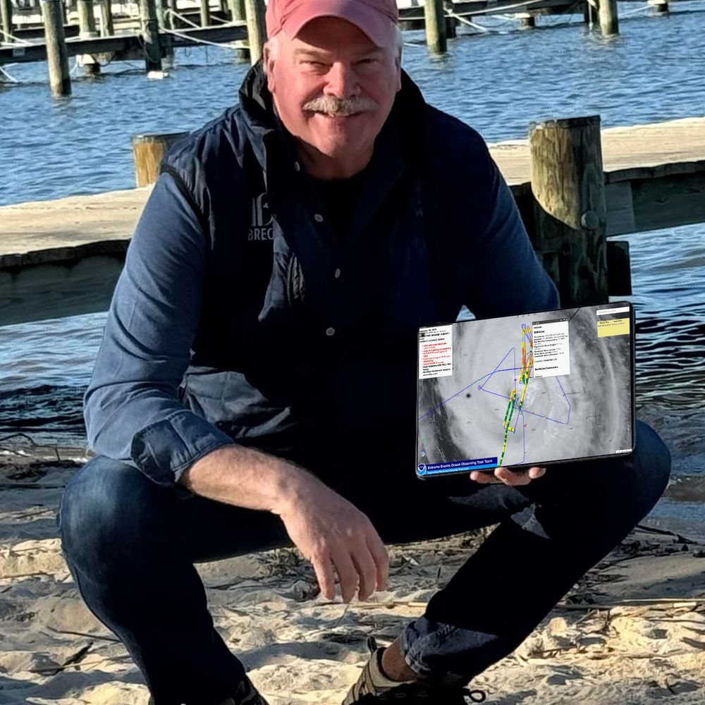
This is what I mean when I say “Research to Operations” can save lives when executed efficiently. It is so exciting to have developed GeoCollaborate to accelerate data into decision making environments! 🧪
Okay, more for you science/data geeks from today's briefing. Looking at marine traffic, guess where Hurricane Erin is (hint the big hole) and right after Hurricane Hunters dropped a wave drifter, here's the data!!! @geocollaborate.bsky.social 🧪🌀


August 20, 2025 at 11:52 PM
This is what I mean when I say “Research to Operations” can save lives when executed efficiently. It is so exciting to have developed GeoCollaborate to accelerate data into decision making environments! 🧪
#Franklin Fire, #Atmospheric River and #Wind in NE, and more. All in today's update for the All Hazards Consortium by Dave Jones, StormCenter Communications, @geocollaborate.bsky.social . Satellite imagery, GeoCollaborate sharing data and advisories! #weather 🧪🌧️🌨️🌬️
www.youtube.com/watch?v=Qtxc...
www.youtube.com/watch?v=Qtxc...

20241211 Franklin Fire, Atmospheric River Coming and Strong Winds Whipping up Snow and Damage in NE
YouTube video by StormCenter Communications | GeoCollaborate
www.youtube.com
December 11, 2024 at 9:57 PM
#Franklin Fire, #Atmospheric River and #Wind in NE, and more. All in today's update for the All Hazards Consortium by Dave Jones, StormCenter Communications, @geocollaborate.bsky.social . Satellite imagery, GeoCollaborate sharing data and advisories! #weather 🧪🌧️🌨️🌬️
www.youtube.com/watch?v=Qtxc...
www.youtube.com/watch?v=Qtxc...
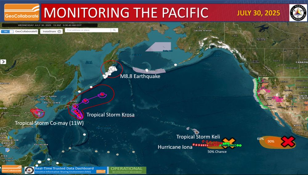
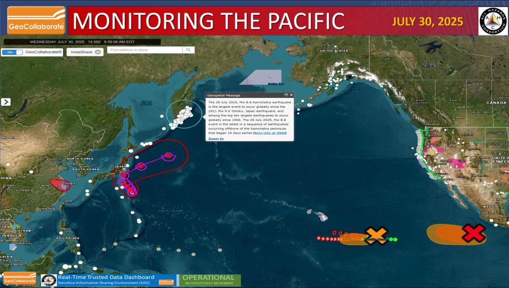
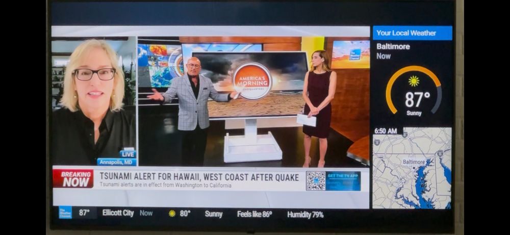
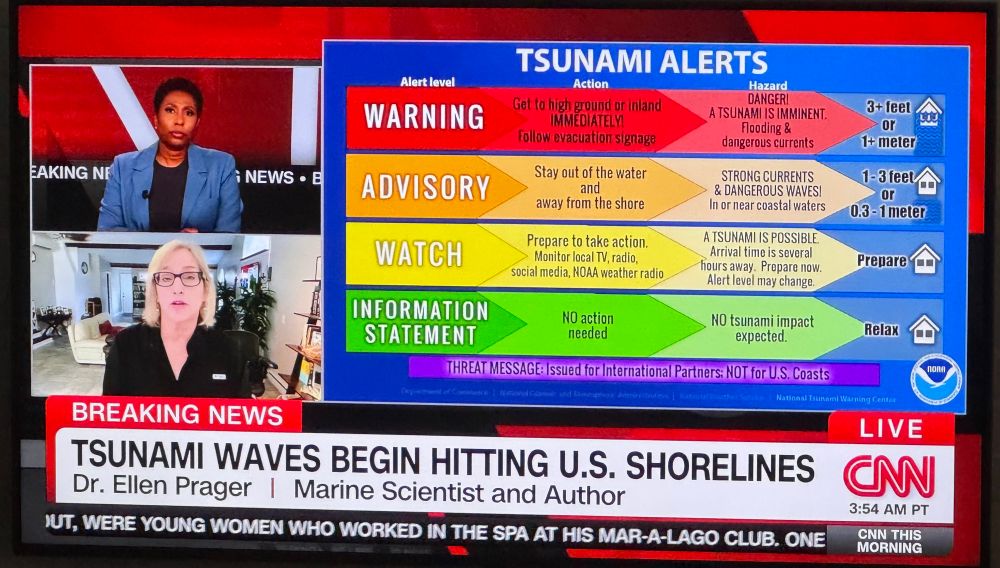
So…how’s your day going? The Pacific is on fire..(referring to activity). GeoCollaborate is monitoring and sharing real-time data to decision makers! Ocean observations are so critical! How do you think NOAA confirms a tsunami? We can not afford to lose ocean observations! @elprager.bsky.social 🔥🧪
July 30, 2025 at 2:19 PM
So…how’s your day going? The Pacific is on fire..(referring to activity). GeoCollaborate is monitoring and sharing real-time data to decision makers! Ocean observations are so critical! How do you think NOAA confirms a tsunami? We can not afford to lose ocean observations! @elprager.bsky.social 🔥🧪
Weather Update for the All Hazards Consortium by Dave Jones @geocollaborate.bsky.social. Satellite imagery, data in geocollaborate and more. Talking lake affect snow piling up, developing atmospheric river out west, snow coming and the chill is on for many. 🧪🌨️
www.youtube.com/watch?v=I8RW...
www.youtube.com/watch?v=I8RW...

20241203 Lake Effect Snow, Cold Air & Atmospheric River Update for PAC NW
YouTube video by StormCenter Communications | GeoCollaborate
www.youtube.com
December 3, 2024 at 9:10 PM
Weather Update for the All Hazards Consortium by Dave Jones @geocollaborate.bsky.social. Satellite imagery, data in geocollaborate and more. Talking lake affect snow piling up, developing atmospheric river out west, snow coming and the chill is on for many. 🧪🌨️
www.youtube.com/watch?v=I8RW...
www.youtube.com/watch?v=I8RW...
Research cruise turns into critical deployment! UNCW deploying wave drifters in partnership with SCRIPPS just in time to monitor conditions due to soon to be #HurricaneErin. NOAA Hurricane Hunters arrived in Barbados (see flight track in GeoCollaborate), next getting ready to fly into Erin. 🧪🌀


August 13, 2025 at 9:02 PM
Research cruise turns into critical deployment! UNCW deploying wave drifters in partnership with SCRIPPS just in time to monitor conditions due to soon to be #HurricaneErin. NOAA Hurricane Hunters arrived in Barbados (see flight track in GeoCollaborate), next getting ready to fly into Erin. 🧪🌀
Hurricane Flossie almost CAT3, severe storms & floods batter the East, heat out West in today's update for the All Hazards Consortium. Using GeoCollaborate to show you data, images, & information to explain what's happening.Now being translating into 10 languages! 🧪🌀
www.youtube.com/watch?v=2ytI...
www.youtube.com/watch?v=2ytI...

Hurricane Flossie Almost CAT3 While Severe Storms Batter the East with Flash Floods SISE Update
YouTube video by StormCenter Communications | GeoCollaborate
www.youtube.com
July 1, 2025 at 9:37 PM
Hurricane Flossie almost CAT3, severe storms & floods batter the East, heat out West in today's update for the All Hazards Consortium. Using GeoCollaborate to show you data, images, & information to explain what's happening.Now being translating into 10 languages! 🧪🌀
www.youtube.com/watch?v=2ytI...
www.youtube.com/watch?v=2ytI...
Talk about improving efficiency! GeoCollaborate can save millions for the FedGovt and save more lives. The private sector can benefit as well…big time. Drop us a line…
Data is more powerful when shared collaboratively and readily accessible! We are supporting #hurricane aircraft reconnaissance missions so that for the first time flight plans and live tracks can be integrated with a host of disparate #data using GeoCollaborate. To learn more, get in touch! 🧪🌀🌊🌎
September 25, 2025 at 4:26 PM
Talk about improving efficiency! GeoCollaborate can save millions for the FedGovt and save more lives. The private sector can benefit as well…big time. Drop us a line…
I LOVE the sticker we placed in every book!! 🌊 “Use more ocean data” That’s what #GeoCollaborate does too!!❤️🌎🌍🌏 #IOOS 🧪 #usemoreoceandata

July 3, 2025 at 4:58 PM
I LOVE the sticker we placed in every book!! 🌊 “Use more ocean data” That’s what #GeoCollaborate does too!!❤️🌎🌍🌏 #IOOS 🧪 #usemoreoceandata
Nor'Easter with strong winds, high waves, & coastal flooding & severe weather in PA in today's weather impacts briefing for the All Hazards Consortium. Using satellite imagery, observations, & GeoCollaborate to explain what's happening and help prepare for impacts.🧪
www.youtube.com/watch?v=X8U0...
www.youtube.com/watch?v=X8U0...

Nor'Easter Developing with Strong Winds and Coastal Flooding, Pennsylvania Tornado Warning
YouTube video by StormCenter Communications | GeoCollaborate
www.youtube.com
May 21, 2025 at 11:04 PM
Nor'Easter with strong winds, high waves, & coastal flooding & severe weather in PA in today's weather impacts briefing for the All Hazards Consortium. Using satellite imagery, observations, & GeoCollaborate to explain what's happening and help prepare for impacts.🧪
www.youtube.com/watch?v=X8U0...
www.youtube.com/watch?v=X8U0...
Okay you weather, science and tech geeks out there. Using GeoCollaborate, Dave Jones @geocollaborate.bsky.social showing Hurricane Hunter Miss Piggy flying into #Erin overlay with satellite image in today's briefing. 🧪🌀

August 15, 2025 at 12:13 AM
Okay you weather, science and tech geeks out there. Using GeoCollaborate, Dave Jones @geocollaborate.bsky.social showing Hurricane Hunter Miss Piggy flying into #Erin overlay with satellite image in today's briefing. 🧪🌀
Tropical update for All Hazards Consortium by @geocollaborate. Latest on slow-moving Tropical Storm Sara, deluge in Central America, sea surface temps, and what's next. Also coastal flooding and erosion Mid-Atlantic coast. #Sara #Tropicswx #flooding #Rodanthe 🧪🌧️🌊
www.youtube.com/watch?v=K0Tk...
www.youtube.com/watch?v=K0Tk...

20241115 Tropical Storm Sara Update Flooding in North Carolina SISE
YouTube video by StormCenter Communications | GeoCollaborate
www.youtube.com
November 15, 2024 at 7:34 PM
Tropical update for All Hazards Consortium by @geocollaborate. Latest on slow-moving Tropical Storm Sara, deluge in Central America, sea surface temps, and what's next. Also coastal flooding and erosion Mid-Atlantic coast. #Sara #Tropicswx #flooding #Rodanthe 🧪🌧️🌊
www.youtube.com/watch?v=K0Tk...
www.youtube.com/watch?v=K0Tk...
This launch is seriously amazing! Cant wait to get #NISAR into GeoCollaborate.

Liftoff! The NASA-ISRO Synthetic Aperture Radar mission has launched from Satish Dhawan Space Centre. #NISAR will scan the entire globe twice every 12 days to measure changes in Earth’s ecosystems, cryosphere, and land surface.
“It’s orbiting magic.” —Alex Gardner, NASAJPL
eos.org/articles/tra...
“It’s orbiting magic.” —Alex Gardner, NASAJPL
eos.org/articles/tra...
July 31, 2025 at 12:39 AM
This launch is seriously amazing! Cant wait to get #NISAR into GeoCollaborate.
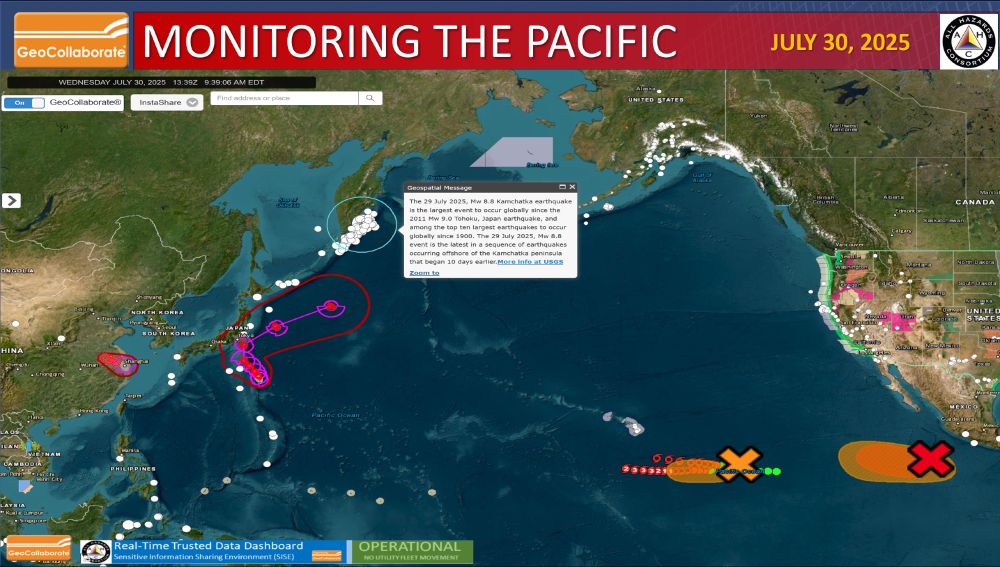
Lots going on in the Pacific. StormCenter Communications' GeoCollaborate is monitoring and sharing data across platforms in real-time. @geocollaborate.bsky.social 🧪🌊🌀
July 30, 2025 at 2:04 PM
Lots going on in the Pacific. StormCenter Communications' GeoCollaborate is monitoring and sharing data across platforms in real-time. @geocollaborate.bsky.social 🧪🌊🌀
It is infinitely frustrating to have a solution…an innovation that can change the entire decision making landscape and have people look at you like you have two heads! GeoCollaborate is an SBIR Phase III…look it up. 🧪
Great story, resources. But wouldn't it be better with region relevant real-time data all on one map! Multiple sources, formats but just one map and easy access. That's GeoCollaborate, patented and developed through the SBIR program! @geocollaborate.bsky.social 🧪
www.tampabay.com/hurricane/20...
www.tampabay.com/hurricane/20...

Want to know what areas are flooding in Tampa Bay? Here’s where to look
Here’s how to access real-time flooding data.
www.tampabay.com
May 30, 2025 at 10:27 PM
It is infinitely frustrating to have a solution…an innovation that can change the entire decision making landscape and have people look at you like you have two heads! GeoCollaborate is an SBIR Phase III…look it up. 🧪
Great story, resources. But wouldn't it be better with region relevant real-time data all on one map! Multiple sources, formats but just one map and easy access. That's GeoCollaborate, patented and developed through the SBIR program! @geocollaborate.bsky.social 🧪
www.tampabay.com/hurricane/20...
www.tampabay.com/hurricane/20...
Want to know what areas are flooding in Tampa Bay? Here’s where to look
Here’s how to access real-time flooding data.
www.tampabay.com
May 30, 2025 at 6:43 PM
Great story, resources. But wouldn't it be better with region relevant real-time data all on one map! Multiple sources, formats but just one map and easy access. That's GeoCollaborate, patented and developed through the SBIR program! @geocollaborate.bsky.social 🧪
www.tampabay.com/hurricane/20...
www.tampabay.com/hurricane/20...