


Yoshii64
@yoshii64.bsky.social
Aspiring journalist and meteorologist. Will cover weather, government, news, and more
Today, all these news organizations have left the Pentagon press area, taking chairs, supplies, and information with them. This is due to the Pentagon's new rules which breaks press freedom by making press only report approved stories if they sign.
The Big Five have signed a letter in condemnation.
The Big Five have signed a letter in condemnation.

October 15, 2025 at 9:34 PM
Today, all these news organizations have left the Pentagon press area, taking chairs, supplies, and information with them. This is due to the Pentagon's new rules which breaks press freedom by making press only report approved stories if they sign.
The Big Five have signed a letter in condemnation.
The Big Five have signed a letter in condemnation.
I can't post on Twitter it seems. Great job guys


June 2, 2025 at 5:49 PM
I can't post on Twitter it seems. Great job guys
Looks like the storms are ramping up

March 20, 2025 at 8:11 PM
Looks like the storms are ramping up
A thin line of rain heading through our area right now. Anyone in the Tampa Bay Area is expected to see this line of rain. Rain will only happen for at most 20 minutes though

March 20, 2025 at 7:57 PM
A thin line of rain heading through our area right now. Anyone in the Tampa Bay Area is expected to see this line of rain. Rain will only happen for at most 20 minutes though

Woah that's a surprise

March 1, 2025 at 3:42 AM
Woah that's a surprise
Hello Florida! Three radars and satellite is set up for a general overview. Northern Floridians, especially those in the red area, should be ready for rain in the next few hours. Tomorrow, the cold front will traverse all through Florida, although low-precip South of Gainesville.

February 13, 2025 at 3:48 AM
Hello Florida! Three radars and satellite is set up for a general overview. Northern Floridians, especially those in the red area, should be ready for rain in the next few hours. Tomorrow, the cold front will traverse all through Florida, although low-precip South of Gainesville.
Everywhere in the U.S. has great moisture... except Florida.


February 10, 2025 at 8:51 PM
Everywhere in the U.S. has great moisture... except Florida.
@weatherprof.bsky.social How likely do you think Tampa Bay will get a freeze this year? (A day or more of low temperatures below freezing)

November 24, 2024 at 4:49 PM
@weatherprof.bsky.social How likely do you think Tampa Bay will get a freeze this year? (A day or more of low temperatures below freezing)
Looks like I can look at computer models on the go now.
Just got data and a number.
Just got data and a number.

November 21, 2024 at 12:40 PM
Looks like I can look at computer models on the go now.
Just got data and a number.
Just got data and a number.
The EURO shows exactly that while the GFS has a very powerful Alaskan high and a powerful high near Iceland. Back to the ensembles for a moment they also show such a scenario, likely to get clearer as we get closer. A Florida forecast will be released tonight or tomorrow. Have a good day yall!


November 18, 2024 at 12:58 AM
The EURO shows exactly that while the GFS has a very powerful Alaskan high and a powerful high near Iceland. Back to the ensembles for a moment they also show such a scenario, likely to get clearer as we get closer. A Florida forecast will be released tonight or tomorrow. Have a good day yall!
The PNA will also rise right after. A +PNA usually allows cold air to seep into the East Coast. Going into clownery range (we were there already) again, we do see a good pattern for EC cold lovers. Alaska and North Atlantic/Greenland high usually forces cold air to rush into the U.S.

November 18, 2024 at 12:58 AM
The PNA will also rise right after. A +PNA usually allows cold air to seep into the East Coast. Going into clownery range (we were there already) again, we do see a good pattern for EC cold lovers. Alaska and North Atlantic/Greenland high usually forces cold air to rush into the U.S.
The AO! Basically part of what determines arctic blasts and it looks to support some extra troughs after our big one. After the big trough it's gonna get near neutral, then very slowly drop, bringing us a good start to December. Same is happening to the AMO.


November 18, 2024 at 12:58 AM
The AO! Basically part of what determines arctic blasts and it looks to support some extra troughs after our big one. After the big trough it's gonna get near neutral, then very slowly drop, bringing us a good start to December. Same is happening to the AMO.
The GFS and EURO show yet another trough somewhen right before December. The general pattern does support this, more of the teleconnections next post but this specific trough is very uncertain, however, personally, I think it's not a false signal.


November 18, 2024 at 12:58 AM
The GFS and EURO show yet another trough somewhen right before December. The general pattern does support this, more of the teleconnections next post but this specific trough is very uncertain, however, personally, I think it's not a false signal.
The ensembles dont support it at all either. The trough builds on all. Here's an example from the EPS. However this is where we end with the ensembles, mainly because in late ranges like these, they really tone down the troughs' and ridges' power.

November 18, 2024 at 12:58 AM
The ensembles dont support it at all either. The trough builds on all. Here's an example from the EPS. However this is where we end with the ensembles, mainly because in late ranges like these, they really tone down the troughs' and ridges' power.
Well a ridge will build up again, however not a very strong one. Dry, cool air should remain in most places until a second trough comes. This second trough's existence is a bit more uncertain. The GFS has it well defined, while the EURO and CMC have it less powerful, and the AIFS does not have it.


November 18, 2024 at 12:58 AM
Well a ridge will build up again, however not a very strong one. Dry, cool air should remain in most places until a second trough comes. This second trough's existence is a bit more uncertain. The GFS has it well defined, while the EURO and CMC have it less powerful, and the AIFS does not have it.
And the ensembles really agree too, both with oper. and with each other. GEFS is the only outlier I'd say, however still showing a powerful trough. But what about beyond?


November 18, 2024 at 12:58 AM
And the ensembles really agree too, both with oper. and with each other. GEFS is the only outlier I'd say, however still showing a powerful trough. But what about beyond?
Looking at all the operational models, they show something very similar to the EURO, within the 5 day range too. If you don't pay too much attention to specific lines, you may think these three model frames are the exact same thing. However to really get a consensus, we must look at ensembles


November 18, 2024 at 12:58 AM
Looking at all the operational models, they show something very similar to the EURO, within the 5 day range too. If you don't pay too much attention to specific lines, you may think these three model frames are the exact same thing. However to really get a consensus, we must look at ensembles
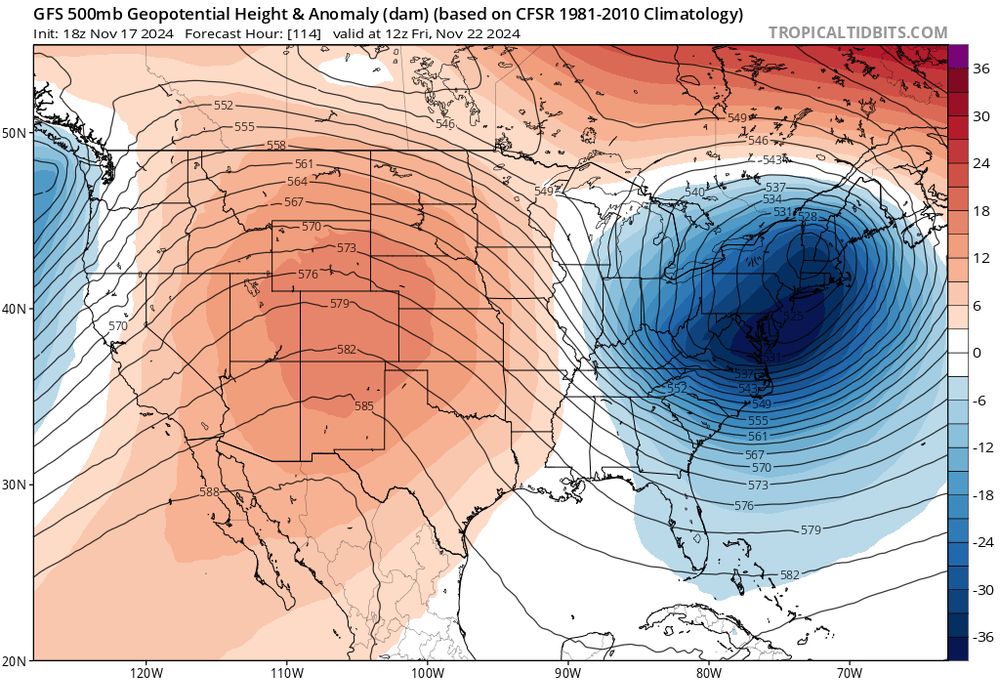
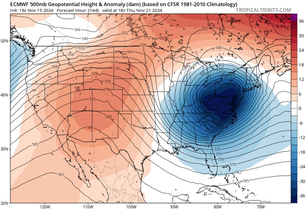
Jesus, EURO.
Let's talk about this, and a forecast for the rest of Nov. (A THREAD!):
For those who do not know the blue is a trough, bringing colder air, while the red is a ridge, bringing warmer air. All models suggest a powerful trough sweeping through the Eastern U.S. and bringing cold air
Let's talk about this, and a forecast for the rest of Nov. (A THREAD!):
For those who do not know the blue is a trough, bringing colder air, while the red is a ridge, bringing warmer air. All models suggest a powerful trough sweeping through the Eastern U.S. and bringing cold air

November 18, 2024 at 12:58 AM
Jesus, EURO.
Let's talk about this, and a forecast for the rest of Nov. (A THREAD!):
For those who do not know the blue is a trough, bringing colder air, while the red is a ridge, bringing warmer air. All models suggest a powerful trough sweeping through the Eastern U.S. and bringing cold air
Let's talk about this, and a forecast for the rest of Nov. (A THREAD!):
For those who do not know the blue is a trough, bringing colder air, while the red is a ridge, bringing warmer air. All models suggest a powerful trough sweeping through the Eastern U.S. and bringing cold air
Twitter WANTS me to leave

November 16, 2024 at 4:33 AM
Twitter WANTS me to leave
All major models show a powerful trough next Thursday for the Eastern U.S. and it looks to flip the pattern. For the last month or two, we have had a warm East Coast and cold West. Soon this trough/cold front will allow the switch to happen. Cannot wait


November 16, 2024 at 4:23 AM
All major models show a powerful trough next Thursday for the Eastern U.S. and it looks to flip the pattern. For the last month or two, we have had a warm East Coast and cold West. Soon this trough/cold front will allow the switch to happen. Cannot wait
Wow, GFS. We got a huge trough coming on, which the models have only amplified recently. Down here in Florida, we might get our first 40s low temps.

November 15, 2024 at 4:00 AM
Wow, GFS. We got a huge trough coming on, which the models have only amplified recently. Down here in Florida, we might get our first 40s low temps.
No one can find where I am!!!

October 21, 2024 at 1:24 PM
No one can find where I am!!!
Like how Twitter does replies still? Well you can change Bluesky to do that. I'd recommend doing these settings for everyone honestly. Not enough people check preference settings.

October 19, 2024 at 4:16 PM
Like how Twitter does replies still? Well you can change Bluesky to do that. I'd recommend doing these settings for everyone honestly. Not enough people check preference settings.