


@WxWeatherCfield
@wxweathercfield.bsky.social
Passionate about winter weather in Chesterfield and the surrounding areas.

December 7, 2025 at 8:06 PM
18z HRR short range model holds serve. 1-4 inches of snow seems likely. Here is the first call for Chesterfield:
Northern Chesterfield (Westchester commons north) - 1-2 inches
Central Chesterfield (route 60 to route 10) - 2-3 inches
Southern Chesterfield (south of route 10) - 3-4 inches
Northern Chesterfield (Westchester commons north) - 1-2 inches
Central Chesterfield (route 60 to route 10) - 2-3 inches
Southern Chesterfield (south of route 10) - 3-4 inches
December 7, 2025 at 8:03 PM
18z HRR short range model holds serve. 1-4 inches of snow seems likely. Here is the first call for Chesterfield:
Northern Chesterfield (Westchester commons north) - 1-2 inches
Central Chesterfield (route 60 to route 10) - 2-3 inches
Southern Chesterfield (south of route 10) - 3-4 inches
Northern Chesterfield (Westchester commons north) - 1-2 inches
Central Chesterfield (route 60 to route 10) - 2-3 inches
Southern Chesterfield (south of route 10) - 3-4 inches
First Call:
This is a general area wide event as it stands now.
I believe snow begins by 4-5 AM. There will be some heavy bursts, which will make for a terrible AM commute.
Snow tapers off around noon.
Total accumulation: 2-3 inches area-wide.
I will post again this afternoon!
This is a general area wide event as it stands now.
I believe snow begins by 4-5 AM. There will be some heavy bursts, which will make for a terrible AM commute.
Snow tapers off around noon.
Total accumulation: 2-3 inches area-wide.
I will post again this afternoon!
December 4, 2025 at 11:09 AM
First Call:
This is a general area wide event as it stands now.
I believe snow begins by 4-5 AM. There will be some heavy bursts, which will make for a terrible AM commute.
Snow tapers off around noon.
Total accumulation: 2-3 inches area-wide.
I will post again this afternoon!
This is a general area wide event as it stands now.
I believe snow begins by 4-5 AM. There will be some heavy bursts, which will make for a terrible AM commute.
Snow tapers off around noon.
Total accumulation: 2-3 inches area-wide.
I will post again this afternoon!
IF the snow starts between 6 and 9 AM, it cuts down on some snow totals as this is a generally light event with some moderate bursts and the sun angle is still strong enough to cause some melting. IF the snow begins between 3 and 6 AM as some models are now seeing, there will be more accumulation.
December 4, 2025 at 11:07 AM
IF the snow starts between 6 and 9 AM, it cuts down on some snow totals as this is a generally light event with some moderate bursts and the sun angle is still strong enough to cause some melting. IF the snow begins between 3 and 6 AM as some models are now seeing, there will be more accumulation.
Looking at all of the models this morning there is complete consensus between the short range NAM,HRR, and RGEM for a general area wide 1-3 inch snow event. The EURO sniffed this out first and maintained a steady hold! The key will be timing of the precipitation!
December 4, 2025 at 11:05 AM
Looking at all of the models this morning there is complete consensus between the short range NAM,HRR, and RGEM for a general area wide 1-3 inch snow event. The EURO sniffed this out first and maintained a steady hold! The key will be timing of the precipitation!
Good Morning RVA!! It’s winter weather season! We are now within 24 hours of our first potential storm, so it’s time to kick off snow season in Virginia!
December 4, 2025 at 11:03 AM
Good Morning RVA!! It’s winter weather season! We are now within 24 hours of our first potential storm, so it’s time to kick off snow season in Virginia!
Winter is officially over. Tonight we spring ahead and all long range models show warmups and springtime! Yes there will be some cold mornings, but winter is O-V-E-R!
March 8, 2025 at 11:44 PM
Winter is officially over. Tonight we spring ahead and all long range models show warmups and springtime! Yes there will be some cold mornings, but winter is O-V-E-R!
It is so nice outside today!! Make sure to get outside and enjoy! The next two days are also looking spectacular in Chesterfield!!
February 23, 2025 at 7:30 PM
It is so nice outside today!! Make sure to get outside and enjoy! The next two days are also looking spectacular in Chesterfield!!
Looking ahead things look pretty mild and calm for a week or so. Get outside and enjoy the beautiful 60 degree weather that is coming up! It may even get close to 70 on Tuesday! Don’t get too used to it though….March is always a wild weather month!
February 22, 2025 at 2:38 PM
Looking ahead things look pretty mild and calm for a week or so. Get outside and enjoy the beautiful 60 degree weather that is coming up! It may even get close to 70 on Tuesday! Don’t get too used to it though….March is always a wild weather month!
There were several meteorologists who upped the totals drastically based off of one run of a model. Always look at trends before making a decision. I went with 3-7 from the beginning because it was a daytime storm, late phase, and the model trend was a moderate, not heavy snow.
February 21, 2025 at 1:02 AM
There were several meteorologists who upped the totals drastically based off of one run of a model. Always look at trends before making a decision. I went with 3-7 from the beginning because it was a daytime storm, late phase, and the model trend was a moderate, not heavy snow.
5) meteorology is fun but you need to be careful with watching model runs one by one and then creating a forecast based off of it. Rather - look at trends, especially within 48 hours on the short range models. The trend was clear that Richmond would get snow; however, it wasn’t going to be a foot.
February 21, 2025 at 1:00 AM
5) meteorology is fun but you need to be careful with watching model runs one by one and then creating a forecast based off of it. Rather - look at trends, especially within 48 hours on the short range models. The trend was clear that Richmond would get snow; however, it wasn’t going to be a foot.
3) the north and west trend only goes so far whenever a phase doesn’t occur until offshore and the low is moving east (ie Carolina slider)
4) it takes incredibly perfect conditions for central Virginia to get a major snowstorm
4) it takes incredibly perfect conditions for central Virginia to get a major snowstorm
February 21, 2025 at 12:58 AM
3) the north and west trend only goes so far whenever a phase doesn’t occur until offshore and the low is moving east (ie Carolina slider)
4) it takes incredibly perfect conditions for central Virginia to get a major snowstorm
4) it takes incredibly perfect conditions for central Virginia to get a major snowstorm
Storm reflection notes:
1) the sun angle in Virginia, especially in February, limits the accumulation if the snow isn’t heavy. This is why roads didn’t cover at various points during the day.
2) if the storm came at night, the accumulation may have doubled.
1) the sun angle in Virginia, especially in February, limits the accumulation if the snow isn’t heavy. This is why roads didn’t cover at various points during the day.
2) if the storm came at night, the accumulation may have doubled.
February 21, 2025 at 12:57 AM
Storm reflection notes:
1) the sun angle in Virginia, especially in February, limits the accumulation if the snow isn’t heavy. This is why roads didn’t cover at various points during the day.
2) if the storm came at night, the accumulation may have doubled.
1) the sun angle in Virginia, especially in February, limits the accumulation if the snow isn’t heavy. This is why roads didn’t cover at various points during the day.
2) if the storm came at night, the accumulation may have doubled.
Send in those storm reports! How much snow did you get in your area? Here in Moseley, we have 4 inches on the ground this morning. My first, second, and final call was for 3-7 inches; for the most part, I think this verified for Chesterfield. I’ll explain my rationale in a few!
February 20, 2025 at 1:30 PM
Send in those storm reports! How much snow did you get in your area? Here in Moseley, we have 4 inches on the ground this morning. My first, second, and final call was for 3-7 inches; for the most part, I think this verified for Chesterfield. I’ll explain my rationale in a few!
Where will the moderate to heavy banding set up in a couple of hours? Is it a line from say Petersburg to Williamsburg? Or is it a touch further west from say south hill through Richmond? Time will tell!
February 19, 2025 at 5:47 PM
Where will the moderate to heavy banding set up in a couple of hours? Is it a line from say Petersburg to Williamsburg? Or is it a touch further west from say south hill through Richmond? Time will tell!
3-7 inches looks on target. How is the snow by you?
February 19, 2025 at 2:40 PM
3-7 inches looks on target. How is the snow by you?
12z models brought back a ton of moisture. The start of the 18z models have backed off some. Final call tonight but still looking at a 3-7 inch type storm for Chesterfield. Ratios will be great (15 or 20:1) so if we can get under a good band that drops 0.5 inches of liquid, that would give 7-10 in
February 18, 2025 at 8:28 PM
12z models brought back a ton of moisture. The start of the 18z models have backed off some. Final call tonight but still looking at a 3-7 inch type storm for Chesterfield. Ratios will be great (15 or 20:1) so if we can get under a good band that drops 0.5 inches of liquid, that would give 7-10 in
0z models are starting to come in and all are providing more snow to Chesterfield!
SREF - 8-12 inches
NAM - 8-12 inches
GFS - 6-10 inches
I will follow back up in the morning!
SREF - 8-12 inches
NAM - 8-12 inches
GFS - 6-10 inches
I will follow back up in the morning!
February 18, 2025 at 4:00 AM
0z models are starting to come in and all are providing more snow to Chesterfield!
SREF - 8-12 inches
NAM - 8-12 inches
GFS - 6-10 inches
I will follow back up in the morning!
SREF - 8-12 inches
NAM - 8-12 inches
GFS - 6-10 inches
I will follow back up in the morning!
Reposted by @WxWeatherCfield
FIRST CALL SNOW & & DISCUSSION
tinyurl.com/mryuskmh
tinyurl.com/mryuskmh
FIRST CALL SNOW MAP FOR FEBRUARY 19–20
This storm has been so frustrating, so aggravating to forecast that I have to eat at least one chocolate chip croissant every 6 hours along…
tinyurl.com
February 18, 2025 at 1:50 AM
FIRST CALL SNOW & & DISCUSSION
tinyurl.com/mryuskmh
tinyurl.com/mryuskmh
I will update everyone during the 0z runs later tonight and then the 6z runs in the morning! There may not be many who follow along but if it helps someone than it’s worth it!
Final call for the storm will be tomorrow (Tuesday) evening.
Final call for the storm will be tomorrow (Tuesday) evening.
February 17, 2025 at 11:29 PM
I will update everyone during the 0z runs later tonight and then the 6z runs in the morning! There may not be many who follow along but if it helps someone than it’s worth it!
Final call for the storm will be tomorrow (Tuesday) evening.
Final call for the storm will be tomorrow (Tuesday) evening.
What crazy tough call it’ll be for Chesterfield based on 18z models. The north and West trend definitely started today but will it keep going?
EURO says 2-4
GFS says 8-10
NAM says 8-10
CMC says 3-6
RGEM says 3-6
ICON says 2-4
SREF says 6-10
Second Call Prediction for Chesterfield:
3-7 inches
EURO says 2-4
GFS says 8-10
NAM says 8-10
CMC says 3-6
RGEM says 3-6
ICON says 2-4
SREF says 6-10
Second Call Prediction for Chesterfield:
3-7 inches
February 17, 2025 at 11:28 PM
What crazy tough call it’ll be for Chesterfield based on 18z models. The north and West trend definitely started today but will it keep going?
EURO says 2-4
GFS says 8-10
NAM says 8-10
CMC says 3-6
RGEM says 3-6
ICON says 2-4
SREF says 6-10
Second Call Prediction for Chesterfield:
3-7 inches
EURO says 2-4
GFS says 8-10
NAM says 8-10
CMC says 3-6
RGEM says 3-6
ICON says 2-4
SREF says 6-10
Second Call Prediction for Chesterfield:
3-7 inches
We are now within 48 hours and the trend has started.
Finally do not forget the seasonal Trend of this winter. Once we go within 48 Hours it has a tendency of Shifting back to the north and west a little bit. If the strength were to hold it would push the heaviest snow area back into Richmond and closer to DC in Charlottesville /4
February 17, 2025 at 3:42 PM
We are now within 48 hours and the trend has started.
UPDATE! UPDATE! UPDATE!
12z ICON model follows the NAM and puts down 6-8 inches of snow in Chesterfield!
While the RGEM didn’t bring in big numbers during its 12z run, it did expand the precipitation shield to the north and west.
Is this the start of a true trend? The GFS is up next!
12z ICON model follows the NAM and puts down 6-8 inches of snow in Chesterfield!
While the RGEM didn’t bring in big numbers during its 12z run, it did expand the precipitation shield to the north and west.
Is this the start of a true trend? The GFS is up next!
February 17, 2025 at 3:26 PM
UPDATE! UPDATE! UPDATE!
12z ICON model follows the NAM and puts down 6-8 inches of snow in Chesterfield!
While the RGEM didn’t bring in big numbers during its 12z run, it did expand the precipitation shield to the north and west.
Is this the start of a true trend? The GFS is up next!
12z ICON model follows the NAM and puts down 6-8 inches of snow in Chesterfield!
While the RGEM didn’t bring in big numbers during its 12z run, it did expand the precipitation shield to the north and west.
Is this the start of a true trend? The GFS is up next!
UPDATE! UPDATE! UPDATE!
12z NAM (first model of the 12z suite) stops the south east trend and even brings more precipitation to the north and west. Snow totals on the model are 6-8 inches for Chesterfield. We are in the NAM’s wheelhouse (inside 48 hours). Is it catching onto something!?
12z NAM (first model of the 12z suite) stops the south east trend and even brings more precipitation to the north and west. Snow totals on the model are 6-8 inches for Chesterfield. We are in the NAM’s wheelhouse (inside 48 hours). Is it catching onto something!?
February 17, 2025 at 2:46 PM
UPDATE! UPDATE! UPDATE!
12z NAM (first model of the 12z suite) stops the south east trend and even brings more precipitation to the north and west. Snow totals on the model are 6-8 inches for Chesterfield. We are in the NAM’s wheelhouse (inside 48 hours). Is it catching onto something!?
12z NAM (first model of the 12z suite) stops the south east trend and even brings more precipitation to the north and west. Snow totals on the model are 6-8 inches for Chesterfield. We are in the NAM’s wheelhouse (inside 48 hours). Is it catching onto something!?
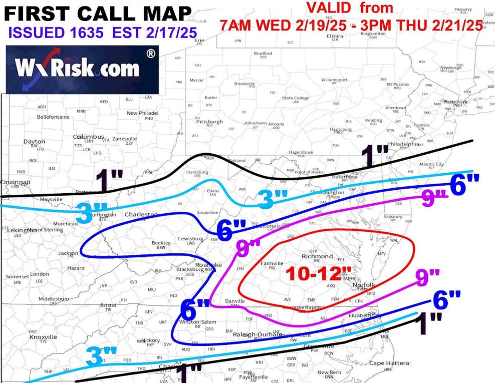
Second guess for snowfall accumulation out at noon today!
Final call Tuesday afternoon/evening!
Final call Tuesday afternoon/evening!
February 17, 2025 at 1:20 PM
Second guess for snowfall accumulation out at noon today!
Final call Tuesday afternoon/evening!
Final call Tuesday afternoon/evening!