


Nahel Belgherze
@wxnb.bsky.social
Mainly focused on covering extreme weather events worldwide. Also interested in climate dynamics, geohazards and satellite remote sensing. Also on X: x.com/wxnb_
This has to be unheard of. With an extraordinary peak flash rate of 699 flashes per minute just prior to landfall in Jamaica, Melissa probably set the record for the most prolific inner-core lightning outbreak ever recorded in an Atlantic hurricane.

November 6, 2025 at 5:40 PM
This has to be unheard of. With an extraordinary peak flash rate of 699 flashes per minute just prior to landfall in Jamaica, Melissa probably set the record for the most prolific inner-core lightning outbreak ever recorded in an Atlantic hurricane.
This is wild. Despite having fueled one of the strongest Atlantic hurricanes on record, the waters in the vicinity of where Melissa tracked remain sufficiently warm to support the formation of a major hurricane.

November 4, 2025 at 5:55 PM
This is wild. Despite having fueled one of the strongest Atlantic hurricanes on record, the waters in the vicinity of where Melissa tracked remain sufficiently warm to support the formation of a major hurricane.
NOAA aerial imagery is coming in. Hurricane Melissa literally turned western Jamaica from green to brown. Vegetation damage is immense — recovery will take years.
November 1, 2025 at 7:18 PM
NOAA aerial imagery is coming in. Hurricane Melissa literally turned western Jamaica from green to brown. Vegetation damage is immense — recovery will take years.
With 40 cm of snow left on the ground last Wednesday, Iceland’s capital, Reykjavík, officially experienced its biggest October snowstorm on record. This historic event shattered a 104-year-old record by 25 cm.

November 1, 2025 at 2:31 PM
With 40 cm of snow left on the ground last Wednesday, Iceland’s capital, Reykjavík, officially experienced its biggest October snowstorm on record. This historic event shattered a 104-year-old record by 25 cm.
The fact that we went nearly 20 years without a sub-900 mb Atlantic hurricane and now we’ve had two in just the last two seasons.
October 30, 2025 at 8:51 PM
The fact that we went nearly 20 years without a sub-900 mb Atlantic hurricane and now we’ve had two in just the last two seasons.
Reposted by Nahel Belgherze

Alrighty, ready to see something really cool? (and maybe a little nauseating)
The evolution of Hurricane Melissa's mesovortices at peak strength.
The evolution of Hurricane Melissa's mesovortices at peak strength.
October 29, 2025 at 8:10 PM
Alrighty, ready to see something really cool? (and maybe a little nauseating)
The evolution of Hurricane Melissa's mesovortices at peak strength.
The evolution of Hurricane Melissa's mesovortices at peak strength.
NEW: Devastating imagery from Jamaica, before & after Category 5 Hurricane Melissa.
Black River — near total destruction.
Black River — near total destruction.
October 29, 2025 at 8:28 PM
NEW: Devastating imagery from Jamaica, before & after Category 5 Hurricane Melissa.
Black River — near total destruction.
Black River — near total destruction.
Hurricane Melissa’s historic journey to becoming one of the most intense tropical cyclones ever recorded on Earth.
A storm we won't forget anytime soon.
A storm we won't forget anytime soon.
October 29, 2025 at 1:49 PM
Hurricane Melissa’s historic journey to becoming one of the most intense tropical cyclones ever recorded on Earth.
A storm we won't forget anytime soon.
A storm we won't forget anytime soon.
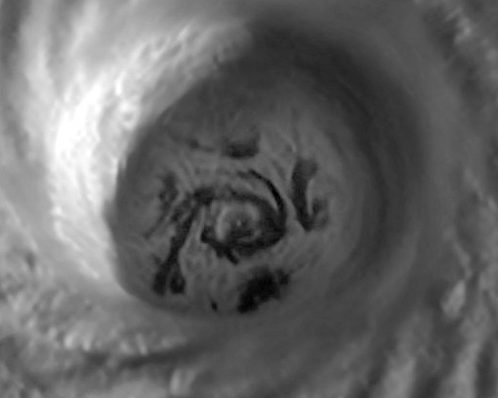
Obvious wavenumber-5 mesovortex pattern within #Melissa’s eyewall earlier today — when the simulation matches reality. Just two decades ago, the very existence of mesovortices was still a matter of debate.

October 28, 2025 at 9:22 PM
Obvious wavenumber-5 mesovortex pattern within #Melissa’s eyewall earlier today — when the simulation matches reality. Just two decades ago, the very existence of mesovortices was still a matter of debate.
Hurricane Melissa has just broken the record for the driest eye ever observed in a tropical cyclone, with a temperature of -4.75°C.
This is nothing short of astronomical.
This is nothing short of astronomical.

October 27, 2025 at 5:49 PM
Hurricane Melissa has just broken the record for the driest eye ever observed in a tropical cyclone, with a temperature of -4.75°C.
This is nothing short of astronomical.
This is nothing short of astronomical.
The marine heatwave occurring across much of the East China Sea is one of the most extreme ever recorded in this part of the world. Over the past few days, it has reached “Beyond Extreme” Category 5 status — Completely uncharted territory.

October 22, 2025 at 1:49 PM
The marine heatwave occurring across much of the East China Sea is one of the most extreme ever recorded in this part of the world. Over the past few days, it has reached “Beyond Extreme” Category 5 status — Completely uncharted territory.
Just a nice calm look at 321 hours out from the GFS.

October 15, 2025 at 9:55 AM
Just a nice calm look at 321 hours out from the GFS.
Some significant rain totals are possible across parts of the Valencian Community, Spain by the end of the weekend (+350mm). Flash flooding is possible where those biggest totals occur. Red warnings are in force.
October 10, 2025 at 9:45 AM
Some significant rain totals are possible across parts of the Valencian Community, Spain by the end of the weekend (+350mm). Flash flooding is possible where those biggest totals occur. Red warnings are in force.
Sunset on Hurricane Humberto.
A Category 5 monster.
A Category 5 monster.
September 27, 2025 at 9:16 PM
Sunset on Hurricane Humberto.
A Category 5 monster.
A Category 5 monster.
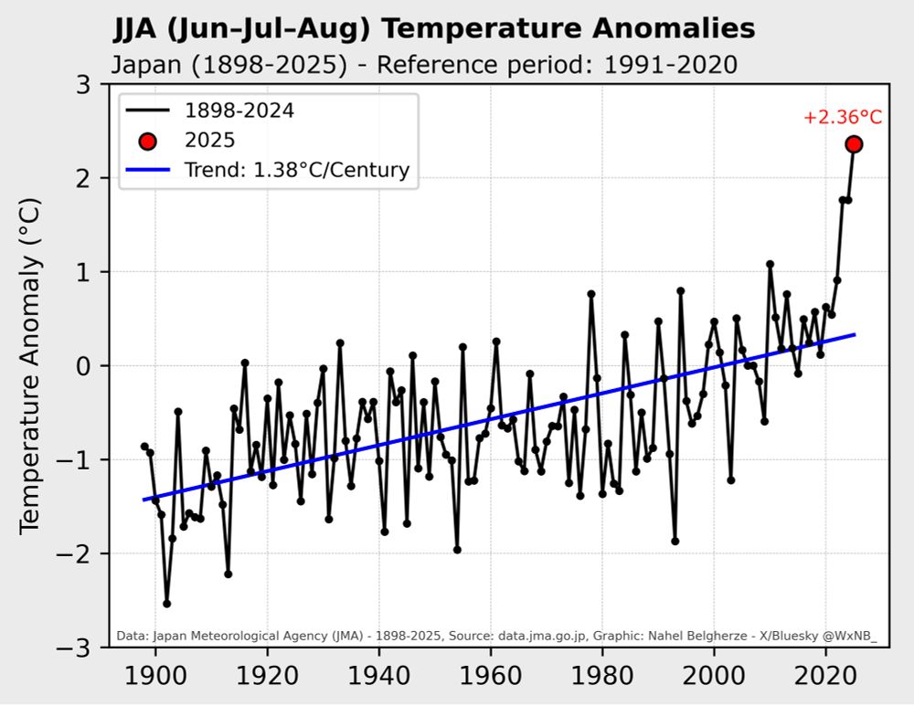
This is not normal. Japan is continuing its run of astonishing temperature records. The country has just had its hottest summer for the third year in a row, and by a substantial margin. Data: JMA
September 1, 2025 at 11:21 AM
This is not normal. Japan is continuing its run of astonishing temperature records. The country has just had its hottest summer for the third year in a row, and by a substantial margin. Data: JMA
Here’s a 48-hour water vapor loop of Ex-Hurricane Erin spinning on its final approach to Europe. Truly mesmerizing.
August 26, 2025 at 10:58 AM
Here’s a 48-hour water vapor loop of Ex-Hurricane Erin spinning on its final approach to Europe. Truly mesmerizing.
Before-and-after satellite imagery shows multiple large burn scars from the recent major wildfires in Portugal and Spain.
August 25, 2025 at 5:37 PM
Before-and-after satellite imagery shows multiple large burn scars from the recent major wildfires in Portugal and Spain.
Here’s a first-of-its-kind vertical cross-section analysis of the eyewall of Category 5 Hurricane Erin, captured by AgileRadar’s ROARS radar system installed on NOAA’s Hurricane Hunters P-3 aircraft.
August 20, 2025 at 4:07 PM
Here’s a first-of-its-kind vertical cross-section analysis of the eyewall of Category 5 Hurricane Erin, captured by AgileRadar’s ROARS radar system installed on NOAA’s Hurricane Hunters P-3 aircraft.
Hurricane Erin’s substantial wind-field expansion over the past four days.

August 20, 2025 at 12:53 PM
Hurricane Erin’s substantial wind-field expansion over the past four days.
Spain is having its worst year for wildfires.
In terms of square kilometers burned, the 2025 season far outstrips all previous years.
Many fires are still active.
In terms of square kilometers burned, the 2025 season far outstrips all previous years.
Many fires are still active.

August 19, 2025 at 6:37 PM
Spain is having its worst year for wildfires.
In terms of square kilometers burned, the 2025 season far outstrips all previous years.
Many fires are still active.
In terms of square kilometers burned, the 2025 season far outstrips all previous years.
Many fires are still active.
Unbelievable footage from NOAA’s Hurricane Hunters inside the eye of Hurricane Erin.
Simply incredible.
Simply incredible.
August 16, 2025 at 9:22 PM
Unbelievable footage from NOAA’s Hurricane Hunters inside the eye of Hurricane Erin.
Simply incredible.
Simply incredible.
Just dreadful satellite imagery of the rapidly escalating wildfire outbreak across parts of northern Portugal and western Spain.
Look at the size of that smoke plume!
Look at the size of that smoke plume!
August 15, 2025 at 6:21 PM
Just dreadful satellite imagery of the rapidly escalating wildfire outbreak across parts of northern Portugal and western Spain.
Look at the size of that smoke plume!
Look at the size of that smoke plume!
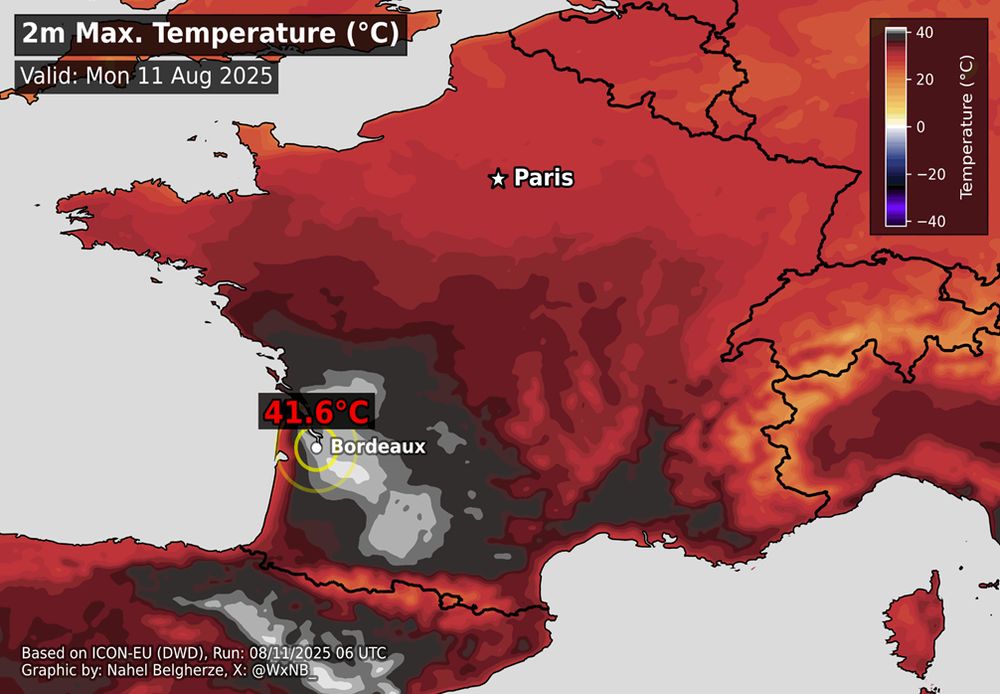
Historic heatwave unfolding in France.
Bordeaux just observed its hottest day on record with a provisional 41.6°C (107°F) — data since 1920. Red level extreme heat warnings are in force for the south of the country.
Sadly, this heatwave is far from over...
Bordeaux just observed its hottest day on record with a provisional 41.6°C (107°F) — data since 1920. Red level extreme heat warnings are in force for the south of the country.
Sadly, this heatwave is far from over...
August 11, 2025 at 2:49 PM
Historic heatwave unfolding in France.
Bordeaux just observed its hottest day on record with a provisional 41.6°C (107°F) — data since 1920. Red level extreme heat warnings are in force for the south of the country.
Sadly, this heatwave is far from over...
Bordeaux just observed its hottest day on record with a provisional 41.6°C (107°F) — data since 1920. Red level extreme heat warnings are in force for the south of the country.
Sadly, this heatwave is far from over...
The ongoing, potentially record-breaking heatwave in southern France could last longer than previously thought, according to the latest ECMWF ensemble.

August 10, 2025 at 2:23 PM
The ongoing, potentially record-breaking heatwave in southern France could last longer than previously thought, according to the latest ECMWF ensemble.
From record-breaking warmth to slightly below-average sea surface temperatures, this map highlights the remarkable cool-down that occurred in just one month in the western Mediterranean Sea. *Internal variability*

August 7, 2025 at 2:52 PM
From record-breaking warmth to slightly below-average sea surface temperatures, this map highlights the remarkable cool-down that occurred in just one month in the western Mediterranean Sea. *Internal variability*