


WxAtom
@wxatom.bsky.social
Weather enthusiast and forecaster. Occasionally will post about other stuff, though.
news.ucar.edu/133047/record-…
UCAR Analysis has confirmed the validity of the 219kt/252mph gust measured by Dropsonde in Hurricane Melissa. This ranks as the 2nd strongest gust measured in a tropical cyclone all-time.
#1. Olivia 1952 (253mph; Wx Station)
#3. Megi 2010 (248mph; Sonde)
UCAR Analysis has confirmed the validity of the 219kt/252mph gust measured by Dropsonde in Hurricane Melissa. This ranks as the 2nd strongest gust measured in a tropical cyclone all-time.
#1. Olivia 1952 (253mph; Wx Station)
#3. Megi 2010 (248mph; Sonde)

November 20, 2025 at 12:00 AM
news.ucar.edu/133047/record-…
UCAR Analysis has confirmed the validity of the 219kt/252mph gust measured by Dropsonde in Hurricane Melissa. This ranks as the 2nd strongest gust measured in a tropical cyclone all-time.
#1. Olivia 1952 (253mph; Wx Station)
#3. Megi 2010 (248mph; Sonde)
UCAR Analysis has confirmed the validity of the 219kt/252mph gust measured by Dropsonde in Hurricane Melissa. This ranks as the 2nd strongest gust measured in a tropical cyclone all-time.
#1. Olivia 1952 (253mph; Wx Station)
#3. Megi 2010 (248mph; Sonde)
Typhoon Fung-Wong (UwanPH) has been slowly consolidating over the last day or so, and now has developed a solidified eyewall. It’s size will limit intensification rate, but may promote a higher storm surge/flooding rainfall threat for the Philippines as landfall approaches.


November 8, 2025 at 2:34 PM
Typhoon Fung-Wong (UwanPH) has been slowly consolidating over the last day or so, and now has developed a solidified eyewall. It’s size will limit intensification rate, but may promote a higher storm surge/flooding rainfall threat for the Philippines as landfall approaches.
This seems less likely to occur now as a result of the system being broader than expected, and wind shear being higher than expected.
TD 32W in the West Pacific looks likely to become a super typhoon later this week as it approaches the Philippines, amid an environment of high-end thermodynamics and low-moderate wind shear, with plenty of divergence aloft.


November 7, 2025 at 1:37 PM
This seems less likely to occur now as a result of the system being broader than expected, and wind shear being higher than expected.
TD 32W in the West Pacific looks likely to become a super typhoon later this week as it approaches the Philippines, amid an environment of high-end thermodynamics and low-moderate wind shear, with plenty of divergence aloft.
November 4, 2025 at 1:18 PM
TD 32W in the West Pacific looks likely to become a super typhoon later this week as it approaches the Philippines, amid an environment of high-end thermodynamics and low-moderate wind shear, with plenty of divergence aloft.
Reposted by WxAtom

Atlantic Hurricane Melissa Advisory Number 33...corrected (corrected) issued at Wed, 29 Oct 2025 15:00:02 +0000
...MELISSA NOW OFFSHORE OF EAST CUBA IN THE SOUTHWESTERN ATLANTIC... ...DAMAGING WINDS, FLOODING RAINS CONTINUE FOR CUBA, BAHAMAS, AND A DANGEROUS STORM ...
Additional Details Here.
...MELISSA NOW OFFSHORE OF EAST CUBA IN THE SOUTHWESTERN ATLANTIC... ...DAMAGING WINDS, FLOODING RAINS CONTINUE FOR CUBA, BAHAMAS, AND A DANGEROUS STORM ...
Additional Details Here.


October 29, 2025 at 3:10 PM
Atlantic Hurricane Melissa Advisory Number 33...corrected (corrected) issued at Wed, 29 Oct 2025 15:00:02 +0000
...MELISSA NOW OFFSHORE OF EAST CUBA IN THE SOUTHWESTERN ATLANTIC... ...DAMAGING WINDS, FLOODING RAINS CONTINUE FOR CUBA, BAHAMAS, AND A DANGEROUS STORM ...
Additional Details Here.
...MELISSA NOW OFFSHORE OF EAST CUBA IN THE SOUTHWESTERN ATLANTIC... ...DAMAGING WINDS, FLOODING RAINS CONTINUE FOR CUBA, BAHAMAS, AND A DANGEROUS STORM ...
Additional Details Here.
Hurricane Melissa has weakened considerably after crossing the mountains of Jamaica, down to a Category 3 with 110kt/125mph winds. However, #Melissa’s satellite appearance is improving rather rapidly as it speeds toward Cuba.

October 29, 2025 at 12:45 AM
Hurricane Melissa has weakened considerably after crossing the mountains of Jamaica, down to a Category 3 with 110kt/125mph winds. However, #Melissa’s satellite appearance is improving rather rapidly as it speeds toward Cuba.
Category 5 Hurricane Melissa has officially made landfall with winds of 160kt/185mph and a central pressure of 892mb. This is tied for the most intense landfall recorded in the Atlantic Basin.

October 28, 2025 at 5:03 PM
Category 5 Hurricane Melissa has officially made landfall with winds of 160kt/185mph and a central pressure of 892mb. This is tied for the most intense landfall recorded in the Atlantic Basin.


Dropsonde in center confirms pressure of **892MB!** of #Melissa. This is tied with Labor Day for one of the lowest pressures observed in the Atlantic Basin.

October 28, 2025 at 1:29 PM
Dropsonde in center confirms pressure of **892MB!** of #Melissa. This is tied with Labor Day for one of the lowest pressures observed in the Atlantic Basin.
Recon has found Category 5 Hurricane Melissa UNDER 900MB.
The plane is currently stuck in the eye, but they did observe 165kt FL in the southeast quad when they entered. #Melissa is an extreme Category 5 hurricane.
The plane is currently stuck in the eye, but they did observe 165kt FL in the southeast quad when they entered. #Melissa is an extreme Category 5 hurricane.


October 28, 2025 at 1:02 PM
Recon has found Category 5 Hurricane Melissa UNDER 900MB.
The plane is currently stuck in the eye, but they did observe 165kt FL in the southeast quad when they entered. #Melissa is an extreme Category 5 hurricane.
The plane is currently stuck in the eye, but they did observe 165kt FL in the southeast quad when they entered. #Melissa is an extreme Category 5 hurricane.
Catastrophic impacts from Category 5 Hurricane Melissa will begin to be realized over the next few hours as landfall occurs, with catastrophic wind damage and flooding.
The eye dryness record has been eclipsed once again, now down all the way to -3.14C. #Melissa
The eye dryness record has been eclipsed once again, now down all the way to -3.14C. #Melissa


October 28, 2025 at 10:55 AM
Catastrophic impacts from Category 5 Hurricane Melissa will begin to be realized over the next few hours as landfall occurs, with catastrophic wind damage and flooding.
The eye dryness record has been eclipsed once again, now down all the way to -3.14C. #Melissa
The eye dryness record has been eclipsed once again, now down all the way to -3.14C. #Melissa
After stalling out in intensity earlier today, Category 5 Hurricane Melissa is back on the gas.
The most recent hurricane hunter data suggests the pressure has cratered from an already low 909mb to **902-903mb** (pending sonde) within about 90min. This is exceptional. #Melissa
The most recent hurricane hunter data suggests the pressure has cratered from an already low 909mb to **902-903mb** (pending sonde) within about 90min. This is exceptional. #Melissa

October 28, 2025 at 1:21 AM
After stalling out in intensity earlier today, Category 5 Hurricane Melissa is back on the gas.
The most recent hurricane hunter data suggests the pressure has cratered from an already low 909mb to **902-903mb** (pending sonde) within about 90min. This is exceptional. #Melissa
The most recent hurricane hunter data suggests the pressure has cratered from an already low 909mb to **902-903mb** (pending sonde) within about 90min. This is exceptional. #Melissa
HURRICANE MELISSA MAKES HISTORY.
#Melissa has obtained the driest eye EVER recorded GLOBALLY via satellite at -4.75C. This breaks the previous record of -5C set by Super Typhoon Meranti in 2016.
#Melissa has obtained the driest eye EVER recorded GLOBALLY via satellite at -4.75C. This breaks the previous record of -5C set by Super Typhoon Meranti in 2016.


October 27, 2025 at 5:34 PM
HURRICANE MELISSA MAKES HISTORY.
#Melissa has obtained the driest eye EVER recorded GLOBALLY via satellite at -4.75C. This breaks the previous record of -5C set by Super Typhoon Meranti in 2016.
#Melissa has obtained the driest eye EVER recorded GLOBALLY via satellite at -4.75C. This breaks the previous record of -5C set by Super Typhoon Meranti in 2016.
#Melissa IS STILL STRENGTHENING.
The newest pass from hurricane hunters supports an extremely high intensity of 155kt/180mph with a central pressure ~907mb. The storm is now also making a run for the driest eye ever recorded globally; driest was -5.21C so far.
The newest pass from hurricane hunters supports an extremely high intensity of 155kt/180mph with a central pressure ~907mb. The storm is now also making a run for the driest eye ever recorded globally; driest was -5.21C so far.


October 27, 2025 at 4:21 PM
#Melissa IS STILL STRENGTHENING.
The newest pass from hurricane hunters supports an extremely high intensity of 155kt/180mph with a central pressure ~907mb. The storm is now also making a run for the driest eye ever recorded globally; driest was -5.21C so far.
The newest pass from hurricane hunters supports an extremely high intensity of 155kt/180mph with a central pressure ~907mb. The storm is now also making a run for the driest eye ever recorded globally; driest was -5.21C so far.
It should also be made clear that standard flight-level reductions for #Melissa are likely undershooting the true intensity. A dropsonde in the NE eyewall confirms this, with mixing closer to 95-100%, and a mean wind in the lowest 150m of 175kt!

October 27, 2025 at 1:10 PM
It should also be made clear that standard flight-level reductions for #Melissa are likely undershooting the true intensity. A dropsonde in the NE eyewall confirms this, with mixing closer to 95-100%, and a mean wind in the lowest 150m of 175kt!
Melissa has just set the all-time basin record for driest eye ever recorded in the North Atlantic via GOES-19, which has dried all the way to -7.42C.
For reference, the driest ever observed by satellite was Meranti 2016 at -5C.
For reference, the driest ever observed by satellite was Meranti 2016 at -5C.

October 27, 2025 at 12:30 PM
Melissa has just set the all-time basin record for driest eye ever recorded in the North Atlantic via GOES-19, which has dried all the way to -7.42C.
For reference, the driest ever observed by satellite was Meranti 2016 at -5C.
For reference, the driest ever observed by satellite was Meranti 2016 at -5C.
Recon has just went into Category 5 #Melissa and confirmed the central pressure has crashed to ~912mb (pending dropsonde), and the eye has warmed to an ASTRONOMICAL **+28.4C!** at their flight level.
Also, daylight imagery is starting to come in as the sun rises.
Also, daylight imagery is starting to come in as the sun rises.


October 27, 2025 at 11:32 AM
Recon has just went into Category 5 #Melissa and confirmed the central pressure has crashed to ~912mb (pending dropsonde), and the eye has warmed to an ASTRONOMICAL **+28.4C!** at their flight level.
Also, daylight imagery is starting to come in as the sun rises.
Also, daylight imagery is starting to come in as the sun rises.
Melissa has become a Category 5 hurricane with winds of 140kt/160mph and a central pressure of 917mb this morning after substantial intensification of the eyewall overnight.

October 27, 2025 at 10:00 AM
Melissa has become a Category 5 hurricane with winds of 140kt/160mph and a central pressure of 917mb this morning after substantial intensification of the eyewall overnight.
A VDM from hurricane hunter aircraft confirms the conclusion of an eyewall merger in #Melissa. The eye has expanded from 6nmi back to 15nmi, and no concentric eyewalls were reported. This comes after Jamaica radar captured both eyewalls merging.


October 26, 2025 at 11:59 PM
A VDM from hurricane hunter aircraft confirms the conclusion of an eyewall merger in #Melissa. The eye has expanded from 6nmi back to 15nmi, and no concentric eyewalls were reported. This comes after Jamaica radar captured both eyewalls merging.
It should be noted that the operational HAFS models have advertised this happening for some time now. It ends up breaking out of this through a notably very fast Eyewall Replacement, then intensification restarts.

October 26, 2025 at 12:56 PM
It should be noted that the operational HAFS models have advertised this happening for some time now. It ends up breaking out of this through a notably very fast Eyewall Replacement, then intensification restarts.
Hurricane hunters found Melissa a bit weaker than I had expected, probably around low end category 4 intensity. Melissa is still feeling some wind shear, and that is evident viewing it’s satellite structure. Still a powerful, dangerous hurricane.

October 26, 2025 at 12:47 PM
Hurricane hunters found Melissa a bit weaker than I had expected, probably around low end category 4 intensity. Melissa is still feeling some wind shear, and that is evident viewing it’s satellite structure. Still a powerful, dangerous hurricane.
Hurricane Melissa has exploded in intensity overnight and is now officially a Category 4 hurricane, with winds of 120kt/140mph. It will probably be confirmed as a cat 5 in the next few hours as a hurricane hunter enters it.

October 26, 2025 at 10:48 AM
Hurricane Melissa has exploded in intensity overnight and is now officially a Category 4 hurricane, with winds of 120kt/140mph. It will probably be confirmed as a cat 5 in the next few hours as a hurricane hunter enters it.
Reposted by WxAtom
Atlantic Hurricane Melissa Advisory Number 19
...NOAA AND AIR FORCE RESERVE HURRICANE HUNTER AIRCRAFT REPORT THAT MELISSA IS NOW A MAJOR HURRICANE... ...LIFE-THREATENING AND CATASTROPHIC FLASH FLOODING AND LANDSLIDES EXPECTED IN PORTIONS OF SOUTHERN HISPANIOLA AND ...
Additional Details Here.
...NOAA AND AIR FORCE RESERVE HURRICANE HUNTER AIRCRAFT REPORT THAT MELISSA IS NOW A MAJOR HURRICANE... ...LIFE-THREATENING AND CATASTROPHIC FLASH FLOODING AND LANDSLIDES EXPECTED IN PORTIONS OF SOUTHERN HISPANIOLA AND ...
Additional Details Here.


October 26, 2025 at 3:00 AM
Atlantic Hurricane Melissa Advisory Number 19
...NOAA AND AIR FORCE RESERVE HURRICANE HUNTER AIRCRAFT REPORT THAT MELISSA IS NOW A MAJOR HURRICANE... ...LIFE-THREATENING AND CATASTROPHIC FLASH FLOODING AND LANDSLIDES EXPECTED IN PORTIONS OF SOUTHERN HISPANIOLA AND ...
Additional Details Here.
...NOAA AND AIR FORCE RESERVE HURRICANE HUNTER AIRCRAFT REPORT THAT MELISSA IS NOW A MAJOR HURRICANE... ...LIFE-THREATENING AND CATASTROPHIC FLASH FLOODING AND LANDSLIDES EXPECTED IN PORTIONS OF SOUTHERN HISPANIOLA AND ...
Additional Details Here.
FULL UPDATE: #Melissa is rapidly intensifying and is forecast to become a Category 5 hurricane as it crawls south of Jamaica, bringing catastrophic flash flooding, destructive winds, and storm surge as high as 13ft.
A hurricane watch is also in effect for Southern Cuba.
A hurricane watch is also in effect for Southern Cuba.


October 25, 2025 at 9:06 PM
FULL UPDATE: #Melissa is rapidly intensifying and is forecast to become a Category 5 hurricane as it crawls south of Jamaica, bringing catastrophic flash flooding, destructive winds, and storm surge as high as 13ft.
A hurricane watch is also in effect for Southern Cuba.
A hurricane watch is also in effect for Southern Cuba.
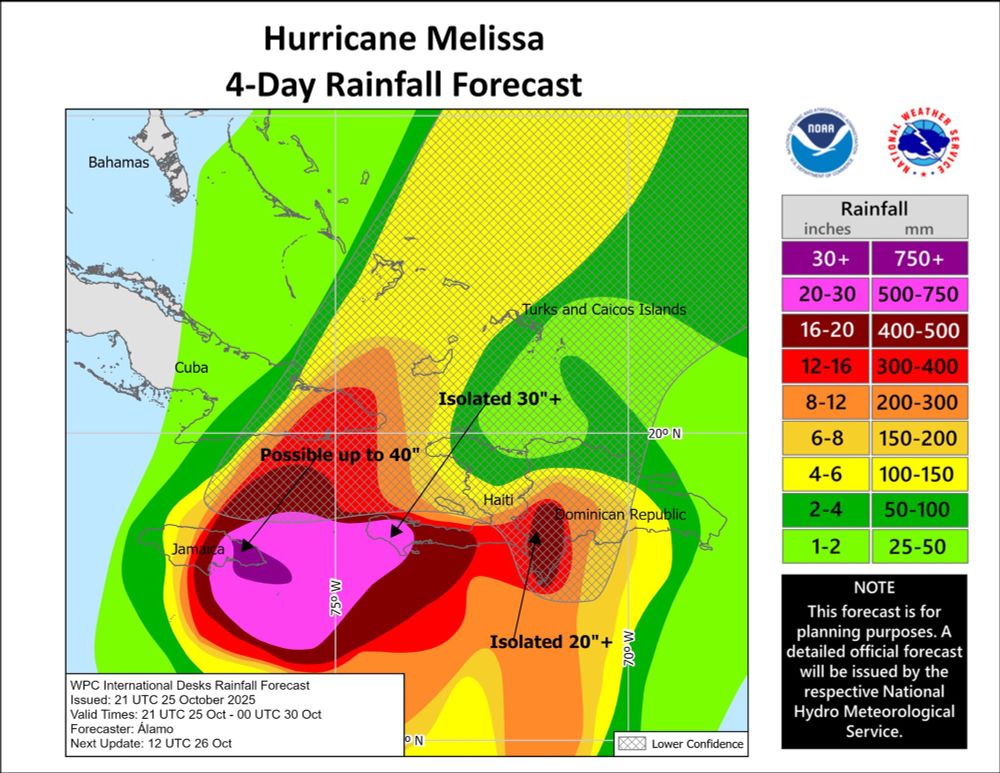
Melissa is about to rapidly intensify into a major hurricane over the next 12h. An eye has become more apparent on satellite imagery, with strong VHTs rotating around the eyewall. Melissa is now forecast to produce isolated areas over 40 INCHES of rain in E Jamaica.

October 25, 2025 at 8:27 PM
Melissa is about to rapidly intensify into a major hurricane over the next 12h. An eye has become more apparent on satellite imagery, with strong VHTs rotating around the eyewall. Melissa is now forecast to produce isolated areas over 40 INCHES of rain in E Jamaica.