NWS Boston/Norton SKYWARN Amateur Radio Station - WX1BOX
wx1box.bsky.social
NWS Boston/Norton SKYWARN Amateur Radio Station - WX1BOX
@wx1box.bsky.social
Amateur Radio Station at the NWS office in Boston/Norton Mass providing Skywarn Reports
Additional strong wind gusts this PM into early evening. #mawx #riwx #ctwx
November 16, 2025 at 10:55 PM
Strong wind gusts with passing cold front Sunday late AM/early PM. #mawx #riwx #ctwx
November 16, 2025 at 6:52 PM
Here are some of additional strong wind gusts along the coast from last night into early Wed AM. Also, monitoring for any snowfall reports in Western Mass from yesterday and this morning. #mawx #riwx #ctwx
November 12, 2025 at 2:09 PM
Here are some strong wind gusts greater than 40 MPH in the area from this PM/early evening. #mawx #riwx
November 11, 2025 at 11:49 PM
Here is a rain gauge and wind gust summary from this Sunday Evening thunderstorm/heavy downpour event. A few flooding reports were also received from the heavy rainfall where at least the heaviest rain missed the urbanized areas more prone to flooding. #mawx #riwx
November 10, 2025 at 1:19 AM
Here is a listing of strong wind gusts from the overnight period late Wednesday Evening to early Thursday AM. #mawx #riwx #ctwx
November 6, 2025 at 11:58 AM
It has been a busy time between the strong wind gusts for today and the strong to damaging winds and convective showers and tstorms of monday nite. Coordination msg to be posted later tonite on late wed nite into Thursday AM damaging wind potential. #mawx #riwx #ctwx
November 5, 2025 at 12:37 AM
Strong Wind Gusts from Tuesday AM - 11/4/25 #mawx #riwx #ctwx
November 4, 2025 at 5:03 PM
Here is a list of peak wind gusts for Friday 10/31/25 after the first round of winds Thursday Night into the early Friday AM hours. We have a number of reports of pockets of trees/wires down with an uptick in the reporting over the last 2-3 hours. #mawx #riwx #ctwx
November 1, 2025 at 1:49 AM
Cape & Islands WX Net Amateur Radio Wx Net reports. Note that the net's radio coverage can cover areas outside of the Cape and Islands. #mawx
October 13, 2025 at 10:28 AM
Updated Rain Gauge Totals from the region with areas of moderate to heavy rain in parts of Northeast CT, RI & Southeast Mass. #mawx #riwx #ctwx
September 24, 2025 at 2:51 PM
On This Day in Weather History: September 21, 1938.

The Hurricane of 1938 was one of the most destructive storms that struck southern New England.

More info:
www.weather.gov/box/1938hurr...
September 22, 2025 at 2:14 AM
Some of the more interesting rain gauge totals from Tuesday PM to Wednesday AM with a few higher amounts in Southeast Mass. #mawx
September 18, 2025 at 12:17 PM
Here are some of the higher end rain gauge totals received on Friday 8/29/25 from parts of SNE. #mawx #riwx #ctwx
August 30, 2025 at 2:39 AM
From the 1000-1010 AM timeframe - Billy Lescault - Warwick, RI - Hail up to Dime sized #riwx
August 29, 2025 at 3:26 PM
With credit to Beth Poudrier Forbush and the Dave Hayes The Weather Nut Facebook page, here is a video of a Waterspout betweeen Manomet and Provincetown MA from Wednesday 8/27/25 around 410 PM. #mawx
August 29, 2025 at 12:46 AM
Some of the higher end rain gauge totals received across portions of SNE from the Wednesday 8/20/25-Thursday AM 8/21/25 rain event. #mawx #riwx #ctwx
August 21, 2025 at 12:39 PM
Some impressive rain gauge totals in SNE - Wednesday 8/20/25. #mawx #riwx #ctwx
August 21, 2025 at 3:03 AM
A beautiful day for most but some rain gauge totals from downpours and general tstorms Saturday PM in portions of Western Massachusetts. #mawx
August 17, 2025 at 12:39 AM
Thursday Evening 8/14/25 - Severe Thunderstorm Event - Bartlett Road - Randolph MA - Photo credit: Dewey Schramm via KC1KWC-Rob Millete. #mawx
August 15, 2025 at 3:15 PM
Randolph, MA - Clark Street Photo by: Dewey Schramm #mawx
August 15, 2025 at 2:20 AM
KW1TWL-Jim Ashley-Auburn St Whitman MA - 2 Trees down - Thursday 8/14/25 - Severe Tstorm event. #mawx
August 15, 2025 at 1:30 AM
Rain Gauge Reports from isolated to scattered strong to severe tstorms in SNE - Wednesday 8/13/25. #mawx
August 14, 2025 at 1:17 AM
Coordination message to be posted this morning on severe weather potential for much of Southern New England along and north/west of I95 for Wednesday PM and evening. #mawx #riwx #ctwx
August 13, 2025 at 10:48 AM
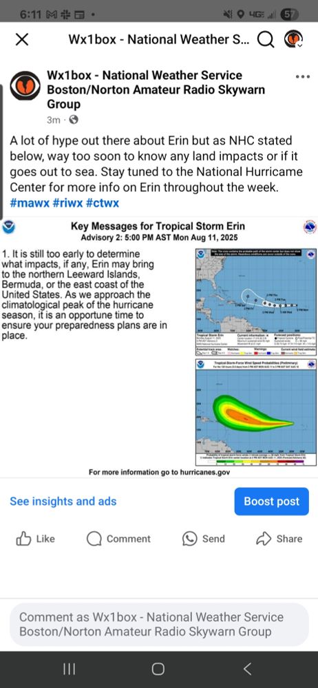
A lot of hype out there about Erin but as NHC stated below, way too soon to know any land impacts or if it goes out to sea. Stay tuned to NHC for more info on Erin throughout the week. #mawx #riwx #ctwx
August 11, 2025 at 10:12 PM