


Tim Sherratt
@wragge.hcommons.social.ap.brid.gy
I’m a historian and hacker who researches the possibilities and politics of digital cultural collections.
My main project at the moment is the #GLAMWorkbench […]
🌉 bridged from https://hcommons.social/@wragge on the fediverse by https://fed.brid.gy/
My main project at the moment is the #GLAMWorkbench […]
🌉 bridged from https://hcommons.social/@wragge on the fediverse by https://fed.brid.gy/
And now in a database so I can do place and distance queries...

November 18, 2025 at 1:14 PM
And now in a database so I can do place and distance queries...
A few thousand newspapers from SLV geolocated by place of publication/distribution. This includes digitised and non-digitised titles.

November 18, 2025 at 4:34 AM
A few thousand newspapers from SLV geolocated by place of publication/distribution. This includes digitised and non-digitised titles.
Starting to bring various bits of my #slvresidency together in a new prototype...

November 15, 2025 at 6:36 AM
Starting to bring various bits of my #slvresidency together in a new prototype...
Gippsland map lovers have joined the party. https://wragge.github.io/slv-allmaps/dashboard.html

November 12, 2025 at 10:43 AM
Gippsland map lovers have joined the party. https://wragge.github.io/slv-allmaps/dashboard.html

November 8, 2025 at 4:25 AM
We've hit the hundred mark!!

November 2, 2025 at 4:33 AM
We've hit the hundred mark!!
Help me turn the State Library Victoria's digitised maps into data!
As part of my residency at the SLV LAB, I've been experimenting with using Allmaps and @IIIF to georeference the Library's maps. Georeferencing relates a digitised map to real world […]
[Original post on hcommons.social]
As part of my residency at the SLV LAB, I've been experimenting with using Allmaps and @IIIF to georeference the Library's maps. Georeferencing relates a digitised map to real world […]
[Original post on hcommons.social]

October 30, 2025 at 11:51 PM
Help me turn the State Library Victoria's digitised maps into data!
As part of my residency at the SLV LAB, I've been experimenting with using Allmaps and @IIIF to georeference the Library's maps. Georeferencing relates a digitised map to real world […]
[Original post on hcommons.social]
As part of my residency at the SLV LAB, I've been experimenting with using Allmaps and @IIIF to georeference the Library's maps. Georeferencing relates a digitised map to real world […]
[Original post on hcommons.social]
Help me turn the State Library of Victoria's digitised maps into data! https://wragge.github.io/slv-allmaps/ (bit of a soft launch, so let me know if you see any errors in the documentation...)

October 30, 2025 at 5:47 AM
Help me turn the State Library of Victoria's digitised maps into data! https://wragge.github.io/slv-allmaps/ (bit of a soft launch, so let me know if you see any errors in the documentation...)
Feeling a bit pleased with this latest prototype for my #slvresidency – it's a userscript that adds links to georeference digitised maps in the SLV collection using AllMaps. If an item has already been georeferenced it embed the AllMaps viewer to show the […]
[Original post on hcommons.social]
[Original post on hcommons.social]

October 28, 2025 at 1:41 AM
Feeling a bit pleased with this latest prototype for my #slvresidency – it's a userscript that adds links to georeference digitised maps in the SLV collection using AllMaps. If an item has already been georeferenced it embed the AllMaps viewer to show the […]
[Original post on hcommons.social]
[Original post on hcommons.social]
We said goodbye to this beautiful girl today...


October 22, 2025 at 6:22 AM
We said goodbye to this beautiful girl today...
Ok, next step for the SLV Committee for Urban Action photos – I've finally managed to get them loaded into a sqlite/spacialite db, so I can run spatial queries like finding the number of photographed roads within a given radius from a point.

October 22, 2025 at 12:05 AM
Ok, next step for the SLV Committee for Urban Action photos – I've finally managed to get them loaded into a sqlite/spacialite db, so I can run spatial queries like finding the number of photographed roads within a given radius from a point.
New prototype from my #slvresidency! This one lets you explore photos from the Committee for Urban Action collection by selecting one of the highlighted roads on a map of Victoria. It's very much work-in-progress and will probably change a lot, but you can […]
[Original post on hcommons.social]
[Original post on hcommons.social]

October 20, 2025 at 6:57 AM
New prototype from my #slvresidency! This one lets you explore photos from the Committee for Urban Action collection by selecting one of the highlighted roads on a map of Victoria. It's very much work-in-progress and will probably change a lot, but you can […]
[Original post on hcommons.social]
[Original post on hcommons.social]
Found my mum and dad in the midst of building their first house in 1955 in Beaumaris... (and yes, built with their own hands)

October 17, 2025 at 10:58 AM
Found my mum and dad in the midst of building their first house in 1955 in Beaumaris... (and yes, built with their own hands)
Almost got a simple prototype for the CUA photos as well...

October 17, 2025 at 8:19 AM
Almost got a simple prototype for the CUA photos as well...
So that seems to be working... Online soon!
October 17, 2025 at 7:49 AM
So that seems to be working... Online soon!
Hey Clunes, just wondering why this road has four different names within the space of a few hundred metres...

October 14, 2025 at 2:43 AM
Hey Clunes, just wondering why this road has four different names within the space of a few hundred metres...
An example of some of the regional towns -- Castlemaine/Chewton.

October 11, 2025 at 6:23 AM
An example of some of the regional towns -- Castlemaine/Chewton.
First run of processing the SLV's 20,000+ digitised photos from the Committee for Urban Action to link them to geolocated road segments. A few oddities to investigate, but pretty good. Fitzroy and South Melbourne have been digitised, and a number of the goldfields towns, more will be added soon.

October 11, 2025 at 6:20 AM
First run of processing the SLV's 20,000+ digitised photos from the Committee for Urban Action to link them to geolocated road segments. A few oddities to investigate, but pretty good. Fitzroy and South Melbourne have been digitised, and a number of the goldfields towns, more will be added soon.
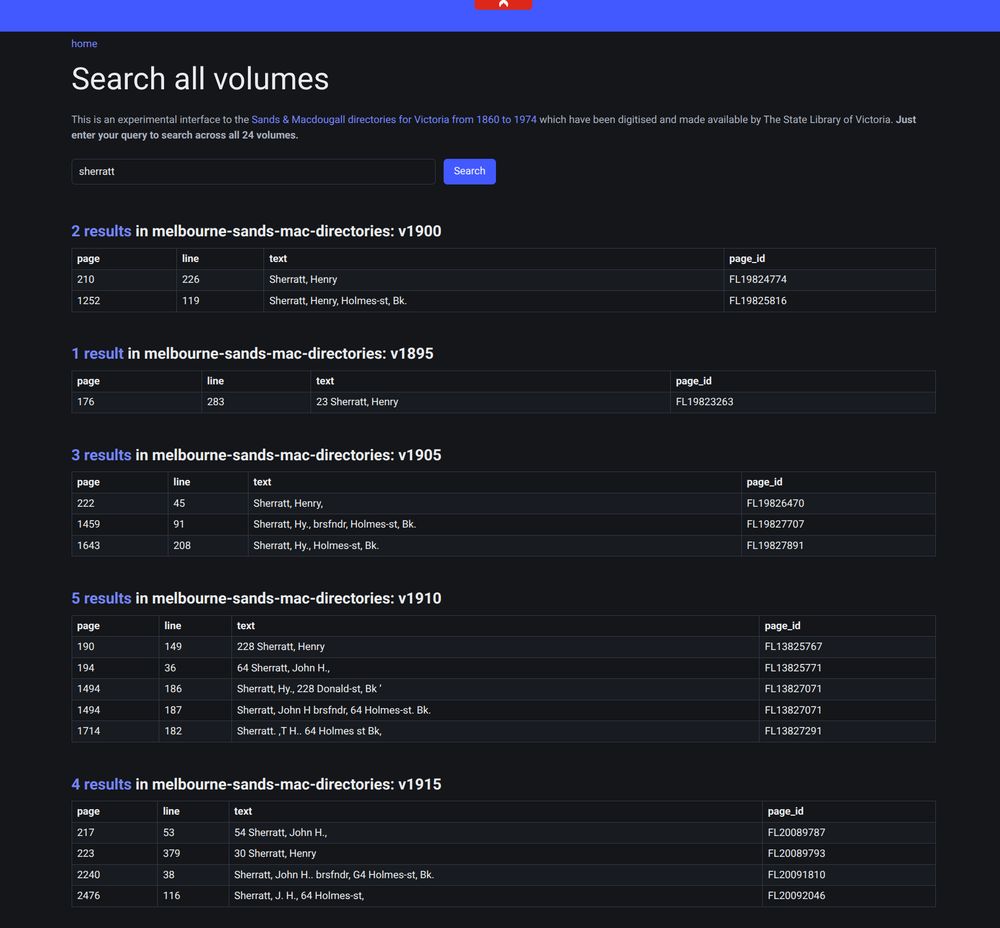
More Tesseract tweaking -- I wasn't happy with the way the gap after runs of the same surname was being treated as a column divider, separating the name parts. Trawling through Tesseract's billions of config options I came across […]
[Original post on hcommons.social]
[Original post on hcommons.social]

October 9, 2025 at 11:29 AM
More Tesseract tweaking -- I wasn't happy with the way the gap after runs of the same surname was being treated as a column divider, separating the name parts. Trawling through Tesseract's billions of config options I came across […]
[Original post on hcommons.social]
[Original post on hcommons.social]

Spotlight sure has changed...

October 2, 2025 at 6:53 AM
Spotlight sure has changed...
Today in my #slvresidency I created a userscript that adds links to Wikimedia Commons to the SLV image viewer if the image has been uploaded to the Commons (and the handle url is in the metadata). You can then see if the item has been used in other Wiki […]
[Original post on hcommons.social]
[Original post on hcommons.social]

September 29, 2025 at 6:47 AM
Today in my #slvresidency I created a userscript that adds links to Wikimedia Commons to the SLV image viewer if the image has been uploaded to the Commons (and the handle url is in the metadata). You can then see if the item has been used in other Wiki […]
[Original post on hcommons.social]
[Original post on hcommons.social]
For my #slvresidency I've been working on a way to geolocate these road segments, so we can link the photos to their locations. I've now got a proof of concept working! I just downloaded the first 200 results from Fitzroy and ran them through. Here's the road segments linked to SLV records on a map.

September 27, 2025 at 7:52 AM
For my #slvresidency I've been working on a way to geolocate these road segments, so we can link the photos to their locations. I've now got a proof of concept working! I just downloaded the first 200 results from Fitzroy and ran them through. Here's the road segments linked to SLV records on a map.
And now it's handling changed suburb boundaries. In this case the street is no longer in Eaglehawk, so it zooms out to try city, municipality, state until it finds something. It finds it in Bendigo.

September 27, 2025 at 6:27 AM
And now it's handling changed suburb boundaries. In this case the street is no longer in Eaglehawk, so it zooms out to try city, municipality, state until it finds something. It finds it in Bendigo.
And now it's getting road segments that start or end at a roundabout (roundabouts are a break in the roads so there aren't any intersecting nodes -- I had to find the node in street a that was closest to street b).

September 27, 2025 at 4:55 AM
And now it's getting road segments that start or end at a roundabout (roundabouts are a break in the roads so there aren't any intersecting nodes -- I had to find the node in street a that was closest to street b).