


Weather Now- Kentucky
@wnkwx.bsky.social
Kentucky's Weather Team! Get the earliest heads up, latest real time weather alerts and more from the team made of real Kentuckians that care for you!
Sloppy Sunday as rains won't exit until the late morning for most.
* Visit FBibuildings.com for any pole barn renovation or from scratch project. They've served Kentucky for over 60 years! Let them take care of you too! - George
* Visit FBibuildings.com for any pole barn renovation or from scratch project. They've served Kentucky for over 60 years! Let them take care of you too! - George

December 15, 2024 at 1:15 AM
Sloppy Sunday as rains won't exit until the late morning for most.
* Visit FBibuildings.com for any pole barn renovation or from scratch project. They've served Kentucky for over 60 years! Let them take care of you too! - George
* Visit FBibuildings.com for any pole barn renovation or from scratch project. They've served Kentucky for over 60 years! Let them take care of you too! - George
Rain will dominate the state by the afternoon. Late into the evening, some rain showers may transition to weak Thunderstorms.- George

December 14, 2024 at 12:23 AM
Rain will dominate the state by the afternoon. Late into the evening, some rain showers may transition to weak Thunderstorms.- George
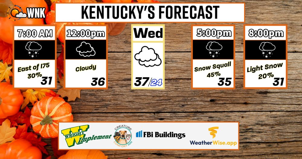
On Wednesday, snow is possible in the early morning for areas EAST of I75. In the afternoon/evening snow squalls (small bursts of snowfall) are possible for Central & East Kentucky. Temperatures CRASH for ALL overnight into Thursday. -George
December 11, 2024 at 1:27 AM
On Wednesday, snow is possible in the early morning for areas EAST of I75. In the afternoon/evening snow squalls (small bursts of snowfall) are possible for Central & East Kentucky. Temperatures CRASH for ALL overnight into Thursday. -George
Minor Snow accumulations expected from a couple different waves of Snow on Wednesday. Please read more of the information below and be on the look out for updates.- George


December 10, 2024 at 1:05 AM
Minor Snow accumulations expected from a couple different waves of Snow on Wednesday. Please read more of the information below and be on the look out for updates.- George
2:25pm ET:
West Kentucky mostly missed the last snow, they sure aren't today! - George
West Kentucky mostly missed the last snow, they sure aren't today! - George

December 2, 2024 at 7:27 PM
2:25pm ET:
West Kentucky mostly missed the last snow, they sure aren't today! - George
West Kentucky mostly missed the last snow, they sure aren't today! - George
Latest thinking from the NAM model regarding snowfall today. Only grassy accumulations expected. Most roads will be fine, but their may be brief periods of slick spots after sunsets. For those asking, YES Schools will most likely be allowed to safely operate tomorrow.- George

December 2, 2024 at 6:12 PM
Latest thinking from the NAM model regarding snowfall today. Only grassy accumulations expected. Most roads will be fine, but their may be brief periods of slick spots after sunsets. For those asking, YES Schools will most likely be allowed to safely operate tomorrow.- George
A light coating of snow is possible tomorrow evening as flurries and some light snow showers move through the commonwealth. A VERY cold day, wind chills will make it feel more like January outside.
- George
- George
December 2, 2024 at 12:24 AM
A light coating of snow is possible tomorrow evening as flurries and some light snow showers move through the commonwealth. A VERY cold day, wind chills will make it feel more like January outside.
- George
- George
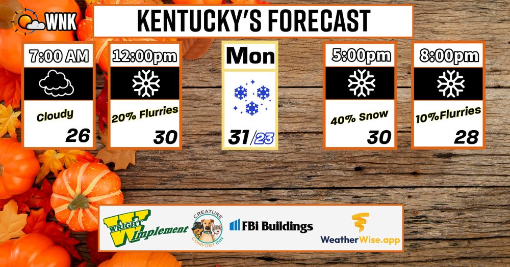
Monday morning through evening, light snows will flurry through much of Kentucky. This is not expected to be a big event, by any means. More festive than anything. A few slick spots may arise by Monday evening if a few heavier down bursts occur but overall, a mainly harmless snow maker. - George

December 1, 2024 at 10:25 PM
Monday morning through evening, light snows will flurry through much of Kentucky. This is not expected to be a big event, by any means. More festive than anything. A few slick spots may arise by Monday evening if a few heavier down bursts occur but overall, a mainly harmless snow maker. - George
As always, here's the after storm report:
~ We've taken verified reports from NWS, IEM, and Pivotal Weather to place amounts overtop of our forecast. Our forecast scores a 92% (2 out of 25 reports were either higher or lower than the forecasted range... 23 out of 25 were within the range. - George
~ We've taken verified reports from NWS, IEM, and Pivotal Weather to place amounts overtop of our forecast. Our forecast scores a 92% (2 out of 25 reports were either higher or lower than the forecasted range... 23 out of 25 were within the range. - George

December 1, 2024 at 5:05 PM
As always, here's the after storm report:
~ We've taken verified reports from NWS, IEM, and Pivotal Weather to place amounts overtop of our forecast. Our forecast scores a 92% (2 out of 25 reports were either higher or lower than the forecasted range... 23 out of 25 were within the range. - George
~ We've taken verified reports from NWS, IEM, and Pivotal Weather to place amounts overtop of our forecast. Our forecast scores a 92% (2 out of 25 reports were either higher or lower than the forecasted range... 23 out of 25 were within the range. - George
Here's the updated and final call for Snow Accumulations today and overnight. I want to preface this by saying, clippers like this have a history of over performing in some locations and underperforming in others. Let's do a LIVE broadcast soon to go over the newest details! - George

November 30, 2024 at 2:38 PM
Here's the updated and final call for Snow Accumulations today and overnight. I want to preface this by saying, clippers like this have a history of over performing in some locations and underperforming in others. Let's do a LIVE broadcast soon to go over the newest details! - George
The latest on the Alert Day for todays snowfall. - George

November 30, 2024 at 1:56 PM
The latest on the Alert Day for todays snowfall. - George
Snowy Saturday in Kentucky! Be sure to view our broadcast from earlier via YT or Facebook for all of the info.
* Stay warm this cold Winter with outdoor apparel from Wright Implement. Support WNK and local business when you shop with Wright Implement!!! - George
* Stay warm this cold Winter with outdoor apparel from Wright Implement. Support WNK and local business when you shop with Wright Implement!!! - George

November 30, 2024 at 2:22 AM
Snowy Saturday in Kentucky! Be sure to view our broadcast from earlier via YT or Facebook for all of the info.
* Stay warm this cold Winter with outdoor apparel from Wright Implement. Support WNK and local business when you shop with Wright Implement!!! - George
* Stay warm this cold Winter with outdoor apparel from Wright Implement. Support WNK and local business when you shop with Wright Implement!!! - George
~ On Saturday a clipper style snow event will push through Kentucky between 1pm-3am ET. More details will be provided during our LIVE broadcast around 9pm ET, tonight on Facebook & YouTube.

November 29, 2024 at 8:18 PM
~ On Saturday a clipper style snow event will push through Kentucky between 1pm-3am ET. More details will be provided during our LIVE broadcast around 9pm ET, tonight on Facebook & YouTube.
Accumulating Snow will lead to travel concerns Saturday evening into Sunday morning. Alert Status is being raised for these implications to travel. Our first call for snowfall will be posted shortly. Additionally, a LIVE Broadcast will air tonight at 9pm ET. - George

November 29, 2024 at 5:44 PM
Accumulating Snow will lead to travel concerns Saturday evening into Sunday morning. Alert Status is being raised for these implications to travel. Our first call for snowfall will be posted shortly. Additionally, a LIVE Broadcast will air tonight at 9pm ET. - George
❄: This weekend, a light accumulating snow is possible. We'll start forecasting this more tomorrow evening (that's when better short range models start to see the weekend). For now, it's just a mere heads up! - George

November 28, 2024 at 1:30 AM
❄: This weekend, a light accumulating snow is possible. We'll start forecasting this more tomorrow evening (that's when better short range models start to see the weekend). For now, it's just a mere heads up! - George
The cold front begins on Tuesday...
* Keep your pets warm and full of joy when you travel away from home... Book them a stay at the Creature Comfort Inn! Your pet deserves a fun holiday break too. - George
* Keep your pets warm and full of joy when you travel away from home... Book them a stay at the Creature Comfort Inn! Your pet deserves a fun holiday break too. - George

November 26, 2024 at 12:28 AM
The cold front begins on Tuesday...
* Keep your pets warm and full of joy when you travel away from home... Book them a stay at the Creature Comfort Inn! Your pet deserves a fun holiday break too. - George
* Keep your pets warm and full of joy when you travel away from home... Book them a stay at the Creature Comfort Inn! Your pet deserves a fun holiday break too. - George
The updated Coffee Scale for those who follow!

November 25, 2024 at 4:08 PM
The updated Coffee Scale for those who follow!
Wow, maybe one of the easiest forecasts we've ever put out!
* It's also easy to support Wright Implement, with 15 locations across Kentuckians. Support Kentucky businesses and get your Winter equipment and outdoor apparel from Wright Implement! - George
* It's also easy to support Wright Implement, with 15 locations across Kentuckians. Support Kentucky businesses and get your Winter equipment and outdoor apparel from Wright Implement! - George

November 23, 2024 at 1:12 AM
Wow, maybe one of the easiest forecasts we've ever put out!
* It's also easy to support Wright Implement, with 15 locations across Kentuckians. Support Kentucky businesses and get your Winter equipment and outdoor apparel from Wright Implement! - George
* It's also easy to support Wright Implement, with 15 locations across Kentuckians. Support Kentucky businesses and get your Winter equipment and outdoor apparel from Wright Implement! - George
A much less eventful Friday. Only a brief mix expected in the afternoon in FAR East Kentucky. If you see snow late tonight, expect your temperature to be 2-3 degrees colder at 7am than what's shown.
* Download the all new, free, fast rising Weather Radar app, WeatherWise! - George
* Download the all new, free, fast rising Weather Radar app, WeatherWise! - George

November 22, 2024 at 1:25 AM
A much less eventful Friday. Only a brief mix expected in the afternoon in FAR East Kentucky. If you see snow late tonight, expect your temperature to be 2-3 degrees colder at 7am than what's shown.
* Download the all new, free, fast rising Weather Radar app, WeatherWise! - George
* Download the all new, free, fast rising Weather Radar app, WeatherWise! - George
Folks in Western Kentucky have to be thinking the rest of Kentucky is crazy with this snow talk. I mean, LOOK at that temperature difference at the 3pm ET hour. Temp map via Kentucky Mesonet! - George

November 21, 2024 at 7:47 PM
Folks in Western Kentucky have to be thinking the rest of Kentucky is crazy with this snow talk. I mean, LOOK at that temperature difference at the 3pm ET hour. Temp map via Kentucky Mesonet! - George
ICYMI: Here's our final snow call for Thursday. Additional snow showers are possible Friday for far East KY, but we'll cover that tomorrow. Weaker snow showers in the morning, more widespread snow by the evening. - George

November 21, 2024 at 1:17 AM
ICYMI: Here's our final snow call for Thursday. Additional snow showers are possible Friday for far East KY, but we'll cover that tomorrow. Weaker snow showers in the morning, more widespread snow by the evening. - George
UPDATED Snow Accumulations:
~ More details on timing (there may be a few different waves over a 24 hour period) will be posted later.
~ Here's the latest thinking on accumulation. A festive dusting for most along & East of I65, but 2-4" is possible in the higher terrain of SE KY. - George
~ More details on timing (there may be a few different waves over a 24 hour period) will be posted later.
~ Here's the latest thinking on accumulation. A festive dusting for most along & East of I65, but 2-4" is possible in the higher terrain of SE KY. - George

November 20, 2024 at 4:51 PM
UPDATED Snow Accumulations:
~ More details on timing (there may be a few different waves over a 24 hour period) will be posted later.
~ Here's the latest thinking on accumulation. A festive dusting for most along & East of I65, but 2-4" is possible in the higher terrain of SE KY. - George
~ More details on timing (there may be a few different waves over a 24 hour period) will be posted later.
~ Here's the latest thinking on accumulation. A festive dusting for most along & East of I65, but 2-4" is possible in the higher terrain of SE KY. - George
Here comes the 15-30mph wind gusts. We'll keep these through Friday, off and on. - George
November 20, 2024 at 1:44 PM
Here comes the 15-30mph wind gusts. We'll keep these through Friday, off and on. - George
NOTE: Visibilities will be greatly impacted by Dense fog across Central Kentucky overnight and into the morning. - George
November 20, 2024 at 4:49 AM
NOTE: Visibilities will be greatly impacted by Dense fog across Central Kentucky overnight and into the morning. - George
On Wednesday, a COLD front dives in by late afternoon and really TANKS temps by the overnight. Some light/spotty showers are possible as the cold front settles in. This sets the stage for our SNOW chances on Thursday & Friday.

November 20, 2024 at 2:10 AM
On Wednesday, a COLD front dives in by late afternoon and really TANKS temps by the overnight. Some light/spotty showers are possible as the cold front settles in. This sets the stage for our SNOW chances on Thursday & Friday.