


Scott Bachmeier
@wisc-satellite.bsky.social
Satellite meteorologist, NOAA Cooperative Institute for Meteorological Satellite Studies, University of Wisconsin - Madison. Personal account, all opinions ©2025. https://cimss.ssec.wisc.edu/satellite-blog/archives/author/scottb
A thermal signature of the #BlueOrigin #NewGlenn #NG2 booster rocket was apparent in @NOAASatellites #GOESEast ABI spectral bands 8/9/10/16 (w/ a very subtle signature in Band 4) as it launched from @NASAKennedy in Florida. A signature of the rocket condensation cloud was seen in all 16 ABI Bands.
November 13, 2025 at 10:43 PM
A thermal signature of the #BlueOrigin #NewGlenn #NG2 booster rocket was apparent in @NOAASatellites #GOESEast ABI spectral bands 8/9/10/16 (w/ a very subtle signature in Band 4) as it launched from @NASAKennedy in Florida. A signature of the rocket condensation cloud was seen in all 16 ABI Bands.
1-min #GOESEast Infrared images w/ an overlay of GLM Flash Extent Density (large blue/cyan pixels) & GLM Flash Points (white dots) showed 3 brief signatures of lightning along the Indiana & Illinois coasts overnight - highlighting lake effect thundersnow. @nwschicago.bsky.social #ILwx #INwx
November 10, 2025 at 4:56 PM
1-min #GOESEast Infrared images w/ an overlay of GLM Flash Extent Density (large blue/cyan pixels) & GLM Flash Points (white dots) showed 3 brief signatures of lightning along the Indiana & Illinois coasts overnight - highlighting lake effect thundersnow. @nwschicago.bsky.social #ILwx #INwx
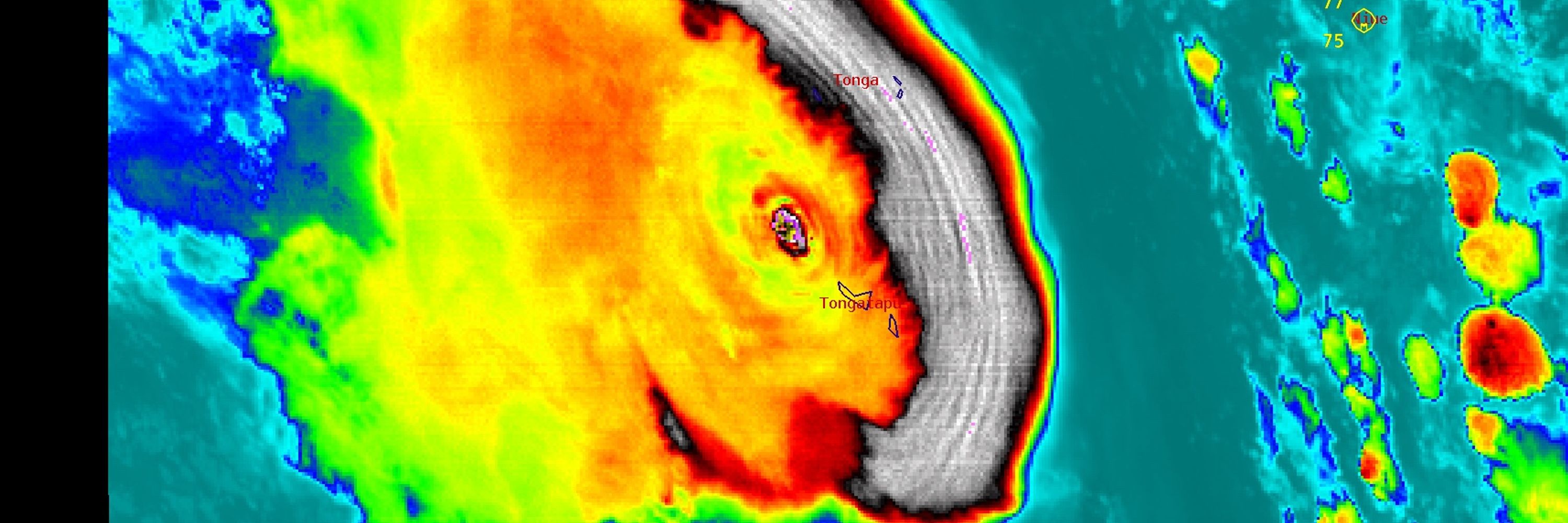
Super Typhoon Haiyan certainly had an impressive presentation in satellite imagery: cimss.ssec.wisc.edu/satellite-bl...
November 8, 2025 at 4:31 PM
Super Typhoon Haiyan certainly had an impressive presentation in satellite imagery: cimss.ssec.wisc.edu/satellite-bl...
lLooks like the resuspension has not been suspended.
November 7, 2025 at 11:12 PM
lLooks like the resuspension has not been suspended.
Is this from yesterday's event, or is the event still ongoing?
November 7, 2025 at 10:14 PM
Is this from yesterday's event, or is the event still ongoing?
A thermal signature of the UPS Flight 2978 crash and resulting fire near Louisville International Airport (on November 4) was evident in both #GOESEast and #GOESWest, especially using the Next Generation Fire System -- details on the CIMSS Satellite Blog: cimss.ssec.wisc.edu/satellite-bl...
November 6, 2025 at 11:52 PM
A thermal signature of the UPS Flight 2978 crash and resulting fire near Louisville International Airport (on November 4) was evident in both #GOESEast and #GOESWest, especially using the Next Generation Fire System -- details on the CIMSS Satellite Blog: cimss.ssec.wisc.edu/satellite-bl...
True Color RGB images from #GOES19/#GOESEast showed the rapidly intensifying Hurricane Force Low south of the Canadian Maritimes -- which included the hazy signature of light being scattered by very high waves south-southeast of the storm center. @cyclone-fogarty.bsky.social
November 4, 2025 at 10:38 PM
True Color RGB images from #GOES19/#GOESEast showed the rapidly intensifying Hurricane Force Low south of the Canadian Maritimes -- which included the hazy signature of light being scattered by very high waves south-southeast of the storm center. @cyclone-fogarty.bsky.social
After briefly intensifying to a Category 4 storm at 0300 UTC (between Jamaica and Cuba), Hurricane #Melissa later made landfall in Cuba as a Category 3 storm at 0710 UTC. The peak wind gust at Guantanamo (MUGM) was 75 kts (86 mph) at 0623 UTC.
October 29, 2025 at 5:12 PM
After briefly intensifying to a Category 4 storm at 0300 UTC (between Jamaica and Cuba), Hurricane #Melissa later made landfall in Cuba as a Category 3 storm at 0710 UTC. The peak wind gust at Guantanamo (MUGM) was 75 kts (86 mph) at 0623 UTC.
1-minute #GOES19/#GOESEast Visible images showed that soon after making landfall, the eye of Hurricane #Melissa became cloud-filled as the storm interacted with higher terrain on the western edge of Jamaica.
October 28, 2025 at 8:58 PM
1-minute #GOES19/#GOESEast Visible images showed that soon after making landfall, the eye of Hurricane #Melissa became cloud-filled as the storm interacted with higher terrain on the western edge of Jamaica.
1-minute #GOES19/#GOESEast Visible and Infrared images with plots of GLM Flash Points showed prolific lightning activity within the inner eyewall of Category 5 Hurricane #Melissa as it approaches the SW coast of Jamaica. Low-altitude mesovortices persist within the eye.
October 28, 2025 at 2:32 PM
1-minute #GOES19/#GOESEast Visible and Infrared images with plots of GLM Flash Points showed prolific lightning activity within the inner eyewall of Category 5 Hurricane #Melissa as it approaches the SW coast of Jamaica. Low-altitude mesovortices persist within the eye.
Sunrise on Category 5 Hurricane #Melissa south of Jamaica -- 1-minute #GOES19/#GOESEast Visible and Infrared images showed a nice "stadium effect" with the eye, and GLM Flash Points highlighted abundant lightning activity within the inner eyewall.
October 27, 2025 at 5:02 PM
Sunrise on Category 5 Hurricane #Melissa south of Jamaica -- 1-minute #GOES19/#GOESEast Visible and Infrared images showed a nice "stadium effect" with the eye, and GLM Flash Points highlighted abundant lightning activity within the inner eyewall.
More imagery and details of Hurricane #Melissa are available on the CIMSS Satellite Blog: cimss.ssec.wisc.edu/satellite-bl...
October 27, 2025 at 3:45 AM
More imagery and details of Hurricane #Melissa are available on the CIMSS Satellite Blog: cimss.ssec.wisc.edu/satellite-bl...
1-minute Mesoscale Sector #GOES19/#GOESEast Infrared images + GLM Flash Points showed #Melissa as it intensified from a Tropical Storm to a Hurricane at 1800 UTC. Since that time, a large convective burst developed and wrapped around the eastern semicircle of the hurricane.
October 25, 2025 at 9:52 PM
1-minute Mesoscale Sector #GOES19/#GOESEast Infrared images + GLM Flash Points showed #Melissa as it intensified from a Tropical Storm to a Hurricane at 1800 UTC. Since that time, a large convective burst developed and wrapped around the eastern semicircle of the hurricane.
ICYMI, satellite signatures of the SpaceX Starship Test Flight 11 on Monday evening (13 October) can be seen on the CIMSS Satellite Blog: cimss.ssec.wisc.edu/satellite-bl...
October 15, 2025 at 5:17 PM
ICYMI, satellite signatures of the SpaceX Starship Test Flight 11 on Monday evening (13 October) can be seen on the CIMSS Satellite Blog: cimss.ssec.wisc.edu/satellite-bl...