


WhitePhosphorus.info
@whitephosphorus.info
A spatial archive of 248 verified and geolocated white phosphorus strikes across South Lebanon (2023–2024). Explore the archive on: whitephosphorus.info
Developed as part of the PhD research of @baydoun.nl
Developed as part of the PhD research of @baydoun.nl
White phosphorus is not explicitly banned, but its use near civilians violates international humanitarian law.
Our findings show its use in Lebanon was systematic rather than driven by military necessity, causing environmental and civilian harm.
Explore: whitephosphorus.info
Our findings show its use in Lebanon was systematic rather than driven by military necessity, causing environmental and civilian harm.
Explore: whitephosphorus.info

White Phosphorus
Geolocating, mapping, and documenting Israeli military's use of white phosphorus in Lebanon between 2023 and 2024.
whitephosphorus.info
November 11, 2025 at 3:43 PM
White phosphorus is not explicitly banned, but its use near civilians violates international humanitarian law.
Our findings show its use in Lebanon was systematic rather than driven by military necessity, causing environmental and civilian harm.
Explore: whitephosphorus.info
Our findings show its use in Lebanon was systematic rather than driven by military necessity, causing environmental and civilian harm.
Explore: whitephosphorus.info
Sometimes the same white phosphorus strike was captured from different cameras and angles. In some cases even from across the Israel–Lebanon border, as with WP100 shown here.
This makes geolocating each photographer’s point of view important to avoid double counting.
This makes geolocating each photographer’s point of view important to avoid double counting.

November 11, 2025 at 3:43 PM
Sometimes the same white phosphorus strike was captured from different cameras and angles. In some cases even from across the Israel–Lebanon border, as with WP100 shown here.
This makes geolocating each photographer’s point of view important to avoid double counting.
This makes geolocating each photographer’s point of view important to avoid double counting.
Access to daily satellite imagery significantly helped in geolocating, chronolocating, and assessing the burn marks of each strike.
In some cases, no visible trace remained, especially under humid conditions or within urban areas.
(Imagery shown of WP112 from Planet Labs)
In some cases, no visible trace remained, especially under humid conditions or within urban areas.
(Imagery shown of WP112 from Planet Labs)
November 11, 2025 at 3:42 PM
Access to daily satellite imagery significantly helped in geolocating, chronolocating, and assessing the burn marks of each strike.
In some cases, no visible trace remained, especially under humid conditions or within urban areas.
(Imagery shown of WP112 from Planet Labs)
In some cases, no visible trace remained, especially under humid conditions or within urban areas.
(Imagery shown of WP112 from Planet Labs)
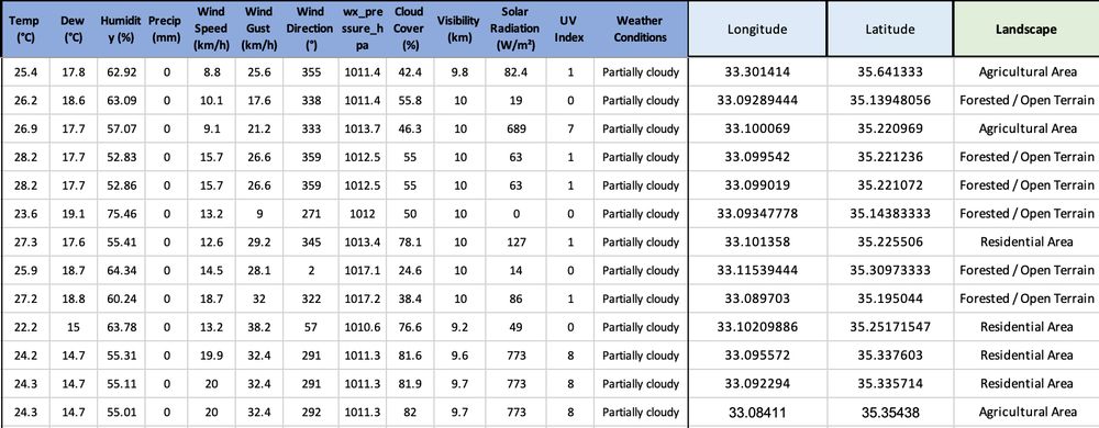
Weather analysis (data from Visual Crossing) reveals a clear operational pattern.
95% of strikes occurred under clear skies, and over 90% during southerly winds from Israel into Lebanon.
Dry conditions and southerly winds maximized plume drift northward and increased fire risk.
95% of strikes occurred under clear skies, and over 90% during southerly winds from Israel into Lebanon.
Dry conditions and southerly winds maximized plume drift northward and increased fire risk.
November 11, 2025 at 3:41 PM
Weather analysis (data from Visual Crossing) reveals a clear operational pattern.
95% of strikes occurred under clear skies, and over 90% during southerly winds from Israel into Lebanon.
Dry conditions and southerly winds maximized plume drift northward and increased fire risk.
95% of strikes occurred under clear skies, and over 90% during southerly winds from Israel into Lebanon.
Dry conditions and southerly winds maximized plume drift northward and increased fire risk.
The IDF says white phosphorus was used for camouflage and smokescreens.
Yet 91% of the strikes occurred before Israel’s ground invasion in October 2024; deep inside Lebanon, far from any troop presence.
Its timing and location suggest a use unrelated to battlefield concealment.
Yet 91% of the strikes occurred before Israel’s ground invasion in October 2024; deep inside Lebanon, far from any troop presence.
Its timing and location suggest a use unrelated to battlefield concealment.
November 11, 2025 at 3:40 PM
The IDF says white phosphorus was used for camouflage and smokescreens.
Yet 91% of the strikes occurred before Israel’s ground invasion in October 2024; deep inside Lebanon, far from any troop presence.
Its timing and location suggest a use unrelated to battlefield concealment.
Yet 91% of the strikes occurred before Israel’s ground invasion in October 2024; deep inside Lebanon, far from any troop presence.
Its timing and location suggest a use unrelated to battlefield concealment.
The IDF claims white phosphorus shells “are not used in densely populated areas, with certain exceptions.”
Yet 39% of strikes hit residential areas and 17% struck agricultural land.
The remaining 44% struck forested or open terrain, possibly intended to clear vegetation.
Yet 39% of strikes hit residential areas and 17% struck agricultural land.
The remaining 44% struck forested or open terrain, possibly intended to clear vegetation.
November 11, 2025 at 3:40 PM
The IDF claims white phosphorus shells “are not used in densely populated areas, with certain exceptions.”
Yet 39% of strikes hit residential areas and 17% struck agricultural land.
The remaining 44% struck forested or open terrain, possibly intended to clear vegetation.
Yet 39% of strikes hit residential areas and 17% struck agricultural land.
The remaining 44% struck forested or open terrain, possibly intended to clear vegetation.
Dive deeper into our research findings featured in an
@aljazeera.com article by @justinsalhani.bsky.social. Our analysis reveals a striking correlation between the geographic distribution of WP and Israel’s latest evacuation maps. www.aljazeera.com/features/202...
@aljazeera.com article by @justinsalhani.bsky.social. Our analysis reveals a striking correlation between the geographic distribution of WP and Israel’s latest evacuation maps. www.aljazeera.com/features/202...

Israel created a buffer zone after using white phosphorus
Israel hit southern Lebanon 191 times with white phosphorus, is that tied to its dreams of a buffer zone?
www.aljazeera.com
December 5, 2024 at 9:18 AM
Dive deeper into our research findings featured in an
@aljazeera.com article by @justinsalhani.bsky.social. Our analysis reveals a striking correlation between the geographic distribution of WP and Israel’s latest evacuation maps. www.aljazeera.com/features/202...
@aljazeera.com article by @justinsalhani.bsky.social. Our analysis reveals a striking correlation between the geographic distribution of WP and Israel’s latest evacuation maps. www.aljazeera.com/features/202...
Join our initiative at whitephosphorus.info. You can assist by geolocating remaining WP footage or sending us your clips for verification. Find the link to our Discord channel on the website and join our investigation to analyze and track white phosphorus use.

White Phosphorus
Mapping, geolocating, and verifying Israel's use of white phosphorus in Lebanon over the past year.
whitephosphorus.info
December 5, 2024 at 9:18 AM
Join our initiative at whitephosphorus.info. You can assist by geolocating remaining WP footage or sending us your clips for verification. Find the link to our Discord channel on the website and join our investigation to analyze and track white phosphorus use.
Explore the patterns and geographic spread of white phosphorus use on our platform. Our interactive maps and geolocations reveal the extent of this incendiary weapon’s impact across #Lebanon. Special thanks to @GreenSoutherners for their on-the-ground efforts and support.
December 5, 2024 at 9:18 AM
Explore the patterns and geographic spread of white phosphorus use on our platform. Our interactive maps and geolocations reveal the extent of this incendiary weapon’s impact across #Lebanon. Special thanks to @GreenSoutherners for their on-the-ground efforts and support.