


WheelieWeather
@wheelieweather.bsky.social
31 year old Disabled weather Nerd, constantly watching the skies for the next exciting thing. Skywarn Storm spotter for @NWSNashville https://weather-ready-nation.printify.me/
After some push from a few folks ive decided to go ahead and set up a little #merch shop. Something I haven’t necessarily looked at doing before but been asked about. Took the leap over the last couple days set it up here’s a few items on there. Feel free to check it out. Link will be in the bio #wx


July 23, 2025 at 10:40 PM
After some push from a few folks ive decided to go ahead and set up a little #merch shop. Something I haven’t necessarily looked at doing before but been asked about. Took the leap over the last couple days set it up here’s a few items on there. Feel free to check it out. Link will be in the bio #wx
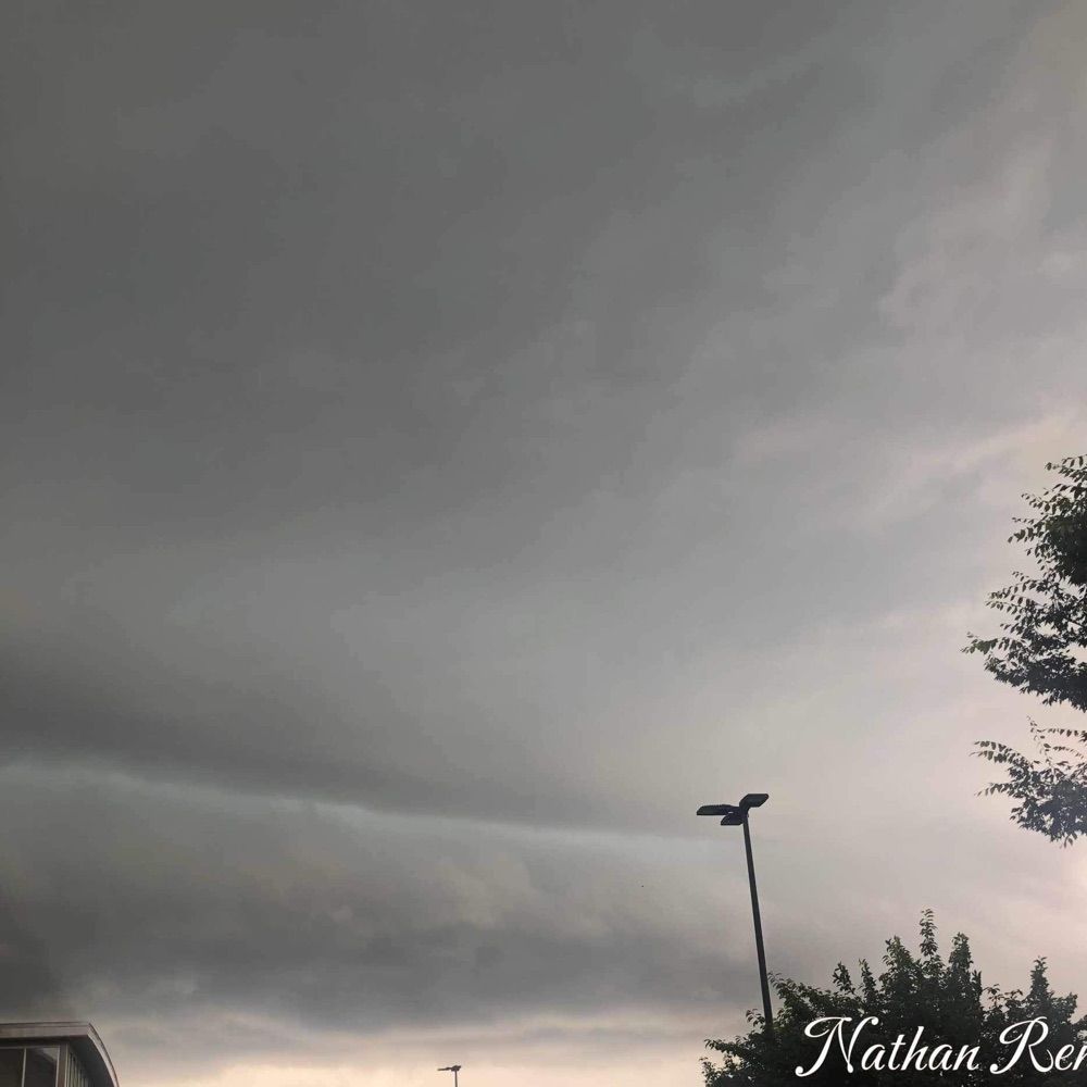
My phone absolutely nerfed these today but, #MiddleTN had a great #Asperitas cloud display this afternoon. #tnsky

March 8, 2025 at 1:36 AM
My phone absolutely nerfed these today but, #MiddleTN had a great #Asperitas cloud display this afternoon. #tnsky
#Snowfall around 2:15pm CST southeast of #Murfreesboro #TN. Have around 3.5” on the ground as of now with a warm nose trying to work into the area and more snow off to the west. See what final totals are later tonight/early tomorrow #tnwx #snow #winterweather #wxsky
January 10, 2025 at 8:55 PM
#Snowfall around 2:15pm CST southeast of #Murfreesboro #TN. Have around 3.5” on the ground as of now with a warm nose trying to work into the area and more snow off to the west. See what final totals are later tonight/early tomorrow #tnwx #snow #winterweather #wxsky
Already over all this snow talk and snow posts. I need a #Thunderstorm a #Mesocyclone in my life bring on #Spring already. #wxsky #Weather #Stormseason #Tornadoseason

December 1, 2024 at 4:17 AM
Already over all this snow talk and snow posts. I need a #Thunderstorm a #Mesocyclone in my life bring on #Spring already. #wxsky #Weather #Stormseason #Tornadoseason
This one was fun 😅. 2016 #KentuckyLake #ParisLanding #Tennessee trying to beat an incoming Severe storm back to the boat ramp during an American Bass anglers tournament. We made it with about 3 minutes to spare before the #lightning rain and wind came though. #tnwx #wxsky

November 27, 2024 at 9:38 PM
This one was fun 😅. 2016 #KentuckyLake #ParisLanding #Tennessee trying to beat an incoming Severe storm back to the boat ramp during an American Bass anglers tournament. We made it with about 3 minutes to spare before the #lightning rain and wind came though. #tnwx #wxsky
One of my favorite #Sunset photos I’ve taken through the years back in 2014 on #Timsfordlake in #Winchester #Tennessee after a long day of Fishing. I’ll never be convinced the water isn’t the best place for these kind’s of photos. #tnwx #wxsky

November 27, 2024 at 9:35 PM
One of my favorite #Sunset photos I’ve taken through the years back in 2014 on #Timsfordlake in #Winchester #Tennessee after a long day of Fishing. I’ll never be convinced the water isn’t the best place for these kind’s of photos. #tnwx #wxsky
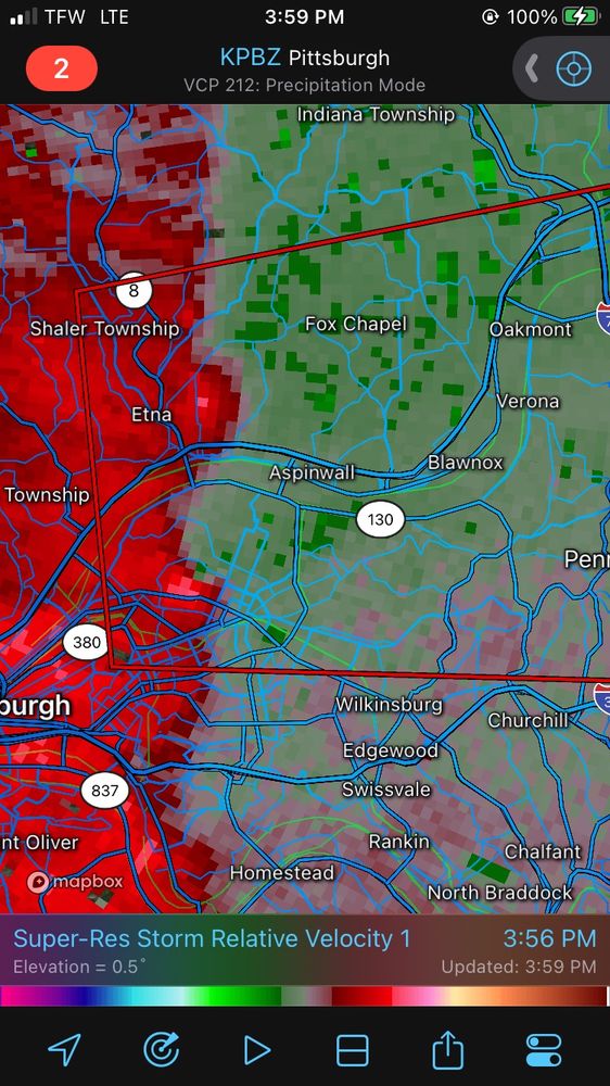
#TornadoWarning for... Allegheny County in Pennsylvania...Westmoreland County in southwestern #Pennsylvania...
Until 530 PM EST
a severe thunderstorm capable of producing a tornado was located over #Aspinwall, or near #pennhillspa, moving east at 40 mph.
Seek shelter if you’re in the path #pawx
Until 530 PM EST
a severe thunderstorm capable of producing a tornado was located over #Aspinwall, or near #pennhillspa, moving east at 40 mph.
Seek shelter if you’re in the path #pawx
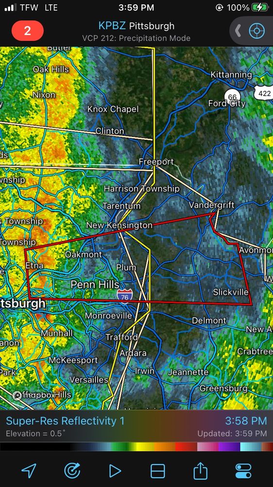
November 20, 2024 at 10:06 PM
#TornadoWarning for... Allegheny County in Pennsylvania...Westmoreland County in southwestern #Pennsylvania...
Until 530 PM EST
a severe thunderstorm capable of producing a tornado was located over #Aspinwall, or near #pennhillspa, moving east at 40 mph.
Seek shelter if you’re in the path #pawx
Until 530 PM EST
a severe thunderstorm capable of producing a tornado was located over #Aspinwall, or near #pennhillspa, moving east at 40 mph.
Seek shelter if you’re in the path #pawx
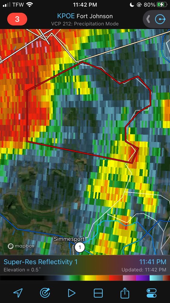
#TornadoWarning for... East central Avoyelles Parish in central #Louisiana...
Until 1215 AM CST.
At 1141 PM CST, a severe thunderstorm capable of producing a tornado was located near #Bordelonville, moving east at 30 mph.
Seek shelter if you’re in the path of this tornado warned storm #lawx
Until 1215 AM CST.
At 1141 PM CST, a severe thunderstorm capable of producing a tornado was located near #Bordelonville, moving east at 30 mph.
Seek shelter if you’re in the path of this tornado warned storm #lawx

November 19, 2024 at 5:45 AM
#TornadoWarning for... East central Avoyelles Parish in central #Louisiana...
Until 1215 AM CST.
At 1141 PM CST, a severe thunderstorm capable of producing a tornado was located near #Bordelonville, moving east at 30 mph.
Seek shelter if you’re in the path of this tornado warned storm #lawx
Until 1215 AM CST.
At 1141 PM CST, a severe thunderstorm capable of producing a tornado was located near #Bordelonville, moving east at 30 mph.
Seek shelter if you’re in the path of this tornado warned storm #lawx
#TornadoWarning for Vernon Parish in west central #Louisiana Newton County in southeastern #Texas...
a severe thunderstorm capable of producing a tornado was located near #ToledoBendDam, moving northeast at 40 mph.
Seek shelter if you’re in the path of this tornado warned storm #lawx #txwx
a severe thunderstorm capable of producing a tornado was located near #ToledoBendDam, moving northeast at 40 mph.
Seek shelter if you’re in the path of this tornado warned storm #lawx #txwx


November 19, 2024 at 12:03 AM
#TornadoWarning for Vernon Parish in west central #Louisiana Newton County in southeastern #Texas...
a severe thunderstorm capable of producing a tornado was located near #ToledoBendDam, moving northeast at 40 mph.
Seek shelter if you’re in the path of this tornado warned storm #lawx #txwx
a severe thunderstorm capable of producing a tornado was located near #ToledoBendDam, moving northeast at 40 mph.
Seek shelter if you’re in the path of this tornado warned storm #lawx #txwx
#Tornadowarning for Northwest Hardin county in southeast #Texas a severe thunderstorm capable of producing a tornado was located near #Thicket, moving northeast at 35 mph.
Seek shelter if you’re in the path of this storm. #txwx #svrwx
Seek shelter if you’re in the path of this storm. #txwx #svrwx


November 18, 2024 at 9:15 PM
#Tornadowarning for Northwest Hardin county in southeast #Texas a severe thunderstorm capable of producing a tornado was located near #Thicket, moving northeast at 35 mph.
Seek shelter if you’re in the path of this storm. #txwx #svrwx
Seek shelter if you’re in the path of this storm. #txwx #svrwx
#Tornadowatch #711 has been issued for parts of #Louisiana and #Texas until 8 PM CST
A couple tornadoes are possible
Isolated hail up to 1/2” in diameter is possible
Scattered damaging wind gusts up to 65MPH are also possible with these storms
#Deridder #Beaumont #Jasper #alexandria #txwx #lawx
A couple tornadoes are possible
Isolated hail up to 1/2” in diameter is possible
Scattered damaging wind gusts up to 65MPH are also possible with these storms
#Deridder #Beaumont #Jasper #alexandria #txwx #lawx

November 18, 2024 at 9:08 PM
#Tornadowatch #711 has been issued for parts of #Louisiana and #Texas until 8 PM CST
A couple tornadoes are possible
Isolated hail up to 1/2” in diameter is possible
Scattered damaging wind gusts up to 65MPH are also possible with these storms
#Deridder #Beaumont #Jasper #alexandria #txwx #lawx
A couple tornadoes are possible
Isolated hail up to 1/2” in diameter is possible
Scattered damaging wind gusts up to 65MPH are also possible with these storms
#Deridder #Beaumont #Jasper #alexandria #txwx #lawx
01/01/2022 on the way back from a shopping trip that saw a friend and I drive into two #Tornado warned storms that afternoon in #Nashville #Tennessee. This photo is my favorite of the day from #Murfressboro. The lone tornado occurred early in the morning in #Martin Tennessee that day. #tnwx

November 15, 2024 at 3:17 AM
01/01/2022 on the way back from a shopping trip that saw a friend and I drive into two #Tornado warned storms that afternoon in #Nashville #Tennessee. This photo is my favorite of the day from #Murfressboro. The lone tornado occurred early in the morning in #Martin Tennessee that day. #tnwx
1:00 CST Radar update across #MiddleTennessee & Southern #Kentucky beneficial rain moving northeast as the cold front approaches. Not a drought buster but it helps. #tnwx #kywx #wxbluesky

November 14, 2024 at 7:02 AM
1:00 CST Radar update across #MiddleTennessee & Southern #Kentucky beneficial rain moving northeast as the cold front approaches. Not a drought buster but it helps. #tnwx #kywx #wxbluesky
May 2nd 2024 Shelf cloud from a storm over #Murfeesboro #Tennessee. Wasn’t in the best position. Still happy with some sort of structure this year. #tnwx #blueskywx

November 13, 2024 at 4:38 AM
May 2nd 2024 Shelf cloud from a storm over #Murfeesboro #Tennessee. Wasn’t in the best position. Still happy with some sort of structure this year. #tnwx #blueskywx