


Northern Tornadoes Project 🇨🇦
@westernuntp.bsky.social
Founded in 2017 at Western University with support from ImpactWX.com, NTP aims to detect and document all tornadoes in Canada and uncover Canada’s true tornado climatology. Now part of the Canadian Severe Storms Lab! See uwo.ca/ntp & cssl.ca.
Dive into real-world research and fieldwork with the CSSL Summer Internship Program!
Learn more and apply here: uwo.ca/cssl/interns...
Don't miss your chance to gain hands-on experience with leading tornado and hail experts in the field.
Applications close on January 26th.
Learn more and apply here: uwo.ca/cssl/interns...
Don't miss your chance to gain hands-on experience with leading tornado and hail experts in the field.
Applications close on January 26th.

December 1, 2025 at 3:56 PM
Dive into real-world research and fieldwork with the CSSL Summer Internship Program!
Learn more and apply here: uwo.ca/cssl/interns...
Don't miss your chance to gain hands-on experience with leading tornado and hail experts in the field.
Applications close on January 26th.
Learn more and apply here: uwo.ca/cssl/interns...
Don't miss your chance to gain hands-on experience with leading tornado and hail experts in the field.
Applications close on January 26th.
The NTP has confirmed 6 more Prairie tornadoes with ratings EF2 to EF0-Default. Four are based on AI-assisted satellite review of forest areas in AB / SK while two (plus an update of an existing tornado) in AB are based on reports from Riley Weekes. Details: uwo.ca/ntp/blog/202... #ABstorm #SKstorm

November 24, 2025 at 6:13 PM
The NTP has confirmed 6 more Prairie tornadoes with ratings EF2 to EF0-Default. Four are based on AI-assisted satellite review of forest areas in AB / SK while two (plus an update of an existing tornado) in AB are based on reports from Riley Weekes. Details: uwo.ca/ntp/blog/202... #ABstorm #SKstorm
Looks like only 10 tornadoes made it to the map somehow. Here is the same regional map showing all 11 tornadoes.
November 12, 2025 at 4:53 PM
Looks like only 10 tornadoes made it to the map somehow. Here is the same regional map showing all 11 tornadoes.
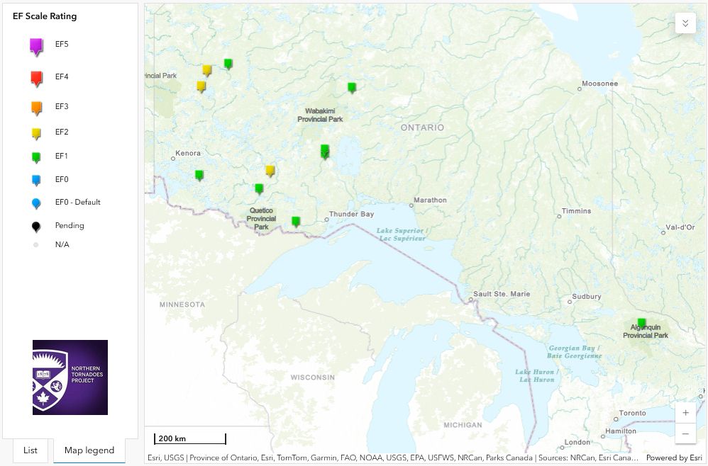
The NTP has confirmed 11 new ON tornadoes based on AI-assisted satellite review. All caused EF1-EF2 tree damage.
These are in addition to 5 tornadoes already confirmed in ON via AI-assisted satellite review. All sectors in Ontario have now been reviewed.
Details: uwo.ca/ntp/blog/202...
#ONstorm
These are in addition to 5 tornadoes already confirmed in ON via AI-assisted satellite review. All sectors in Ontario have now been reviewed.
Details: uwo.ca/ntp/blog/202...
#ONstorm

November 12, 2025 at 3:46 PM
The NTP has confirmed 11 new ON tornadoes based on AI-assisted satellite review. All caused EF1-EF2 tree damage.
These are in addition to 5 tornadoes already confirmed in ON via AI-assisted satellite review. All sectors in Ontario have now been reviewed.
Details: uwo.ca/ntp/blog/202...
#ONstorm
These are in addition to 5 tornadoes already confirmed in ON via AI-assisted satellite review. All sectors in Ontario have now been reviewed.
Details: uwo.ca/ntp/blog/202...
#ONstorm
The NTP has confirmed nine new Quebec tornadoes for 2025 based on our end-of-season satellite review, assisted by an AI detection algorithm. The damage in each case was only to trees, with one tornado rated EF2 and eight rated EF1.
Details: uwo.ca/ntp/blog/202...
#meteoQC
Details: uwo.ca/ntp/blog/202...
#meteoQC

October 27, 2025 at 3:33 PM
The NTP has confirmed nine new Quebec tornadoes for 2025 based on our end-of-season satellite review, assisted by an AI detection algorithm. The damage in each case was only to trees, with one tornado rated EF2 and eight rated EF1.
Details: uwo.ca/ntp/blog/202...
#meteoQC
Details: uwo.ca/ntp/blog/202...
#meteoQC
The NTP has confirmed a tornado over water (waterspout) that was reported off the coast of Nova Scotia near Rocky Bay on October 25.
Details at uwo.ca/ntp/blog/202....
#NSstorm
Details at uwo.ca/ntp/blog/202....
#NSstorm

October 27, 2025 at 2:48 PM
The NTP has confirmed a tornado over water (waterspout) that was reported off the coast of Nova Scotia near Rocky Bay on October 25.
Details at uwo.ca/ntp/blog/202....
#NSstorm
Details at uwo.ca/ntp/blog/202....
#NSstorm
The NTP has confirmed a new tornado over water (waterspout) that occurred over Lake Huron northwest of Bayfield, ON yesterday.
Details at the NTP blog here:
uwo.ca/ntp/blog/202...
#ONstorm
Details at the NTP blog here:
uwo.ca/ntp/blog/202...
#ONstorm

October 25, 2025 at 4:59 PM
The NTP has confirmed a new tornado over water (waterspout) that occurred over Lake Huron northwest of Bayfield, ON yesterday.
Details at the NTP blog here:
uwo.ca/ntp/blog/202...
#ONstorm
Details at the NTP blog here:
uwo.ca/ntp/blog/202...
#ONstorm
The NTP has confirmed five concurrent tornadoes over water (waterspouts) over Lake Erie off Long Point on Oct 21.
Details at the NTP blog here: uwo.ca/ntp/blog/202...
#ONstorm
Details at the NTP blog here: uwo.ca/ntp/blog/202...
#ONstorm

October 23, 2025 at 4:30 PM
The NTP has confirmed five concurrent tornadoes over water (waterspouts) over Lake Erie off Long Point on Oct 21.
Details at the NTP blog here: uwo.ca/ntp/blog/202...
#ONstorm
Details at the NTP blog here: uwo.ca/ntp/blog/202...
#ONstorm
The CSSL/NTP assisted the US National Weather Service (NWS) with their upgrading of the official rating of the June 2025 Enderlin, ND tornado from EF3 to EF5.
Announced by the NWS today, it’s the first EF5-rated tornado in the US since 2013.
Details here: uwo.ca/ntp/blog/202...
Image B. Emfinger
Announced by the NWS today, it’s the first EF5-rated tornado in the US since 2013.
Details here: uwo.ca/ntp/blog/202...
Image B. Emfinger

October 6, 2025 at 6:16 PM
The CSSL/NTP assisted the US National Weather Service (NWS) with their upgrading of the official rating of the June 2025 Enderlin, ND tornado from EF3 to EF5.
Announced by the NWS today, it’s the first EF5-rated tornado in the US since 2013.
Details here: uwo.ca/ntp/blog/202...
Image B. Emfinger
Announced by the NWS today, it’s the first EF5-rated tornado in the US since 2013.
Details here: uwo.ca/ntp/blog/202...
Image B. Emfinger
The first forested area to be searched with NTP's new AI tool - Northern Ontario east of Lake Superior - turned up five tornadoes, including one rated EF2. These were all manually verified and documented.
Details here:
uwo.ca/ntp/blog/202...
#ONstorm
Lots more to come...
Details here:
uwo.ca/ntp/blog/202...
#ONstorm
Lots more to come...

October 3, 2025 at 4:19 PM
The first forested area to be searched with NTP's new AI tool - Northern Ontario east of Lake Superior - turned up five tornadoes, including one rated EF2. These were all manually verified and documented.
Details here:
uwo.ca/ntp/blog/202...
#ONstorm
Lots more to come...
Details here:
uwo.ca/ntp/blog/202...
#ONstorm
Lots more to come...
Today we have a special blog post on a new NTP tool for AI-assisted satellite review, with the method described by its developer - the NTP's Daniel Butt. The tool is being used experimentally and is already producing results. More on that shortly!
uwo.ca/ntp/blog/202...
uwo.ca/ntp/blog/202...

October 3, 2025 at 3:00 PM
Today we have a special blog post on a new NTP tool for AI-assisted satellite review, with the method described by its developer - the NTP's Daniel Butt. The tool is being used experimentally and is already producing results. More on that shortly!
uwo.ca/ntp/blog/202...
uwo.ca/ntp/blog/202...
Following a thorough satellite review for storm tracks of interest, the NTP has confirmed three new EF1 tornadoes from earlier in the season in Quebec.
The first two occurred on April 29 and the third on June 23.
Details at:
uwo.ca/ntp/blog/202...
#meteoQC
The first two occurred on April 29 and the third on June 23.
Details at:
uwo.ca/ntp/blog/202...
#meteoQC

October 2, 2025 at 3:39 PM
Following a thorough satellite review for storm tracks of interest, the NTP has confirmed three new EF1 tornadoes from earlier in the season in Quebec.
The first two occurred on April 29 and the third on June 23.
Details at:
uwo.ca/ntp/blog/202...
#meteoQC
The first two occurred on April 29 and the third on June 23.
Details at:
uwo.ca/ntp/blog/202...
#meteoQC
The NTP has confirmed three new tornadoes and upgraded a downburst damage rating in Northern Ontario.
Details here:
uwo.ca/ntp/blog/202...
#ONstorm
Details here:
uwo.ca/ntp/blog/202...
#ONstorm

October 2, 2025 at 1:05 PM
The NTP has confirmed three new tornadoes and upgraded a downburst damage rating in Northern Ontario.
Details here:
uwo.ca/ntp/blog/202...
#ONstorm
Details here:
uwo.ca/ntp/blog/202...
#ONstorm
The NTP has confirmed four EF2 tornadoes in western Quebec during the late afternoon and evening hours of September 5. In each case there was considerable tree damage.
Full details can be found here:
uwo.ca/ntp/blog/202...
#meteoQC
Full details can be found here:
uwo.ca/ntp/blog/202...
#meteoQC

September 30, 2025 at 7:18 PM
The NTP has confirmed four EF2 tornadoes in western Quebec during the late afternoon and evening hours of September 5. In each case there was considerable tree damage.
Full details can be found here:
uwo.ca/ntp/blog/202...
#meteoQC
Full details can be found here:
uwo.ca/ntp/blog/202...
#meteoQC
An additional 4 tornadoes have been confirmed by NTP for Quebec from June based on satellite imagery review. There was 1 EF2 tornado and 3 EF1 tornadoes.
Details at the NTP blog here: uwo.ca/ntp/blog/202.... Tornadoes are plotted on a regional map below.
#meteoQC #QCstorm
Details at the NTP blog here: uwo.ca/ntp/blog/202.... Tornadoes are plotted on a regional map below.
#meteoQC #QCstorm

September 8, 2025 at 5:07 PM
An additional 4 tornadoes have been confirmed by NTP for Quebec from June based on satellite imagery review. There was 1 EF2 tornado and 3 EF1 tornadoes.
Details at the NTP blog here: uwo.ca/ntp/blog/202.... Tornadoes are plotted on a regional map below.
#meteoQC #QCstorm
Details at the NTP blog here: uwo.ca/ntp/blog/202.... Tornadoes are plotted on a regional map below.
#meteoQC #QCstorm
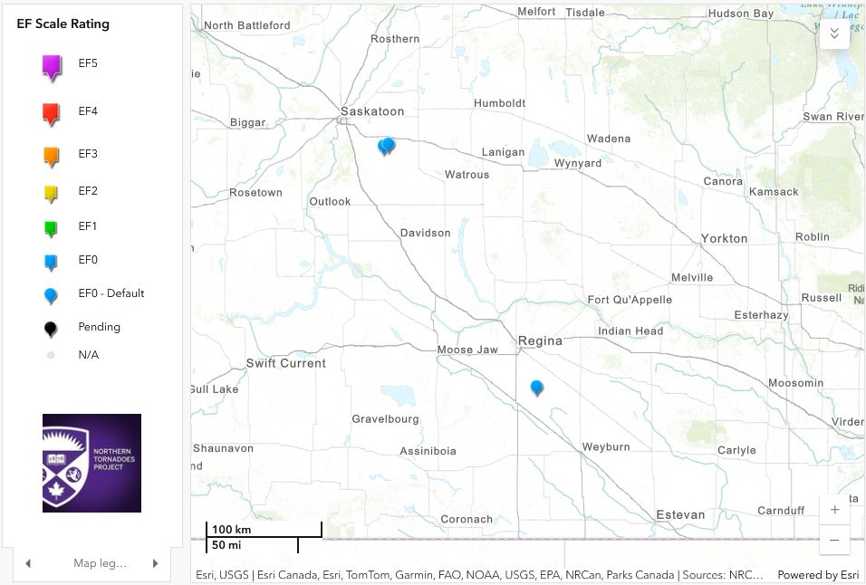
The NTP has confirmed an additional 6 tornadoes for the Prairie provinces based on witness reports - 2 in AB, 3 in SK and 1 in MB. An EF0-Default rating is assigned for each since no damage was reported or detected.
See the NTP blog for details: uwo.ca/ntp/blog/202...
#ABstorm #SKstorm #MBstorm
See the NTP blog for details: uwo.ca/ntp/blog/202...
#ABstorm #SKstorm #MBstorm


September 8, 2025 at 5:03 PM
The NTP has confirmed an additional 6 tornadoes for the Prairie provinces based on witness reports - 2 in AB, 3 in SK and 1 in MB. An EF0-Default rating is assigned for each since no damage was reported or detected.
See the NTP blog for details: uwo.ca/ntp/blog/202...
#ABstorm #SKstorm #MBstorm
See the NTP blog for details: uwo.ca/ntp/blog/202...
#ABstorm #SKstorm #MBstorm
The NTP has confirmed three tornadoes over Lake Erie from the evening of August 28.
See here for details: uwo.ca/ntp/blog/202...
#ONstorm
See here for details: uwo.ca/ntp/blog/202...
#ONstorm

September 2, 2025 at 4:37 PM
The NTP has confirmed three tornadoes over Lake Erie from the evening of August 28.
See here for details: uwo.ca/ntp/blog/202...
#ONstorm
See here for details: uwo.ca/ntp/blog/202...
#ONstorm
The NTP has confirmed three new tornadoes in southern AB from June, all rated EF0-Default.
Details at uwo.ca/ntp/blog/202....
#ABstorm
Details at uwo.ca/ntp/blog/202....
#ABstorm

August 30, 2025 at 2:41 PM
The NTP has confirmed three new tornadoes in southern AB from June, all rated EF0-Default.
Details at uwo.ca/ntp/blog/202....
#ABstorm
Details at uwo.ca/ntp/blog/202....
#ABstorm
The NTP has confirmed that a downburst (paired with large hail) caused high-end EF1 damage in the Brooks, AB area on August 20.
Details at the NTP blog here: uwo.ca/ntp/blog/202...
Note that ongoing analysis may result in additional events and/or a rating upgrade.
#ABstorm #SKstorm
Details at the NTP blog here: uwo.ca/ntp/blog/202...
Note that ongoing analysis may result in additional events and/or a rating upgrade.
#ABstorm #SKstorm

August 28, 2025 at 4:14 PM
The NTP has confirmed that a downburst (paired with large hail) caused high-end EF1 damage in the Brooks, AB area on August 20.
Details at the NTP blog here: uwo.ca/ntp/blog/202...
Note that ongoing analysis may result in additional events and/or a rating upgrade.
#ABstorm #SKstorm
Details at the NTP blog here: uwo.ca/ntp/blog/202...
Note that ongoing analysis may result in additional events and/or a rating upgrade.
#ABstorm #SKstorm
The NTP has confirmed two EF1 downbursts (one being a microburst), an EF0 tornado and a gustnado from the SK storms of Aug 20 near Saskatoon.
The assessments are based on witness reports, an NTP damage survey, and radar/satellite imagery analysis.
Details here: uwo.ca/ntp/blog/202...
#SKstorm
The assessments are based on witness reports, an NTP damage survey, and radar/satellite imagery analysis.
Details here: uwo.ca/ntp/blog/202...
#SKstorm

August 28, 2025 at 4:07 PM
The NTP has confirmed two EF1 downbursts (one being a microburst), an EF0 tornado and a gustnado from the SK storms of Aug 20 near Saskatoon.
The assessments are based on witness reports, an NTP damage survey, and radar/satellite imagery analysis.
Details here: uwo.ca/ntp/blog/202...
#SKstorm
The assessments are based on witness reports, an NTP damage survey, and radar/satellite imagery analysis.
Details here: uwo.ca/ntp/blog/202...
#SKstorm
The NTP has confirmed four additional tornadoes over water (waterspouts) that occurred in the Canadian waters of the Great Lakes in August.
See the following for details:
uwo.ca/ntp/blog/202...
#ONstorm
See the following for details:
uwo.ca/ntp/blog/202...
#ONstorm

August 26, 2025 at 2:59 AM
The NTP has confirmed four additional tornadoes over water (waterspouts) that occurred in the Canadian waters of the Great Lakes in August.
See the following for details:
uwo.ca/ntp/blog/202...
#ONstorm
See the following for details:
uwo.ca/ntp/blog/202...
#ONstorm
The NTP has confirmed three EF2 tornadoes that occurred in NE Ontario near Englehart on July 12.
Satellite imagery was used to identify the tracks of significant tree damage.
Details at uwo.ca/ntp/blog/202...
#ONstorm
Satellite imagery was used to identify the tracks of significant tree damage.
Details at uwo.ca/ntp/blog/202...
#ONstorm

August 26, 2025 at 12:57 AM
The NTP has confirmed three EF2 tornadoes that occurred in NE Ontario near Englehart on July 12.
Satellite imagery was used to identify the tracks of significant tree damage.
Details at uwo.ca/ntp/blog/202...
#ONstorm
Satellite imagery was used to identify the tracks of significant tree damage.
Details at uwo.ca/ntp/blog/202...
#ONstorm
There are numerous reports of significant wind damage in southeastern Alberta from intense storms earlier today. Hail damage has also been reported.
An NTP survey team will leave tomorrow for the area to thoroughly assess the damage.
Please send damage reports to @ntp-reports.bsky.social. #ABstorm
An NTP survey team will leave tomorrow for the area to thoroughly assess the damage.
Please send damage reports to @ntp-reports.bsky.social. #ABstorm
August 21, 2025 at 3:56 AM
There are numerous reports of significant wind damage in southeastern Alberta from intense storms earlier today. Hail damage has also been reported.
An NTP survey team will leave tomorrow for the area to thoroughly assess the damage.
Please send damage reports to @ntp-reports.bsky.social. #ABstorm
An NTP survey team will leave tomorrow for the area to thoroughly assess the damage.
Please send damage reports to @ntp-reports.bsky.social. #ABstorm
Following a damage survey in the Wheatley, ON area, NTP has confirmed that a microburst caused EF0 damage early on August 17.
The max wind speed is estimated to be 130 km/h but the damage was very localized.
Details can be found at the NTP blog here: uwo.ca/ntp/blog/202...
#ONstorm
The max wind speed is estimated to be 130 km/h but the damage was very localized.
Details can be found at the NTP blog here: uwo.ca/ntp/blog/202...
#ONstorm

August 20, 2025 at 4:12 PM
Following a damage survey in the Wheatley, ON area, NTP has confirmed that a microburst caused EF0 damage early on August 17.
The max wind speed is estimated to be 130 km/h but the damage was very localized.
Details can be found at the NTP blog here: uwo.ca/ntp/blog/202...
#ONstorm
The max wind speed is estimated to be 130 km/h but the damage was very localized.
Details can be found at the NTP blog here: uwo.ca/ntp/blog/202...
#ONstorm
Today’s early morning storms in SW Ontario caused isolated wind damage in the Wheatley area. A large drive shed had its roof removed.
An NTP survey team will leave for that area Monday morning to investigate.
When results are available, you'll see a link to them here. #ONstorm
An NTP survey team will leave for that area Monday morning to investigate.
When results are available, you'll see a link to them here. #ONstorm
August 18, 2025 at 2:11 AM
Today’s early morning storms in SW Ontario caused isolated wind damage in the Wheatley area. A large drive shed had its roof removed.
An NTP survey team will leave for that area Monday morning to investigate.
When results are available, you'll see a link to them here. #ONstorm
An NTP survey team will leave for that area Monday morning to investigate.
When results are available, you'll see a link to them here. #ONstorm