


@webberweather.bsky.social
Gov't meteorologist. UNCC & NCSU Alum. Specializes in Climate Dynamics & S2S variability. Opinions are my own & not a reflection of my employer.
webberweather.com
webberweather.com
The ongoing MJO event in the West Pacific has led to a *gigantic* build-up of westerly momentum in the tropical troposphere, w/ GLAAM anomalies approaching 3 sigma! Very El Nino-like

November 29, 2025 at 10:31 PM
The ongoing MJO event in the West Pacific has led to a *gigantic* build-up of westerly momentum in the tropical troposphere, w/ GLAAM anomalies approaching 3 sigma! Very El Nino-like
TAO buoy subsurface animation for this past month
Notice the thermocline is quickly deepening and the subsurface anomalies are beginning to advance eastward over the West-Central Equatorial Pacific.
Notice the thermocline is quickly deepening and the subsurface anomalies are beginning to advance eastward over the West-Central Equatorial Pacific.
November 29, 2025 at 7:43 PM
TAO buoy subsurface animation for this past month
Notice the thermocline is quickly deepening and the subsurface anomalies are beginning to advance eastward over the West-Central Equatorial Pacific.
Notice the thermocline is quickly deepening and the subsurface anomalies are beginning to advance eastward over the West-Central Equatorial Pacific.
The thermocline in the West-Central Eq. Pacific is already responding to the Westerly Wind Burst event & -IOD collapse that occurred earlier this month in association w/ the MJO.
A downwelling Kelvin Wave is forming over the West Pacific & will help eventually destroy La Nina in a few months or so.
A downwelling Kelvin Wave is forming over the West Pacific & will help eventually destroy La Nina in a few months or so.


November 29, 2025 at 2:43 AM
The thermocline in the West-Central Eq. Pacific is already responding to the Westerly Wind Burst event & -IOD collapse that occurred earlier this month in association w/ the MJO.
A downwelling Kelvin Wave is forming over the West Pacific & will help eventually destroy La Nina in a few months or so.
A downwelling Kelvin Wave is forming over the West Pacific & will help eventually destroy La Nina in a few months or so.
The GEFS and Euro AIFS ensembles trying to give me some hope for snow in early December.
Surely, this must be a trap.
Surely, this must be a trap.


November 23, 2025 at 8:25 PM
The GEFS and Euro AIFS ensembles trying to give me some hope for snow in early December.
Surely, this must be a trap.
Surely, this must be a trap.
The low-level westerly wind burst in the pacific is what’s really driving the MJO into the Western Hemisphere (phase 8) in Dec (left)
That to me is a very telling of how hard the atmosphere is pushing the ocean away from La Niña & possibly towards an El Niño state this coming spring or summer
That to me is a very telling of how hard the atmosphere is pushing the ocean away from La Niña & possibly towards an El Niño state this coming spring or summer


November 21, 2025 at 2:27 PM
The low-level westerly wind burst in the pacific is what’s really driving the MJO into the Western Hemisphere (phase 8) in Dec (left)
That to me is a very telling of how hard the atmosphere is pushing the ocean away from La Niña & possibly towards an El Niño state this coming spring or summer
That to me is a very telling of how hard the atmosphere is pushing the ocean away from La Niña & possibly towards an El Niño state this coming spring or summer
The warmest water on the entire planet is sitting ~160E in the Equatorial Pacific & a prolonged Westerly Wind Burst event is about to occur here
This will trigger a downwelling oceanic kelvin wave that should destroy La Niña ~3 months from now & begin moving the ocean towards El Niño conditions
This will trigger a downwelling oceanic kelvin wave that should destroy La Niña ~3 months from now & begin moving the ocean towards El Niño conditions

November 19, 2025 at 12:59 PM
The warmest water on the entire planet is sitting ~160E in the Equatorial Pacific & a prolonged Westerly Wind Burst event is about to occur here
This will trigger a downwelling oceanic kelvin wave that should destroy La Niña ~3 months from now & begin moving the ocean towards El Niño conditions
This will trigger a downwelling oceanic kelvin wave that should destroy La Niña ~3 months from now & begin moving the ocean towards El Niño conditions
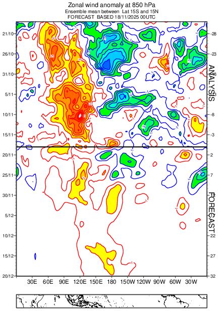
We might be in a La Niña at the moment, but the tropical troposphere already looks very El Niño-like with a huge build-up of deep-layer westerly wind anomalies
In the grand scheme of things, El Nino is likely knocking on the door 🚪
In the grand scheme of things, El Nino is likely knocking on the door 🚪


November 18, 2025 at 11:34 PM
We might be in a La Niña at the moment, but the tropical troposphere already looks very El Niño-like with a huge build-up of deep-layer westerly wind anomalies
In the grand scheme of things, El Nino is likely knocking on the door 🚪
In the grand scheme of things, El Nino is likely knocking on the door 🚪
For all my S2S junkies out there, here’s another invaluable tool to add to your arsenal:
An annual archive of polar cap geopotential height anomalies going back to 1940 using ERA-5 & a 30-year sliding climatology
👀
hebweather.net/prod/gph_arc...
An annual archive of polar cap geopotential height anomalies going back to 1940 using ERA-5 & a 30-year sliding climatology
👀
hebweather.net/prod/gph_arc...

November 18, 2025 at 11:03 PM
For all my S2S junkies out there, here’s another invaluable tool to add to your arsenal:
An annual archive of polar cap geopotential height anomalies going back to 1940 using ERA-5 & a 30-year sliding climatology
👀
hebweather.net/prod/gph_arc...
An annual archive of polar cap geopotential height anomalies going back to 1940 using ERA-5 & a 30-year sliding climatology
👀
hebweather.net/prod/gph_arc...
Cool study came out earlier this yr looking at the dynamical origins of the extreme 2023 Heatwave in the Desert SW
They concluded that the warm Tropical Atlantic was the primary culprit
The partial regression analysis (left) & AGCM forcing (right) are pretty telling
www.nature.com/articles/s41...
They concluded that the warm Tropical Atlantic was the primary culprit
The partial regression analysis (left) & AGCM forcing (right) are pretty telling
www.nature.com/articles/s41...


November 17, 2025 at 4:57 PM
Cool study came out earlier this yr looking at the dynamical origins of the extreme 2023 Heatwave in the Desert SW
They concluded that the warm Tropical Atlantic was the primary culprit
The partial regression analysis (left) & AGCM forcing (right) are pretty telling
www.nature.com/articles/s41...
They concluded that the warm Tropical Atlantic was the primary culprit
The partial regression analysis (left) & AGCM forcing (right) are pretty telling
www.nature.com/articles/s41...
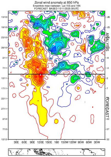
I still can’t get over how similar this year’s zonal wind anomalies in the tropics are to 1981


November 16, 2025 at 6:45 PM
I still can’t get over how similar this year’s zonal wind anomalies in the tropics are to 1981
This increase in tropical westerly momentum favors an equatorward shift in the Pacific Jet Stream, which leads to an increase chance of high-latitude North Pacific blocking (-EPO), consistent with current model forecasts & Winters et al (2019)
journals.ametsoc.org/view/journal...
journals.ametsoc.org/view/journal...


November 11, 2025 at 11:02 PM
This increase in tropical westerly momentum favors an equatorward shift in the Pacific Jet Stream, which leads to an increase chance of high-latitude North Pacific blocking (-EPO), consistent with current model forecasts & Winters et al (2019)
journals.ametsoc.org/view/journal...
journals.ametsoc.org/view/journal...
Quietly while La Niña persists, the tropical upper troposphere is becoming very El Niño-like
A large build-up of westerly momentum (+U) in the tropics is being supplanted by a West Pac MJO orbit & repeated bouts of positive E Asia Mtn Torque (+EAMT) fluxing/squeezing +U equatorward
A large build-up of westerly momentum (+U) in the tropics is being supplanted by a West Pac MJO orbit & repeated bouts of positive E Asia Mtn Torque (+EAMT) fluxing/squeezing +U equatorward


November 11, 2025 at 11:01 PM
Quietly while La Niña persists, the tropical upper troposphere is becoming very El Niño-like
A large build-up of westerly momentum (+U) in the tropics is being supplanted by a West Pac MJO orbit & repeated bouts of positive E Asia Mtn Torque (+EAMT) fluxing/squeezing +U equatorward
A large build-up of westerly momentum (+U) in the tropics is being supplanted by a West Pac MJO orbit & repeated bouts of positive E Asia Mtn Torque (+EAMT) fluxing/squeezing +U equatorward
The global tropics zonal wind anomalies this year are evolving very similarly to late 1981, which of course preceded a “Super” El Niño event in 1982
Note how this yr & 1981 have a big & slow westerly wind burst over the Indian Ocean & Maritime Continent in Oct-Nov that moved into the Pacific in Dec
Note how this yr & 1981 have a big & slow westerly wind burst over the Indian Ocean & Maritime Continent in Oct-Nov that moved into the Pacific in Dec

November 11, 2025 at 10:07 PM
The global tropics zonal wind anomalies this year are evolving very similarly to late 1981, which of course preceded a “Super” El Niño event in 1982
Note how this yr & 1981 have a big & slow westerly wind burst over the Indian Ocean & Maritime Continent in Oct-Nov that moved into the Pacific in Dec
Note how this yr & 1981 have a big & slow westerly wind burst over the Indian Ocean & Maritime Continent in Oct-Nov that moved into the Pacific in Dec
As you might expect from the very strong -IOD event strengthening La Nina’s footprint globally, this October’s observed pattern has deviated very little from the last 30 years worth of La Ninas over N America


November 7, 2025 at 10:55 PM
As you might expect from the very strong -IOD event strengthening La Nina’s footprint globally, this October’s observed pattern has deviated very little from the last 30 years worth of La Ninas over N America
Even when you look at November, this year really isn’t doing anything out of the ordinary for a La Niña


November 7, 2025 at 2:16 PM
Even when you look at November, this year really isn’t doing anything out of the ordinary for a La Niña
The latest Euro weekly forecast thru mid-December is almost exactly what you’d expect for typical a La Niña December over the last 30 years:
A faster-than-usual start to winter over the East-Central US with plenty of high-latitude blocking
A faster-than-usual start to winter over the East-Central US with plenty of high-latitude blocking


November 7, 2025 at 1:53 PM
The latest Euro weekly forecast thru mid-December is almost exactly what you’d expect for typical a La Niña December over the last 30 years:
A faster-than-usual start to winter over the East-Central US with plenty of high-latitude blocking
A faster-than-usual start to winter over the East-Central US with plenty of high-latitude blocking
thanks ant 😃!
I found the east qbo/solar max tendency for strong late winter/early spring +NAM to be weird at first, but It‘s indeed very real.
agupubs.onlinelibrary.wiley.com/doi/full/10....
I found the east qbo/solar max tendency for strong late winter/early spring +NAM to be weird at first, but It‘s indeed very real.
agupubs.onlinelibrary.wiley.com/doi/full/10....


November 6, 2025 at 12:26 PM
thanks ant 😃!
I found the east qbo/solar max tendency for strong late winter/early spring +NAM to be weird at first, but It‘s indeed very real.
agupubs.onlinelibrary.wiley.com/doi/full/10....
I found the east qbo/solar max tendency for strong late winter/early spring +NAM to be weird at first, but It‘s indeed very real.
agupubs.onlinelibrary.wiley.com/doi/full/10....
La Niña is living on borrowed time.
The extreme -IOD we're currently seeing (right) is about to collapse because the warm water in the Equatorial Indian Ocean will get flushed into the tropical West Pac at depth over the next month in this MJO event's westerly wind burst (left)
The extreme -IOD we're currently seeing (right) is about to collapse because the warm water in the Equatorial Indian Ocean will get flushed into the tropical West Pac at depth over the next month in this MJO event's westerly wind burst (left)


November 5, 2025 at 9:10 PM
La Niña is living on borrowed time.
The extreme -IOD we're currently seeing (right) is about to collapse because the warm water in the Equatorial Indian Ocean will get flushed into the tropical West Pac at depth over the next month in this MJO event's westerly wind burst (left)
The extreme -IOD we're currently seeing (right) is about to collapse because the warm water in the Equatorial Indian Ocean will get flushed into the tropical West Pac at depth over the next month in this MJO event's westerly wind burst (left)
Also, the current global tropics SSTa are also almost the exact opposite of the MJO phase speed & SST correlation pattern derived from Suematsu & Miura (2021): journals.ametsoc.org/view/journal...


November 3, 2025 at 10:17 PM
Also, the current global tropics SSTa are also almost the exact opposite of the MJO phase speed & SST correlation pattern derived from Suematsu & Miura (2021): journals.ametsoc.org/view/journal...
Many things are lining up for a fast start to winter this year in the East-Central US
For ex: being in a La Niña w/ a slower-moving and more amplified MJO (due in part to easterly QBO) makes a subsequent -NAO/AO more likely
Fig from Lee et al (2019): agupubs.onlinelibrary.wiley.com/doi/full/10....
For ex: being in a La Niña w/ a slower-moving and more amplified MJO (due in part to easterly QBO) makes a subsequent -NAO/AO more likely
Fig from Lee et al (2019): agupubs.onlinelibrary.wiley.com/doi/full/10....

November 3, 2025 at 10:16 PM
Many things are lining up for a fast start to winter this year in the East-Central US
For ex: being in a La Niña w/ a slower-moving and more amplified MJO (due in part to easterly QBO) makes a subsequent -NAO/AO more likely
Fig from Lee et al (2019): agupubs.onlinelibrary.wiley.com/doi/full/10....
For ex: being in a La Niña w/ a slower-moving and more amplified MJO (due in part to easterly QBO) makes a subsequent -NAO/AO more likely
Fig from Lee et al (2019): agupubs.onlinelibrary.wiley.com/doi/full/10....
The other key takeaway here about these kinds of winters is that we see more frequent early winter -AO/-NAO & stratospheric warming events (as the latest Euro weeklies below suggest), followed by a much stronger polar vortex in mid-late winter (Jan-Feb)

November 3, 2025 at 10:05 PM
The other key takeaway here about these kinds of winters is that we see more frequent early winter -AO/-NAO & stratospheric warming events (as the latest Euro weeklies below suggest), followed by a much stronger polar vortex in mid-late winter (Jan-Feb)
This winter seems to be intent on following the cool ENSO/East QBO/solar max paradigm of early winter -AO/-NAO
I replicated Gray et al (2004)'s analysis except used SLPa from 20CR & isolated -ENSO (left), which is close to the latest Euro weekly forecast (right) journals.ametsoc.org/view/journal...
I replicated Gray et al (2004)'s analysis except used SLPa from 20CR & isolated -ENSO (left), which is close to the latest Euro weekly forecast (right) journals.ametsoc.org/view/journal...


November 3, 2025 at 10:04 PM
This winter seems to be intent on following the cool ENSO/East QBO/solar max paradigm of early winter -AO/-NAO
I replicated Gray et al (2004)'s analysis except used SLPa from 20CR & isolated -ENSO (left), which is close to the latest Euro weekly forecast (right) journals.ametsoc.org/view/journal...
I replicated Gray et al (2004)'s analysis except used SLPa from 20CR & isolated -ENSO (left), which is close to the latest Euro weekly forecast (right) journals.ametsoc.org/view/journal...
Both of these lead to the development of this pattern, which often becomes more strong/persistent late winter as it interacts w/ the stratospheric polar vortex via wave reflection.
Here's what this -EPO/+TNH or "ABNA" pattern looks like in winter (annotated over their fig 1)
Here's what this -EPO/+TNH or "ABNA" pattern looks like in winter (annotated over their fig 1)

November 1, 2025 at 2:49 AM
Both of these lead to the development of this pattern, which often becomes more strong/persistent late winter as it interacts w/ the stratospheric polar vortex via wave reflection.
Here's what this -EPO/+TNH or "ABNA" pattern looks like in winter (annotated over their fig 1)
Here's what this -EPO/+TNH or "ABNA" pattern looks like in winter (annotated over their fig 1)
Worth mentioning, this year has the 2 main precursors to a -EPO/+TNH ("polar vortex" pattern) dominated winter in place atm as identified by Zhong & Wu (2023).
Namely, a warmer-than-normal Maritime Continent & West Pac as well as a Eurasian Snow Cover Dipole.
journals.ametsoc.org/view/journal...
Namely, a warmer-than-normal Maritime Continent & West Pac as well as a Eurasian Snow Cover Dipole.
journals.ametsoc.org/view/journal...


November 1, 2025 at 2:48 AM
Worth mentioning, this year has the 2 main precursors to a -EPO/+TNH ("polar vortex" pattern) dominated winter in place atm as identified by Zhong & Wu (2023).
Namely, a warmer-than-normal Maritime Continent & West Pac as well as a Eurasian Snow Cover Dipole.
journals.ametsoc.org/view/journal...
Namely, a warmer-than-normal Maritime Continent & West Pac as well as a Eurasian Snow Cover Dipole.
journals.ametsoc.org/view/journal...
Extending the analysis back to 1900 in 20CR (& using the Bronnimann et al (2007) QBO reconstruction) reveals a similar pattern for IPWP strength during eQBO/-ENSO winters:

November 1, 2025 at 2:07 AM
Extending the analysis back to 1900 in 20CR (& using the Bronnimann et al (2007) QBO reconstruction) reveals a similar pattern for IPWP strength during eQBO/-ENSO winters: