


Quincy Morgan
@waysidemapping.org
OpenStreetMap pro. Folk traveler. NYC. Building open source geospatial software. Thinking about trains and wild places. 🦬🗺️🛤️🌾⛰️🛶🤙
https://waysidemapping.org
https://waysidemapping.org
Compare OSM with the same area in Google Maps and Apple Maps. Pillar Falls isn't even searchable in the latter


August 27, 2025 at 7:56 PM
Compare OSM with the same area in Google Maps and Apple Maps. Pillar Falls isn't even searchable in the latter
Recently had some fun micromapping Pillar Falls in Idaho's Snake River Canyon. Featuring dramatic basalt pillars, this falls runs over exposed bedrock much of the year (intermittent=yes in OpenStreetMap terms). This makes for a popular local hangout spot and an interesting place to map


August 27, 2025 at 7:54 PM
Recently had some fun micromapping Pillar Falls in Idaho's Snake River Canyon. Featuring dramatic basalt pillars, this falls runs over exposed bedrock much of the year (intermittent=yes in OpenStreetMap terms). This makes for a popular local hangout spot and an interesting place to map
Beyond design, I developed a preview webpage for the Temaki library (where my icons live) to help developers find the icons they're looking for.

August 25, 2025 at 5:28 PM
Beyond design, I developed a preview webpage for the Temaki library (where my icons live) to help developers find the icons they're looking for.
I also made an effort to cultivate a consistent design language by building related icons in series, reusing common elements.


August 25, 2025 at 5:28 PM
I also made an effort to cultivate a consistent design language by building related icons in series, reusing common elements.
Prior to my custom designs, many similar features in iD were represented by identical icons. This is confusing. I tried to give each feature a unique, descriptive icon to highlight the differences between them.


August 25, 2025 at 5:28 PM
Prior to my custom designs, many similar features in iD were represented by identical icons. This is confusing. I tried to give each feature a unique, descriptive icon to highlight the differences between them.
OSM is full of jargon that beginners shouldn't be expected to know. Icons can give mappers confidence that they're using the right tags, particularly if the app isn't well translated into their language.

August 25, 2025 at 5:28 PM
OSM is full of jargon that beginners shouldn't be expected to know. Icons can give mappers confidence that they're using the right tags, particularly if the app isn't well translated into their language.
If you've ever edited OSM, you've seen icons like these but probably haven't thought much about them. In fact, these icons are key to helping mappers understand the connection between OSM data and real-world objects.

August 25, 2025 at 5:28 PM
If you've ever edited OSM, you've seen icons like these but probably haven't thought much about them. In fact, these icons are key to helping mappers understand the connection between OSM data and real-world objects.
Back when I worked on iD (the default OpenStreetMap editor) I designed over 270 bespoke map icons to illustrate various feature types. These are free and open source.
A guided gallery of my icon work is now available on my portfolio: waysidemapping.org/projects/id-...
A guided gallery of my icon work is now available on my portfolio: waysidemapping.org/projects/id-...


August 25, 2025 at 5:28 PM
Back when I worked on iD (the default OpenStreetMap editor) I designed over 270 bespoke map icons to illustrate various feature types. These are free and open source.
A guided gallery of my icon work is now available on my portfolio: waysidemapping.org/projects/id-...
A guided gallery of my icon work is now available on my portfolio: waysidemapping.org/projects/id-...
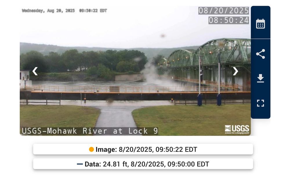
Following the import, OSM mappers immediately started improving the gages' locations, which could be off by as much as few hundreds yards. In effect, OpenStreetMap now has more accurate geometry for USGS monitoring stations than does USGS :)


August 20, 2025 at 7:41 PM
Following the import, OSM mappers immediately started improving the gages' locations, which could be off by as much as few hundreds yards. In effect, OpenStreetMap now has more accurate geometry for USGS monitoring stations than does USGS :)
To complete the import, I wrote a series of open source scripts to fetch and conflate USGS data into OSM. These can be re-run at any time to keep the data in sync without overwriting hand-mapped data


August 20, 2025 at 7:41 PM
To complete the import, I wrote a series of open source scripts to fetch and conflate USGS data into OSM. These can be re-run at any time to keep the data in sync without overwriting hand-mapped data
USGS's streamgages provide critical public data about the state of our lakes and rivers. They're also used by paddlers to plan safe, enjoyable trips. Mapping them accurately in OpenStreetMap allows any app using OSM to easily incorporate gage information


August 20, 2025 at 7:41 PM
USGS's streamgages provide critical public data about the state of our lakes and rivers. They're also used by paddlers to plan safe, enjoyable trips. Mapping them accurately in OpenStreetMap allows any app using OSM to easily incorporate gage information
Last summer I imported 16,000+ USGS gaging stations into OpenStreetMap. Not content with a one-time import, I built a tool to keep the data up-to-date going forward.
I've published a writeup of the project over on my portfolio: waysidemapping.org/projects/usg...
I've published a writeup of the project over on my portfolio: waysidemapping.org/projects/usg...


August 20, 2025 at 7:41 PM
Last summer I imported 16,000+ USGS gaging stations into OpenStreetMap. Not content with a one-time import, I built a tool to keep the data up-to-date going forward.
I've published a writeup of the project over on my portfolio: waysidemapping.org/projects/usg...
I've published a writeup of the project over on my portfolio: waysidemapping.org/projects/usg...
I've mapped dozens of canoe trails in OSM and even helped develop the data schema. Feel free to reach out if you need help getting your trail on the map!

August 18, 2025 at 5:49 PM
I've mapped dozens of canoe trails in OSM and even helped develop the data schema. Feel free to reach out if you need help getting your trail on the map!
However, the Jordan River suffers from severe water diversions that lower the river level at the expense of ecology and float-ability. Parts of the river can rarely be paddled. Hopefully the water trail will increase awareness of water issues in the Salt Lake Valley.


August 18, 2025 at 5:49 PM
However, the Jordan River suffers from severe water diversions that lower the river level at the expense of ecology and float-ability. Parts of the river can rarely be paddled. Hopefully the water trail will increase awareness of water issues in the Salt Lake Valley.
Kudos to the Jordan River Commission for spearheading development of this water trail in the last few years. Good access points and clear portages around barriers invite even the most novice paddlers to experience the water. The river is rare in that most of it can even be paddled upstream.


August 18, 2025 at 5:49 PM
Kudos to the Jordan River Commission for spearheading development of this water trail in the last few years. Good access points and clear portages around barriers invite even the most novice paddlers to experience the water. The river is rare in that most of it can even be paddled upstream.
I've finished mapping Utah's Jordan River Water Trail in OpenStreetMap. Paddlers can follows this well-developed, 51-mile paddle route through the Wasatch Front from Utah Lake to the edge of the Great Salt Lake.
Browse the data in OpenTrailMap:
opentrailmap.us#map=8.79/40....
Browse the data in OpenTrailMap:
opentrailmap.us#map=8.79/40....


August 18, 2025 at 5:49 PM
I've finished mapping Utah's Jordan River Water Trail in OpenStreetMap. Paddlers can follows this well-developed, 51-mile paddle route through the Wasatch Front from Utah Lake to the edge of the Great Salt Lake.
Browse the data in OpenTrailMap:
opentrailmap.us#map=8.79/40....
Browse the data in OpenTrailMap:
opentrailmap.us#map=8.79/40....
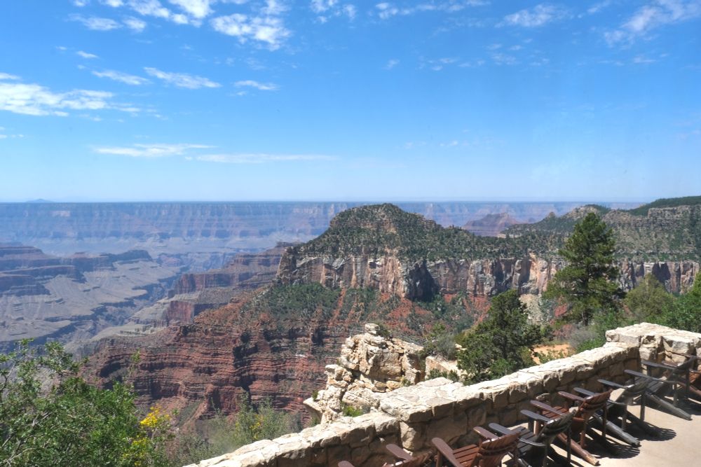
Saddened to hear about the destruction of the Grand Canyon Lodge on the North Rim last month. I was lucky to visit in July 2021, four years and five days before it burned down. I happened to snap a few offhand shots of the structure, now available in the public domain over on Wikimedia Commons.


August 11, 2025 at 8:35 PM
Saddened to hear about the destruction of the Grand Canyon Lodge on the North Rim last month. I was lucky to visit in July 2021, four years and five days before it burned down. I happened to snap a few offhand shots of the structure, now available in the public domain over on Wikimedia Commons.