


Wang Yu
@wangyu-1979.bsky.social
Earthquake Geologist. Associate Professor NTU-TW.
For the Philippines, the latter half of 2025 has not been very peaceful in terms of earthquakes. A Mw 7.4 earthquake occured along the Philippine Trench this morning. Background Image source: Earth Observatory of Singapore.

October 10, 2025 at 3:08 AM
For the Philippines, the latter half of 2025 has not been very peaceful in terms of earthquakes. A Mw 7.4 earthquake occured along the Philippine Trench this morning. Background Image source: Earth Observatory of Singapore.
Open faculty position!
The Department of Geosciences at the National Taiwan University (NTU-TW) invites applications for a tenure-track faculty position.
Details here: web.gl.ntu.edu.tw/index.php/re...
The Department of Geosciences at the National Taiwan University (NTU-TW) invites applications for a tenure-track faculty position.
Details here: web.gl.ntu.edu.tw/index.php/re...

October 7, 2025 at 4:55 AM
Open faculty position!
The Department of Geosciences at the National Taiwan University (NTU-TW) invites applications for a tenure-track faculty position.
Details here: web.gl.ntu.edu.tw/index.php/re...
The Department of Geosciences at the National Taiwan University (NTU-TW) invites applications for a tenure-track faculty position.
Details here: web.gl.ntu.edu.tw/index.php/re...
A LLOF (Landslide Lake Outburst Flood) event happened in eastern Taiwan on Sept 23, causing severe flooding in the downstream area. Despite warnings issued in advance, it killed 17+ people, mostly elders living in 1F. The image taken by Planet Lab today shows the affected area of this LLOF event.

September 25, 2025 at 8:09 AM
A LLOF (Landslide Lake Outburst Flood) event happened in eastern Taiwan on Sept 23, causing severe flooding in the downstream area. Despite warnings issued in advance, it killed 17+ people, mostly elders living in 1F. The image taken by Planet Lab today shows the affected area of this LLOF event.
If you are working on earthquake related research in the Pacific region, it's not too late to consider coming to the ACES workshop in Taipei, Taiwan this November.

July 29, 2025 at 2:16 AM
If you are working on earthquake related research in the Pacific region, it's not too late to consider coming to the ACES workshop in Taipei, Taiwan this November.
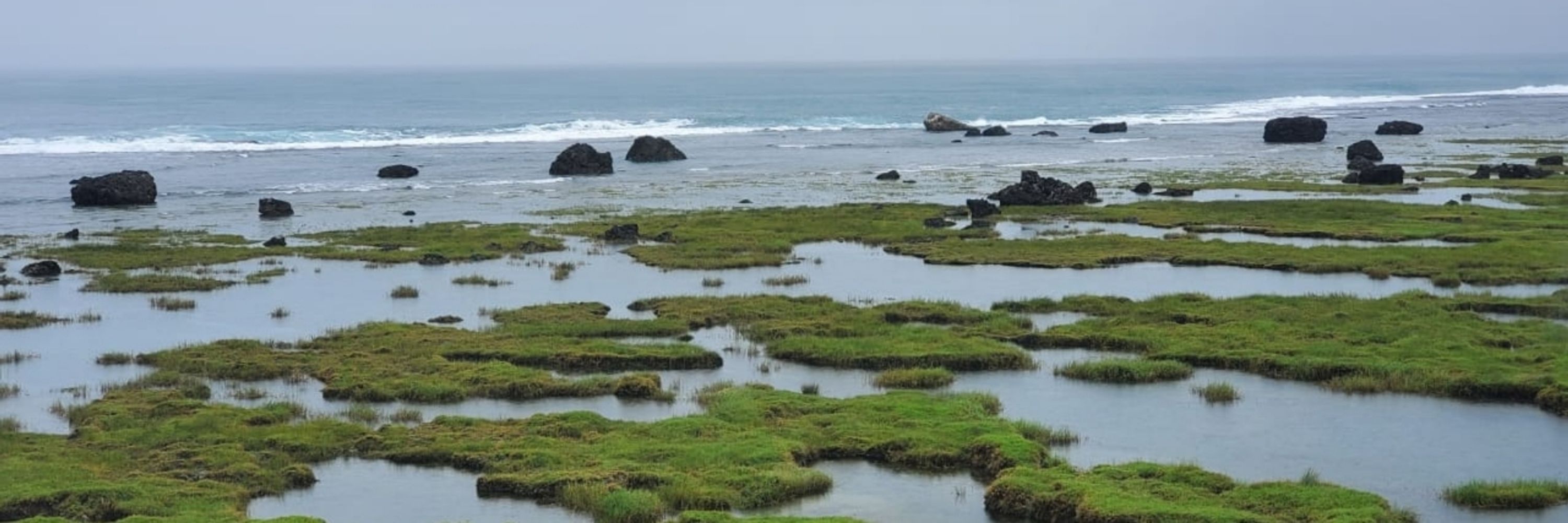
Uplifted reels platform associated with the 2013 Bohol earthquake

July 10, 2025 at 1:13 PM
Uplifted reels platform associated with the 2013 Bohol earthquake
The cave swimming pool in Bohol island, Philippines. People find many different usages to these limestone caves around the world

July 10, 2025 at 1:11 PM
The cave swimming pool in Bohol island, Philippines. People find many different usages to these limestone caves around the world
The change of earthquake swarm near Japan's Tokara islands, from JMA's website. Two clusters developed since the beginning of this episode of activity.
July 3, 2025 at 2:29 PM
The change of earthquake swarm near Japan's Tokara islands, from JMA's website. Two clusters developed since the beginning of this episode of activity.
One year after the 2024 Hualien earthquake, the Taruko gauge is gradually coming back.

May 5, 2025 at 9:55 AM
One year after the 2024 Hualien earthquake, the Taruko gauge is gradually coming back.
Uplifted oyster layer in the Hualien Harbor associated with the Mw 7.4 earthquake last year, eastern Taiwan

March 14, 2025 at 8:17 AM
Uplifted oyster layer in the Hualien Harbor associated with the Mw 7.4 earthquake last year, eastern Taiwan
New observation deck in the Chelongpu fault trench muesum.

March 10, 2025 at 12:04 PM
New observation deck in the Chelongpu fault trench muesum.


We are going to have a special issue in TAO journal addressing the recent M6.4 earthquake in SW Taiwan. Check out more: link.springer.com/collections/...

February 1, 2025 at 10:33 AM
We are going to have a special issue in TAO journal addressing the recent M6.4 earthquake in SW Taiwan. Check out more: link.springer.com/collections/...
Fluvial terraces aling the Dahan River, northern Taiwan. Several other levels of terraces have been inundated by the reservoir in this photo.

January 25, 2025 at 12:55 AM
Fluvial terraces aling the Dahan River, northern Taiwan. Several other levels of terraces have been inundated by the reservoir in this photo.
#Hokudan2025 is starting today online. Unfortunately we can't attend in person this time...

January 23, 2025 at 1:34 AM
#Hokudan2025 is starting today online. Unfortunately we can't attend in person this time...
Today is the 30 yrs anniversary of the 1995 Kobe earthquake, the earthquake that advances our understanding of active faults and seismic hazard analysis around the world.

January 16, 2025 at 11:39 PM
Today is the 30 yrs anniversary of the 1995 Kobe earthquake, the earthquake that advances our understanding of active faults and seismic hazard analysis around the world.
Let the old and unhappy things go away, and let's wish a very new year of 2025

January 1, 2025 at 4:41 AM
Let the old and unhappy things go away, and let's wish a very new year of 2025

Our department is running a student field trip for non-geology major students twice per year for almost 30 years in Taiwan. This is one of the iconic courses in our university. Lots of logistics, paperwork, and headache need to be taken care of by TAs and instructors, but the result is positive.


November 25, 2024 at 11:20 AM
Our department is running a student field trip for non-geology major students twice per year for almost 30 years in Taiwan. This is one of the iconic courses in our university. Lots of logistics, paperwork, and headache need to be taken care of by TAs and instructors, but the result is positive.
The aftermath of Mw 7.2 Hualien earthquake in April this year. #Landslides and #debris flows are now the constant in eastern #Taiwan when heavy rain visits the strong shaked area.


November 18, 2024 at 3:18 PM
The aftermath of Mw 7.2 Hualien earthquake in April this year. #Landslides and #debris flows are now the constant in eastern #Taiwan when heavy rain visits the strong shaked area.
This location used to be the datum #benchmark of #Taiwan. Because of that, the Taiwan datum used to be called "Hu Tze Shan" coordinate system. The monument has now been turned into a continuous GNSS station, and is one of the primary CORS ground control point of the island.

November 18, 2024 at 1:20 PM
This location used to be the datum #benchmark of #Taiwan. Because of that, the Taiwan datum used to be called "Hu Tze Shan" coordinate system. The monument has now been turned into a continuous GNSS station, and is one of the primary CORS ground control point of the island.
Abandoned mechanical house for the ski lift in the Mt. #Hehuan area, #Taiwan. Back to 70s and early 80s, there was an attempt to develop a ski resort in the Central Range of Taiwan. However, the plan fail because of the short winter season and the lack of frequent heavy snow.

November 17, 2024 at 9:33 AM
A very nice-looking open fold in the slate belt at central #Taiwan. You can see vertical cleavages developed within this sandstone-shale formation

November 16, 2024 at 9:15 AM
A very nice-looking open fold in the slate belt at central #Taiwan. You can see vertical cleavages developed within this sandstone-shale formation
The real and the animated scene at #Daiba in the animation of "Tokyo Magnitude 8.0" . This animation describes the damage and human response AFTER an Mw 8.0 earthquake struck Tokyo. This is one of my favorite "Nat Hazards" stories on the screen.


November 12, 2024 at 1:48 PM
The real and the animated scene at #Daiba in the animation of "Tokyo Magnitude 8.0" . This animation describes the damage and human response AFTER an Mw 8.0 earthquake struck Tokyo. This is one of my favorite "Nat Hazards" stories on the screen.
Uplifted #coral #microatolls along the northern #Luzon island. These coral microatolls mark the paleo #sea-level before the subduction zone, or the upper plate earthquakes.

November 11, 2024 at 11:37 PM
Uplifted #coral #microatolls along the northern #Luzon island. These coral microatolls mark the paleo #sea-level before the subduction zone, or the upper plate earthquakes.
More than 4 meters of coseismic coastal uplift close to the northwest corner of the Noto Peninsula. The uplifted oyster line was once close to the MSL...
#能登半島
#能登半島

November 11, 2024 at 2:32 PM
More than 4 meters of coseismic coastal uplift close to the northwest corner of the Noto Peninsula. The uplifted oyster line was once close to the MSL...
#能登半島
#能登半島