


Vivid Weather
@vividweather.bsky.social
Vivid Weather - Weather made simple.
https://discord.gg/fH24ruMbhj We have a community server with up to 600 members, all of which have an avid interest in tracking! Come join us!
https://discord.gg/fH24ruMbhj We have a community server with up to 600 members, all of which have an avid interest in tracking! Come join us!
Pinned

Join the Vivid Weather Discord Server!
Check out the Vivid Weather community on Discord – hang out with 644 other members and enjoy free voice and text chat.
discord.gg
discord.gg/fH24ruMbhj We have a community server with up to 600 members, all of which have an avid interest in tracking! Come join us!
Bahagyang lumakas ang Bagyong Tino (Kalmaegi) bilang isang Severe Tropical Storm habang kumikilos pa-kanluran sa silangan ng Kabisayaan. Inaasahang lalakas pa ito bilang isang Typhoon bukas ng umaga o hapon.

November 2, 2025 at 10:17 AM
Bahagyang lumakas ang Bagyong Tino (Kalmaegi) bilang isang Severe Tropical Storm habang kumikilos pa-kanluran sa silangan ng Kabisayaan. Inaasahang lalakas pa ito bilang isang Typhoon bukas ng umaga o hapon.
Severe Tropical Storm #Kalmaegi (#TinoPH) continues to move West-northwestward and is expected to become a Typhoon by 2pm UTC+08:00 on the 3rd of November as it nears Southeastern Visayas.

November 2, 2025 at 10:09 AM
Severe Tropical Storm #Kalmaegi (#TinoPH) continues to move West-northwestward and is expected to become a Typhoon by 2pm UTC+08:00 on the 3rd of November as it nears Southeastern Visayas.
#23W (#MirasolPH) has made landfall earlier at 3:20AM at the Municipality of Casiguran, Aurora in the Philippines as a low-end official Tropical Storm by the JTWC. Meanwhile, another Tropical Depression recently designated by JMA aiming to be another potential threat in Northern Luzon and Taiwan.

September 17, 2025 at 2:05 AM
#23W (#MirasolPH) has made landfall earlier at 3:20AM at the Municipality of Casiguran, Aurora in the Philippines as a low-end official Tropical Storm by the JTWC. Meanwhile, another Tropical Depression recently designated by JMA aiming to be another potential threat in Northern Luzon and Taiwan.
The Storm Prediction Center has issued a slight risk for severe weather for parts of the northern and central Plains. A 5% chance for tornadoes has been issued for parts of North Dakota and South Dakota. Also, there's a 15% chance for large hail and damaging winds. #severewx

September 14, 2025 at 5:06 PM
The Storm Prediction Center has issued a slight risk for severe weather for parts of the northern and central Plains. A 5% chance for tornadoes has been issued for parts of North Dakota and South Dakota. Also, there's a 15% chance for large hail and damaging winds. #severewx
#22W is set to intensify into a #Typhoon per the #JTWC and #HKO. It is also likely to undergo rapid intensification in the next few hours. It is unofficially a Tropical Storm, and could become a Category 1 by tomorrow evening. Possible landfall on Guangdong on Monday morning.

September 6, 2025 at 8:48 AM
#Hurricane #Kiko is currently intensifying in the open Eastern Pacific. The current BT intensity is set at 90 kt and Kiko is expected to peak as a Category 3 in the coming days. Hawaii may want to watch out for downstream impacts in the coming week or two.


September 3, 2025 at 1:53 AM
#Hurricane #Kiko is currently intensifying in the open Eastern Pacific. The current BT intensity is set at 90 kt and Kiko is expected to peak as a Category 3 in the coming days. Hawaii may want to watch out for downstream impacts in the coming week or two.
Tropical Storm #Kiko has formed in the Eastern Pacific. As it moves west, it has potential to become a strong #hurricane. #NHC currently forecasts an 85 kt storm but some models have it achieve a stronger intensity. Hawaii should watch out for potential impacts down the line.


August 31, 2025 at 5:41 PM
Tropical Storm #Kiko has formed in the Eastern Pacific. As it moves west, it has potential to become a strong #hurricane. #NHC currently forecasts an 85 kt storm but some models have it achieve a stronger intensity. Hawaii should watch out for potential impacts down the line.
The North Atlantic is unusually quiet heading into early September. We currently only have one AOI that has a low chance to form in the next 7 days from the #NHC. Activity should pick up by mid month and we expect mid September through the early part of October to be fairly busy.


August 30, 2025 at 9:18 PM
The North Atlantic is unusually quiet heading into early September. We currently only have one AOI that has a low chance to form in the next 7 days from the #NHC. Activity should pick up by mid month and we expect mid September through the early part of October to be fairly busy.
#Fernand is on a downward trend now. Northernly shear is taking a toll on the system leaving the LLC exposed with convection displaced to the south. Conditions are not expected to improve for Fernand. The cyclone should become non-tropical in around 36 hours.
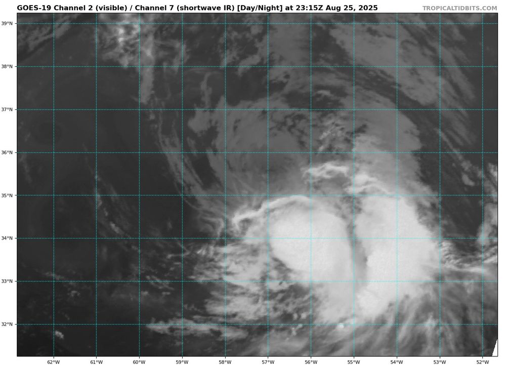

August 25, 2025 at 11:32 PM
#Fernand is on a downward trend now. Northernly shear is taking a toll on the system leaving the LLC exposed with convection displaced to the south. Conditions are not expected to improve for Fernand. The cyclone should become non-tropical in around 36 hours.
UPDATE: Based on recon findings, 90L will be upgraded to Tropical Storm Fernand at 5 pm EST based on ATCF!

August 23, 2025 at 7:55 PM
UPDATE: Based on recon findings, 90L will be upgraded to Tropical Storm Fernand at 5 pm EST based on ATCF!


#99L is likely close to a tropical cyclone right now. A recent ASCAT pass showed 40 kt winds but we cannot tell if 99L is closed based on the pass because of some contamination issues. That being said, MW imagery suggests the low is closed. I would expect a tropical storm soon.


August 22, 2025 at 2:16 AM
#99L is likely close to a tropical cyclone right now. A recent ASCAT pass showed 40 kt winds but we cannot tell if 99L is closed based on the pass because of some contamination issues. That being said, MW imagery suggests the low is closed. I would expect a tropical storm soon.
Large #Hurricane #Erin is currently beginning to weaken as moves to the NE. Erin still remains a large and powerful Category 2 with gales extending almost 500 miles in diameter per the #NHC. Erin should transition into an extratropical cyclone within 2 days.


August 21, 2025 at 8:43 PM
Large #Hurricane #Erin is currently beginning to weaken as moves to the NE. Erin still remains a large and powerful Category 2 with gales extending almost 500 miles in diameter per the #NHC. Erin should transition into an extratropical cyclone within 2 days.
Shear has lowered over #Erin which has allowed for some restrengthening. Erin is now officially from the #NHC a 95 kt Category 2 #hurricane and is expected to regain Category 3 status soon. The pressure has also dropped to 941 mb.


August 20, 2025 at 3:33 PM
Shear has lowered over #Erin which has allowed for some restrengthening. Erin is now officially from the #NHC a 95 kt Category 2 #hurricane and is expected to regain Category 3 status soon. The pressure has also dropped to 941 mb.
Wind shear has taken a toll on #Erin. The LLC is partially exposed with convection being sheared away. #NHC still has the intensity at 90 kt which keeps Erin a Category 2 #hurricane. Shear should relax soon which should allow for Erin to have a short period of restrengthening.


August 19, 2025 at 3:23 PM
Wind shear has taken a toll on #Erin. The LLC is partially exposed with convection being sheared away. #NHC still has the intensity at 90 kt which keeps Erin a Category 2 #hurricane. Shear should relax soon which should allow for Erin to have a short period of restrengthening.
#Erin has took a turn today with a visible struggle to rotate VHTs upshear in the face of strong NWerly shear with a notable vector flip contrasting the upper levels and lower to mid levels.


August 18, 2025 at 6:39 PM
#Erin has took a turn today with a visible struggle to rotate VHTs upshear in the face of strong NWerly shear with a notable vector flip contrasting the upper levels and lower to mid levels.
#Erin is recovering nice post EWRC and is likely intensifying again. The new, larger eye is attempting to clear with VHTs circling the eye. Recon should enter the #hurricane soon to investigate. #NHC still has Erin at 110 kt.

August 18, 2025 at 2:25 AM
#Erin is recovering nice post EWRC and is likely intensifying again. The new, larger eye is attempting to clear with VHTs circling the eye. Recon should enter the #hurricane soon to investigate. #NHC still has Erin at 110 kt.
#Erin is on the verge of completing an EWRC. #Hurricane hunters have reported two eyewalls with the outer eyewall being stronger then the inner eyewall now. In addition, pressure in Erin has dropped during the most recent pass. Erin should begin restrengthening very soon.


August 17, 2025 at 4:53 PM
#Erin is on the verge of completing an EWRC. #Hurricane hunters have reported two eyewalls with the outer eyewall being stronger then the inner eyewall now. In addition, pressure in Erin has dropped during the most recent pass. Erin should begin restrengthening very soon.
#Erin has weakened to a Category 4 #hurricane with winds of 125 kt. We are a bit unsure now of what is causing this weakening but it may be due to shear and a potential EWRC. Some restrengthening is likely in the coming days were Erin will likely reach a secondary peak.


August 17, 2025 at 2:03 AM
#Erin has weakened to a Category 4 #hurricane with winds of 125 kt. We are a bit unsure now of what is causing this weakening but it may be due to shear and a potential EWRC. Some restrengthening is likely in the coming days were Erin will likely reach a secondary peak.
#Erin is now officially a Category 5 hurricane per the @NHC_Atlantic and @53rdWRS, boasting winds of 160 mph and a minimum pressure of 917 mb.

August 16, 2025 at 3:25 PM
#Erin is now officially a Category 5 hurricane per the @NHC_Atlantic and @53rdWRS, boasting winds of 160 mph and a minimum pressure of 917 mb.


A dropsonde within the center of #Erin has found a minimum pressure of 925 mb. This would mean it's pressure is dropping 6.13mb/hr since the first pass at 9:30z, when it was 951 mb. Incredible.

August 16, 2025 at 1:38 PM
A dropsonde within the center of #Erin has found a minimum pressure of 925 mb. This would mean it's pressure is dropping 6.13mb/hr since the first pass at 9:30z, when it was 951 mb. Incredible.
#Hurricane #Erin has continued rapidly intensifying, now reaching an intensity of 145 mph/935 mb. The #NHC expects a peak intensity of 150 mph within the next few hours, however the possibility of a Category 5 is not ruled out. Those in the Caribbean still should watch closely.


August 16, 2025 at 12:00 PM
#Hurricane #Erin has continued rapidly intensifying, now reaching an intensity of 145 mph/935 mb. The #NHC expects a peak intensity of 150 mph within the next few hours, however the possibility of a Category 5 is not ruled out. Those in the Caribbean still should watch closely.
#Erin has explosively intensified into a #Category4 #Hurricane, boasting an intensity of 130 mph/948 mbar. #hurricanehunters are inside the storm as we speak, and #Erin is expected to continue intensifying fast. Those living in the Lesser Antilles should watch carefully.


August 16, 2025 at 10:27 AM
#Erin has explosively intensified into a #Category4 #Hurricane, boasting an intensity of 130 mph/948 mbar. #hurricanehunters are inside the storm as we speak, and #Erin is expected to continue intensifying fast. Those living in the Lesser Antilles should watch carefully.
#Erin is currently a rapidly intensifying #hurricane. VHTs have been rotating around the eyewall over the last few hours. Recon has found that Erin is now a Category 2 with peak winds of 85 kt. The #NHC has Erin peaking as a 125 kt Category 4 in around 36 hours.


August 16, 2025 at 3:02 AM
#Erin is currently a rapidly intensifying #hurricane. VHTs have been rotating around the eyewall over the last few hours. Recon has found that Erin is now a Category 2 with peak winds of 85 kt. The #NHC has Erin peaking as a 125 kt Category 4 in around 36 hours.