


Matt
@ultraplinian.bsky.social
Applications engineer. Enthusiast of geosciences and weather, especially tropical cyclones. Love hiking trails and exploring. Into music and video games.
The depth of the 26°C isotherm in that region of the Caribbean is over 100 meters deep. Melissa, being a slow-mover prior to Jamaica, did cool the shallow surface layer and force upwelling. But that cool surface wake would mix out pretty fast and warm when the water underneath remains warm at depth.
November 4, 2025 at 6:28 PM
The depth of the 26°C isotherm in that region of the Caribbean is over 100 meters deep. Melissa, being a slow-mover prior to Jamaica, did cool the shallow surface layer and force upwelling. But that cool surface wake would mix out pretty fast and warm when the water underneath remains warm at depth.
Thank you for this discussion and the link to that paper. I wish you good luck on your multiple ongoing research projects!
October 30, 2025 at 7:43 AM
Thank you for this discussion and the link to that paper. I wish you good luck on your multiple ongoing research projects!
I wonder if there is enough research needed to warrant a doctorial. Seeing as how the phenomenon suggests a lead into incredibly intense dominant eyewalls. How many sub 900 hPa TCs have actually undergone eyewall mergers instead of replacements prior to peak? Stable eyewalls like Haiyan for example.
October 30, 2025 at 6:58 AM
I wonder if there is enough research needed to warrant a doctorial. Seeing as how the phenomenon suggests a lead into incredibly intense dominant eyewalls. How many sub 900 hPa TCs have actually undergone eyewall mergers instead of replacements prior to peak? Stable eyewalls like Haiyan for example.
Obviously, we have the Lesser Antilles radar that showed Irma's merger. I think Brian may even have that archived.
October 30, 2025 at 5:54 AM
Obviously, we have the Lesser Antilles radar that showed Irma's merger. I think Brian may even have that archived.
This was after the first EWRC when Dorian's eye became very stable. For over 48 hours, the dominant eyewall never succumbed to any concentric outer banding despite MW and satellite data being suggestive of such.
October 30, 2025 at 5:54 AM
This was after the first EWRC when Dorian's eye became very stable. For over 48 hours, the dominant eyewall never succumbed to any concentric outer banding despite MW and satellite data being suggestive of such.
RE: Dorian, there is no report. Only mere speculation and discussion while the TC was tracking towards the Bahamas. We discussed this when all we had at the time was MW imagery, as it was beyond Bahamas long range radar.
October 30, 2025 at 5:54 AM
RE: Dorian, there is no report. Only mere speculation and discussion while the TC was tracking towards the Bahamas. We discussed this when all we had at the time was MW imagery, as it was beyond Bahamas long range radar.
The mergers of each concentric outer eyewall into the inner eyewall instead of a full EWRC are fascinating. I recall Irma and Dorian having mergers prior to their peaks. Though Irma did go through at least one full replacement cycle prior to it experiencing a merger. I don't think Melissa ever did.
October 30, 2025 at 4:55 AM
The mergers of each concentric outer eyewall into the inner eyewall instead of a full EWRC are fascinating. I recall Irma and Dorian having mergers prior to their peaks. Though Irma did go through at least one full replacement cycle prior to it experiencing a merger. I don't think Melissa ever did.
The depressing reality is that this administration does not care. I am surprised he didn't disband the entire research division and fleet. Perhaps only some strong-armed justification by military personnel to convince him otherwise for protecting their infrastructure.
October 30, 2025 at 4:41 AM
The depressing reality is that this administration does not care. I am surprised he didn't disband the entire research division and fleet. Perhaps only some strong-armed justification by military personnel to convince him otherwise for protecting their infrastructure.
Adding a 6th category is trivial and undermines the seriousness of what Category 5 is already supposed to communicate. Whether the TC has 140 kt winds or 180 kt winds, the event is catastrophic. The hazards are extreme for loss of life and destruction to infrastructure.
October 29, 2025 at 1:08 PM
Adding a 6th category is trivial and undermines the seriousness of what Category 5 is already supposed to communicate. Whether the TC has 140 kt winds or 180 kt winds, the event is catastrophic. The hazards are extreme for loss of life and destruction to infrastructure.
We got that with the Ike scale. It is supposed to be used in addition to the Saffir Simpson scale to classify circulation surge threat. Perhaps we're just not effective enough in communicating it. But no, SS Category 5 already meets the requirements for catastrophic destruction.
October 29, 2025 at 1:02 PM
We got that with the Ike scale. It is supposed to be used in addition to the Saffir Simpson scale to classify circulation surge threat. Perhaps we're just not effective enough in communicating it. But no, SS Category 5 already meets the requirements for catastrophic destruction.
Only sensationalism remains to support higher categories. We did need an additional scale to assist the Saffir Simpson to better scale circulation size and surge threat, and we got that with Ike.
October 29, 2025 at 12:53 PM
Only sensationalism remains to support higher categories. We did need an additional scale to assist the Saffir Simpson to better scale circulation size and surge threat, and we got that with Ike.
Sound research driven scientific reasoning is concrete as to why it is pointless to have classifications above tornadic EF-5 scale and tropical cyclone Saffir Simpson Category 5 scale. The atmopsheric criteria required to designate such catastrophic destruction have already been met.
October 29, 2025 at 12:53 PM
Sound research driven scientific reasoning is concrete as to why it is pointless to have classifications above tornadic EF-5 scale and tropical cyclone Saffir Simpson Category 5 scale. The atmopsheric criteria required to designate such catastrophic destruction have already been met.
Difficult times are upon us. I fear you were a part of the first wave of firings? If so, I am very sorry. We are losing immeasurable talent due to ignorance and greed. Ultimately, the nation will suffer. NCEP is critical. These firings are disgusting! Hang in there! It's okay to feel angry and sad.
February 28, 2025 at 11:54 PM
Difficult times are upon us. I fear you were a part of the first wave of firings? If so, I am very sorry. We are losing immeasurable talent due to ignorance and greed. Ultimately, the nation will suffer. NCEP is critical. These firings are disgusting! Hang in there! It's okay to feel angry and sad.
RE: Modeling failures. The TC models did catch up quite swiftly (perhaps next run) after TCG and classification. Perhaps even getting the continued intensification correct into Cuba landfall. A matter of micro vorticity and failure to resolve correctly in the modeling grids for genesis?
October 23, 2024 at 7:02 PM
RE: Modeling failures. The TC models did catch up quite swiftly (perhaps next run) after TCG and classification. Perhaps even getting the continued intensification correct into Cuba landfall. A matter of micro vorticity and failure to resolve correctly in the modeling grids for genesis?
ADT has spiked over the past few hours. Kristy is most likely an upper Category 4 now. Might even reach its MPI of around 135 kts prior to any structural changes or EWRC. Definitely cranking and harmlessly moving away from land as nothing more than eye candy for satellite.
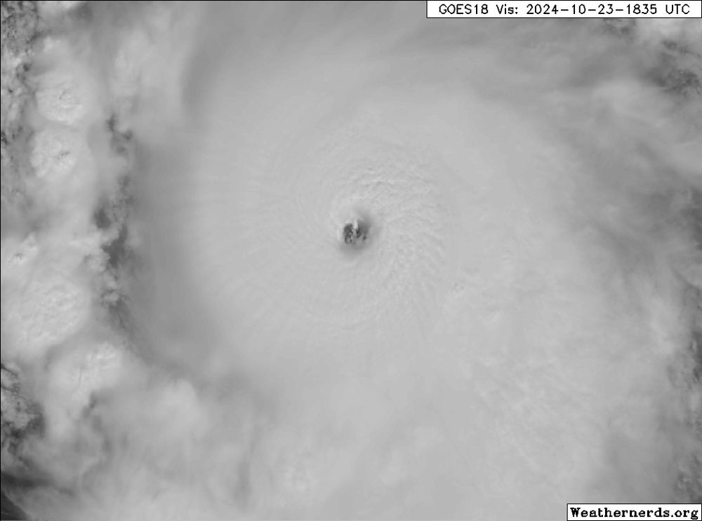
October 23, 2024 at 6:56 PM
ADT has spiked over the past few hours. Kristy is most likely an upper Category 4 now. Might even reach its MPI of around 135 kts prior to any structural changes or EWRC. Definitely cranking and harmlessly moving away from land as nothing more than eye candy for satellite.